Educational hour the most beautiful places. The most beautiful places on earth
We present the most Beautiful places of our country, which should be seen not only by every photographer and traveler, but also by every resident of our vast Russia. Read our material and you will see: we all have something to be proud of!
Natural parks, reserves
Lena Pillars, Yakutia
Lena Pillars is a natural park in Russia, located on the banks of the Lena River in the Khangalassky ulus of Yakutia, 104 km from the city of Pokrovsk. Stretching for many kilometers, the complex of vertically elongated rocks, intricately piled up along the banks of the Lena, cutting through the Prilenskoye Plateau with a deep valley, never ceases to attract photographers and travelers. The pillars reach their greatest density between the villages of Petrovskoye and Tit-Ary.
The height of the rock formations reaches 100 meters. Scientists believe that the formation of rocks began 560–540 million years ago, and the formation of the Lena Pillars as a landform began about 400 thousand years ago.
Natural Park“Lena Pillars” was organized on the basis of the decree of the President of the Republic of Sakha (Yakutia) dated August 16, 1994 No. 837 and the government decree of February 10, 1995 and is subordinate to the regional Ministry of Nature Protection. The area of the park is 485 thousand hectares, the park consists of two branches - “Stolby” and “Sinsky”.
Valley of Geysers, Kamchatka

The Valley of Geysers, one of the largest geyser fields in the world and the only one in Eurasia, is located in Kamchatka in the Kronotsky State biosphere reserve, which is on the UNESCO World Heritage List as part of the natural complex “Volcanoes of Kamchatka”.
The valley is a deep canyon of the Geysernaya River, on the sides of which there is an area of about 6 square meters. km there are numerous outlets of geysers, hot springs, mud pots, thermal areas, waterfalls and lakes. In this area there is an abnormally high biodiversity and high contrast natural conditions and microclimate. The ecosystem of the Valley of Geysers is unique throughout the country. The territory of the valley is protected by a reserve regime.
Since 1992, under an agreement with the reserve, helicopter excursions have been organized here, and there is a strict system of rules for organizing excursions in order to maintain the balance of the ecosystem. In 2008, based on voting results, the Valley of Geysers was included in the list of seven wonders of Russia.
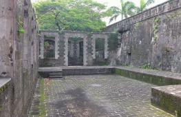
Weathering pillars, Komi Republic

Weathering pillars (Mansi logs) are a geological monument located in the Troitsko-Pechora region of the Komi Republic on the territory of the Pechora-Ilych Nature Reserve on Mount Man-Pupu-ner (“Small Mountain of Idols” translated from the Mansi language), in the interfluve of the Ichotlyaga and Pechora rivers . With this extraordinary place There are many legends associated with it. The pillars are considered one of the seven wonders of Russia.
The weathering pillars are located quite far from inhabited places. Reaching them is in some sense a feat. To do this, by the way, you need to obtain a pass from the administration of the reserve. From the Sverdlovsk region and Perm region there is walking route, from the Komi Republic side - automobile, water and walking routes.
About 200 million years ago, in place of the stone pillars there were high mountains. Rain, snow, wind, frost and heat gradually destroyed the mountains, and especially weak rocks. Hard sericite-quartzite shales were less destroyed and have survived to this day, while soft rocks were destroyed by weathering and carried by water and wind into relief depressions.
One pillar, 34 m high, stands somewhat apart from the others. Six others lined up at the edge of the cliff. The pillars have bizarre outlines and, depending on the place of inspection, resemble either the figure of a huge man, or the head of a horse or ram. It’s true: this place is ideal for a photographer’s imagination! In past times, the Mansi deified grandiose stone sculptures and worshiped them, but climbing Manpupuner was considered the greatest sin.
Curonian Spit, Kaliningrad region

Curonian Spit - a sand spit located on the coast Baltic Sea and the Curonian Lagoon. It is a narrow and long saber-shaped strip of land separating the Curonian Lagoon from the Baltic Sea and stretching from the city of Zelenogradsk in the Kaliningrad region to the city of Klaipeda (Smiltyne) (Lithuania). The name of the spit comes from the name of the ancient Curonian tribes who lived here before the colonization of Prussia by the Germans.
The length is 98 kilometers, the width ranges from 400 meters (in the area of the village of Lesnoy) to 3.8 kilometers (in the area of \u200b\u200bCape Bulviko, just north of Nida).
The Curonian Spit is a unique natural-anthropogenic landscape and a territory of exceptional aesthetic value: the Curonian Spit is the largest sand body, included, along with the Hel and Vistula, in the Baltic complex of sand spits, which has no analogues in the world. The high level of biological diversity due to the combination of different landscapes - from desert (dunes) to tundra (raised bog) - provides insight into important and long-term ecological and biological processes in evolution.
The most significant element of the spit's relief is a continuous strip of white sand dunes 0.3 - 1 km wide, some of them approaching the highest in the world (up to 68 m). Thanks to his geographical location and orientation from northeast to southwest, it serves as a corridor for migratory birds of many species flying from the northwestern regions of Russia, Finland and the Baltic countries to the countries of the Middle and Southern Europe. Every year in spring and autumn, from 10 to 20 million birds fly over the spit, a significant part of which stop here to rest and feed.
Favorable climatic conditions allow you to relax on the Curonian Spit from May to November. In 2000, the Curonian Spit was included in the UNESCO World Heritage List.
Nature reserve "Stolby". Krasnoyarsk region

The reserve is located on the northwestern spurs of the Eastern Sayan Mountains, bordering the Central Siberian Plateau. The natural boundaries of the protected area are the right tributaries of the river. Yenisei: in the northeast - the Bazaikha river, in the south and southwest - the Mana and Bolshaya Slizneva rivers. From the northeast, the territory borders the city of Krasnoyarsk; the border of the reserve can be reached by bus. The reserve was founded in 1925 on the initiative of city residents to preserve natural complexes around the picturesque syenite outcrops - “pillars”. Currently, its area is 47,219 hectares. Submitted to the UNESCO World Heritage List.
Lakes
Lake Baikal, Eastern Siberia

It is unlikely that Baikal needs any descriptions, but still... Baikal is the most deep lake on the planet, the largest natural reservoir fresh water. The lake and coastal areas are distinguished by a unique diversity of flora and fauna. Local residents and many in Russia traditionally call Baikal the sea.
Meaning maximum depth lake - 1642 m - was established in 1983 by L. G. Kolotilo and A. I. Sulimov during hydrographic work. Average depth The lake is also very large - 744.4 m. Besides Baikal, only two lakes on Earth have a depth of more than 1000 meters: Tanganyika (1470 m) and the Caspian Sea (1025 m). One of the visiting cards of Russia, a place that you need to see with your own eyes at least once in your life!
Lake Seliger, Tver and Novgorod regions

Another place that needs no introduction. By the way, Seliger has another name - Ostashkovskoye Lake, after the name of the city of Ostashkov, located on the lake shore. The area of the lake is 260 sq. km, including about 38 sq. km. km there are islands (there are more than 160 of them on Seliger). The largest among them is Khachin Island. The area of the entire pool is 2275 sq. km.
Seliger receives 110 tributaries. The largest are the Krapivenka, Soroga and Seremukha rivers. Only one river, Selizharovka, flows out of it. The lake lies at an altitude of 205 meters above sea level and is of glacial origin. This explains its peculiar shape - it is not a lake in the usual concept, but rather a chain of lakes stretching from north to south for 100 km and connected by short narrow channels. The coastline, more than 500 km long, is rugged - forested headlands, deep picturesque bays jutting into the land, and islands of various shapes.
The water in Seliger is clear, transparency reaches 5 meters. On the shore of the southern part of Lake Seliger are the city of Ostashkov and the New Yeltsy estate.
Lake Kezenoy-am, Chechen Republic

Kezenoy-am - lake on the border of the Vedeno district Chechen Republic and Botlikhsky district of Dagestan. This is the largest and deepest lake in the North Caucasus, located at an altitude of more than 1800 meters above sea level. The surface of the lake is 2.4 sq. km.
The depth of the lake reaches 74 m. The length of the lake from north to south is 2 kilometers, and from west to east - 2.7 kilometers. The maximum width is 735 meters. Length coastline- 10 kilometers.
Lake Baskunchak
Akhtubinsky district, Astrakhan region

Baskunchak is a salt lake with an area of about 115 square meters. km in Akhtubinsky district Astrakhan region, approximately 270 km north of the Caspian Sea, and 53 km east of the Volga. Lake Baskunchak is part of a unique natural complex that includes Mount Big Bogdo. In 1997, the Bogdinsko-Baskunchaksky natural complex was declared a reserve (Bogdinsko-Baskunchaksky Nature Reserve), where a special environmental regime was established on an area of 53.7 thousand hectares.
On the coast of the lake there are deposits of medicinal clays. In June-August, tourists come to the lake to bathe in brine and take mud baths. There is no need to talk about the beauty of these places. There are no fewer photographers here than people who want to improve their health.
Jack London Lake, Magadan Region

Located in the upper reaches of the Kolyma River in the Yagodninsky district of the Magadan region, it lies among the mountains, at an altitude of 803 meters, the length of the lake in the northwest direction is 10 kilometers, depth is 50 meters.
There are many small lakes around Jack London Lake. The most prominent lakes in size are lakes Mechta, Anemone, Gray Chaika, Nevidimka, Neighboring, and Kudinovskie lakes. One of the most beautiful and exotic lakes Far East. Old-timers say that the lake got its name thanks to an unusual find made by the “discoverers”. When the lake was discovered, researchers found Jack London's book "Martin Eden" on the shore.
Lake Elton, Volgograd region

Elton is a salty, endorheic self-sedating lake in the Pallasovsky district Volgograd region, located near the border with Kazakhstan. It is considered the largest mineral lake in Europe and one of the most mineralized in the world. They say that the name of the lake comes from the Mongolian word “Altyn-Nor” - “golden bottom”.
Lake area - 152 sq. km. Until 1882, salt was mined on Elton; in 1910, the Elton medical sanatorium was founded on its shores (moved to a new location in 1945). In 2001, the lake and the adjacent territories of virgin steppes (106 thousand hectares) became part of the State Institution “Eltonsky Natural Park”.
Blue Lakes. Cherek-Balkarian Gorge, Kabardino-Balkaria

A group of five karst lakes in the Cherek region of Kabardino-Balkaria is located at the foot of the rocky ridge from where the Cherek-Balkarian gorge begins. Located at the entrance to the gorge, Blue Lake is a unique natural phenomenon, interesting not only for Kabardino-Balkaria, but also on a national scale. The Lower Blue Lake has several names: Chirik-kel (bulk) - rotten (smelly) lake; Sherej-ana (kab.) - Cherek’s mother; Psykhurey (kab.) - round water (lake), natural artesian well.
The uniqueness of Nizhny blue lake is that with a relatively small surface (only 235×130 m), its depth reaches 258 meters. The surface water temperature in winter and summer is about +9 degrees. Not a single stream or river flows into the lake, but about 70 million liters flow out every day. The lake level remains unchanged, which is explained by powerful underwater sources. The blue color of the water is due to the presence of hydrogen sulfide and the refraction of light rays in the deep pool.
The nature here is quite picturesque: green hills, dense beech forests on steep slopes, and in the distance, in the blue haze, peaks sparkling in the sun. Closer to Babugent the greenery becomes brighter and juicier. Near the village of Babugent there is a fork in the road. At the beginning of the road to the lake in the rock there is a cave in which traces were found ancient site V-X centuries AD. Now many bats live there, and sometimes, in bad weather, shepherds with flocks of sheep take shelter.
Seydozero, Kola Peninsula, Murmansk region

Lake in the Lovozero tundra on the Kola Peninsula. "Seid" translated from the Sami language means "sacred". The lake is located at an altitude of 189 m above sea level. The length of Seydozero is 8 km, width is from 1.5 to 2.5 km.
According to a number of science fiction writers and ufologists, it is one of the supposed places of existence of the Hyperborean civilization. Seekers of the unknown have been exploring these places since 1922.
Lake (reservoir) Zyuratkul. Chelyabinsk region

Zyuratkul is located in the Satka district of the Chelyabinsk region on the territory of the national park of the same name. One of the highest (724 m above sea level) reservoirs in the Southern Urals. The reservoir is surrounded by mountain ranges covered with dark coniferous forests. To the southwest is the Nurgush ridge - the most high ridge Chelyabinsk region. The main river feeding the reservoir is the Bolshoi Kyl. Near the source of the Satka River and the dam there is the small village of Zyuratkul, connected by bus to the city of Satka.
Previously, Zyuratkul was a natural lake. Now it is a reservoir formed by a dam built on Bolshaya Satka. A giant geoglyph was found in the lake area. About forty stone tools made of quartzite were also discovered. The technique of stone chipping makes it possible to date the tools to the Neolithic and Chalcolithic (VI-III millennium BC). Researchers are still inclined to the Copper-Stone Age (IV-III millennium BC). It is noted that at that time Southern Urals there were practically no forests (they appeared only 2,500 years ago), so the figure was easy to construct and then view from the neighboring ridge until it was covered with a layer of soil.
Until the winter of 2012, another popular attraction was located on the shore of Lake Zyuratkul - Whale Pier, which was also called the “Ural Disneyland”. But in the fall of 2012, by court order, it was demolished.
Mountains and volcanoes
Elbrus, Kabardino-Balkaria

Elbrus is a stratovolcano located on the border of the republics of Kabardino-Balkaria and Karachay-Cherkessia. Elbrus is located north of the Greater Caucasus Range and is the highest peak in Russia. Considering that the border between Europe and Asia is ambiguous, Elbrus is often called the highest European mountain peak, thereby including it in the list of “Seven Summits”.
The height of the western peak is 5642 m, the eastern one is 5621 m. The Adylsu, Shkheldy, Adyrsu gorges, the Donguz-Oruna and Ushba massifs are very popular among climbers and mountain tourists. The Elbrus region is the most popular ski resort Russia. The total area of Elbrus glaciers is 134.5 square meters. km. The most famous of them: Big and Small Azau, Terskol.
Altai Mountains

The Altai Mountains represent a complex system of the highest ridges in Siberia, separated by deep river valleys and vast intramountain and intermountain basins. A mountain system at the junction of the borders of Russia, Mongolia, China and Kazakhstan. It is divided into Southern Altai(Southwestern), Southeastern Altai and Eastern Altai, Central Altai, Northern and Northeastern Altai, Northwestern Altai.
The Altai, Katunsky reserves and the Ukok plateau together form the UNESCO World Heritage Site “Altai - Golden Mountains”. Thousands of tourists come to Altai. This favorite place for photo tours and independent trips.
Divnogorye plateau, Liskinsky district, Voronezh region

“Divnogorye” is a hill and museum-reserve in the Liskinsky district of the Voronezh region of Russia. It is located 10 km west of the center of the region on the right bank of the Don River and 80 km south of Voronezh. The museum here was founded in 1988, and in 1991 it received the status of a museum-reserve. Currently, the museum-reserve is one of the most popular and most recognizable attractions in the Voronezh region. Every season, from May to October, it is visited by more than 60 thousand tourists.
The area of the museum-reserve is more than 11 sq. km. Maximum height the plateau above sea level reaches 181 meters, relative - 103 meters (the mouth of the Tikhaya Sosna River at the confluence with the Don, which flows at the foot of the plateau, is located at an altitude of 78 m above sea level).
Dombay-Ulgen, Karachay-Cherkess Republic

Dombay-Ulgen - the top of the western part of the Dividing Range Greater Caucasus(on the border of Abkhazia and the Karachay-Cherkess Republic). Dombay-Ulgen is the highest peak in Abkhazia, located east of the village of Dombay, has three peaks: western (4036 m), main (4046 m) and eastern (3950 m).
From main peak A steep ridge extends to the north, ending in a depression - the “Dombay saddle”. From the Dombay saddle there is a classic route (category 3B), which can be climbed in one day with a descent to the camp.
Putorana Plateau, Krasnoyarsk Territory

The Putorana Plateau is a mountain range located in the north-west of the Central Siberian Plateau. In the north and west, the plateau ends with a steep ledge (800 m or more), while the southern and eastern parts are characterized by gentle slopes. The maximum height of the plateau is 1701 m, among the highest peaks are Mount Kamen (1701 m), Kholokit (1542 m), Kotuyskaya (1510 m). In the north, the Putorana Plateau borders the Taimyr Peninsula. The name Putorana translated from Evenki means “lakes with steep banks.”
The area of the plateau is 250 thousand sq. km, which is comparable to the territory of Great Britain. On the territory of the plateau is the Putorana State nature reserve, recognized by UNESCO as a World Heritage Site.
Marble Canyon Ruskeala, Republic of Karelia, Ruskeala village

Mountain Park "Ruskeala" is a tourist complex located in the Sortavala region of the Republic of Karelia, near the village of Ruskeala. The main object of the complex is a former marble quarry filled with groundwater.
The quarries discovered by Pastor Alopeus began to be developed at the beginning of the reign of Catherine II. The first developments were led by Captain Kozhin, who was advised by Italian specialists. Today, the length of the quarry from north to south is 460 meters, the width is up to 100 meters. The distance from the highest point of the quarry side to its bottom is over 50 meters. Water transparency reaches 15-18 meters.
Ruskeala marble was used in the construction of the most beautiful and significant buildings of St. Petersburg and its palace suburbs. Lined with it Saint Isaac's Cathedral, the floors of the Kazan Cathedral were laid out, the window sills of the Hermitage were made, the windows of the Marble Palace and the facade of the Mikhailovsky Castle were framed, as well as the underground halls of the St. Petersburg metro stations “Primorskaya” and “Ladozhskaya”. In 2010, a significant part of the filming of the film “The Dark World” took place in Ruskeala.
Eastern and Western Sayans. Eastern Siberia

Eastern and Western Sayans - common name for two mountain systems in southern Siberia. There are Western Sayan (length 650 km, height up to 3971 m - Mount Mongun-Taiga, which is the top of the ridge of the same name - highest peak Eastern Siberia, however, more often this ridge is not classified as the Sayan Mountains, but is classified as a separate mountain system- the mountains of Tuva), consisting of leveled and pointed ridges, on which there is no glaciation, separated by intermountain basins, and the Eastern Sayan (length about 1000 km, height up to 3491 m - Mount Munku-Sardyk) with typical mid-mountain ridges bearing glaciers. The rivers belong to the Yenisei basin. The slopes are dominated by mountain taiga, turning into mountain tundra.
The Western Sayan borders Altai in its southwestern part. Main Ridge its - the Watershed Sayan Range with its highest point - Mount Kyzyl-Taiga (3121 m). The Western Sayan ridges are characterized by steep slopes, rugged terrain, and vast areas of stone placers. The height of the ridges in the west does not exceed 2500-3000 m, to the east it decreases to 2000 m.
The Eastern Sayan stretches almost at right angles to the Western Sayan. Its ridges form a system of “Belogory” (Manskoye, Kanskoye) and “belkov”, which got their name because of the snow on the peaks that does not melt all year round. In the central part, in the upper reaches of the Kazyr and Kizir rivers, several ridges form a “knot” with the highest point - the Grandiozny peak (2982 m). In the southeast are the highest and most inaccessible ranges - the Bolshoy Sayan, Tunkinskie Goltsy, Kitoiskie Goltsy, Kropotkin. The highest point of the Eastern Sayan - Munku-Sardyk (3491 m) is located in the ridge of the same name. Between the Sayan ridges there are more than a dozen basins of various sizes and depths, the most famous of which is the Abakan-Minusinsk basin, famous for its archaeological sites. It is worth noting the large number of waterfalls.
Almost everywhere in the Sayan Mountains, dark coniferous taiga spruce-cedar-fir forests predominate, rising in the western and central parts to heights of 1500–1800 m or more; light deciduous cedar forests form the upper border of the forest at altitudes of 2000–2500 m. Animal world as rich as vegetable. The largest city, located in Sayany - Krasnoyarsk.
Shikhany Mountains. Republic of Bashkortostan

Shikhany are isolated hills in the Bashkir Cis-Urals, consisting of four single mountains: Tratau, Shakhtau, Yuraktau and Kushtau, which form a narrow chain stretched along the Belaya River for 20 km. Shihans are located near the cities of Sterlitamak and Ishimbay. They are unique monuments nature - the remains of a barrier reef formed in the warm sea of the early Permian period. The stones from which these shikhans are made contain imprints of ancient plants and animals.
The highest shihan is Tratau (or Toratau). Its height is 402 meters above sea level, and its relative height is 280 meters. At its foot are the ruins of a women's prison - one of the islands of the Gulag archipelago. Shikhan Tratau flaunts on the coat of arms of the city of Ishimbay, is a symbol of the Ishimbay region of Bashkiria. In the past, this mountain was considered sacred.
Volcano Krenitsyn. Sakhalin region, Onekotan island

An active volcano on the Onekotan Island of the Great Kuril Ridge. The largest two-tiered “volcano within a volcano” in the world is located in the southern part of Onekotan Island. The height of the volcano is 1324 m.
The volcanic cone rises in the form of an island inside Lake Koltsevoye, which lies at an altitude of 400 m (diameter about 7 km). The lake is surrounded by a somma - the walls of the more ancient Tao-Rusyr caldera (heights 540–920 m with a base diameter of 16–17 km).
There is only one known historical eruption, which occurred in 1952.
Volcano Tyatya, Kuril Islands

An active volcano on the Kunashir Island of the Great Kuril Ridge, on the territory of the Kuril Nature Reserve. In geographical terms, Tyatya is a stratovolcano of the somma-vesuvius type (“volcano within a volcano”). The height reaches 1819 m (the highest point of Kunashir; in 1977 and subsequent years, the south-eastern part of the edge of the summit crater collapsed and most of the material fell inside the north-eastern crater. As a result of this, the total height of the volcano decreased by about 30-50 meters and is currently probably less than 1800 meters above sea level)..
The height of the somma is 1485 m, it has a regular truncated cone with a diameter of 15–18 km at the base and up to 2.5 km at the annular ridge. The foothills of the volcano are decorated with coniferous-deciduous forests with bamboo and thickets of stone birch and dwarf cedar. In the forests at the foot you can often find a bear. The path to the volcano is difficult, but most tourists get to the volcano from Yuzhno-Kurilsk.
Caves
Orda Cave, Perm region

The Orda Cave is located on the southwestern outskirts of the village of Orda, Perm Territory, on the left bank of the Kungur River. Consists of a “dry” and underwater part. The length of the dry part is 300 meters, the underwater part is 4600 meters. Today, Orda Cave is the longest flooded cave in Russia. In addition, part of the cave is the longest siphon in the CIS - 935 meters.
The cave ranks 21st among the longest gypsum caves in the world. Famous photographer Viktor Lyagushkin dedicated Orda Cave a whole photo project.
Kungur Cave, Perm region

This is one of the most popular attractions in Siberia and the Urals, a natural monument of all-Russian significance. The cave is located in Perm region, on the right bank of the Sylva River on the outskirts of the city of Kungur in the village of Filippovka, 100 km from Perm.
A unique geological monument - one of the largest karst caves in the European part of Russia, the seventh longest gypsum cave in the world. The length of the cave is about 5700 m, of which 1.5 km is equipped for visits by tourists. average temperature air in the center of the cave is +5 °C, relative humidity in the center of the cave is 100%. The Kungur cave contains 58 grottoes, 70 lakes, 146 so-called. “organ pipes” (the highest is in the Ethereal Grotto, 22 m) - high shafts reaching almost to the surface.
Architecture
Nevyansk Leaning Tower. Sverdlovsk region, Nevyansk city

Not everyone knows that in Russia we have our own likeness Leaning Tower of Pisa- an inclined tower in the center of Nevyansk, built in the first half of the 18th century by order of Akinfiy Demidov.
The height of the tower is 57.5 meters, the base is a square with a side of 9.5 m. The deviation of the tower from the vertical is about 1.85 m, with the greatest inclination observed at the lower tier (3 ° 16"). The exact date of construction of the tower is unknown, different sources give dates ranging from 1721 to 1745.
The tower is a massive quadrangle, with 3 octagonal tiers built on top. Inside, the tower is divided into several levels - floors.
The purpose of the first floor is not precisely established. Demidov's office was located on the second floor, and during Soviet times it was a prison. On the third floor there was a laboratory: traces of silver and gold were found in the soot taken from the chimneys of the furnaces. According to one version, Demidov minted counterfeit money here. According to another, here Demidov, secretly from the state treasury, smelted silver and gold, which was mined at his mines in Altai.
Even higher is the so-called “auditory room”. Its peculiarity is that standing in one corner of the room, you can clearly hear what is being said in the opposite corner. The effect observed in the room is associated with the special shape of the ceiling - it is vaulted and at the same time slightly flattened.
On the seventh and eighth floors there are chimes with musical chimes, created by the English watchmaker Richard Phelps in 1730. The tower is completed by a roof and a metal spire with a weather vane mounted on it, made of milled iron, in which the noble coat of arms of the Demidovs is embossed.
There is a legend that the tower tilted because the basements were flooded with all the workers minting counterfeit money. By Resolution of the Council of Ministers of the RSFSR No. 1327 of August 30, 1960, the tower was included in the list historical monuments, subject to protection as monuments of national importance.
Ivolginsky datsan. Republic of Buryatia, village of Verkhnyaya Ivolga

Ivolginsky datsan is a large Buddhist monastery complex, the center of the Buddhist traditional Sangha of Russia, which is the largest Buddhist community in Buryatia. One of the most striking monuments of Russian history and architecture. Located in the village of Verkhnyaya Ivolga, 36 km from the center of Ulan-Ude.
Bird home. Republic of Crimea

Among all the attractions of Crimea, it is not easy to choose just one. But we decided to stop at one of the most inspiring places. Swallow's Nest is an architectural and historical monument located on the steep 40-meter Aurora rock of Cape Ai-Todor in the village of Gaspra (Yalta City Council).
The structure resembles a medieval knight's castle like the Belem Tower or Villa Miramare near Trieste. The first wooden structure on this site was erected for a retired Russian general after the Russian-Turkish War of 1877–1878; it can be seen on the canvases of famous marine painters: I.K. Aivazovsky, L.F. Lagorio, A.P. Bogolyubov, and also in photographs from that time.
The second owner of this amazing dacha was the court physician A.K. Tobin. There is also very little information left about him. After his death, the house was owned for some time by a widow, who sold the plot to the Moscow merchant Rakhmanina. She demolished the old building, and soon a wooden castle appeared, which she called “Swallow’s Nest.”
“Swallow’s Nest” received its current appearance thanks to the oil industrialist Baron Steingel, who loved to vacation in Crimea. Steingel acquired on Aurora Rock country cottage area and decided to build a romantic castle there, which is reminiscent of medieval buildings on the banks of the Rhine. The design of the new house was commissioned from engineer and sculptor Leonid Sherwood, son of architect Vladimir Sherwood, author Historical Museum on Red Square in Moscow.
At the beginning of the First World War, the estate was bought by the Moscow merchant P. Shelaputin, who opened a restaurant in the castle. In the 1930s there was reading room local rest home, but the premises were considered unsafe and closed.
In 1927, Swallow's Nest was damaged during a strong earthquake. Only in 1967–1968 were repairs carried out. In addition to the monolithic slab, the entire structure was surrounded by anti-seismic belts. The tower, increased in height, became more decorative thanks to its four spiers. In 2013, cracks were discovered in the foundation slab, and in the fall the visit was suspended for design work to carry out reconstruction - strengthening the rock.
And 6 more amazing places:
Chara Sands, Trans-Baikal Territory

Chara Sands - tract in Kalarsky district Trans-Baikal Territory, which is a sandy massif measuring approximately 10 km by 5 km. Chara sands are located in the basin of the same name, in the foothills of the Kodar ridge, 9 kilometers from the village of Chara, between the valleys of the Chara, Middle Sakukan and Upper Sakukan rivers. The array is geological monument nature of geomorphological type of federal rank.
BAM station Novaya Chara is 10 kilometers away. The massif stretches from southwest to northeast and covers an area of about 50 sq. km. In no other basin of Transbaikalia are there such large massifs of loose moving sands. Chara sands look like deserts Central Asia. The vegetation is slightly different from the taiga: there are areas with larches, dwarf birches and moisture-loving dwarf cedar. In the northeastern part of the tract there are two small lakes- Alyonushka and Tayozhnoe.
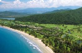
Avachinskaya Bay, Kamchatka Territory

Avacha Bay is a large ice-free bay Pacific Ocean off the south-eastern coast of the Kamchatka Peninsula, it is the main transport “gateway” of the Kamchatka Territory. The main advantage of the bay is that it is one of the largest bays in the world: it can accommodate any ship in the world!
The length of the bay is 24 kilometers, the width at the entrance is 3 kilometers, the total area of the water surface is 215 sq. km. Depth up to 26 meters. The Avacha and Paratunka rivers flow into the bay. The cities of Petropavlovsk-Kamchatsky and Vilyuchinsk are located along the shores of the bay. The bay is the main base of the Russian Pacific Fleet in Kamchatka.
A unique symbol of the bay and its landmark are the Three Brothers rocks, located at the exit to the open Avacha Bay.
Commander Islands. Aleutsky district, Kamchatka region

The Commander Islands are an archipelago of four islands in the southwestern part of the Bering Sea of the Pacific Ocean, administratively part of the Aleutian region of the Kamchatka Territory of Russia. The islands are named after the navigator Commander Vitus Bering who discovered them in 1741. On the largest of them, Bering Island, there is the navigator’s grave. The Commander Islands are a place of mixture of Russian and Aleutian cultures. They have huge potential for the development of northern tourism.
Patomsky crater. Irkutsk region

The Patomsky crater is a cone of crushed limestone blocks on the slope of a mountain in the Patom Highlands in the Irkutsk region. Discovered in 1949 by geologist Vadim Viktorovich Kolpakov. Among the local population it is called the “Nest of the Fire Eagle”, also known as the “Kolpakov Cone”, “Dzhebuldinsky Crater”, “Yavaldinsky Crater”.
This is a unique geological object in its characteristics, which is a ring structure of the central type with a bulk cone composed of limestone and other rocks. The Patomsky crater was formed over a long period of time, about 500 years ago.
The diameter of the crater along the ridge is 76 m. The cone is crowned with a flat top, which is a ring shaft. In the center of the funnel there is a slide up to 12 m high. Overall volume the cone is estimated at 230–250 thousand cubic meters, weight - about a million tons.
Agur waterfalls. Sochi city, Krasnodar region

A cascade of waterfalls located on the Agura River in the Khostinsky district of Sochi. Distance from the Black Sea coast - 4 km. Further up the river - the Middle Falls, then the Upper.
The Lower Agur Waterfall is the first and most interesting of all three large waterfalls on the Agura River. It consists of two cascades: the lower one is 18 m high and the upper one is 12 m high. Below it is a wide and deep pool of blue water. From the Devil's Hole canyon to the Lower Waterfall it is approximately 1.5 km. Behind the first waterfall, a series of stairs and climbs go up, leading through 500 m to the Middle Agur waterfall - 23 meters, and then to the Upper - 21-meter waterfall. Near the Upper Waterfall, to the left of the path, there are rocks called Eagle Rocks.
Vasyugan swamps. Tomsk, Novosibirsk and Omsk regions

Some of the largest swamps in the world are located in Western Siberia, between the Ob and Irtysh rivers, on the territory of the Vasyugan Plain, located for the most part within the Tomsk region, and in small parts - Novosibirsk and Omsk regions and Khanty-Mansi Autonomous Okrug.
The area of the swamps is 53 thousand square meters. km (for comparison: the area of Switzerland is 41 thousand sq. km), the length from west to east is 573 km, from north to south - 320 km.
The Vasyugan swamps arose about 10 thousand years ago and have been constantly increasing since then - 75% of their current area was swamped less than 500 years ago. Swamps are the main source of fresh water in the region (water reserves are 400 cubic km), there are about 800 thousand small lakes, many rivers originate from swamps, in particular: Ava, Bakchar, Bolshoy Yugan, Vasyugan, Demyanka, etc. d.
The Vasyugan swamps are home to numerous local fauna, including rare ones. From rare species animals in swamps live, in particular, reindeer, golden eagle, white-tailed eagle, osprey, gray shrike, peregrine falcon. There are significant quantities of squirrels, moose, sable, wood grouse, partridges, hazel grouse, black grouse, and in smaller quantities mink, otter, and wolverine. Flora also includes rare and endangered plant species and plant communities. Among wild plants, cranberries, blueberries, and cloudberries are widespread.
Now the animal and vegetable world swamps are under threat due to the development of the territory during the exploration and exploitation of oil and gas fields.
Wikipedia materials were used in preparing the article.
Happy travels!

The most beautiful places in the world have always attracted millions of tourists. Whether it's high mountains or endless valleys, huge seas or historical buildings. The sights of planet Earth are an endless and fascinating journey. We have prepared the Top 20 most beautiful places in the world. Watch, discuss and share the post on in social networks with your friends!
20th place - Kungur Ice Cave, Russia
8th place - Faroe islands, Iceland-Norway

Located between Iceland and Norway. More than 50 thousand people live on the archipelago. The total area of the archipelago is 1400 sq. km, and includes 18 small islands, 17 of which have life. Even in the coldest month the temperature does not drop below 0 degrees. All tourists who come to this stunning place are offered: a unique landscape, green meadows, clouds, rocks and, of course, Atlantic Ocean. You will not find such beauties anywhere else!
7th place - Prioksko-Terrasny Nature Reserve, Russia

It is located 12 kilometers from the city of Serpukhov on the left bank of the Oka River. The territory of the Prioksko-Terrasny Reserve, with an area of 4945 hectares, is forested; it is located near the northern border of the mixed forest subzone. Here visitors can see a unique phenomenon - broad-leaved forests meet coniferous forests. Vacationers who come to this place will be able to see more than 960 higher species of plants. Visit the most beautiful places in Russia and this place should certainly be among them.
6th place - Yellowstone Volcano, USA

One of the most popular tourist attractions in the United States of America. Yellowstone National Park is cleverly located in three states at once: Idaho, Wyoming and Montana. The park is famous for its waterfalls, hot springs, rich flora and fauna. This reserve has become an object World Heritage UNESCO back in March 1872. Those who saw the most unusual places on Earth, Yellowstone is always placed in a special category.
5th place - Iguazu Falls, Brazil-Argentina

A real wonder of the world, which is located 20 km from the town of Puerto Iguazu. The legendary national park invites everyone to plunge into amazing world Amazonian forests with incredibly beautiful landscapes. A classic tour of the park is a short walk walk to the waterfalls. A boat ride along a stormy river - and you are already at the foot of the world-famous waterfalls, which you saw from above just half an hour ago.
4th place - National Park Yosemite, USA

The first American nature reserve, which is famous throughout the world for its unique pristine nature. The reserve with the most high waterfall located in the state of California. Most films about Indians were filmed in Yosemite National Park.
3rd place - Neuschwanstein Castle, Germany

This is a majestic structure, which is located near the town of Fussen in Bavaria. Amazing beauty The mysterious castle literally at first sight enchants tourists with its magnetism. The castle was built in 1869 by Ludwig II, who wanted to recreate the era of chivalry. A record amount of money was spent on the construction of this architectural masterpiece - more than 6 million gold marks. After the death of the monarch, the castle was opened to the public, this was done in order to recoup at least part of the Money spent on construction.
2nd place - Niagara Falls, USA-Canada

The most famous waterfall in the USA and Canada. It has become one of the most visited attractions in North America. It got its name from the Indians who lived here, and is translated as “thundering water.” The width of the waterfall is 670 meters, the depth in the middle is about three meters, and the height is 51 meters. Every year 20 million tourists from all over the world come to admire the beauty of the waterfall. For maximum enjoyment of the beauty, tourists are offered observation decks, cable car, galleries and pedestrian paths, and even a tour of hot-air balloon and helicopters.
1st place - Grand Canyon, USA

(Grand Canyon) is among the oldest national parks United States of America. Picturesque corner is one of the most perfect creations of nature on Earth. It is located in the state of Arizona. Until the mid-16th century, the Grand Canyon was inhabited by a tribe of Pueblo Indians who lived in small cave dwellings. The Grand Canyon is a huge tourist complex with numerous parking lots, descents and overnight accommodations. Many people believe that this is the most beautiful place on earth!
Have you read the article about the most beautiful places in the world. Want to visit there? Press Ctrl+D and you will definitely come back here again!
Our world is beautiful and amazing, it is full of mysteries and picturesque places that are worth seeing at least once in your life.
In today’s article we offer a selection of twenty of the most beautiful places on the planet that will not leave anyone indifferent.
Sea of Stars (Maldives)
On the island of Vaathu, after sunset, an amazing sight appears - the surface of the sea turns into hundreds of glowing stars. This effect is called bioluminescence. Energy is released from animal organisms in the form of luminous points.Great Water Hole (Blue Hole) (Belize)
Big blue hole attracts not only tourists and divers from all over the world, but also researchers. It became popular thanks to Jacques-Yves Cousteau. It was created by nature and has the shape of a funnel (305x150 meters).This beautiful and amazing place awaits visitors in Central America in the country of Belize.

Mountain stream cave (Vietnam)
A beautiful cave located in Quang Binh province. Its length is 6 kilometers (the longest in the world). One of its sections reaches a height of 200 meters and a width of 150 meters. Some of its zones are so spacious that a small settlement could easily fit in them.
Colorful rocks of Zhangye Danxia (China)
In the small Chinese province of Gansu there are rocks formed around the Mesozoic era (145 - 66 million years ago). The majestic and picturesque cliffs consist of sedimentary rocks (conglomerates) and red sandstones.Their peculiarity is that they are multi-colored. They combine red, orange, yellow, purple, blue, gray and other colors. From a distance they look like colorful Asian spices. This unique natural creation is included in the World Heritage List.

Hitachi Seaside Park (Japan)
The luxurious park is located in the city of Hitachinaka. It was opened in the early 90s on the site of an inactive American military base. Today the park area is 120 hectares.While in Hitachi you can see the expanses of the Pacific Ocean, but this is not its main highlight. The park is fragrant with daffodils, sakura, tulips, poppies and lilies.

Swing “End of the World” (Ecuador)
The "End of the World" swing is considered one of the most extreme swings in the world. They are located in the mountains in the city of Banos. The extreme thing is that they are located above a considerable abyss at an altitude of 2,660 meters. While riding them, you can admire the majestic and picturesque views of the Andes.
Ice cave under a glacier (USA)
In Alaska, there is an ice cave in a 12 km long glacier. Its peculiarity is that every year it changes its appearance. The ice in the cave is gradually melting, resulting in springs appearing.
Mount Roraima (Guyana, Brazil, Venezuela)
This unique mountain is located in South America at the intersection of three states.The most high point The mountain is located at an altitude of 2,723 meters, and the flat surface of one of the peaks occupies about 34 square kilometers. The local population believes that this sacred place, and the Indians called it “The Navel of the Earth.”

Victoria Falls (Zambia and Zimbabwe)
The uniqueness of the waterfall is not only in its beauty. It is one of the highest and widest waterfalls in the world (height is 1000 meters and width is more than 1 kilometer). Tourists are allowed to walk along its edge.Victoria Falls is one of the main attractions in South Africa.

Fingal's Cave (Scotland)
The clear shape of the cave leads many to believe that it was created by people. But in fact, it was formed by nature during the Paleocene era during lava flows.The surf in a duet with the cave creates musical sounds reminiscent of an organ melody.

Troll Tongue (Norway)
The Troll's tongue refers to a ledge in the Skjeggedal rock. "Language" is located at an altitude of 350 meters above picturesque lake Ringedalsvatn. The ledge is regularly visited by extreme sports enthusiasts and curious tourists. Getting there is not an easy task, as the ascent will take 5 hours.
Cappadocia (Türkiye)
According to scientists, volcanic formations with picturesque canyons, caves and dungeons were formed back in the 5th millennium BC. Cappadocia is considered one of the most famous and popular tourist centers.Hot air balloon rides are very popular in this place. Tourists from all over the world come here to take to the skies at dawn in a hot air balloon and see beautiful landscapes bird's-eye.

Snow-white beaches of the Holy Trinity (Australia)
Are located snow-white beaches in the Holy Trinity Archipelago. Scientists suggest that they were formed over millions of years when sea sand hit the shore.
Grand Canyon (USA)
The canyon is located in the state of Arizona (USA) within the National Park. It is included in the UNESCO list and is considered one of the wonders of nature. Its terracotta hills attract not only tourists, but also world-famous directors for filming films.
Tulip fields (Netherlands)
From the second half of April until May 10, tulip fields are fragrant in the Netherlands. From a bird's eye view, flowers create an incredible kaleidoscope of colors. White, yellow, red, purple and even blue tulips attract tourists from all over the world. The largest fields are located near the coast North Sea and near Amsterdam on the site of a dry lake.
Marble caves (Chile, Argentina)
The marble caves appeared under the influence of natural phenomena and were polished by the waves of the sea. The process of their formation began 6,000 years ago. You can admire this natural beauty at Lake Buenos Aires.
Tunnel of Love (Ukraine)
In the Rivne region in a small locality Klevan is a tunnel of love fragrant with greenery. It was formed as a result of the interweaving of tree branches and bushes in the shape of a tunnel and has become a favorite place for couples and wedding photo shoots.
Enchanted Well (Brazil)
In Bahia (state of Brazil in the northeast) in national park There is a unique well. Its depth is 36 meters and at the same time small stones are visible at its bottom.When the sun begins to shine into the well, it turns a deep blue color. Tourists are advised to watch the spectacle in June and July around noon.

Antelope Canyon (USA)
The canyon is located near the town of Page, Arizona. It became known as Antelope Canyon because its colors resemble the skin of this animal. It was formed over hundreds of years under the influence of wind and water.
Salar de Uyuni (Bolivia)
Uyuni is a dry lake near the desert in Bolivia. It is located at an altitude of 3,650 meters. When it rains, the surface of the salt marsh becomes mirror-like and even allows you to tune satellites.Uyuni has become last refuge for retired steam locomotives that have been resting there for about 60 years.

Beauty is an entirely subjective concept. Looking at the most fascinating places on our planet, a person begins to realize that true beauty is all around him, and it is impossible not to enjoy it. Over endless millions of years, Mother Nature has created so many masterpieces that still not all the most beautiful places on Earth are covered by tourist routes.
Salar de Uyuni (Bolivia)
This is the largest salt lake in the world, and here time seems to slow down. You can even walk on its surface! During the rains, this salt marsh becomes a huge and extraordinary mirror. Here salt is mined, which is exported using antediluvian locomotives, the cemetery of which is located three kilometers from the city of Uyuni. The ideally flat and stable surface of the salt marsh, better than the surface of the ocean, makes it possible to adjust satellite instruments probing our planet. There are islands on the salt lake on which cacti manage to grow - photographs of such vegetation against the backdrop of the sparkling whiteness of the salt marsh are incredibly spectacular.
Different corners of Russia impress with their beauty: from the volcanoes and hills of Kamchatka to the dancing forest Curonian Spit. It is in places like these that the injunctions are placed...
Pamukkale (Türkiye)

In the southwest of Turkey there is a very beautiful geological formation - a rock made of limestone tuff - Pamukkale. Here the river begins, which descends along stone terraces in the form of waterfalls and forms multi-tiered pools. Local residents rather poetically called this place “cotton castle.” Calcium-saturated water provided this unusual landscape with incredible whiteness. To natural terraces and thermal springs Thousands of tourists began to come to the foothills of the mountains every year.
Yunnan Rice Terraces (China)

Rice fields located on mountain terraces Chinese province Yunnan is incredibly picturesque. They stretch for several tens of kilometers, exactly repeating all the curves of the earth's topography. The local ecological system is unique in its formation. In February, rice is planted in the soil, renewed by mountain springs, and the harvest is harvested in early autumn. From late autumn to mid-spring it continues tourist season. Inexperienced travelers are attracted by the mirror surfaces of rice paddies, reflecting the rays of the sun, which, when refracted, provide the entire solar spectrum.
Great Blue Hole (Belize)

Off the coast of Belize in the Caribbean Sea there is a barrier reef, in the center of one of its atolls there is an unusual object - a mysterious, beautiful blue hole, perfectly round and going far into the depths. However, in nature such phenomena occur often; in this case, the size of the hole is striking - the diameter is 300 meters and the depth is 120 meters. Extreme divers love to come here to get new doses of adrenaline. Once upon a time this hole was explored by Jacques Cousteau himself, after him it became famous throughout the world.
Arizona Wave (USA)

Near the border separating the states of Arizona and Utah, on the Colorado Plateau, there is an unusual sandstone formation, which has irregular, intricate shapes with smooth curves and is painted in rich ocher colors, which is given the name “Arizona wave”. All self-respecting professional landscape photographers definitely strive to get here, but to do this they have to overcome many obstacles, because good roads doesn't exist here. The peculiar structure, reminiscent of a frozen stream of caramel, arose as a result of a long process of petrification of sand dunes into solid rock.
Jiuzhaigou National Park (China)

The southeastern Chinese province of Sichuan has many attractions, one of which is the incredibly beautiful Jiuzhaigou National Park. It is located in the north of the province. There are many lakes and waterfalls here, and the special composition of the local water gives them an incredibly beautiful turquoise color. They look especially magnificent in the fall, when their waters reflect the crowns of trees with leaves of all kinds of colors.
Plitvice Lakes (Croatia)

IN Balkan country Croatia also has a mysterious, colorful and incredibly beautiful place - Plitvice Lakes. They are included in the largest national park in Croatia. The landscapes of the park smell of mysticism: it is surrounded by impenetrable dense thickets, which locals call the “devil’s forest.” A chain of lakes is located in one mountain valley; water from each upper lake flows through numerous waterfalls into the lake located below. Since water quickly destroys limestone rock, the waterfalls change every year. In winter, frozen waterfalls are no less spectacular than in summer. All Plitvice lakes are divided into upper and lower.
Valley of the 10 Peaks (Canada)

The nature of Canada is very beautiful, especially its icy beauty. One of the notable natural sites is the Valley of 10 Peaks, which is located at the base of the multi-domed mountain range Vekchemn, which has 10 peaks. Nearby is glacial Moraine Lake, which is a prominent feature of Banff National Park. To better explore the local attractions, there are many trails for tourists. One of the views is called "20 dollars", because a 20 dollar bill was once issued with this landscape.
Mount Roraima (Brazil and Venezuela)

On the border between Brazil and Venezuela there is a very beautiful peak Roraima. In fact, Roraima is the name given to several mountain ranges rising among the Amazon wilds. This place became especially famous after the publication of Arthur Conan Doyle’s most popular novel “ lost World", it was here that he transferred the main events of the novel and populated the local lands, closed from the whole world inaccessible mountains. Indeed, these places can serve as a powerful source of imagination and creative inspiration.
When a tourist is going to travel to any country, it is useful for him to think about his travel plan in advance and choose those attractions...
Monument Valley (USA)

In northeastern Arizona, on the border with Utah, there is the Colorado Plateau, a desert with an unusual and fascinating landscape. It was called Monument Valley because in the middle of the flat desert there are rocks, carved by the wind of unusual shape, scattered, creating alien landscape. Almost all American westerns were filmed here; we have long been accustomed to seeing dashing cowboys on the screen, galloping through the desert against the backdrop of these reddish rocks.
Colored rocks of Zhangye (China)

There are many amazing places in China, for example, the unusually beautiful colorful rocks in Gansu province. They arose during the Cretaceous period. The unusual color scheme is explained by the fact that among other rocks, red sandstone clearly predominates, as well as sedimentary silt rocks that have undergone oxidation after the waters receded from these places. Currently, the Chinese authorities have turned this place into one of the popular tourist routes. Landscape artists adore the local colorful rocks.
Ha Long Bay (Vietnam)

The poetic name Halong translated from Vietnamese means “the bay where dragons find shelter.” Following the bay, the city located on its shores inherited the same name. Perhaps the bay fully lives up to its mystical name, because it contains over 3 thousand small islands, mysterious caves and rocky mountains along the shores. In some caves, penetrating deep into the rocks, attractions are arranged, here exciting adventure routes are prepared for tourists, and multi-colored lighting is provided. Any guest here feels as if he is in the cave of a real dragon.
Iguazu Falls (Brazil and Argentina)

It turns out that even trees can be famous, standing out for their size and unusual shape, age, location, connection with historical...
Iguazu Falls refers to a large complex of 275 waterfalls. They are taller and wider than the famous one Niagara Falls twice. The waterfalls owe their origin to volcanic activity: after the eruption, a huge crack formed in the ground, right under the bed of the Iguazu River, which caused the appearance of a whole cascade of waterfalls. The waterfall looks especially impressive during the rainy season, which occurs in November-March, when the turbulent river brings down 13 thousand cubic meters of water every second.
Crystal River (Columbia)

Although this Colombian river is officially called Caño Cristales, Indian tribes living in the wilds of Central Colombia call it “the escaped from paradise” or “the river of five colors.” There are many natural wonders in the tropics, but this fabulously picturesque multi-colored river is especially original! In different places its bottom is colored pink, red, yellow, green, blue and black. It's all because of the amazing colorful algae that turn the river into a rainbow flowing through the Amazon forests.
Enchanted Well (Brazil)

The magic of this unusual attraction manifests itself every day for only an hour and a half - from 10:30 to noon, when the rays of the sun penetrate into the cave. This well, 37 meters deep, is located at the bottom of even more deep cave(80 m). But the water in it is so clean that at the bottom of the well you can see fragments of trees that fell there in time immemorial. As if by magic, the walls of the cave and the lake at its bottom are suddenly illuminated with a magical blue light. Access to this cave, located in the Chapada Diamantina National Park, is strictly regulated due to the abundance of visitors and the fragility of the local ecosystem.
Geysers are natural fountains formed by water escaping under pressure from underground sources. Most of geysers has volcanic...
Marble Caves (Chile and Argentina)

This place is located on the border between Argentina and Chile and has three names: among the Argentines - Buenos Aires, among the Chileans - General Carrera, and among the local Indian tribes - Chelenko (lake of storms). The mountain climate here is actually very harsh. But there are a lot of fish in the lake, including salmon and trout. On the Chilean side there is the most interesting place - marble caves. There are huge reserves of this valuable stone, in different shades, including even the rarest deep blue. The sunlight entering the cave is refracted in different colors.
Sagano Bamboo Grove (Japan)

In the west of the ancient Japanese capital of Kyoto there is an extraordinary bamboo forest. Thousands of bamboo trunks, like masts, sway gracefully in the wind, while they rub against each other, emitting a subtle ringing sound. Next to the grove stands the ancient Buddhist temple Tenryu-Ji, protected by UNESCO.
Hamilton Basin (USA)

This unusual ecosystem is located near the city of Austin in Texas and is a lake hidden under the dome of a cave. Many thousands of years ago, an underground river flowed in this place through the karst rocks and gradually undermined them until the cave vaults collapsed in the center, revealing the river hidden beneath them to the sun. It turned out to be a very cozy secluded bay with a beach under the canopy. The water in the lake has a rich blue color. Moss and climbing plants hang from the vaults of the grotto in some places, and beautiful limestone stalactites descend in others. Swallows make their nests under the dome, and nearby a waterfall falls from a 15-meter height.
Valley of Flowers (India)

In the western Himalayas, in the upper reaches of the Ganges, there are incredibly beautiful flowering meadows. Almost all plants growing here are endemic. Scientists are closely monitoring the local alpine meadows, which stretch over 88 square meters. km. Magnificent flower meadows are adjacent to mountains, forests and waterfalls.
Among indoor plant lovers, the desire to choose the most beautiful plant for your home most often prevails. Of course, luxurious flowers are very...
Grand Canyon (USA)

The Grand Canyon area is one of the oldest national parks in the United States. This is one of the most large-scale creations of nature that has attracted human attention. The canyon is located in Arizona, and was carved over millions of years by the Colorado River. Until the middle of the 16th century, a tribe of Pueblo Indians lived in the canyon, who settled in small gaps in the walls of the canyon. These are the most beautiful places in the world, so now Grand Canyon has turned into a gigantic tourist complex - there are many slopes, places to stay overnight and parking lots.
Hands to Feet. Subscribe to our channel atThe earth is the most beautiful planet solar system, and maybe the entire Universe. The nature of our planet surprises with its beauty, bright colors, unique views and diverse landscape.
Beautiful caves and golden beaches, beautiful forests and majestic mountains make up the beauty of the Earth. Some of the corners of our planet never leave the pages of fashion guidebooks. But there are places that can rarely be found in such literature.
We open our review with the symbol of the mysterious Myanmar - ancient city Bagan. It is called the city of thousands of pagodas. This place was the capital of the Bagan kingdom. His greatness was so strong that people flocked to Bagan the best minds and masters of antiquity. Thanks to them, they were built Buddhist temples and other beautiful buildings.
 Only a few of them have survived to this day. The most significant structure of these is the Shwezigon Golden Pagoda. It was built in 1057 on the site indicated by a white elephant carrying a bandage, a tooth and a rib of Buddha. These same relics are still kept in the temple.
 Other attractions of Bagan must also be included in the photos of the most beautiful and amazing places in the world: the temples of Ananda, Htilo-Minlo, Shweleikto and the Bu-paya pagoda.
Colored rocks of Zhangye Danxia (China)
 The most Amazing places on the planet can be built by human hands or nature. Colored rocks, which are located in the Chinese province of Gansu, are natural formations of multi-colored sandstones. Recent studies show that more than 100 million years ago there was an ocean here. The silt colored the sandstone and made the rock formations look so original.
 Today, the Danxia mountain peaks near the town of Zhangye are included in the UNESCO World Heritage List. So that tourists can admire the views of these mountains, local residents have built many boardwalks and paths with which you can walk between these amazing mountain peaks.
Yusupov Palace (Russia)
 But, let's return to man-made miracles. In any almanac of the most beautiful places in the world you will find such an architectural monument as the Yusupov Palace. It is located in the very heart of St. Petersburg on the Moika River. Built in the 18th century for the niece of Peter the Great, Princess Praskovye, it only came into the possession of the Yusupovs in 1830. But, since then, he has been associated only with this legendary surname. This palace is the site of the murder of Grigory Rasputin.
Li River (China)
 Another beautiful place in China is the Li River. This is one of the most picturesque water bodies on our planet. Starting as a small stream in the Mao'er Mountains, it runs like a "silk ribbon" through the Guangxi Zhuang Autonomous Region of China. Locals call this river Lijiang. It is recognized as the cleanest river in the Middle Kingdom. Its main attribute is the majestic karst giants. They were formed with the help of water and wind over many centuries. These mountain formations have poetic names and attract tourists from many countries of the world with their beauty.
 You can enjoy the beauty of the Lijiang River by taking a cruise ship or using the service of local gondoliers.
Monastic complex of Meteora (Greece)
 There are many amazing places in our world. If we talk about architectural monuments, then most of them are in Greece. This country, which became the founder of modern Europe, is proud of its legendary “ruins”. But the monasteries of Meteora are no less popular. Their main feature in an amazing arrangement: they are crowning high peaks mountains of Thessaly.
 Christian hermits hid in the mountains from Albanians, Turks and ordinary robbers. Over time, students gathered around them, who built monasteries for themselves and their teachers, amazingly beautiful and reminiscent of the nests of huge birds. The word "Meteora" is translated as "floating in the air."
Volcano Erebus (Antarctica)
 One of the most interesting places in the world is the Erebus volcano. It is famous for the fact that on its territory you can see a lake made of real lava. This natural phenomenon is unique. The volcano was named after the ship of the James Clark Ross expedition, which discovered this natural phenomenon. The glow of this volcano attracts everyone who travels to Ross Lake. It is a kind of calling card of Antarctica.
Rice Terraces (Philippines)
 The list of the most interesting places in the world must be continued with the rice terraces of the Philippines. They are even called the eighth miracle of counting. And this is not surprising. These man-made gardens were built by the ancestors of modern local residents more than 2000 years ago. The plowed, multi-level fields not only fed the Ifuago people, but were also an excellent defensive structure.
Union of Fire and Ice (Kamchatka - Russia)
 When talking about interesting places on Earth, one cannot ignore Kamchatka. On the territory of this peninsula you can find 28 active and 160 extinct volcanoes. If you want to climb fire-breathing mountains, watch salmon spawn and see the largest bears in the world, then be sure to go and temper your spirit with the help of Kamchatka. The amazing nature of this place is conducive to hiking, extreme and sea tourism.
Death Valley (USA)
 One more natural monument is Death Valley. It must be included in all lists of interesting places in the world. Let's not get around this unique place And we. Formed many thousands of years ago at the bottom of the sea, this valley amazes with its natural phenomena. There are literally stones walking here. Leaving bizarre traces on the petrified silt. But, if you decide to come here, then you need to prepare for extreme heat. During the day, the thermometer here rarely drops below 50 degrees.
Guam Gorge (Russia)
 The gorge is located in the upper reaches of the Kurdzhips River in Krasnodar region. The natural beauty of this gorge attracts tourists here all year round. But here you can engage not only in contemplating the magnificent flora and fauna, but also in extreme tourism. Rock climbing is especially well developed in the Gumsky Gorge.
Beach with caves near Algarve (Portugal)
 One of the most amazing places in the world, undoubtedly, are the Portuguese caves, which are located in the very southern province the country of port and the birthplace of Cristiano Ronaldo. The most famous of them is the Algarve de Benagil cave. It is called the most beautiful cave in the world. Wind and sea water– these two creators created a magnificent example of one of best places for traveling the world.
Sagano Bamboo Grove (Japan)
 Many of us associate the beauty of the Land of the Rising Sun with cherry blossoms. In this country they are even creating special tours, with the help of which you can observe the alternate flowering of this plant in all provinces of Japan. But another, no less popular symbol of Japan is the Sagano Bamboo Forest. Looking through photos of the most beautiful and amazing places in the world, you will definitely find several images of a picturesque grove of evergreen bamboos.
 These majestic plants make sounds when the wind blows, reminiscent of the popular wind chimes. This beautiful park was created in the 14th century at the behest of the monk Muso Soseki.
 The nature of Sokotora seems like a setting for science fiction films. Charming vegetation, many examples of which are found only on this island, divine beaches and silence. This is exactly what you need for happiness and a serene paradise holiday.
Lake Baskunchak (Russia)
 He is called the most salt lake in the world. In terms of salinity, Baskunchak exceeds the famous Dead Sea. This reservoir is located in the Akhtubinsky district of the Astrakhan region. Not far from this lake is the Baskunchak Cave. Its one and a half kilometer length attracts speleologists.