For the first time came out for the Ural Range. GUH (Chief Ural Range) - Base "Star"
Good time!
I start a series of posts about the campaign in Ural Mountains 2012.
Start from the end))
Today I will tell in two words about the wonderful place of the recreation center "Star", which is at the foot of the Guha.
From the city of Severouralsk, which is located in the Sverdlovsk region, there is a road through the villages of Bayanovka and Pokrovsk-Uralsky.
This road crosses the Ural Mountains and Taiga and rests on the ridge Quarks.
It is easy to find the base when you are going through this Taiga Graviik, with the right there will be a lapse, on which the Iron Star stands, such a not big greetings from the USSR.
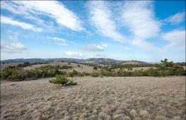
Going around to the database, your gaze appears cozy houses located on a non-big glade, with a stunning view of the main Ural ridge.
1.
It seems that the mountains are small and here not high, but you need to remember that the base itself is located at an altitude of almost 700 meters above sea level.
2.
Prices on the basis are very cheap, day cost 500 rubles per person, which includes living space with bed-place, use of the kitchen,
where there is gas and the Russian oven, the bath, and if you want to shop in the evening, then you will prepare everything for it.
You can play billiards, sit by the fireplace, watch TV with your favorite films.
Here and there are shops and gazebos, mangals, where you can sit romanticly with a friend, chat with friends,
or just silently sit and enjoy the surrounding wildlife.
3.
At the base itself, very kind and friendly guys work. The director is also a very interesting person, a real Russian man, as well as employees of the base (but not today).
The uniqueness of the base is that you can come up with a lot of entertainment ...
Lots of...
i will give a few examples:
You can stupidly come to the database, to sit on its territory to drink Pifko, there is a kebab, go to the bath ...
But it's not about us, and that we are sad there for this and come ...
and what's the point in this, if under the nose the most ancient mountains on the planet, and we went not to sit in place ...
From the base itself, the trail is laid to the very guy, where the place is equipped for fires, gatherings, etc. Literally 15 minutes from the base.
But we are not so lazy and want to go on ...
Employees of the base upside the plateau laid a trail with labels, + tourists Natoptali ...
slowly walking, 30-40 minutes and we are on top, from where the wonderful view of the surrounding mountains opens, and in particular, the Meta stone and its reserve.
You can in advance to buy permission to go to the reserve and make a breakdown before it, passing along the ridge or on him to the north. Excellent route, three days on the base,
then you gather and go to the reserve with Ryukov, then again on the base and rest.
4.
You can not go to such a distance for lazy)).
We go further when we reached the tops to the top, we climb the plateau that transfers us to another planet ...
Here you and the lunar landscapes, and Martian, and what you want ....
5.
The view from the plateau does not describe any words, through each meter you can shoot and shoot ...
We go on the plateau towards the Perm region, the border of our Sverdlovsk region passes clearly in the center of the ridge, on one half of the plateau you are in Sverdlovskaya, on the other half of the Perm ...
moving to Perm ...
6.
Coming to the opposite edge of the plateau, overlooking the valley, and the ridges, mountains, ridges, mountains ... Even begins to spin the head ... from delight and species.
7.
By the way, in the valley, at the same time, a house is worth a house in which tourists, hunters, fishermen stop ...
here you have another route, to live on the basis, then go to the house for a few days, live there, clean life, cook firewood, collect millions of berries and mushrooms,
walking to the surrounding peaks and admire and admire ....
8.
You can also get away from the base to the north on the stream, reach the stream to become the river of sugar and catch the fish there, smoking, the calf is sort too.
but we are on the ridge and admire the species ....
If you go down to the house in the valley, you can see the Huch in all its glory ....
9.
and if you move to the opposite side of Huhu and the plateau from which we went down, you can look at everything at once! There you are also a Kazan stone from which a wonderful look, and you can climb to the "bowl" or go to a height of 1300.
Here is a panorama with "cup"
10.
Also, from the base, you can drive around 25-35km, I don't remember exactly now, and go for a couple of days to the Zhigalansk waterfalls, it is easy to find information about them on the Internet.
Here is such a wonderful base, such a Vedic place, such a northern Ural.
In full report, I will tell you how I got there, as I was talking about what I saw there, well, and naturally a lot of photos and from the ridge and from the surrounding vertices and house))
By the way, there are not one there, but a few, you can live in every day, because everyone is in a different place, with its beauty and romance.
By the way, I almost forgot, here you can ski until June 15.
What successfully made the guys from Tchaikovsky, some kind of ski section.
so there is enough entertainment there, the main fantasy and pretty asses the director of Vasily.
The base lacks a normal site, where all the routes and other advantages will be painted, but I think it's all ahead.
The most important thing is to pon that you need to respect the beauty around us, not to litter and behave adequately like a person!
And finally, I'll show you some more photos from the hike ...
Ural, such a Ural, mysterious as in fairy tales, and pure as a tear of romance :)
11.
12.
13.
14.
All the details in the full report, prepare the material a lot, so that everything is your time.
All good! 
The main Ural ridge - and this is official geographical name mountain Ridgestretching from north to south by 52 kilometers. The main Ural ridge is a peculiar stone belt, the natural border between the Perm and Sverdlovsk region, between Europe and Asia.
Chief Ural Range: Description
The taiga fir-fir and cedar forests reach the back of the ridge to 800-900 meters, then the birch crime and alpine meadows, and the vertices of the ridge are Kurubniki. In the northern part of the ridge, more steep slopes, with a slope of up to 45 degrees. The western slope of the ridge is more flat and even in winter you will not need special equipment. But in the snowy winter snow here is deep.

The foot of the Eastern Slope passes the border Reserve "Tashten stone", one of the few places where the virgin flora and fauna are preserved, which is a generally accepted reference site of North Taiga. Highest point The ridge (1410 meters) is named after the outstanding German natural scientist A. Humboldt, who traveled to Russia and, in particular, studied the Ural district in 1829 at the personal invitation of the Russian emperor. According to the results of the trip, this scientist was written a major work, in which one of the chapters was called the "Ural Mountain System".


If you look at north with verses Humboldt You can see two more tops - mount Pallas., named after another Russian-German natural scientist who visited here in 1770, and mount LephehinaWhich is the name of the academician systematics of wildlife, the first Russian researcher of medicinal plants Ivan Ivanovich Lephehina.
Other significant vertices: Big Khodovskaya Natka (1338.8 m), Socivinsky stone (954 m) and Kazan Stone (1035 m).
Chief Ural Range: GPS Coordinates
- Mount Humboldt - 60 ° 22'21.61 "N 59 ° 11'00.92" E
- Pass Khodovskaya - 60 ° 18'18.46 "N 59 ° 10'30.29" E
- Top athletes skiing - 60 ° 17'12.15 "N 59 ° 09'22.43" E
- Socivinsky stone - 60 ° 07'14.05 "N 59 ° 04'47.73" E
- Kazan Stone - 60 ° 06'32.85 "N 59 ° 03'30.02" E

Chief Ural Range: title history

The entire chain of the Ural Mountains is stretched by continuous hill almost from the Ice Ocean to the most Caspian steppes. But why is this truly a great phenomenon of a lithosphere called so bad? In fact, the rock array is so significant in the height and length, which does not dare to call it except the Ural ridge or just the main one.
In antiquity, these mountains were called. Manci people call him Ner - "Stone", "Stone Wall". He is at all times local residents Natural obstacle to the dominant Western transfer of air flow. These winds carry the bulk of precipitation, significant cloudiness, form the temperature regime. The cold breath of the Arctic also affects. Winter here lasts 5-6 months, snow cover lies an average of 164 days a year.
Chief Ural Ridge It is beautiful all year round, but it is worth considering that in the winter on - from the end of May and October, you can get only on a snowmobile.
Chief Ural Range: How to get?
First you need to get to Severouralsk by car, this is the most convenient option, by bus (buses go from Yekaterinburg to several times a day, cost about 1000 rubles, from Perm direct flight a direct flight once a day, goes in the morning, cost 1300 rubles. ) or by train to Serov or Ivela, the distance from them to Severouralsk 80-90 km. If your car is not increased passability, then the car will have to hire, and in advance.
For autotourists, you can spend at least two days on the route (1 night), but it is in the longest summer daysIn this case, you will have time to see the dawn of the Guha in the southern part and Zhigolaan waterfalls. There will be no time for quarks. Therefore, without taking into account the road, plan two overnight stays.

Can be raised by Northern part Range, but this is still a route for real tourists, because you need to move through the River Vzhod, spending the night in the tent. It is necessary to get along the Crvian road to the Kriv base (60 km, 4 hours) or to the cuttings, and there find the path to the Sosviva River, which is needed to go, and then look for the path through the swamp. Before the foot of the GUHA - approximately 6-7 km. To become for the night, it is better to find the hut on the left bank of the river chassis. And from here you can make radial outputs to the northern or southern part of the ridge. In the summer, the road is very bad. The vertices, convenient to visit from the Base Kriv: Mount Humboldt, Skier Sportsmen, Mount Pallas, Mount Lepöhin.
The main Ural ridge or simply the Gukh - stretched from the south to the north chain of the mountains, dividing the European and Asian part of Eurasia. The length of the ridge exceeds 50 kilometers, it is the largest mountain array In the chain of the Ural Mountains. Includes several large mountains at once, which are of great interest to tourists. Also, the main Ural ridge is the administrative border of the Perm Territory and the Sverdlovsk region. A visit to these picturesque places will open for you the heart of the Ural Mountains.
Mount Humboldt - among the Ural Mountains
SAMI high top In the system of the main Ural Range (GUH) is Mount Humboldt. Its height is 1410 meters. The top of the mountain is located on the territory of the Sverdlovsk region, the foot of the Western part is in the Perm region. Until the XXI century, the mountain was called a lamepa Kymos, by the name of the Lamp River, arising from the foot. Next, Lampa flows into the river Kyutim, part of the Vishera River Pool.
Mount Humboldt is interesting for its harmoniousness. Half of the mountain, 700 meters, occupies a forest, and the second half is rock rocks, isolated from Kurubynik. From the north to the south, the mountain is stretched by 5.5 kilometers, from west - on the east of 4 kilometers. The slopes of the mountain are cool enough, so in the winter time it is possible to gather snow. The most convenient time to visit the mountain is from June to September. Already in the first month of autumn, the first snow and the establishment of snow cover is possible.
The path to Mount Humboldt is organized through the Sverdlovsk region. The cast starts in the city of Severouralsk, from which the main Ural ridge is 40 kilometers. When visiting the mountain, we recommend using the services of the conductor, which knows the area. Despite the fact that the mock climbing does not represent large difficulties, the services of the conductor will help you choose the best route and will not get lost.
GPS Coordinates of Humboldt Mount 60 ° 22'21.63 "N 59 ° 11'00.94" E
Kazan Stone - Gold Memory
Located in the eastern part of the Krasnovishera district of Perm Territory. The southwestern part of the Chief Ural Range chain (Gush). The height of the Kazan stone is 1035 meters above sea level. Despite its relatively small sizes, dominates the terrain. A rock - favorite place Tourists with the initial level of training. It is from him that you can start your acquaintance with the Chief Ural Range.
Kazan Stone is covered with forests about 800 meters. Next, about 200 meters are rock rocks from Kurumnik. Mountain shape is domed, and the top is flat. Kazan Stone is not as cool as the mountain of Humboldt, that is why it is recommended for novice tourists. Snow cover comes off at the end of May. The mountain is open for tourists in both the summer and winter period.
Of great interest is the toponymy of the mountain. Scientists believe that the name of the grief gave an located near the Kazan Gold Minor. The train worked since the beginning of the 20th century, and was closed after the depletion of gold-bearing rocks in the middle of the century. The Surya River, on which gold mined in the past, originates just from Kazan Stone. Also, the river takes his beginning to the Parkovka, whose water rummaged to the ULS River.
Among other peaks of the Chief Ural Range, the Soskiv region can be distinguished. This mountain is located in the southeastern part of the ridge, next to the Kazan Stone. The height of the Soshivinsky stone is 955 meters, so it is somewhat losing to the form of Kazan stone. Climbing the mountain is not of great difficulty, so it is also suitable for novice tourists.
We set off on Socivinsky stone . Socivinsky Stone is a mountain in the Northern Urals (Sverdlovsk Region), adjacent to the Chief Ural Range. It is called the Sosvinsky stone, because it is located near the source of the river big sucker.
So, we went back in the opposite direction, passed by again. After some time, we were opened beautiful.

View from the road to the main Ural ridge.

Pine overlooking the nut.
I must say, we had one of the popular routes of the Northern Urals - "Gigalansk Waterfalls - Socivinsky Stone"
Base "Star" on Sosvinsky Stone.
Finally, they drove up to the overflow, which is located a sign welded from a metal corner in the form of a five-pointed star. It remains very close to tourist base "Star". It works year-round. We arrived there watches at 5-6 pm. The base turned out to be pretty much decent for the Taezhnoy Wildness.
Dining room with attic, on the second floor room for guests with a dozen beds. In the table fireplace, even the TV from the satellite antenna works. Two more houses for tourists; One lacrimal type is about 10 rooms of two and three-beds, another smaller on 4 rooms, it is called a house with a fireplace. At the time when we were there (2007 g), another house was built. Electricity based on the generator, turns on in the evening. Heating furnace-water-water. There is a bath. Toilet on the street. The cost of living 500 rubles / day per person (price of 2012), this includes bed linen, and a bath, and use of the kitchen, bring me with you. There are places for mangals, places for tents, even there is a small wooden springboard for skiers and some kind of football field with a gate.
Between the buildings of the dining room and the bath flows the stream, turning into a large squabble in the river, which merging with a small savum, forms the sugar river.
In general, on the basis of "Star", it is quite good to relax, despite that all this is in close proximity to the guha, because the turbase itself is located at an altitude of almost 700 m.

Dining room turbase "Star" on the background of the mountains.

Off-road technique on the turbase.

The source is a big sugar.
Nature here, not convey words, fascinates. Very beautiful sunsets, the sun, sits just for the mountains.

Sunset over the squirrel stone.
And it was also very interesting to watch the clouds, as they joined the top of the mountains.

Twilight in the mountains.
Put on the squirrel stone.
The next day, the long-awaited rise to the nut. Our conductor was one of the employees of the base. They switched through the stream, and went along the path, not even a path, according to promissory in the forest made by the base employees specifically for tourists. Around old trees covered with moss and lichen, huge fern leaves. Walk, as in a fairy tale in the dense forest. After 15 minutes, the stony slopes of the mountains covered with a parel. Gradually, the rise became cooler, so the nature changed, began to be like a mountain tundra with dwarf trees. Under the feet huge boulders covered with moss.

Mountain tundra. Socivinsky stone.

On one of the glaciers of the Sosvinsky stone.
- "See what it is? From the lower edge of the glacier dripping water, and there is also there, but already a small river flows down the slope, gradually, increasing. Wow, and along the shores of this streaming the grasses of the grass. So he is, what river. "
Before the top left very close. Five minutes and here she is. Oh, what a beauty, everyone already has a spirit captured the picture of the picture. The top of the Sochivinsky stone is a wide plateau, on which closer to the east side, the mountain from the stone boulders of the meter is 3-4 height, and the western part of the plateau is covered with vegetation and there already Perm region. Going to this side of the plateau, overlooking the valley, and the ridges and mountains and again the mountains and ridges. Even the head begins to spin from overwhelming delight. And north and south, too, the ridges of the mountain ranges. This is a whole mountain country and there is no end and edge.

The vertex of the Socivinsky stone.
If you look at the East, from where we came from, the endless taiga with an island of our turbase was spread under their feet.

View from the mountains on the tourist.
Standing there, on top, feel peace and pacification, and limitless happiness.
What other routes can be paved from the "Star" turbase.
Himself, the approach of Sosvivinsky stone took about 40-50 minutes for us - groups of people who do not have experience tourist hikes. Well, if you prepare, have appropriate clothes and shoes, you can go from the squirrel stone further to the west through the valley to the Kazan Stone. And if you go on the ridge to the north, you can walk to the Netscent Stone Reserve. And you can go and along the source and walk to the river a big savage. In general, there would be a fantasy, and the route can be invented.
The best time for tourism in the Northern Urals is July month, since he is the warmest, so to speak the Velvet season In these parts. In July, the snow may still fall, and in August in the mountains it is already cold, upstairs permeating the ice wind. Well, to those who are not afraid of snow, neither rain, at least come here all year round here. Romance. The benefit that the base, as I said, is working year-round. In winter, tourists skiers come here, it is possible to call and sneak snow expanses on this here. By the way on skis here you can ride already up to July. The snow does not melt in the mountains.
Here is wonderful place is on – mountain Socivinsky stone .
In the next article, I will tell you about, do not miss, for this you can subscribe to updates.
Did you like the article? Tell your friends about it !!!
Reprinting materials of the site, including photos, without the permission of the author of the site and without links to articles is prohibited.
Between the Eastern European and West Siberian Plains. Length more than 2000 (with Pai Hoam and Muurgasome - more than 2500) km, width from 40 to 150 km. Many lakes, known Lake Tavatuy (about 50 km north of Yekaterinburg), as well as the so-called Chelyabinsk lakes - several dozen large and small lakes located in the north of Chelyabinsk and part in the south-east of Sverdlovsk regions. Some of them (Uwords, Intash, Welga) have a length of more than 10 km. Chelyabinsk also includes Lakes Turgoyak, Shablich, Big Castles and others.
NameIn the ancient sources, the Urals are partly associated with Riphic and more often with the hyperborean mountains. According to Ptolemy, the Ural Mountains consist of Romanus Mountains (Romaninus - Yaik River or Ufa; Middle Urals), NOSOS, Norossky - Southern Urals, from which the Daix River flow (Urals) and the Northern part - the hyperborean ripese mountains - uniquely watershed between Basins of the Caspian Sea, the Black Sea and Baltic (Sarmatian Ocean) and others. Russian pioneers called him stone, under the name of the Urals, these mountains are first mentioned in Russian sources at the end of the 17th century. The name of the Ural introduced by V. Tatishchev from the Mansiysk "UR" (Mountain). For another version, this is the word of Turkic origin. Geological structureThe Ural Mountains were formed in Late Paleozoa in the era of intensive mountain formation (Hercinsk folding). The formation of the Mountain System of the Urals began in Late Devon (about 350 million years ago) and ended in Triassa (about 200 million years ago). It is an integral part of the Ural-Mongolian folded geosynclinal belt. Within the Urals on the surface, the deformed and often metamorphic rocks of predominantly Paleozoic age are published. The thickness of sedimentary and volcanic rocks is usually strongly broken, broken by breaking, but in general form meridional bands resulting in linearity and zonality of the structures of the Urals. From the West to the East allocated:
At the base of the first three zones according to geophysical data, the ancient, early-membrane, the foundation, complicated mainly by metamorphic and magmatic rocks and formed as a result of several ears of folding, is confidently traced. The most ancient, allegedly Archean, breeds go to the surface in the Tratask ledge on the western slope of the Southern Urals. Moody breeds in the foundation of the Sincline of the Eastern Slope of the Urals are unknown. It is assumed that the foundation of Paleozoic volcanogenic thickness of syncliniodies serve powerful plates of hyperbsitts and gabbroids, places of leaving on the surface in the arrays of the platinum belt and other belts related to it; These plates may be refrigerated by the ancient ocean lodge of the Ural geosynclinal. In the East, in the Ural-Tobolsky anti-clinosition, the yields of the Precambrian rocks are pretty problematic. Paleozoic sediments of the western slope of the Urals are represented by limestone, dolomites, sandstones formed in the conditions of predominantly shallow seas. Eastern intermittent stripes are more deep-water precipitation of the continental slope. Even east, within the eastern slope of the Urals, the incision of Paleozoic (Ordovik, Silur) begins by the changed vulcanite of basalt composition and jaspers, comparable to the breeds of the bottom of the modern oceans. The places above the cut, there are powerful, also changed spilite-sod-liparite strata with deposits of medical-accepted ores. More young sediments of Devon and the Silur partly are presented mainly by Andesito-basalt, Andesito-Dacito volcanites and gravels that meet the development of the eastern slope of the stage of the stage, when the oceanic earth is replaced by the transient bark. Coal deposits (limestone, grain-vaks, acidic and alkaline volcanics) are associated with the latest, continental stage of the development of the eastern slope of the Urals. At the same time, the main mass of Paleozoic, substantially potassium, urals granites, formed pegmatite veins with rare valuable minerals, was introduced. In the Late-Caughty Perm Time, the sedimentation on the eastern slope of the Urals almost ceased and a folded mountain structure was formed here; On the Western slope at this time, the pre-rally regional deflection was formed, filled with a powerful (up to 4-5 km) of the thickness of the wreckage driving from the Urals, Molasses. Triassic sediments have been preserved in a number of pridin-rabbens, the emergence of which in the north and east of the Urals preceded basalt (trapping) magmatism. The younger strata of the Mesozoic and Cenozoic sediments of the hollow platform nature overlap folded structures along the periphery of the Urals. It is assumed that the Paleozoic structure of the Urals laid in the late Cambrian - Ordovic as a result of the splitting of the lateokembrybry continent and the sneakers of its debris, as a result of which the geosynclinal flow was formed with the crust and precipitation of the oceanic type in its inner part. Subsequently, the extension was changed with compression and oceanic wpadin began to gradually close and "overgrow" the newly emerging continental bark; Accordingly, the character of magmatism and sedimentation was changed. The modern structure of the Urals wears traces of the strongest compression, accompanied by a strong transverse reduction of geosyncline depressions and the formation of geagagine scales. MineralsThe Ural is a treasury of a variety of minerals. Of the 55 species of essential minerals that were developed in the USSR, 48 presented in the Urals. For the eastern regions of the Urals, the most characteristic of the Mednocolched Rud (Gajskaya, Sibaye, Degtyar deposits, Kirovgradskaya and Krasnoural group of deposits), Skarno-Magnetite (Goroblandish, High-Ukrainian, Magnitogorskoye Deposit), Titano-Magnetite (Kachkanar, Pervouralskoe), oxidic ore (group of Orsko-Khalilovsky deposits) and chromite ores (deposits of the Campirsky massif), timed mainly to the green-stone belt of the Urals, coal deposits (Chelyabinsk coal pool), placer and indigenous Gold deposits (Kochkar, Berezovskoye) and platinum (ISovskiy). Here are the largest bauxite deposits (North-Ural Banxiton District) and Asbestos (Bazhenovskoye). On the western slope of the Urals and in the Urals, there are coal deposits (Pechora coal pool, Kizelovsky coal pool), oil and gas (Volga-Ural oil and gas region, Orenburg gas and condensate field), potash salts (Verkhnekami pool). Especially the Urals is famous for its "gems" - precious, semi-precious and diverse stones (Emerald, Amethyst, Aquamarin, Yashma, Rodonit, Malachit, etc.). The best jewelry diamonds in the USSR are mined in the Urals. In the depths of the mountains contain more than two hundred different minerals. For example, the reserves of "non-dark ice" - a mountain crystal in the mountain of folk. From the Ural Malachite and Jasper made bowls of the St. Petersburg Hermitage. Geographical aspectsThe conditional border between Europe and Asia passes along the eastern foot of the Ural Mountains. Geographically, the Ural Mountains are divided into five parts:
In the north, the continuation of the Ural ridge can be considered mining system Pai-Hoy, in the south - Muurgujara. VershinsHighest vertices:
NotesLinks
see alsoSources3rd Edition of the Big Soviet Encyclopedia, Article "Ural" Wikimedia Foundation. 2010. Watch what is "Ural Range" in other dictionaries:The constituent conditional border between Europe and Asia begins off the coast Kara Sea In the latitude of 68 ° 30 s. and from here stretches almost without turns almost to the shores Aral SeaIf we assume that Musomrorara Mountains is continued, what is ... ... ... Encyclopedic Dictionary F.A. Brockhaus and I.A. Efron This term has other meanings, see the Kazan Stone. Kazan Stone ... Wikipedia Husband. back, rear surface of a person's body, top in an animal; The longitudinal middle of the back, from the neck to the lower back or the sacrum; | bones, this part forming, vertebral pole; bone ridge, ridge or ridge vertebrae; Their person has 24 ... Explanatory dictionary of Daly - (the ridge is simple.), Range, husband. 1. The same as the spine. || . Back (simple). Hang the bag on the ridge. || . Spin as a symbol of labor, physical energy (collapse). He took everything on his ridge. To be fading to your ridge. 2. Mountain chain, row ... ... Explanatory Dictionary Ushakov ridge - BTA /, m. 1) spine animal, fish. Range Omul. 2) simple. Spine and spin man. Each branch poured us as from the rain pipe, the cold strika climbed under the tie and flowed along the spine (Turgenev). Synonyms: ... ... Popular Dictionary of the Russian Language Ridge, BTA, husband. 1. Spine, and also (simple) back. Bend (breaking) x. (Ind.: It's hard to work; simple). 2. Mountain chain. Comb, slope ridge. Ural x. | arr. Ridge, Aya, OE. Explanatory dictionary of Ozhegov. S.I. Ozhegov, N.Yu. Swedov ... ... ... Explanatory dictionary of Ozhegov |