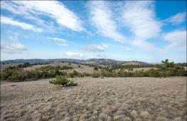
Chui steppe. Mountain Altai: South Chuy Range
The South Chuy Ridge enters mining system Chui proteins in Central Altai. He is located south of the North Chui Range and below it: medium heights - 3000-3500 meters, the maximum - 3967 meters (the peak of the Irbista). At the same time, the area of \u200b\u200bglaciation on the South Chuisk Range more: it includes 243 glaciers, occupying 222.8 square meters. km. But the main foci of glaciation belongs not to the Russian part (on our territory only the northern slopes of glaciers), and to the territory of China and Mongolia.
The mountain region is sharply different from the neighbor in terms of landscapes: even at the lower level there are no extensive coniferous forests, dwarf birch birch predominate, meadows. The reason for this is the local climate (geographical proximity to the Mongolian semi-deserts), characterized by a small amount of precipitation. From the vertices, harsh and exciting views are open at almost 50 km around: the slopes, Chui Steppe and the surrounding ridges are viewed.
The numerous functions of the Jazzor River and the Cold Mountain Rivers (Chagan, Taldura, Tarkhat, Irbist, Taldura, Tarkhat, originated on the ridge.
Sights of the South Chui Range
The main attraction of the district is wildlife: mountain lakes, Cascades of waterfalls, impregnable rocks and picturesque gorges.
- Lake Akkol and Karakul. Akkol is located at an altitude of 2279 m. It pulled out a length of almost 3 kilometers, the width is 400 meters. Water in a lake of a dairy color, for this property it got the name "white". Mute white color is a consequence of glacial and low water circulation in the lake. Karakul is 1.5 km from Akol. The length of the doodle is 2 times less than accoler - 1.2 km, the width of the lake is 300 meters. In the lake, snow is food, so water here is crystal clear. Another interesting fact - Lake lies on absolute height 2300 meters.
- Sofia glacier. This is one of the most massive Altai glaciers. The area of \u200b\u200bthe coating is 17.6 km², and the length is 7.9 km. The top of the glacier is 2620 meters. IN summer time Hiking tours are organized to his foot.
- Taldurin Glacier. Most large glacier At the South Chuisk Range. It covers an area of \u200b\u200b28.2 sq. Km, with a length of 7.5 km. The glacier witnessed the many historical events - during the times of the great resettlement of peoples on it, one of the routes passed, later the caravans from India and China were crossed.
Flora and fauna
The animal world is very diverse, the habitat of animals is clearly divided by high-altitude explanation: snow leopards live on alpine meadows and rocky spurs (they are extremely rare), Yaki and Siberian mountain goats. The marals, wolves and brown bears live below the slopes. In the steppe "housing" steppe eagles, gophers and synts.
The plant world of the South Chui ridge is represented mainly by medicinal herbs: Valerian, mother-in-law, horizon.
Hiking in the South Chui Range
Routes in the South Chui Range are not very diverse. This is due to the fact that most of the pedestrian trails in the Russian mountains laid in Soviet times. And during this period, the territory of the South Chui ridge was a border zone, the tour voices could not attend it.
Most popular tours:
- Horse tours Along the rivers and glaciers of the South Chui ridge with radial exits to the lakes of Karakul and Akkol.
- AUTOTURES With a visit to Taldurin and Sofia glaciers.
- Extreme tours on quad bikes.
Most routes are performed with the combination of transport, in some areas used water transportRadial outputs are carried out on foot.
How to get to the South Chui Range in Altai
The main route from Gorno-Altaisk is held by the R-256 (Chui tract) to the village of Kurai, then you need to move from the federal highway and overcome a few more kilometers along Chui. Further path depends on your route - You can get to Beltir on the primer to the Chui path to Chagan-Uzuna (it is more convenient for visiting the Taldurin Glacier).
On the primer and off-road closer to the spurs of the South Chui ridge, it will be possible to get only on an SUV, but in this case there is almost a day of hike in an active pace (on foot from 10 to 36 km depending on the start place). If your car is not ready for driving on the primer, it is better not to risk - cause emergency service will be problematic. Residents of the surrounding villages willingly offer their transfer services on SUVs. The cost depends on the range of the abandonment and the conditions of patency.
Map schema road route From Gorno-Altaisk to the village of Kurai on Google. Maps.
Public transport to the village does not go. To tourists without a car, we recommend booking tours to the South Chuy Range with departure from Barnaul / Gorno-Altaisk. You can also take advantage of the hitchhiker - in Altai, this is a rather popular way of movement. But, since the road is not close, keep in mind that you have to catch not one car, and the path can stretch more than a day because of the rare travelers in the southern part of Altai.
Video about climbing the South Chuy Range
He is less visiting for tourists, since it is not even visible from the Chui path to the North Chui Range, while the mountains of Yuzhno Chuisi are not even visible from the route. In order for at least to be made to see the magnificent alpine ice shells, you need to get to the village of Ortholy.
The South Chuy Range is truly grandee - with the height of the mountains of 4 kilometers its length from East to West is 70 kilometers. The most popular places here are the accolances and taldura valleys, in which the Sofia and Taldurin Glaciers are located respectively. With no less interest in Travelers of the Valley of Elangash and Karaoyuk. Moreover, if you can travel on an SUV to Elanges, the marsh terrain of the Caraoyuk Valley without any path makes it less affordable.

The road to the accolances and Taldura valleys and their amazing glaciers passes through the village of the ortholist, turn against him towards the village of Beltir. Previously, it was called Kyzyl-Mana, from this distant time and the local roads were preserved, which can be driving except on UAZ and GAZ-66 cars.

If your personal transport is not as passable, then in the village of Beltir you can negotiate with local residents and take advantage of them transport services For racing on the glaciers Taldurin and Sophia. Many people are needed here. 29 kilometers from the Тольтик to the Beltir will overcome without problems any machine - the first five kilometers here lead along asphalt, then "Gravichka" and finishing 12 kilometers are coated with asphalt. I reach the end of the village before the end, you get to the bridge over the Chagan's River - a fork of the opposite shore begins, the left direction leads to the Sofia glacier, and the right to Taldurinsky.

The road from Beltir to the Taldurin Glacier is stretched by 40 km, a couple of kilometers from it ends, and the finishing site tourists are walking on foot. The glacier opens a beautiful view of highest vertex South Chui Range, Mount Iikut.

Before the Sofia Glacier, the path from the village of Beltir is slightly shorter, only 35 kilometers, and this way is much better than in the direction of Taldurinsky. The car will be able to deliver almost to the glacier himself, at the end you will be able to go through the passage of only the last couple of hours.
South Chuy Rangeit extends in the latitudinal director of the West to the east 120 km and is the eastern end of the southern chain of the Central Altai Mountains. The South Chuy Ridge has clearly pronounced boundaries of its territory: from the West he borders with eastern part Katunsky Range, from which R. Argut. The eastern border of the ridge is r. Tarkhata is one of the sources of R. Huya. The northern border of the South Chui Range are Karaga and Jelo River (R. Schagan), which are also the southern border of the North Chui Range. The South Chuushquakes and the North-Chuy are placed on their mountain spurs in the area of \u200b\u200bthe lane. Karagem. This is the so-called Karagam jumper. From the south of the north-chuck is limited to the valley r. Zhasater, who separates it from the mountains of southern Altai.
From the main waterprooper line of the South Chui Harbor, the North will depart eight large spurs serving the watersheds of the right tributaries p. Karagem (r. Ting, r. Kara-Ayry, r. Atbaži, r. Iolado Ayry), left tributary r. Schuy (r. Kara-Oyuk, r. Taldura, r. Chagan) and the origins of p. Sick (r. Elangash, R. Kok-Ozack, r. Tarkhata). The southern spots of the South Chui Range are the watersheds of the right tributaries p. Zhasater, who, in turn, is the right source of R. Argut (r. Bar, r. Tyun, r. Uzurgu, r. TangaT, r. Argen, r. Chikty, r. Akbul, r. Tara, r. Ayut, and others .) And the r. Argut (r. Karasa). The southern sneakers of the South Chuybreak against the northern revisions are shorter and faster losing their height. Specographically only two of them have their names: Taldurin fence and blades.
The Taldurinskaya fence ridge stretched from the main ridge to the north and, as it were, "enters" the Taldurin Glacier for which he received its name. The heights of the ridge are reduced in this direction, the highest point is the top of the key (3733 m).
The ridge of the Belfred also moves to the north of the main ridge and the River Akkol and Kara-Oyuk rivers, and at the same time with them and the glaciers of Sofia and Kara Oyuk.
The ridges are owned by the signs of Tomsk University of V.V. Supozhnikov, who studied this area of \u200b\u200bthe 19th century.
The main weeding is carried by the central part of the ridge from the valley of the river. Kara-Iyra to the valley r. Elangash, with a sharply dissected relief and heights up to 3700 m. On the flanks of the central part of the ridge, the vertices of Iikut (3936 m) and Tim or Irbist (3967 m) are torn. The South Chuy Ridge is the second in Altai after the Katunsky Range on the samples of glaciation. In total, a 243 glacier with a total area of \u200b\u200b222.8 km2, which is located on its northern slopes, has a total of 243 glaciers. The main glaciers - OIST-Ayra, pain. Taldura, Sofia, Yadrintseva. According to the number of the South Chui Range, the carrier glaciers prevail, and in the area - the valley. Click to the eastern part of the ridge, the relief becomes more relaxed, the saddle is more pronounced and smoothed.
For the entire South Chui ridge, the following features are characterized. First, the southern slopes are cooler with the northern slopes and have shorter spurs. Secondly, the olelition of the southern slope is significantly less than Northern. Thirdly, the ridge is very poor woody vegetation, focused only on the valleys of the tribodov r. Zhasater and the tributaries of the Karagema rivers, Taldura and Chagan-Uzun. Fourth, the area climate is significantly land and contrast than in Katun and North-Chui ridges. The snow line rises from west to east from 2900 to 3100 m, on the southern slopes it is 100 - 150 mild.
The most convenient entrance to the beginning of the routes passing through the South Chui ridge, on the vehicle from the north of the Chui tract. The points of the beginning and end of the routes can be the village of Kos-Agach, Mukhor-Tarkhat, Chagan-Uzun, Beltir, as well as the road, connecting the district center of Kos-Agach and Posp. Jasator. Recently, quite complex and long routes have become popular, covering at the same time the North-Chuy and South Chuy Ranges with access to the area. Belukha Katunsky Range.
There is an erroneous opinion that sports category routes passing through the South Chui ridge must be held, in addition, and in the North Chui (most often) or in the South Chui and Katun ridges (less often). Classified Tourist obstacles allow you to plan on the South Chui Range. Inspelling independent tourist routes of almost all categories.
Route map. View from cosmos
The route proposed by me was designed for at least 12 running days, without a stock of bad weather, but now our trip was now organized for a maximum of 10 days, therefore it was decided to decide where we go and on what route depending on where it would throw on the vehicle. Honestly, there was no difference where to go, just to go.
With us in the group there was one young man from the Czech Republic - Valentin. He is Russian, only last 3 years lived in Prague. Therefore, we can say the group was with a foreigner. But as it was brought up by the Russians, he remained. His prague will not redo.
 July 2 went to buy products, and on July 3, after work, a backpack was collected in the evening, because I leave on July 4 in the evening at 20:30, and in the afternoon I still worked.
On July 4, everyone met at the station, and went for landing. Train to Biysk departs at 20:30 local. Tickets at the end of June - price 333 rubles.
In Novosibirsk, in early July, the real summer began. In the evening, the train was +28 +30. The window did not open with us, as it was a spare outlet, and apparently many where they did not open in the car. When it was dark and the people began to fall asleep, then sounds began to be heard from all sides (cracks) resembling a loud reserve the night crickets and grasshoppers, and so all the way to Biysk. Therefore, sleeping well failed. At night, the train was also hot +24.
 The train arrived on July 5 at 6:20 am local to Biysk. There at the station we met a car with which we agreed in advance. On the square before the station there was a huge amount of passenger cars and all taxi drivers. They are delivered at least where.
Surprisingly, there were no gazelles. Strange somehow, last year there were a lot of gazelles. While we were loaded into the car, the attachment area like it quickly became empty, everyone was driving. Loaded into the car as spacious in the sixth machine.
I drove off the station at 6:37. The first kilometer pillar outside the city showed 354 km. And from the 6-8 kilometers station, they drove off, well, it means about 345 km.
7:00 - 373 km of Chui tract. +18 S.
Between 428 and 429 km - the border between Altai Territory and the Republic of Altai.
8:00 - 455 km - Lake Aya. There were many nebulaes on the mountains in the morning.
8:35 - 497 km - Ust-Sema. Those. From Biysk to Ust-semen to go in the morning 2 hours.
9:00 - 527 km.
10:00 - 579 km - the rise in the seminal pass.
 At the seminal pass, he stopped for a few minutes, wanted to sfat Stella in the summer. There, in the morning, the baarmer works early.
11:00 - 632 km. On the road from Onguda, there is a cafe "Farame" - it is for those who suddenly eat there in the area will want. 643 km - to the right, too, have a cafe.
 Stopped on observation site On the pass, Chica-Taman. On the descent of the pass, we saw a freshly broken car, probably turned over. In Kuppeken there is a gas station.
12:00 - 675 km.
Before 684 km on the left there are stones and mounds. By 692 km from B. Jalkan in Katun there is a beach. In front of the frost there is now a new gas station. At 713 km there is a congress to the merger of Chii and Katun.
 Lunch time is already. Stopped in the cafe "Chui-oozia", \u200b\u200bsince something in a white boma no longer wants to eat. There are always a lot of people, they are preparing for a long time and communism there everything smells. And here is not. The people are smaller, everything in the cafe is new and beautiful, the music of Altai players, serve food quickly. After lunch, it went to pofodot petroglyphs, but to my surprise the afternoon they are very clearly visible. When was there in January and then it was better to be visible. But I found one who did not see in the winter. Asked in a cafe, which means Chui-ooza, it turned out to be very simple - the mouth of Chii.
14:00 - 764 km. Stopped for those. inspection of the car. I went to the chuu to puff up. And I discovered the Edelweissions here. I wanted to see them for a long time. But from all the information that this is what they grow somewhere near the white boma on the mountain. And then suddenly near Chii. How lucky.
For some reason stopped in Kura. I do not remember, but the photo speaks about the stop.
15:46 - Chagan-Uzun. Since I didn't really find out where the road to Beltir, and on the map she goes through Chagan-Uzun, they went there to look around the road.
 I figured out: that the road is to the Beltir, but we will not go to the Gazelle there, there you need to move the river. Let's seek UAZ, but the found did not go. We sent us to go to the Beltir through the orthole.
In the orthature immediately near the tract there is a refueling, drove to refuel and the UAZ drove here. In the orthole were approximately 16:30.
 Began to talk with the driver about the slack somewhere behind the Beltir. He agreed to throw us almost to the Taldurinsky glacier. I agreed to drive for 1500 rubles. Filled him 30 liters of gasoline and on the road.
With the driver was small child, Then he fell asleep very quickly. Neither something unusual - the driver must be drunk, otherwise you can not get there. Well at least did not ask for a drink. The eyes were red and in a bunch.
Now, as for sure to get to Beltir: If you drive around the entire orthature on the Chui tract, at the end of the village there will be a pointer to the orthole - to the right, we turn together and go, there will be two bridges through one. The first 5 km of asphalt, then up to 17 km. Riotray gravel, and then to the Beltir himself up to 29 km again asphalt. Erupt any car.
 The road went farther from the tract and gained height. Places were wild and lifeless. Here it is a Chui steppe, like pictures from Mars, only the color is not red, but yellow. Stones, clay, sand and all. And nothing else. No herb. Impressive when you see for the first time. There are no photos as they did not stop. Finally got to Beltir.
The epicenter of the earthquake was here in kilometers 30. The village of the village demolished, everything that was from stone. Wooden houses are probably all restored. There is a floor of the village, and there are no halves. For those who have collapsed at home built a new Beltir, not far from Kosh Agach, and who probably did not want to leave live here. I drove to the ancestors of the driver, he left a baby there and went further.
The driver could not be silent, I tried to talk all the time. Topics were 2: the first one - he tried to hint for us that everything depends on it here, and that if he wants that we can and not go to the glaciers, the second - he tried to prove that we were from travel agency, and that I am here in This group guide, since I sat on the front seat and paid money.
At the end of the Beltir, there will be a school stadium on the left side, after him the road turns to the left, and then immediately right to the bridge across Chagan. moved across the bridge. There is a fork of roads, left to Chagan to Akolla, and we went to the right on Taldura. The road on Taldur only for SUVs, on simple cars there should not go there. Not to drive. The car overheated, especially did not want to touch after the stop. At one of such a stop, while the driver lay wet dirt with grass on the engine, took a photo of the Taldura Valley.
On the way, not far from Beltir on the left Skola was some kind of tent camp of 5-8 tents. We drove a landslide, after the earthquake. This is something incredible. I could not take a picture. On the slope of the mountain, a large portion of the forest, probably meters 150x150 skils along the slope of several tens of meters. Incredible.
The road in some places was completely bad, already questions appear: I will pass further or not. But better UAZ for these places is not. They drove to the Jellow River to 19 o'clock, and our Altaeca said that he would simply be able to drive, there is a bad road, and that he will not even move across the river. I had to be discharged, especially for a long time I wanted to get out of the car and even go on foot. They paid him the remaining 1000 rubles, with 510 poured 30 liters of gasoline in the orthature.
 Before us river. Looking around, they realized that they had nowhere to go on the stones, would have to go. Changed from whom there were shoes, took backpacks and went. The river is completely small, less than knee. After the river transition, the question arose: where to spend the night. Search and found meters at 300 lonely tree, and near him a good green Polyana, but far in a kilometer of the winter.
Let's go to the tree, and began to break the camp in the meadow near him. Hurry only to pull the awning and get the tents, the rider was discovered from the winter of wintering. Arriving, he quickly explained that it was his buds here and so that we left here. To the question where we will go, because of the evening, he explained that somewhere far up Taldura.
They agreed that we would put the tent closer to the river, where less than herbs and more stones, and I will not hit my legs to mise my feet. Having agreed, the Altaeca for another 10-15 minutes followed us that we were doing and, promising to come in the morning to check, retired in the direction of the winter. And we continued to break the camp.
Put the tents, and I was already pulling me somewhere on the slope of the mountain picked up, do not sit here near the tents. The sun was already in the slope, the sky was with small clouds. It was warm in the evening +15 C.
When climbed on the slope, there was a couple of Altai modern graves. They were fenced with a fence (from animals probably). A very little higher was the road to Karagham Pass (N / K) to Karagham Polyana. It went on the road a little up, then went down. The road goes down to the Jellow River and there connects to an expensive along the Taldura River. The road here on the pass is good. Fresh traces are visible. Do not believe those who will say that the Karagham Polyana is not to get there - everywhere fresh traces and several. Near the Jeloy River on a small slope discovered the ancient mounds. Since it was already evening, there was no sun, everything was already gray, I decided to come here in the morning to take a picture of everything.
When the Altais came, I talked a little with him, asked about the translation of words and names. He said that this place is called Kyzyltash. And really here the left slope of the valley was red. Somewhere stones were the reddish themselves, and somewhere on the stones there were a lot of red lichens, as can be seen in the photo. Taldura River Valley is wide and many forest. Here, where we got up anywhere where there are no footprints, we probably have the first here, all the altars triggered probably or usually this place is all passing by day.
In the evening the temperature dropped to +10 s, but still not as in the North Chuy ridge, always in the evening +5 s. All the sky tightened and sometimes scared the rain. I expected that it would be as usual on the rain in the evening and for several hours. But for some reason he was not.
Reserved the GPS height - 2100 m. GPS receiver was an old model, so it measured height by atmospheric pressure. In the evening, I could show one height, and in the morning 100 meters above.
On the Google Earth map, the height is about 2085 m.
Passed the day (evening) - 0.5 km.
In the morning, all the sky was tightened. +6 C. This is quite normal. As I wanted in the evening, I went to take a picture of the gorge of the Jellow and Kurgan River. Gorge of the Jellow River, completely reddish shades.
We were afraid in the morning, fell asleep the stones of the dice, collected things and went at 8:40. Almost immediately began to drip the rain. Wintering past, the Altaca did not seem, probably slept or left for his Altai.
We go on the road. Everywhere fresh traces. From this there were conclusions that we were deceived yesterday, about the fact that he could not drive here.
After wintering, a small take-off on the tilt of meters by 50 is probably. There was a small kurgan of stones and a couple of ribbons on the branch. On the pass, the rain ended, stretched clouds and appeared the blue sky and the sun, it became hot, had to remove the upper clothes.
 After the descent was a wetlastic glade. Perhaps this place may be difficult for the passage of UAZ. If so, then the altar did not lie then. Then there was a small river, which was held on the shedding logs. Travel through her UAZ is also questionable. If this places of UAZ would go, he would have been able to get to the most recent Zimonia. And if you do not go, then it will be possible to drive only on GAZ-66.
Then the road goes to the other coast of Taldura, and therefore the shore was barely determined by the trail. The river valley is wide. As it is unusual, everything is the color of the slopes, there are sands, wetlands, many colors.
 On the other coast, Taldura saw one winter kip. And then a little further another wintering "Teetura." Near wintering no one was visible.
Soon they reached the place where the road passed back to the left bank of Taldura. We walked and thought that there was a ferrode or that. And the bridge over Taldura saw to our surprise.
 Stopped not far from the bridge to rest, not far there was a small hill and climbing him, discovered small waterfall Meters 5 in the gorge and moreover, it was covered with a still not melted ice, as well as next to the river, also lay more ice. Rested and went further. The road in some places go up and loops on the sides to cut off straight straight on the rocks.
 And finally, the long-awaited glacier appeared for the next turn. To a greater extent, I wanted to see the Sophia Glacier, and then Taldurinsky. But let him be Taldurin first.
Going down the road a bit down to the next wintering "Kokyaryk". There was no one too. All on summer pastures. But it can be seen that they live here. Already prepared fuel for the winter.
Next to the winterings everywhere the garbage and empty glass bottles from vodka are lying. Here is the love of Altaians to nature and your home. It's just like in big cities. It does not interfere with your garbage, I took and threw out here. Pa Altai need vodka only in plastic bottles to sell so that they can then be burned.
 Near the wintering rested a little and went further to look for a place for lunch.
We go further, and another winterer seemed to be in the way, which was not on the map, the haze was smoking. There's someone here. For several hundred meters to wintering, in the course of the movement on the right, a small lake was discovered under the rock and trees near and decided to arrange lunch there. At 12:15. Temperature +18 C.
The place is very good. From here even visible the top of the glacier and the top of the mountains. The valley often encounter edelweissions. The vertices of the mountains are closed with clouds.
 They diet, rested and went further. Passing by wintering, no one saw, only the door to the bath got a little and closed. Here also harvested fuel for the winter.
When we moved away from 100 or more from the wintering meters (and I turned around everything and watched the winter) a woman came out of the bath. Probably she was alone here, so I did not go out when we passed by.
 Closer and closer approached the glacier, everything is better and better visible. Taldura began to have very large spills. They walked along the road until she rested into the rock and ended. They realized that the road goes to the other side, as was drawn on the map.
Pereobuli shoes and began to look for a brother. I had to return to meters 100th. Spills are very broad, but not deep.
 It was two for insurance, suddenly a pit or you can slip.
The depth was a bit above the knee. Water is cold, while you go on the water to the fingers quickly freeze, then you're warmed up on the stones, then frozen in the water. The width of the spill is probably more than 100 meters, the main beds 2 or 3.
They went on the grass on the other side, pereobulsya in dry shoes from whom she was. Since we are then going to the Leningrad pass, then in vain, then not to go decided to find a place under the Bivak under the rise in the pass. With the pass, the gorge was descended and the river flowed there.
 In this place and began to look for a place under the tent. Meters 150-200 from Taldura rising a bit up the forest found a place under the tent. There are no fire here. We were here the first. Firewood in the forest. The sun shines. And mosquitoes also come across.
In the evening I went through Taldura in the direction of the glacier, there is nothing to do anyway. On the spills of the river a lot of animal traces: from goats, rams. And also met traces of a big cat. The last wintering was never seen.
Reserved GPS height - 2370 m.
On the Google Earth map, the height is approximately 2335 m.
Passed the day - 18.5 km.
In the morning there was almost clean sky. What I always and expect in the morning. This year, on July 7, I did not let down, as in the past - the whole day was raining (bathed all day, and then I almost did not fully swim in Ore).
Today, radial access to the Taldurinsky glacier. Neither the morning before breakfast escaped to Taldura to make several pictures, and then suddenly the weather would deteriorate, even though these will be.
 They had breakfast, took with them only clothes, iron, food for lunch, gas and dishes. Everything else remained in the camp.
Released from the camp at 8:45. They reached the last wintering kyzyl mana. Here, too, did not see anyone, but the place is hooked, the fuel is harvested. It was probably the biggest winterier in the Taldura Valley. Many herbs. There are no roads here to wintering, it goes on the spill of the river. The traces of this year are visible, probably from GAZ-66. So it is guaranteed to get there to GAZ-66.
They walked along the spills of Taldura, there are many fresh traces from goats, rams and not clear someone. We decided to take a picture of the group on the background of the glacier.
Parking places Along Taldura did not see here. From the rise to the passage of Leningrad to New Moraine reached the hour. There first a small lift to Morane, and then you can say the hollow.
 On the Morane there is a couple of places where you can get up with a camp, one place is very large, tents 10 can be placed. There are bushes, but it is possible to cook here for gas.
It became well now you can see the entire glacier and the language of the glacier. Another hour with a little from the beginning of the Morane reached the release of the glacier. Dressed cats and went to the glacier. Exit to the glacier approximately at an altitude of 2540 m.
 If suddenly someone wants to go to the glacier without cats, then I would not advise it. The bias though not big but good. In the photo it is clear that to the right of ice goes Seal comb. It can be reached above on the glacier and here it is possible when it is possible to go to ice without cats without cats, but it is certainly better not to do.
 Iikut becomes visible all better and better. The top of the mountain turns out to be made of a ridge located in the direction of the valley. It is very interesting that of course.
Raised to the glacier for about an hour. At about 12:15 pm reached the median crest on the glacier, there are big stones on the ice. We approached them and stopped there to have lunch there. Height is approximately 2700 m.
I gave the gas burner at the duty officer, and until they prepared lunch went a little higher and to take a picture of the icefall to the left.
 From there, Olga 3734 m is visible very well. She was probably a blonde, all white.
Above the glacier, closed and open cracks have already begun, since we were without any ropes, then did not go further. Pofotographed, returned to all.
 The weather was great. On the glacier +12 S. Blue sky, some clouds. It is better not to come up with. Simply mountain resort Some.
After lunch, they rested and I suggested to fold on the stone tour. Maybe someone will accidentally see him there.
 Before the departure was photographed in the glacier.
Went back at 14:00. Descent to Moraine, where the cats dressed in the opposite side took 30 minutes. Everything is very melted.
Here on the Taldurin Glacier and in general in the Taldura Valley very interesting stonesAlmost in every stone there are layers of mica, where very small, where more. All this glitters in the sun. And when you go, then all the stones are glittering. In the photo, of course, this is not visible.
 There are stones yellowish as in the photo, but such a bit, and mostly all gray. Therefore, it is possible to perceive it all as gold and silver. Incredible. Before that, I have not seen such in Altai. Places of interesting color was water. Like liquid caramel.
 On the way back we got to us small blue lakes on the Morne. When they went there, they were not seen.
Walking in the Morane and Valley a variety of color pleases - all green, yellow, red and various combination of these colors. This is not what is on the schha. Not so.
Well, already reached the wintering. Although they went without backpacks, but almost no strength.
On the way back in one place, Dean bush of the golden root was caught.
The camp came at 17:30. Completely tired.
The day was very hot, even for the mountains +22 C.
The glacier is about 8.0 km.
At the glacier rose about 1.5-2.0 km.
Passed the day - 20.0 km.
At night there was no rain. Somehow strange all this and not familiar. You expect that it will rain and get ready for him, but it is not. In the morning there was a haze in the sky.
Have breakfast. Of course, this is not the whole breakfast, of course.
Released at 8:40. We went first on the forest up, went to the river. It proceeds into the gorge of the depth of meters 10-20. When you go on Taldura and see this gorge, it seems that it will be incredibly going there. And when you go there, it seems to be nothing.
The slopes here are cool and there is a danger, so that the stone does not arrive at the top. Yes, if a small, good, too, would be little. Casket would not help anyway.
 Raised, we rose, but there is no end. The forest is almost not visible at the bottom. But finally, you can see at the top of pressure. The river disappeared, under the stones goes. It is not even heard.
 It became visible where to go to the passing pass.
Many beautiful stones under the legs.
After the lift, you need to go straight and left, on the pass there. Then they switched the stream.
 And came to a very beautiful blue lake. They went to here from the parking lot 2 hours.
Nobody unexpected him here to see. On the maps it is not. But, now, looking at the Google Earth map, this lake can be guess. The height here is about 2840 m. Those. Already scored 500 meters of height.
 Although in front of the lake just rested, but here they again stopped relaxing, drinking water, to take pictures, enjoy the mountains, flowers and color of water. Some were not to tear off the water.
After the lake, first walked along the stream, it is better to go to his left bank and go through the stone, the right is very wetting. Next begin the moraine. In the course of the movement, if it is necessary to keep the right side, there is a small gorge between the shafts.
Then they came to another small greenish lake. Rested near him. It is very small.
 Soon the language of the glacier appeared and it became clearly visible to the pass itself (at the top of the left).
Under the language of the glacier is a small but very dirty lake. Here we approached 12 o'clock. The height of approximately 2980 m. The temperature of +18 S. The sky was tightened, so it was not hot. It was even good.
 Near this lake on Gaza prepared lunch. They caught, rested a little and at 13 o'clock went on to the pass. In the course of the movement, it is necessary to climb the left to the left. And keep along the glacier. So I approached the transferred takeoff itself. Height of about 3100 m.
The rise in the Leningradsky Pass 3300 m (1B) began. At first there was nothing, then the bias reached 45 degrees. It became hard and difficult.
 The difficulty mostly amounted to the fact that the structure of the stones here is layered, the stones are thin as the plates and a small size, they slide under each other. There is a slip of the legs, and there is a danger to fall.
We climbed to the pass who he wanted and who could or who could seemed easier. As it should be a group well stretched. There is no end to this takeoff. It is not clear when it is over.
Finally go to pressure. Usually after writing a new takeoff appears. But here it was not. After being written immediately, the saddle itself and on it in the middle of the tour.
 Hooray. On the pass. Time was about 15 hours.
GPS height - 3280 m.
Google Earth - 3320 m.
For the designation rounded, and let the Leningradsky passage 3300 m (1B) pass.
From the pass, the entire Tura-Oyuk Valley and Lake Tura-Oyuk were seen. On the pass itself towards the lake there was a little snow. It's great, in case of lack of water there is something to drink.
 Looking aside and looking at the saddle of the pass, you can make some conclusions: the saddle is very smooth, the rammed and round. So here it was not so long ago there was a glacier on the pass, he aligned everything here. Very beautiful sight. And now the glacier is not.
 In the snow found snow a big cat. Probably, this traces of a snow leopard - Irbis. There is even not far from the Mountain Irbist.
Soon the whole group rose to the pass. Everyone is tired. But the forces come quickly. Rested and began to be photographed.
 Sitting on the pass, saw a group, which from the Tura-Oyuk Valley rose to the pass. This is all delighted, and more surprised. In the Taldura Valley, we did not see tourists at all. And here suddenly tourists are already right on the pass.
Started down the downstairs to the left at 15:40. Rested on stones. We decided to wait for the group.
 After the descent of one third of the pass, it became clear. What is better to descend now down straight, and not traverse. Everyone began to descend, and I stayed to wait for the oncoming group. There were 5 people (2 children). From Yaroslavl.
Having become acquainted with them and talking a little, I began to catch up with my own. Caught up with them at the bottom. Near the wrong snowfield, there was water. There and rested.
GPS height - 3000 m.
Google Earth - also 3000 m. Those. Take off from this side Pass 300 m, and from the side of 200 m.
 The map shows another top lake Tura-Oyuk. With the pass, it is not visible, but when you descend it becomes visible. It was beautiful. Dark green and covered was not yet miserable ice. I would like to go there.
Rested and went to the lake. When I looked from the pass down, it seemed that it was not far from the foot of the foot to the lake. The slopes are almost all the crouched grass. The path should be short and easy. But it was mistaken. First, everywhere there were old moraine, and there were not many of them. Walked for a long time.
 Before the lake began to meet the bushes of the golden root.
So approached the lake at about 18:15.
Looking towards the lake, and realizing that there was no forest in general, and with almost no dwarf, they decided to get up immediately at the beginning of the lake. Approximately 100 meters to the lake. Polyana here was without stones and not wetlands.
 Preparing food on gas. Next to the cliffs showed bushes in which some firewood were made. Then we are right on the stones, I found that there are even more firewood on the stones. So in the evening we will cook tea on the bore and sit while drinking tea stuck near him. Than in the evening and engaged.
GPS near the lake - 2746 m.
Google Earth Lake Height - 2720 m.
Temperature Day was +16 +18 C.
From parking to the blue lake before the pass - 2.3 km.
Prior to the language of the glacier approximately - 3.9 km.
Sedlovna Pass Leningradsky - 5.4 km.
And to the lake from the saddle - 3.8 km.
Passed the day - 9.2 km.