The value of the highest absolute heights of the Caucasus. A message about the Caucasus mountains
Geographical position
The Caucasus Mountains, stretching between the Black and Caspian Seas, are the natural border between Asia and Europe. They also separate the Near and Middle East. Due to their vast territory, they can be safely called "the country of ridges and uplands." There are two versions of the origin of the word "Caucasus". According to the first, that was the name of the epic king from the poem "Shahnameh" - Kavi-Kaus. The second hypothesis ascribes a name to the translation: "Supporters of the sky." Geographically, the Caucasus is divided into two mountain systems: Big and Small. In turn, they also have subdivisions into ridges, chains and highlands.
Height of the Caucasus Mountains
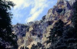
The Caucasus is often included in the list of the "best". For example, the highest permanent village of Ushguli (Georgia) is located here. It lies on the slope of Shkhara (5068 m above sea level) and is included in the UNESCO list. Ushba has acquired a gloomy fame among climbers as the most difficult summit to conquer - "four-thousanders". The mysterious Ararat is surrounded by biblical legends. Is there and alpine lakes- Ritsa, for example. And the Zeigalan waterfall (North Ossetia) is the largest in Russia (600 m). This attracts many climbers, sportsmen and just tourists to the region. The highest snow-capped peaks, glaciers shining in the sun, hard-to-reach passes, narrow gorges, waterfalls and turbulent, bubbling rivers - all these are the Caucasus Mountains. The heights of the highest peaks - Elbrus (5642) and Kazbek (5034) - surpass Mont Blanc (4810), which is considered the culmination point of Western Europe.
Myths and legends

The Caucasus is mentioned in the Bible. In the Book of Genesis, the ark of the righteous Noah stuck to Mount Ararat during the great flood, and from there a dove brought an olive branch. Jason sailed to the land of sorcerers Colchis (the Black Sea coast of the Caucasus) for the golden fleece. Here the eagle of Zeus punished Prometheus for giving people fire. The Caucasus Mountains also have their own regional legends. Every nation living on the slopes of this majestic country of glaciers and snowy peaks - and there are about fifty of them - composes legends and myths about them.
Geology

Caucasus - young mountain system... It was formed relatively recently - about 25 million years ago, in the Tertiary period. Thus, the Caucasus Mountains belong to the Alpine folding, but with insignificant volcanic activity. Eruptions have not been observed for a long time, but earthquakes are frequent. The biggest one last happened in 1988. Then 25 thousand people died in Spitak (Armenia). The main geological wealth of the mountains is oil. The reserves are estimated at 200 billion barrels.
Flora and fauna
The Caucasus Mountains are home to many species of wild animals. The gorges are inhabited by bears, golden eagles, chamois, wild boars, and argali are also found. There are also endemics - species that, except for the Caucasus, cannot be found anywhere else on the planet. These include the local species of the leopard, lynx. Before the beginning of our era, manuscripts mention the presence of Caspian tigers and Asiatic lions. The biological diversity of this region is rapidly declining. The last Caucasian bison died out in 1926, the local subspecies - in 1810. In this region of subtropical forests, alpine meadows and alpine lichens, 6350 plant species were recorded. More than one and a half thousand of them are endemic.
The Caucasus is a mountain system located in Eurasia between the Black and Caspian Seas. The mountain range stretches for 1100 km from the Taman Peninsula and Anapa to Absheron Peninsula near the city of Baku.
This territory is usually divided according to several criteria: into the Greater and Lesser Caucasus, as well as into the Western (from the Black Sea to Elbrus), Central (from Elbrus to Kazbek) and Eastern (from Kazbek to the Caspian Sea). The mountain system reaches its greatest width in the central part (180 km). The mountain peaks of the Central Caucasus are the highest on the Main Caucasian (Dividing) ridge.
The most famous mountain peaks of the Caucasus are Mount Elbrus (5642 m) and Mount Kazbek (5033 m). Both peaks are stratovolcanoes. Moreover, Kazbek is considered to be extinct, which cannot be said about Elbrus. The opinions of experts on this matter differ. The slopes of the two most high mountains The Caucasus Mountains are covered with snow and glaciers. The Central Caucasus accounts for up to 70% of modern glaciation. For more than a century of observation of the Caucasus glaciers, their area has significantly decreased.
To the north, from the foot of the Greater Caucasus, an inclined plain extends, which ends with the Kumo-Manych depression. Its territory is dissected by side ridges and river valleys. The largest rivers in this area can be considered the r. Kuban and Terek. To the south of the Greater Caucasus are the Colchis and Kuro-Araks lowlands.
The Caucasus Mountains can be considered young. They formed during the Alpine folding about 28-23 million years ago. Their formation is due to the movement to the north of the Arabian lithospheric plate to the Eurasian one. The latter, pressed by the African plate, moves several centimeters a year.
Tectonic processes in the depths of the Caucasus continue to this day. Geological structure Elbrus speaks about the great activity of the volcano in the recent past. Several powerful earthquakes occurred in the Caucasus in the 20th century. The most destructive was the earthquake in Armenia in 1988.
Seismic stations operating throughout the Caucasus register several hundred earthquakes every year. Experts say that some parts of the Caucasian ridge “grow” by several centimeters a year.
Caucasus in Europe or Asia?
This issue should be considered more in political and historical aspects. The Caucasus Mountains are located in the center of the Eurasian plate, so the division can only be arbitrary. The border between Europe and Asia was proposed by the Swedish officer and geographer F. Stralenberg in 1730. Ural mountains and the Kumo-Manych depression was accepted by many scientists.
Despite this, at different times, several alternative proposals were proposed that justified the division of Europe and Asia along the Caucasus Mountains. Despite the ongoing disputes, Elbrus is still considered the highest point in Europe. The history of the region suggests the special position of the Caucasus at the crossroads between European and East Asian cultures.
Highest mountains of the Caucasus
- Elbrus (5642 m). KBR, KChR. Highest point of Russia
- Dykhtau (5204 m). CBD
- Koshtantau (5122 m). CBD
- Pushkin Peak (5100 m). CBD
- Dzhangitau (5058 m). CBD
- Shkhara (5201 m). CBD. Highest point of Georgia
- Kazbek (5034 m). The highest point of North Ossetia
- Mizhirgi West (5022 m). CBD
- Tetnuld (4974 m). Georgia
- Katyntau (4970 m). CBD
- Shota Rustaveli Peak (4960 m). CBD
- Gestola (4860 m). CBD
- Dzhimara (4780 m). Georgia, North Ossetia
- Ushba (4690 m). Georgia, North Ossetia
- Gulchitau (4447 m). CBD
- Tebulosmta (4493 m). Highest point of Chechnya
- Bazarduzu (4466 m). The highest point of Dagestan and Azerbaijan
- Shang (4451 m). Highest point of Ingushetia
- Adai-Khokh (4408 m). North Ossetia
- Diklosmta (4285 m). Chechnya
- Shahdag (4243 m). Azerbaijan
- Tufandag (4191 m). Azerbaijan
- Shalbuzdag (4142 m). Dagestan
- Aragats (4094). Highest point of Armenia
- Dombay-Ulgen (4046 m). KCHR
How many five-thousanders are there in the Caucasus?
The Caucasus five-thousanders are usually called mountains, the height of which exceeds five kilometers. From the list above, it is clear that on Caucasus eight mountains "five-thousanders«:
- Elbrus(5642 m) - a dormant volcano and the highest mountain in Russia. The mountain consists of two peaks Western (5642 m) and Eastern (5621 m), connected by a saddle (5416 m).
- Dykhtau(5204 m) - a mountain peak of the Lateral Ridge of the Greater Caucasus. The mountain consists of two peaks (both with a height of more than 5000 m), connected by a steep narrow saddle. The first ascent to the mountain took place in 1888. To date, about ten routes of difficulty from 4A (according to the Russian classification) have been laid to the top of Dykhtau.
- Koshtantau(5122 m) - a mountain peak on the border of Bezengi and mountainous region Balkaria.
- Pushkin Peak(5100 m) - being part of the Dykhtau mountain range, it is a separate peak. Named after A.S. Pushkin to the 100th anniversary of his death.
- Dzhangitau(5058 m) - a mountain peak in the central part of the Greater Caucasus. In the Dzhangitau massif, three peaks are distinguished, all of which have a height of more than five kilometers.
- Shkhara(5201 m) - the mountain peak of the Central Caucasus, which is part of the Bezengi wall.
- Kazbek(5034 m) - an extinct stratovolcano, the easternmost five-thousander of the Caucasus. The first ascent to the mountain was made in 1868.
- Mizhirgi West(5022 m) - a mountain peak as part of the Bezengi wall. The name of the mountain is translated from Karachay-Balkarian as “connecting”.
Amazingly beautiful mountain landscapes can be seen in these wonderful and unique places in their beauty. The most impressive peaks are the Greater Caucasus Range. This is the territory of the highest and longest mountains in the Caucasus region.
The Lesser Caucasus and the valleys (Rion-Kura depression) represent the Transcaucasia in the complex.
Caucasus: general description
The Caucasus is located between the Caspian Sea and the Black Sea in southwestern Asia.
This region includes the mountains of the Greater and Lesser Caucasus, as well as the depression between them called the Rion-Kura depression, the coasts of the Black and Caspian seas, the Stavropol Upland, a small part of the Caspian Lowland (Dagestan) and the Kuban-Priazovskaya lowland to the left bank of the Don River on section of its mouth.
The Greater Caucasus Mountains are 1,500 kilometers long, and the highest peak is Elbrus. The length of the Lesser Caucasus Mountains is 750 km.
Below we will take a closer look at the Caucasian ridge.
Geographical position
In the western part, the Caucasus borders on the Black and The Azov seas, in the east - with the Caspian. In the north, the East European plain stretches, and the border between it and the Caucasian foothills repeats the last one runs along the river. Kuma, the bottom of the Kumo-Manychskaya depression, along the Manych and Vostochny Manych rivers, and then along the left bank of the Don.
The southern border of the Caucasus is the Araks river, behind which are the Armenian and Iranian highlands, and the river. Chorokh. And already across the river, the peninsulas of Asia Minor begin.
Caucasian ridge: description
The most daring people and climbers have long chosen the Caucasian mountain range, which attracts extreme lovers from all over the world.

The most important Caucasian ridge divides the entire Caucasus into 2 parts: the Transcaucasia and the North Caucasus. This mountain range stretches from the Black Sea to the Caspian coast.
The length of the Caucasian ridge is over 1200 kilometers.
The site located on the territory of the reserve is represented by the highest mountain ranges Western Caucasus. Moreover, the heights here are the most diverse. Their elevations vary from 260 to more than 3360 meters above sea level.
The perfect combination of a light mild climate and amazing landscapes make this place ideal for an active tourist rest in any season.
The main Caucasian ridge on the Sochi territory has the largest peaks: Fisht, Khuko, Lysaya, Venets, Grachev, Pseashkho, Chugush, Malaya Chura and Assara.
The composition of the ridge rocks: limestones and marls. There used to be an ocean floor here. Throughout the vast massif, one can observe a strongly pronounced folding with numerous glaciers, turbulent rivers and mountain lakes.
About the height of the Caucasian ridge
The peaks of the Caucasian ridge are numerous and quite varied in height.

Elbrus is the highest peak of the Caucasus, which is the highest peak not only in Russia, but also in Europe. The location of the mountain is such that a variety of nationalities live around it, which gave it their unique names: Oshkhomakho, Alberis, Yalbuz and Mingitau.
The most main mountain in the Caucasus, it ranks fifth on Earth among the mountains that were formed in a similar way (as a result of a volcanic eruption).
The height of the most gigantic peak in Russia is five kilometers six hundred and forty-two meters.
Learn more about the highest peak of the Caucasus
The highest elevation of the Caucasian ridge is Russia. It looks like two cones, between which (distance 3 km from each other) there is a saddle at an altitude of 5200 meters. The highest of them, as already noted, has a height of 5642 meters, the smaller one - 5621 meters.

Like all peaks of volcanic origin, Elbrus consists of 2 parts: a 700-meter pedestal of rocks and a bulk cone (1942 meters) - the result of a volcanic eruption.
The summit is covered with snow starting from an altitude of about 3500 meters. In addition, there are glaciers, the most famous of which are Small and Big Azau and Terskop.
Temperature at the most high point Elbrus is -14 ° С. Precipitation here almost always falls in the form of snow and therefore the glaciers do not melt. Due to the good visibility of the Elbrus peaks from different remote places and at different times of the year, this mountain still has interesting name- Small Antarctica.
It should be noted that for the first time eastern peak was conquered by climbers in 1829, and the western one in 1874.
The glaciers at the top of Elbrus feed the Kuban, Malka and Baksan rivers.
Central Caucasus: ridges, parameters
V geographically The Central Caucasus is part of the Greater Caucasus, located between the Elbrus and Kazbek mountains (in the west and in the east). In this section, the length of the Main Caucasian ridge is 190 kilometers, and if we take into account the meanders, it is about 260 km.

The border of the Russian state runs through the territory of the Central Caucasus. South Ossetia and Georgia are behind it.
22 kilometers west of Kazbek ( Eastern Central Caucasus), the Russian border shifts slightly to the north and runs to Kazbek, skirting the Terek River valley (upper part) belonging to Georgia.

On the territory of the Central Caucasus, there are 5 parallel ridges (oriented along latitudes):
- Main Caucasian ridge (height up to 5203 m, Mount Shkhara).
- Lateral ridge (height up to 5642 meters, Mount Elbrus).
- Skalisty ridge (height up to 3646 meters, Karakaya mountain).
- Pasture Ridge (up to 1541 meters).
- Lesisty ridge (height 900 meters).
Tourists and climbers mainly visit and climb the first three ridges.
North and South Caucasus
The Greater Caucasus, as a geographical object, originates from the Taman Peninsula, and it ends in the region of All subjects Russian Federation and the countries located in this area belong to the Caucasus. However, in terms of the location of the territories of the constituent entities of Russia, there is a certain division into two parts:
- The North Caucasus includes the Krasnodar Territory and the Stavropol Territory, North Ossetia, Rostov region, Chechnya, the Republic of Adygea, Ingushetia, Kabardino-Balkaria, Dagestan and Karachay-Cherkessia.
- South Caucasus (or Transcaucasia) - Armenia, Georgia, Azerbaijan.

Elbrus
The Elbrus region is geographically the westernmost part of the Central Caucasus. Its territory covers the upper reaches of the Baksan River with its tributaries, an area north of Elbrus and the western spurs of Mount Elbrus to the right bank of the Kuban. The largest peak in this area is the famous Elbrus located to the north and located in the Side Ridge. The second highest peak is (4700 meters).

The Elbrus region is famous for a large number of peaks with steep ridges and rocky walls.
Most large glaciers are concentrated in the huge Elbrus glacial complex, numbering 23 glaciers (total area - 122.6 sq. km).
Location of states in the Caucasus
- The Russian Federation partially occupies the territory of the Greater Caucasus and its foothills from the Vodorazdelny and Main Caucasian ridges to the north. 10% of the total population of the country lives in the North Caucasus.
- Abkhazia also has territories that are parts of the Greater Caucasus: the region from the Kodori to Gagra ridges, black sea coast between p. Psou and Inguri, and north of Inguri, a small part of the Colchis lowland.
- South Ossetia is located in the central region of the Greater Caucasus. The beginning of the territory is the Main Caucasian Ridge. The territory stretches in a southern direction from it, between the Rachinsky, Suramsky and Lomis ridges, to the very valley of the Kura river.
- Georgia has the most fertile and populated parts of the country in the valleys and lowlands between the Lesser and Greater Caucasus ranges to the west of the Kakheti ridge. The most mountainous areas of the country are Svaneti, a section of the Greater Caucasus between the Kodori and Suram ranges. The Georgian territory of the Lesser Caucasus is represented by the Meskheti, Samsar and Trialeti ranges. It turns out that all of Georgia is within the Caucasus.
- Azerbaijan is located between the Dividing Range in the north and the Araks and Kura rivers in the south, and between the Lesser Caucasus and the Kakheti Range and the Caspian Sea. And almost all of Azerbaijan (the Mugan Plain and Talysh Mountains belong to the Iranian Highlands) is located in the Caucasus.
- Armenia has a part of the territory of the Lesser Caucasus (just east of the Akhuryan River, which is a tributary of the Araks).
- Turkey occupies the southwestern part of the Lesser Caucasus, representing 4 eastern provinces of this country: Ardahan, Kars, partially Erzurum and Artvin.
The mountains of the Caucasus are both beautiful and dangerous. According to the assumptions of some scientists, there is a possibility that the volcano (Mount Elbrus) may wake up in the next hundred years. And this is fraught with catastrophic consequences for the neighboring regions (Karachay-Cherkessia and Kabardino-Balkaria).
But, whatever that may be, the conclusion follows that there is nothing more beautiful than mountains. It is impossible to describe all the magnificent nature of this fabulous mountainous country. To experience all this, you should visit these amazing in their beauty heavenly places... They are especially impressive from the heights of the peaks of the Caucasus Mountains.
The Greater Caucasus Mountains are located between the Black and Caspian Seas, from the Taman Peninsula to the Absheron Peninsula. The Caucasus is separated from the Russian Plain by the Kumo - Manych depression, in the place of which in the distant past there was a strait connecting the Black Sea and Caspian sea pools... The Caucasus includes the Ciscaucasia, the Greater Caucasus and the Transcaucasus. Only the Ciscaucasia and the northern slopes of the Greater Caucasus belong to Russia. These parts are collectively referred to as the North Caucasus.

Orographic map of the Caucasus. The orography of the Greater Caucasus is rather complex, but individual elements can be clearly distinguished here. From the northwest to southeast The Greater Caucasus can be subdivided into three parts: the Western, Central and Eastern Caucasus. The borders between them are Elbrus and Kazbek.

The Central Caucasus has the greatest height, exceeding m. About 15 of its peaks are covered with eternal snow and glaciers. This is the highest mountainous and inaccessible region in Europe and Asia Minor. In the Greater Caucasus, four parallel ridges with a northwestern orientation are clearly defined. The axial ridge of the Greater Caucasus is the Main or Dividing ridge.

The highest mountain in the Caucasus is Elbrus. The height of the Western summit is m, the Eastern m ... And in their circle there is a two-headed colossus, In a crown glittering with ice, Elbrus is a huge, majestic White in the blue sky. A.S. Pushkin

Mount Elbrus with two crater-peaks was formed about a million years ago. It is also called the Two-Headed Mountain. The first, after the eruptions, was the peak in the West, and then in the East. The distance between the peaks is 1.5 km. Elbrus is covered with snow and ice, which determines the weather and climate of a significant area. There are 77 glaciers in total, their area is 144.5 km 2.

For the first time, a man climbed the top of Elbrus in 1829, a Kabardian named Kilar Khashirov, who was the guide of the expedition of the Russian Academy of Sciences, became a pioneer. And the first person who conquered two peaks at once was the Balkan hunter and shepherd Akhiya Sottayev. A man during his long life visited great sorrow nine times. He climbed it for the first time at the age of forty, the last ascent he made in 1909, when he was one hundred and twenty-one years old.


The beauty of the Caucasus Mountains was praised by poets. The Caucasus is under me. Alone above I stand over the snow at the edge of the rapids; The eagle, from a distant summit, hovers motionless with me on a par. From now on I see the birth flows And the first movement of the formidable landslides. Here the clouds are humbly beneath me; Through them, falling down, waterfalls rustle; Beneath them the cliffs are naked masses; There below the moss is skinny, the bush is dry; And there are already groves, green canopy, Where birds chirp, where deer gallop. And there people nest in the mountains, And sheep crawl along the evil rapids, And the shepherd descends to the merry valleys ... AS Pushkin Terek howls, wild and vicious, Between the rocky masses, His cry is like a Storm, Tears are flying like a spray. But, scattering across the steppe, He sly assumed the appearance And, affably caressing, The Caspian Sea murmurs: "Make way, O old man, sea, Give shelter to my wave! I walked in the open, I should have rest. I was born at Kazbek, Fed by the breast of clouds, With the alien power of man I was always ready to argue. I, your sons for fun, Ruined native Darial And boulders to them, to glory, drove the whole Herd. " M.Yu.Lermontov


The climate of the Caucasus is warm and mild, with the exception of the highlands. In the mountains and foothills is observed: Large amount of precipitation in the mountains. A decrease in the duration of the warm season due to a decrease in air temperature with altitude, at an altitude of 3800 m there is a border “ eternal ice". Avalanche formation due to heavy rainfall in winter. Climate diversity due to the exposure of the slope, the height of the mountains, proximity or remoteness from the sea. The peculiarity of atmospheric circulation, the formation of local winds of the hair dryer (dry, warm strong wind gusty blowing from high mountains into the valleys) and bora (cold gusty wind that occurs when a stream of cold air meets a hill on its way, breaking which it crashes into the valley).

The rivers of the Caucasus are divided into flat and mountain rivers. Rough mountain rivers are especially numerous, the main source of their nourishment is the melted waters of glaciers and snowfields in the mountains, so the rivers are always cold. Only in the lower reaches such large rivers, like the Kuban and Terek, have a calm flow. Here there are vast swampy areas covered with reeds and reeds.

TEREK originates from mountain peak Zilgahokh in Georgia, flows into the Caspian Sea. The length of the river is 623 km, the basin area is km 2. The main tributaries are Ardon, Malka, Urukh and Sunzha. Upper Terek.


In the mountains of the Caucasus, the lower belt is occupied by deciduous forests, higher there are beech forests, which turn into mixed, then spruce-fir forests. The upper border of the forest is at an altitude of m. Behind it there are subalpine meadows, alpine meadows (pictured), then a high-mountain belt, glaciers.

The vegetation of the Caucasus is rich in species composition and diversity. The number of plant species in the Caucasus is more widespread Various types meadows and forests. Eastern beech, Caucasian hornbeam, Caucasian linden, noble chestnut grow here, there are also small evergreen trees and large shrubs - boxwood, cherry laurel, Pontic rhododendron, some types of oak and maple, wild persimmon, etc. The most important cultivated plants of the Caucasian subtropics are tea bush and tangerines.

Animal world The fauna of the Caucasus, like its vegetation cover, is very diverse. In the Caucasus, there are brown Caucasian bears, lynxes, a forest cat (found up to an altitude of 2000 meters), foxes, badgers, martens, deer, roe deer, wild boars, bison, chamois, mountain goats (tours), small rodents (forest dormouse, vole). Magpies chirp, blackbirds whistle, cuckoos chirp, jays call, wagtails scurry about near streams, woodpeckers knock on the bark of trunks. Owls, eagle owls, starlings, crows, goldfinches, kingfishers, tits and other birds fly, and high in the mountains - Caucasian black grouse and mountain turkeys. You can also see large predators - the golden eagle and the lamb.

Interesting Facts The Caucasian and Teberda reserves are located in the North Caucasus. Unique flora (yew, boxwood, walnut, noble chestnut) and fauna (tur, chamois, Caucasian deer, etc.) are protected here. Modern glaciation is widespread in the Greater Caucasus. The number of glaciers exceeds 2000, the area of glaciation is 1424 km 2. The glacier of Mount Fisht (2857 m) is the westernmost and lowest in the Caucasus The last eruption of Elbrus occurred 1500 years ago, but it is still not considered an extinct volcano. The 2014 Winter Olympics will be held in the city of Sochi, located in Krasnodar Territory... The construction of Olympic facilities and infrastructure is already underway. It is accompanied by protests from ecologists fearing for the safety of the unique biosphere of the North Caucasus.


Elbrus is in the ridge of the Caucasus Mountains. It also counts throughout Europe. Its location is such that several peoples live around it, who call it differently. Therefore, if you hear such names as Alberis, Oshkhomakho, Mingitau or Yalbuz, know that they mean the same thing.
In this article, we will acquaint you with the most high mountain in the Caucasus - Elbrus, which was once active volcano, and ranked fifth on the planet, among mountains formed in the same way.
The height of the peaks of Elbrus in the Caucasus
As already mentioned, the highest mountain in Russia is dormant volcano... This is precisely what determines that its top does not have a pointed shape, but looks like a two-peaked cone, between which there is a saddle at an altitude of 5 km 200 m.Two tops located at a distance of 3 km from each other are different: the eastern one is 5621 m, and the western one is 5642 m. References always indicate a great value.
Like all former volcanoes, Elbrus consists of two parts: a pedestal of rocks, in this case, it is 700 m, and a bulk cone formed after the eruptions (1942 m).
Starting from an altitude of 3500 m, the surface of the mountain is covered with snow. First, mixed with placers of stones, and then turning into a homogeneous white cover. The most famous glaciers of Elbrus are Terskop, Bolshoi and Maly Azau.
The temperature at the top of Elbrus practically does not change and is - 1.4 ° С. There is a lot of precipitation here, but due to such a temperature regime, it is almost always snow, so the glaciers do not melt. Since the snow cap of Elbrus is visible all year round for many kilometers, the mountain is also called "Small Antakrtida".

The glaciers at the top of the mountain feed the most big rivers these places - Kuban and Terek.
Climbing ElbrusTo see the beautiful view from the top of Elbrus, you need to climb it. It is quite simple to do this, since you can reach an altitude of 3750 m along the southern slope on a pendulum or chair cable car... There is a shelter for travelers "Bochki". It consists of 12 insulated trailers for 6 people and a stationary kitchen. They are equipped so that you can wait out any bad weather in them, even for a long time.
The next stop is usually at an altitude of 4100 m at the Shelter of Eleven Hotel. The parking lot here was established in the 20th century, but was destroyed by fire. Then a new building was rebuilt in its place.
For the first time the peaks of Elbrus were conquered in 1829 in the east and in 1874 - in the west.

Now the Donguzorun and Ushba massifs, as well as the Adylsu, Adyrsu and Shkhelda gorges are popular among climbers. Increasingly, massive summits are organized. On the south side is located ski resort Elbrus Azau. It consists of 7 tracks with a total length of 11 km. They are suitable for both beginners and advanced skiers. The distinctive black of this resort is freedom of movement. All routes have a minimum number of fences and dividers. It is recommended to visit it from October to May during this period there is the strongest snow.

Elbrus, at the same time, very beautiful and dangerous mountain... Indeed, according to scientists, there is a possibility that in the next 100 years the volcano will wake up, and then all the neighboring regions (Kabardino-Balkaria and Karachay-Cherkessia) will suffer.