Ladoga Sea or lake. Wonderful places of Russia - Ladoga
LADOGA LAKE
Lake Lake, ancient Russian title - Nevo, (Ladoga - Karelsk. Luadogu, Fin. Laatokka) - Lake in Karelia (C and To Coast) and the Leningrad Region (s, Yu and You Shore), the largest freshwater lake in Europe. Refers to the pool Baltic Sea. The area of \u200b\u200bthe lake without islands is from 17.6 thousand km² (with the islands of 18.1 thousand km²); The volume of the water mass is 908 km³; The length of the south to the north is 219 km, the greatest width is 138 km. The depth is uneven in the northern part it ranges from 70 to 230 m, in South - from 20 to 70 m. On the shores of Ladoga Lake there are cities of Priozersk, a new Ladoga, Schlisselburg in the Leningrad region, sorted, Pitkyaranta, Lachdenproje in Karelia. More than 30 rivers fall into Lake Lake, and only one - Neva takes. In the southern part of the lake - three large bays: Svirkaya, Volkhovskaya and Shlisselburg lip.
The name of Ladoga wears river, lake and city. At the same time, until recently, it was not quite clear which of the names is primary. The name of the city was output from the name of the Lake Ladoga (from Fin. * Aaldokas, Aallokas "Worker" - from Aalto "Wave"), or from the name of the Ladoga River (now Ladoga, from Fin. * Alode-Joki, where Alode, Aloe - "Low The locality "and jok (k) I -" River ").
In PVL 12 V. Mentioned as "Lake Great Nevo." Perhaps from the name of the River Neva. Etymological Russian-language dictionary of Fasmer: Neva - River, connecting Lake Ladoga and Fin. Bay, for the first time Dr.-Russian. Neva, live. Alexander Nevsk. (XIII century), p. 2; Previously also Nevo - Ladoga Lake (review. years and yet in the book. Big features.). From Fin. Nevajoki, Nevajarvi from NEVA "Baloto", from where and Shv., CP.-NJ. Na "Neva", perceived by People. etymology as "new (river)".Etymological dictionary of Krylova: Neva - the name of the river, on which King Peter built a new capital of Russia, goes back to the Finnish name of Nevajoki - "Swamp River" formed from the word NEVA - "swamp".
In the saga, and later in contracts with the Hansees cities, Lake is referred to as Aldog (Wed Fin. Aalto - Wave). Since the beginning of the XIII century, the name is located in the city's dough - Lake Lake, formed from the name of the city of Ladoga, in turn, called the same name of the commander of the Volkhov River in its lower flow (Fin. Alodejoki - River in low-terrain). Other options for the origin of the lake name: from the Karelian word Aalto (Karelsk. Aalto - Wave; from here Karelsk. Aaltokas - Wavy). Part of the researchers are considered the primary hydronism of Ladoga, from Dr.-Fin. * Alode-Jogi (Joki) "Lower River".
There is also a hypothesis about the origin of the word "Ladoga" - from the dialect Russian word -alav - Meaning open lake, extensive water field (Mammont N. Toponymy Ladget). Etymological Russian-language dictionary of Fasme: Alder - Well. "Polyana, extensive and smooth locality", Arkhang, Mes., (Dal), also "Open Lake, an extensive water field", Zoons. (Sandpiper). According to Mikcol (JSFOU 23, 11), from Fin. * alode, contemporary. Fin. Alo, Alue "What is below. Doubtful borrowing from Fin. Aavo, Aavu "Steppe, Open Lake";Explanatory Dictionary. V. Daly: Alder - Well. Arch Mes. Polyana, extensive and smooth terrain. Alarm place is smooth and open.
fig. 1 Islands of Lake Ladoga.

fig. 2 Lake Lake in the District of Sortavala.
.
fig. 3 LADOZHSKOE-OZERO
The Ladoga Lake Basin has glacial and tectonic origin. In Paleozoic 300 - 400 million years ago, the entire territory of the modern lake lake basin was covered with the sea. The sedimentary sediments of that time are sandstones, sands, clays, limestone - cover a powerful thickness (over 200 m) a crystalline foundation consisting of granites, gneisses and diabases.
The modern relief was formed as a result of the activities of the glacial cover (last, the Valdai glaciation ended about 12 thousand years ago). The main factor was: change in the level of the world's ocean, the water of the glacier and its weight - began (and continues) the rise of sushi. After the departing of the glacier about 12,600 years ago, a fresh Baltic Ice Lake was formed with a level of 25 meters above the ocean. About 10-9.6 thousand years ago, the water of the lake broke through in the region of Central Sweden and the Aloldiye Sea was formed, the level of which was 7 - 9 m above the modern level of the Baltic Sea.
Approximately 9500 years ago, Sushi raised the shed in Central Sweden and an anchoric lake was formed. In the north of the Karelian Isthmus, it was combined with a wide strait with the Lake Ladoga. The MGA river at that time flowed to the east and fell into the lake in the area of \u200b\u200bthe modern source of the Neva.
Approximately 8500 years ago, the Tectonic processes open the Danish sheds and the Latio Sea is formed. The water level was albeit significantly higher than the current one, but less than in the Lake Anchyl. This led to the formation of the Karelian Isthmus, and the formation of Lake Ladoga.
How long the lake was completely isolated - it is unknown - the water level in the lake rises faster than the rise of sushi occurs, and when the level of Ladoga exceeded the level of watershed, lake water, flooding the valley of the MGU river, broke through the Tosna River Valley.
Thus, about 4 thousand years ago, a new strait between Lake Lake and the Finnish Bay, which became the Valley of the Neva River. The old strait in the north of the Karelian Isthmus by this time was already above the lake level. Last 2.5 thousand years, the relief has not changed significantly.
The northern part of the Lake Ladoga lies in the Baltic Crystal Shield, South - on the Eastern European Platform. In the nearest areas in Ladoga south border The shield passes approximately around the line Vyborg - Priozersk - the mouth of the Vidlitsa River - the source of the Sviri River.
The crystal foundation of the northern ligation refers to the ancient primary foundation of Fennoscandia and formed about 2000 million years ago. These are the most ancient geological formation on earth. For millions of years, the ancient mountains of the beetralist shakeped to the picturesque hills, rocks and cliffs. Wpadina Ladoga Lake was formed in the tertiary period as a result of a powerful geological discharge. At the same time, as a result of faults, the formation of the archipelago and the coastal part of the North west Bank Ladoga lake.
12 thousand years ago, after the departure of the glacier, almost the entire surface of the liking was under the water of the ancient Baltic Ice Lake. The climate, water level and salinity of the lake changed gradually. About 4000 - 3000 years ago, the formation of the Neva and the level of Lake Lake decreased by 10 meters.At the end of 9 V.N.E. The change in the hydrography of the region (lowering the level of the Baltic and, respectively, the Lake Ladoga), led to the simultaneous process of cropping the rivers of the Ladoga basin, including wolf with tributaries.
.
fig. 4 Ancilant lake includes a palogue 9500 years ago. Labeled stock in the ocean.
Directly in Lake Lake, 32 rivers flow - more than 10 km long, to the most large rivers The lake falling into Ladoga includes: p. Scrightened from Onega Lake, R. Vuoksa, originating in Finland, r. Volkhov, arising from Lake Ilmen, r. Locking and others.
.

fig. 5 River Svir - Podporozhskiy district in the Saint of the Leningrad Region.
.

fig. 6 River Svir, Thresholds.
.

fig. 7 Sandwear River Svir.
.

fig. 8 Vuoksa River.
The Vuoksa River is mentioned in Novgorod chronicles. In the vicinity of the river from prehistoric times, people lived - the parking lots of the Stone Century period were found, there is a mention of the ancient epic "Kalevala". In the distant era of King Ivan Grozny, the Vuoksa River is mentioned as a place of congress to solve state issues.
.

figure 9 Vuoksa in Melnikovo.
.

fig. 10 Dam on the Vuoksa River in Imatre.
.

fig. 11 Priozersk Vuoksa River.
.

fig. 12 Rippipes of the Volkhov River.
.

fig. 13 Volkhov River in the district of Art. Ladoga and Lyubi (Chernavino-5), mounds in the "Cutting Up".
.

fig. 14 Volkhov River - near the mouth.
.

fig. 14 River asleep.
Lake Lake is Nevo.
.

fig. 16 Ladozhskoe Ozero.
.

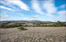
fig. 17 landscapes of Lake Ladoga.
.

fig. 18 Ladoga Lake - Coast.
.

fig. 19 Ladoga Lake - Burun.
.

fig. 20 Lake Lake - Forest.
.

fig. 21 Ladoga Lake - silence.
.

fig. 22 Ladoga Lake Autumn.
.

fig. 23 Stony lake Ladoga shores.
.

fig. 24 troty rocks, pos. Vyartsil, northern liking.
.

fig. 25 Ruskeala, a former marble quarry. The height of the cliffs: 30 - 40 m, northern lump.
.

fig. 26 Ladoga Lake - Stones.
.

fig. 27 Voton Voslitza - River in Karelia, put it.
.

fig. 28 on the islands of Lake Lake.
.

fig. 29 Cape Rahaneii. Shine on August 18, 2003.
.

fig. 30 Gorskii Headoladozhsky Channel Photo 1909
.

figure 31 Korena Fortress in Priozersk.
Korela (SC. KEXHOLM, Fin. Käkisalmi "Kukushkin Strait") - stone fortress in the city of Priozersk, on the island of Vuoksa River. Medieval Korela was the north-western city of Russia. The fortress was laid at the turn of the XIII and XIV centuries. Novgorod on the island of the riverpower(Vuoks) To protect the Northwestern Lights of the Republic from the Swedes.
Priozersk - [Karelsk. Kägöisalmi, Fin. Käkisalmi - Kukushkin Strait, Swede. KEXHOLM - Cukushkin Island] - administrative center Priozersky district of the Leningrad region. The city is located on the Karelian Isthmus, on the shores of the northern sleeves of the Vuoksa River, between Lake Lake and Lake Vuoks. Until the early XVII century, the center of the Korel Land, the Korean county of the Water Five. From the XIV century to 1611, the city is known as Korela. C 1580 to 1595 and from 1611 to 1918 the city was called Kexholm. Since 1918, the city, as part of the independence of Finland, became known as Kyakisalmi. In 1940, after the Soviet-Finnish war, the city was departed to the Soviet Union, the name Kexholm was returned. In 1941-1944, during the Soviet-Finnish war, the city was engaged in the troops of Finland and was called Kiakisalmi. In 1944, after the Moscow truce, the city immediately departed to the Soviet Union. In 1948, renamed Priozersk.)
.

fig. 32 Fortress Oreshek - Walnut Island, (Fin. Pähkinäsaari) - a small island in the origin of the Neva. Main attraction - the old Novgorod fortress of the XIV century nut.
.

figure 33 Map of the Encyclopedia of Brockhaus and Efron. Ladoga lake. (Clichable)
...
The problem of the history of the development of Lake Lake and Education r. Neva Currently, in many aspects remains a discussion. At the moment, fundamental generalizations made by teams of authors 1 leave a number of important issues requiring further scientific studies and solutions. The main ones are the time of the r. Neva and direction of runoff from Ladoga to education r. Not you.
The Ladoga Lake Basin began to fill with water as the destruction and melting of the glacier of the last Valdai glaciation. According to recent research on the problem of the deglaciation of the Ladoga and Onega Lakes, using warrochronological, radio-carbon and paleomagnetic tape clay tests, it was found that the Lake Lake was released from ice in the interval of 14,000-12500 calendar years (11800-10300 14 from years ago) ( Fig. 1).
Fig. 1. Stages of the deglaciation of the Lake Lake Ladoga
Within the Ladoga Lake Basin, there was a deep-water cold oligotrophic relegation (Fig. 2), which was the eastern Plove of the Baltic Ice Lake 2, in which a powerful stratum of lake-glacial belt clay 3 was formed for 2000 years.
 Fig. 2-a. The position of the edge of the glacier and the Baltic Ice Lake adjacent to it is 10300 14 from the years ago or 11500 calendar years ago before it is descent after the departure of the edge of the glacier from the city of Billingen in Central Sweden. The dotted line shows the current position of the Baltic Sea coastline 7.
  Fig. 2-b. Lake Lake was part of a large proportionate lake. Water levels reached 50-60m. The northern part of the Karelian Isthmus was flooded
 A characteristic feature of ribbon clay is their distinct gradation lamination. In the cuts of ribbon clays there is an alternation of layers of two genera: clay, relatively thin and painted in darker tones, and more coarse, aeuritic or sandy, high power and light-colored.
The first is called winter, second - summer layers. Ribbon clays were formed from the glacial muta - the product of the alternation of the moraine, which brought the flow of melt water into the waterial reservoir (Fig. 3).
 Fig. 3. Photo of ribbon clays, formed in the conditions of the Note Lake. One layer corresponds to one year.
 Deposition at the bottom of the lake lake a larger debris material in a spring-summer period and a more subtle material in suspension - in the autumn-winter season - led to the formation of ribbon clays. In the conditions of a cold, sharply continental climate of late glacier, the productivity of the lake and ground ecosystems was low, which was reflected in a very low content of organic matter in tape clays.
The powerful thickness of the Lake-glacial sediments of Floj will leave almost all the bottom of the Lake Ladoga, and their capacity reaches 20-30m 4. The deposits of the Baltic Ice Lake are encountered in the cuts of the bottom sediments of many lakes located in the northern lowland part of the Karelian Isthmus 5.
Above the cut ribbon clay, there is a gradual refinement of the layers up to their complete disappearance: tape-eyed clays are replaced by microsloral and homogeneous clays (Fig. 4).
 Fig. 4. A consolidated section of the bottom sediments of the Lake Lake and Paleogeographic Reconstruction 12. The change in the structure of the bottom sediments of the Lake Lake in time from glacial deposits (moraine) to lake-glacial (belt clay) and to lakes (homogeneous clays and iba) are shown. P.P.P. - Losses in calculating the samples of bottom sediments, the indicator of changes in the content of an organic matter, which in turn, in turn, by an index of the bioproductivity of the reservoir and changes in the temperature regime. The maximum content of the organic matter in bottom sediments relates to the optimum of Golocene.
 This facial transition from one type of clay to others was associated with the gradual degradation of the glacier, the retreat of its edge from the waterboance of the lake and, accordingly, with a decrease in the receipt of debris material and the deposition of a predominantly suspended substance.
According to existing ideas, the last reduction in the Baltic Ice Shield occurred unevenly, as well as the isostatic raising of the territory followed. It is believed that about 10300 14 from years ago in the area of \u200b\u200bmodern G. Billingen in Central Sweden (Fig. 2) The decay of the glacial blade led to the liberation of straits, a sharp decrease in the drainage threshold and the drop in the level of the Baltic Ice Lake (BLO), which caused the release of Under the waters of a huge territory from the Baltic to the White Sea, adjacent to the edge of the glacial shield.
The descent of Blo was catastrophic and short-term. The sea waters of the World Ocean penetrate the Baltikin, forming the solonic water conditions of the stage of the Ioldi Sea (Fig. 5). Lake Lake from this point in time is separated from the Baltic.
 Fig. 5-a. The position of the edge of the glacier and the outlines of the Ioldi Sea, connecting with the ocean through the straits in Central Sweden 13.
  Fig. 5 B. Lake Lake connected with the Ioldi Sea in the northern part of the Karelian Isthmus. The stroke lines are shown the southern border of the lakes to the Lake in the Ioldi Stage.
 The reduction in the BLO level was accompanied by strong processes of deanudition and erosion of the naked parts of the bottom, as a result of which in the cuts of the bottom sediments of most lakes of the Northern part of the Karelian Isthmus, there is a sandy as a contact of the clay and overlying ils or a sharp boundary between them, testifying to break in sedimentation. In the structure of precipitation, the lakes located within the Karelian Isthmus - the Heinoioksky Strait, which connected the Lake Lake and the Baltic Sea, are found in the sand baffles with a capacity of up to 0.5 m 6, overlapping tape clay. Above the cuts of sand baffles are overlapped with organic-mineral lake sediments (sapropeli) and swamp peat.
In early Holocene (10300-9500 years ago), due to the significant warming of the climate in the northern hemisphere, the rapid destruction of the Baltic glacial shield, the descent of the Baltic Ice Lake, and, as a result, the insulation of the lake Ladoga, there was a shift in the lake of the Lake-glacier type. sedimentation of lakes (Fig. 4). Characteristic low-power gray homogeneous clays are formed (0.2-0.8m).
In the second half of the prepeditious time there was a rise in the level of Ladoga to 18-20m marks. This was the consequence of the anti-transgression of the Baltic (Fig. 6) about 9,200 years ago, led to the binding of the runoff of the Ladoga and, as a result, to the rise of the water level in the lake (Fig. 7). During the maximum of anti-transgression, the southern shallow towns of Lake Lakes to modern will be uptown of about 20m (Fig. 6) took place.
 Fig. 6. An Anchil Stage of the Baltic Sea during the maximum of transgression associated with the closure of straits in Central Sweden due to the isostatic raising of the territories liberated from-under-ice.
  Fig. 7. Reconstruction of changes in the levels of Lake Lake and the Baltic Sea in late and postlegdnik.
 About 9500/9000 years ago, approximately at the turn of Boreala and Boreala, lake deposits are beginning to accumulate in the Ladoga of Ladoga - Yers (Fig. 4). Due to the fact that the water area of \u200b\u200bthe lake in Holocene has repeatedly decreased, the full and most powerful sediments are observed in the northern deepwater area. In the process of sedimentation, the role of organic substance of autochthonic origin increases. In ILA, an increase in the content of organic matter compared to clays is noted.
At the turn of Boreal and Boreala about 9,000 years ago, the level of Ladoga is again reduced due to the recession of the Baltic to marks below the current position, which is fixed according to the study of bottom sediments in the shallow southern part of the lake 8.
Ladoga and Baltic dismemberment occurs, the Heinoioksky strait dries, and many Lakes of the Karelian Isthmus are isolated, in which organogenic ils are formed, and peatlands are formed in the mouths of the rivers. According to different authors, the radiocarbon age of peatlands is 7870 ± 110 years in the Pitkyaranty area, 7970 ± 260 and 7960 ± 230 years at the mouth of the river, 7110 ± 170 years on the Vyun River, 6900 ± 70 years on the Olonka River 9.
The flow of the Ladoga at that time was headed through the system of the duct of the lake-river system of Vuoksa to the Vyborg Bay, and the threshold of the runoff from Ladoga was located in the area of \u200b\u200bthe modern p. Broadco (Finnish name Heinoi) at an altitude of 15.4 m above sea level.
The most interesting and discussion period in the history of Ladoga is the length of the last 5000 years. This stage that received the name of Ladoga Transgression in the literature corresponds to the interval of 5,000-3000 years ago (Fig. 8). The reasons for this transgression are interchangeable. M. Saarsno 10 The main reason has seen in the ahead of the isostatic raising of the earth's crust on the northern coast of the Finnish and Baltic Bay, as a result of which the stock of water from the Saimen System of the lakes stopped The Gulf of Finland.
As a result of the skew, there was a new threshold of the runway through the regional ridge of Manene Salpauselkia-I in the city of Imatra to the system r. Vuoksus, who at that time flowed from Ladoga to Baltic. WATER The largest Saimen Lake System of Finland, which is bombarded by the moraine Salpausselki, on the representation of M. Saarsnisto, broke through in Ladoga, dramatically increasing the parish part of the water balance of the lake.
According to A. V. Schnitnikov 11, the development of Ladoga transgression was due to the next centuries-old rhythm of fluctuations in overall moisture, which was widely manifested in this period of Golocene and could lead to a breakthrough of water from OZ. Saima and to a significant increase in the runoff in a laugh from a vast hydroide basin. Apparently, during this period, the action of several factors, endogenous and exogenous, which contributed to the essential transformations of the hydrographic network of the basin and the water balance of the Ladoga were affected.
The result of the development of Ladoga transgression, as was customary, was overflowing the ladodies through the Mginzo-Tosnensky watershed and the formation of the Neva River. Most researchers, starting with G. de Geera, Y. Isilio, E. Hyppya, in which he later referred to D. D. Kvasov 14 believed that the Nevsky duct between the lady and the Baltic was formed mainly as a result of the glossyizostatic raising of the northern lump and skew the Ladoga Basin , as a result of which the water of the lake flooded her southern part and were introduced into the valley of the r. Pra-MGU, driving in Ladoga.
They achieved the height of the Mginzo-Tosnensky watershed, represented by the Grocery (about 18m), folded by the Mary Suglink, blurred it and carried out the descent of the water of the Ladoga in the valley of the river. Pratosnas, which took place earlier in the Finnish Bay. At the same time, the lower parts of the valleys were expanded and deepened with the drain of the lady (Fig. 8).
 Fig. 8. A map showing the modern outlines of the Lake Ladoga (oblique hatching (2)) and during the maximum of the Ladoga transgression (black painting (1)) to breakthrough p. Not you.
 The time of the Ladoga transgression maximum and the beginning of the formation of the Neva River from different authors has different dates. Yu. Isilio 15 and S. A. Yakovlev 16 believed that Neva arose in the period of 4500-4000 years ago. Later, K. K. Markov with co-authors 17 pointed to the short-term Ladoga transgression, which fit into part of the subboral period. O. M. Znamenskaya et al. 18 dates it 2000 years ago, and D. D. Kvasov 19 considered it in the interval 2300-1200 years ago. According to M. Saarsnisto and T. Grenlund 20 r. Neva arose about 3100 years ago.
In the work of D. B. Malakhovsky et al. 21, new conclusions are given about the time of the Ladoga transgression and the formation of the Neva River, which are refined to dating upstands and the roof of peatlands, the underlying sediment of transgression in the context of Nevsky Forest park (3000-2800 years ago) and overlapping them in the context of the "Nevsky Piglet" (2400 years ago).
Thus, on the basis of this data, in a short period of time, about 400 years, the level of Ladoga dropped from 18 m to 5-6 m, which is quite real, given that the South Lake Water Separate was made by loose sedimentary rocks, while the North - Heinoioksky - crystalline .
As the northern part of the Karelian Isthop is heated and the HayniOksky Strait, as the lake-river-river-lines of the Priozersk - Vyborg - Vyborg, took place. During the regression of the Ancilant Lake and the continued raising and skew of the northern part of the Ladoga, the level of Ladoga and Baltika compared.
It was at this time that the new stock from the north was broken from the Siemene system of the lakes and his bifurcation arose. Partially this stock went on the old waters of the Heinoioksky Strait to the Priozer Bay, and part of the runoff continued in the Baltic. Large volume of inlentic behavisions went along the western coast of Ladoga and contributed to blocking the runoff from the palm of the Lake Sukhodolsky Lake (the former Oz. Tvuto).
We studied by the powerful sand coastal of subborne-time, with a height of more than 17 meters adjacent to glacial sediments, (the ancient RAM, stretching from the north to the south almost from Priozersk to the Pyrachka), are fixed along the West Bank of Ladoga. They were broken by water flow in 1818. in the area of \u200b\u200bmodern mouth r. Stormy (Tipole Bay).
It must be emphasized that the estimated overlapping of the runoff from Ladoga could be realized only as a result of the time-combined block movements on the Karelian covo, caused by the activation of the isostatic lifts of northern lines, an increase in moisture and a change in the direction of flow from the Synamian system. The relative lowering of the southern part of the basin could lead to a breakthrough of water from the Ladoga and the formation of p. Neva (or a significant increase in the runway in the direction of the right-Neva, if he existed to these events, i.e. there was a bifurcation of flow from the lady).
The violent river was formed as a result of a sudden water breakthrough. SUVTO (Sukhodolsky) through the man-made canal and its descent in Ladoga only in May 1818. Level Oz. Suvanuto dropped to 11m, and its bottom was exposed on the square more than 5000g. The duct arose from it to the west in the river. Vuoksus, completely dryed, a rocky pasture was formed in her place. From now on, p. Vuoksa reversed and began to fall into the laugh, and the numerous Lakes of the Karelian Isthmus sharply lowered their level and rough.
This happened as a result of a decrease in 10-11m OZ. SUVTO and other local bazis of erosion in the Vuoksus basin. Significant changes were also caused by further artificial increase in the flow rate on the r. Vuoksa - Oz. SUVTO in 1857 and the formation of Losevian ducts. This event 119 also reflected on the entire hydrographic network of the Karelian Isthmus and entailed the appropriate restructuring in the structure of its landscapes.
The numerous Lakes of the Karelian Isthmus sharply lowered their level, roughly and significantly reduced the size of the waters as a result of a decrease in local erosion bases in the r. Vuoksus. Comparison of the area of \u200b\u200bthe largest lakes on the cards of the Karelian Isthmus of the beginning of the XIX century and in 1983, shown to one scale, showed that, for example, the area of \u200b\u200bOz. Sukhodolsky decreased by 32.4%, oz. Balakhanovsky - by 59.5%, Oz. Cancer - 88.6%, dozens of small lakes completely disappeared.
Literature:
1 . Kvass, D. D. History of Ladoga, Onega, Pskov-Child, Lakes, Baikal and Khanki / D. D. Kvasov, G. M. Martinson, A. V. Raukas (Ed.). - L., 1990. - 280 s.; The evolution of natural conditions and the current state of the geosystem of Lake Ladoga: Sat. Scientific Tr. / Ed. N. N. Davydova, B. I. Koshechekina. - St. Petersburg., 1993. - 118 p.; Kvass, D. D. Post-quadructive history of large lakes and inland seas of Eastern Europe. - L., 1975. - 278 p.; Davydova, N. N. New Data on Late Pleistocene and Holocene History of Lake Ladoga / N. Davydova, V. Khomutova, M. Pushenko, D. Subetto // Report on Lake Ladoga Research in 1991-1993. Joensuu. 1994. - № 111. - P. 137-143; Subetto, D. Contribution to the LithostratiGraphy and History of Lake Ladoga / D. Subetto, N. Davydova, A. Rybalko // PalaeoWoGeography, Palaeoclimatology. Palaeoecology. - 1998. - № 140. - P. 113-119; The First International Lake Ladoga Symposium // HydrobioGy. - 1996. - Vol. 322. - 328 p.
2 . Davydova, N. N. Ladogle Pleisotocene history of Lake Lake // History of Pleistocene Lakes of the Eastern European Plain / V. I. Khomutova, N. N. Davydova, A. V. Raukas, V. A. Rumyantsev (ed.) - St. Petersburg., 1998, - P. 134-140; Kvass, D. D. Late Courted History of large lakes and inland seas of Eastern Europe. - L., 1975. -278 s.; Subetto, D., Davydova N., Rybalko A. Contribution to the LithostratiGraphy and History of Lake Ladoga / D. Subetto, N. Davydova, A. Rybalko // PalaeoGeography, Palaeoclimatology. Palaeoecology. - 1998. - № 140. - P. 113-119.
3
4 . Subetto, D. A., general characteristics bottom sediments. Lake Lake / D. A. Subetto, A. E. Rybalko, M. A. Spiridonov // History of Ladoga, Onega, Pskov-Child, Lakes, Baikal and Khanki / D. D. Kvasov, G. M. Martinson, A. V. Raukas (ed.). - L., 1990. - P. 35-42.
5 . Sevastyanov, D. V. Processes of sedimentation in the lake-marsh geosystems of the North-West Ladget / D. V. Sevastyanov, D. A. Subetto, H. A. Arslanov et al. // Izv. RGO. T. 128, vol. 5. - 1996. - P. 36-47; Sevastyanov, D. V. Features of the evolution of the lake and river network in the lake Lake Basin in Holocene / D. V. Sevastyanov, D. A. Subetto, E. D. Sikatskaya, O. E. Stechochkin // Bulletin SPbSU Ser. 7, vol. 1 (No. 7). -2001. - P. 88-100; Subetto, D. A., Davydova N.N., Wolfart B., Arslanov H.A. Lito, Bio-and Chronostratigraphy of the Lake Sefnings of the Karelian Isthmus at the boundary of the late Pleistocene-Golocene / D. A. Subetto, N. N. Davydova, B. Wolfart, H. A. Arslanov // Izvestia RGO. T. 131, vol. 5. - 1999. - P. 56-69; Subetto, D. A. Building, features and history of formation of bottom sediments // Lake Lake: Past, present, Future / V. G. Drabkov, V. A. Rumyantsev (Ed.). - St. Petersburg, 2002. - P. 122-136.
6 . Sevastyanov, D. V. Features of the evolution of the lake and river network in the lake Lake Basin in Holocene / D. V. Sevastyanov, D. A. Subetto, E. D. Sikatskaya, O. E. Stechochkin // Bulletin SPbSU Ser. 7, vol. 1 (No. 7). - 2001. - P. 88-100; Subetto, D. A. Building, features and history of formation of bottom sediments // Lake Lake: Past, present, Future / V. G. Drabkov, V. A. Rumyantsev (Ed.). - St. Petersburg, 2002. - P. 122-136.
7
8 . Kvass, D. D. History of Ladoga, Onega, Pskov-Child, Lakes, Baikal and Khanki / D. D. Kvasov, G. M. Martinson, A. V. Raukas (Ed.). - L., 1990. - 280 s.; Subetto, D. A., Davydova N.N., Wolfart B., Arslanov H.A. Lito-, bio and chronostratigraphy of lake sediments of the Karelian Isthmus at the boundary of the late Pleistocene-Golocene / D. A. Subetto, N. N. Davydova, B. Wolfart, H. A. Arslanov // News of the RGO. T. 131, vol. 5. - 1999. - P. 56-69; Subetto, D., Davydova N., Rybalko A. Contribution to the LithostratiGraphy and History of Lake Ladoga / D. Subetto, N. Davydova, A. Rybalko // PalaeoGeography, Palaeoclimatology. Palaeoecology. - 1998. - № 140. - P. 113-119.
9 . Abramova, S. A. History of Lake Lake in Holocene according to spore-pollen and diatomic analyzes / S. A. Abramova, N. N. Davydova, D. D. Kvasov // History of the North-West Lakes. / Answer ed. S. V. Calestr. - L., 1967. - P. 113-132. Koshechekin, B. I. Holocene transgression Ladoga Lake / B. I. Koshechekin, I. M. Ekman // Evolution of natural conditions and the current state of the Lake Ladoga geosystem / ed. N. N. Davydova, B. I. Koshechekina. - St. Petersburg., 1993. - P. 49-60; Subetto, D. A., Davydova N.N., Wolfart B., Arslanov H.A. Lito-, bio and chronostratigraphy of lake sediments of the Karelian Isthmus at the boundary of the late Pleistocene-Golocene / D. A. Subetto, N. N. Davydova, B. Wolfart, H. A. Arslanov // News of the RGO. T. 131, vol. 5. - 1999. - P. 56-69
10 . Saarnisto, M. The Late Weichelian and Flandrian History of the Saimaa Lake Complex. -Helsinki, 1970. - 108 p.
11 . Schnitovikov, A.V. Variability of the general humidification of the continent of the northern hemisphere. - m.; L., 1957. - 337 p. Schnitovikov, A.V. Intravena variability of components of general humidification. - L., 1969.
12 . Subetto, D. A. Building, features and history of formation of bottom sediments // Lake Lake: Past, present, Future / V. G. Drabkov, V. A. Rumyantsev (Ed.). - St. Petersburg, 2002. - P. 122-136.
13 . Bjorck, S. A Review of the History of the Baltic SEA, 13.0-8.0 KA BP // Quaternary International. - Vol. 27. - 1994. - P. 19-40.
14
15 . Ailio, J. Die Geographikche Entwicklung des Ladogasees // Fennia. - 1915. - BD. 8, No. 3. -157 p.
16 . Yakovlev, S. A. Narnos and relief of Leningrad and its surroundings. - L., 1925. Part 1. -186 p.; 1926. Part 2. - 264 p.
17 . Markov, K.K., Poretsky V.S., Yezhens V.E. On the fluctuations in the levels of Ladoga and Onega Lakes in the post-year-old time / K. K. Markov, V. S. Poretsky, V. E. Shati-on // Tr. Comit. According to studied. fourth. Period. - 1934. - T. 4. one.
18 . Znamenskaya, O. M., Sokolova V.B., Homutova V.I. Comparative analysis of the paleogeographic conditions for the development of the southern and western banks of Ladoga Lake / O. M. Znamenskaya, V. B. Sokolova, V. I. Khomutova // History of the lakes. - Vilnius, 1970. - P. 319-331.
19 . Kvass, D. D. Late Courted History of large lakes and inland seas of Eastern Europe. - L., 1975. - 278 p.
20 . Saarnisto, M. Shoreline Displacement of Lake Ladoga - New Data From Kilparalsaari / M. Saarnisto, T. Gotsnlund // Hydrobiological. - 322. - 1996. - P. 205-215.
21 . Malakhovsky, D. B. New data on the Holocene History of Ladoga Lake / D. B. Malakhovsky, H. A. Arslanov, N. A. Gay, etc. // The evolution of natural environments and the current state of the Lake Lake Geosystem / Ed. N. N. Dvalovova, B. I. Koshechekina. - St. Petersburg., 1993. - P. 61-73.
22 . Bjorck, S. A Review of the History of the Baltic SEA, 13.0-8.0 KA BP // Quaternary International. - Vol. 27. - 1994. - P. 19-40.
Lies almost in the center of the region of the Great Lakes, at an altitude of 4.95 meters above sea level, is between parallels 59 ° 51` and 61 ° 46` North latitude and meridians 29 ° 48 and 32 ° 58` Oriental longitude from Grumeric. With oval, somewhat pointed to the north form, the lake stretches almost in the meridian, in the direction of which it has the greatest length in 196.5 kilometers. The largest width of the lake is almost in the middle of the length, on the parallels of 61 ° of the northern latitude, and between the mouths of Vuoksus and Olonki, 124 kilometers.
To the north of the lake, the lake is quickly narrowed and end with the bay of Hien-Selka, and to the south of the shore, they narrow slowly and end in the extensive bays of Shlisselburg and Volkhovsky, separated by a wide protrusion. The length of the coastline is 1071 km., Of these, 460 km., Occupying part of the Western shore, from the border with the creek of the one-time to the source of the Neva, the entire southern bank and part of the eastern to the village border conjugation, owned by Russia, the remaining 610 km. owned by Finland.
The surface of the lake, with the inclusion of islands, is 15923 km2, of which 8881.1 km2 in Russia and in Finland 7041.6 km2 yielding the largest lakes and America, Lake Lake significantly exceeds all European lakes: it is twice as much, three times more Venus, Five times more and ten times more Saimensky, not to mention the rest of the Western European lakes.
Lake Lake serves as a receiver of a huge amount of waters, the only runoff of which is a multi-oiled neva, resulting from the south-western corner of the lake with two sleeves, separated by the island of Orekhov, and flowing at St. Petersburg. From the tributaries, directly flowing into Lake Ladoga, remarkable: in the western part of the lake: The Vuoksa River, arising from Saimensky Lake and forming a well-known Waterfall Imatru, flows into the Lake Lake directly from Kexholma, part through the Lake Suvanto River Taipal; In the northern part: Gellyl, Lyasc, UKSA, Tormom, and Minol; In the eastern part: Vidlitz, Toolca, Olonka, Jazh, Svir with Issue and Pasha and Voroneg; In the southern part: Locking with Tikhvinka, Volkhov, Cobon, Lava, Sheldich and the fact. The tributaries of the wolch, sozing and the swit serve the beginning of three water systems: Vysnevolotsk, Tikhvinskaya and Mariinskaya, connecting the Lake Lake with the Volga basin, each of the named rivers, together with the rest of the southern rivers, while pushing its lake, connects or intersects with old and new bypass Podcasto channels, which stretch along the entire southern and often eastern shore of the lake, from the source of Neva to the mouth of Sviri.
With the help of numerous tributaries, Lake Lake captures, except for part of Finland, St. Petersburg and Olonets, almost all the Novgorod and some parts of the Pskov, Vitebsk, Tver and Arkhangelsk regions. Ladoga pool contains space in 250280.3 km2 Although Lake Lake, being between the pool and and, occupies a very advantageous position, and in extensiveness, depth and excellent shipping conditions itself is an inland sea, but its shipping and trade and economic importance are extremely Minor, due to the bypass podoogi channels, who made a completely unnecessary building necessary for swimming in the lake of seaside vessels.

Bay, Lake Lake and Rocks (photos of Oleg Semenhenko)
Lake Ladoga coast. From the mouth of Vuoksus to the source of Neva, the shore consists of clay and sublibious nans, bounded by sandy soil, with numerous boulders. To the mouth of Taipelas coast is still quite elevated, but further to the south extends the lowland deserted coast, partly sandy, partly and covered with thick. The southern coast of the lake, between the source of the Neva and the mouth of the Sviri, the lowestly, almost flavored and consists of clay and swampy; Formed by the nanos of the rivers flowing into the lake, it is limited to the south of the sublime grocery of the silurian system limestone, which, in all likelihood, was once the shore of the Lake Ladoga. Currently, there are from it in a distance from 3 to 30 kilometers, and only near the mouth of limestone sviri with their rocky cloths are cut into a wedge in the coast of lakes, to the Storozhensky cavity, forming the outskirts of the peninsula far outstanding in the lake.
East shore, from the mouth of Sviri to Oz. Karkun-lamp, first the bold and part of the swampy, gradually towers and consists of clay and loamy soil, which goes on the coastline itself into purely sandy. The coastal of the northwestern part of the lake is a complete opposite of southeast. Here the shores and adjacent to them are elevated, rocks and consist mainly of granite, partly Gneis, Shenitis and other crystalline rocks, as well as from various kinds of marbles.
From Kexgolm to the North and further to the East to Impeilks, granite gradually moves from light gray and coarse-grained in a blue-gray and fine-grained, very strong and solid, further, to Pitkerando, goes into a reddish, south of pitcurando granite is completely hidden from the surface Earth, and the soil is sand-clay, filled with boulders of different species, and granite is found only in the lake of low-altitude capes consisting of fine-grained red granite.
Islands In terms of its composition and height correspond to the same bank in which they are located. Almost all the islands of the northern part of the lake is elevated, consist mainly of granite and solid stone rocks, meanwhile, as the islands of the southern part of the lowlands, part of the swamp and are surrounded by shamels and reefs. Due to the set of islands and significant cutoffs of the coast, the northern part of the lake is very rich from the winds of the bays and bays, representing very comfortable places for the calm parking of vessels, in the southern part of the lake of such places there are almost no everything, as a result of which the courts are strong winds, are forced to stay in open lake, mostly on the open and dangerous Skykinsky raid.
From the islands of the northern part of the lake, near the shores, the most remarkable: the island of Cook-Sari, lying at the mouth of the river Vuoksus. In the Kronoker Gulf: Kilpodan, Cappan and Teposari, of which the last two form an entrance to the bay, representing an extensive bay, completely calm for the parking of ships. Sarolin Island, which is the left bank of the Yakimvar Bay, 12 km. Retributed to the mainland and representing a safe bay with all sorts of.
From the islands in the middle of the northern part of the lake, the Valaam Group, consisting of 40 islands, which stretch in parallels, is about 20 km away. From the extreme islands of the northern schker. The main and largest of this group is the island of Valaam (26.2 km2), which has a very wrong form, but with close to it is the Skitsky, Forerid and Nikonovsky, presented in the form of an equilateral triangle. In the northwestern part of it, on the rock, there is a Valaam-Preobrazhensky monastery, in the depths of the bay, with a comfortable pier. To the east of the Valaam, the islands are drawn: Baoy and Crusades. To the southwest of the island: Gange Pa with Lighthouse, Muarka, Yala and Rahma Sari, lying almost on one parallel. Islands are south: Suri Vero-Sari and Owl or Vasia Sari. South of this last Island lies Konevets (6.5 km2), which is located Konevsky-Christmas monastery.

Lake Lake (Photo Dmitry Savina)
Depth Lake Ladoga is generally very significant; It is unevenly distributed, depending on the height of the shores: the coast adjacent to the cloud chuck and sublime, the depth is greater and vice versa. From the southern lowland coast, the depth, starting from the half-meter, slowly and gradually increases; After passing out the reefs and grieces outstanding from this shore, it begins to increase rapidly, so in the middle of the lake ranges from 60 to 110 m., in the same place, it increases to 140 to the north, and in some places it reaches 200 meters. Thus, the Ladoga bottom has a very significant bias from the south to the north, and it consists of a number of more or less incorrect ledges, in which there are significant bumps and hills, in places of deepening and brand. So, between the lines of the depths of 60 and 80 m. There are elevations of the bottom, on which the depth is only 32 m., And in the north-western part of the lake, between the lines of the depths of 10 and 140 m., There are depths of 200 or more m.
Water level and flow. The water level of the Lake Ladoga is subject to constant fluctuations, depending on the totality of all meteorological circumstances throughout the lake basin, as a result of which the height of the lake water is not only in different years, but at various times the same year is very different. Since time immemorial, the existed belief of the seven-year periodicity of changes in the water level of the lake, according to which the horizon of lake water for 7 years is constantly, it is being toward, and for the next 7 years, it is constantly falling, it was completely refuted by 14-year observations, which were produced on the island of Valaam and of which did not have any correctness in changing the position of the water level.
Opening and freezing. First of all covered thin ice The shallow southern part of the lake, usually in early November, sometimes at the end of October, at a temperature of about 5 degrees Celsius. This thin ice or fatness is introduced into the Neva, on which the autumn iceshield continued for a short time. In the same lake, with increasing frost, the ice is covered with the whole southern part of the lake, both at the very coast and in the space between the reefs outstanding from it and the flames. Next, north of the parallels of the dry light, under the influence of winds, easily breaking the formed ice, the lake does not freeze the lake, and at the large depths of the northern part freezes only in December, often in January, in the other years the middle of the winter the middle of the lake remains not frozen .
In general, the lake is covered with solid ice only in the most severe winters, with ordinary frosts ice covered only the outskirts, kilometers by 20-30 from the shores. To determine whether the middle of the lake frozen or not - it seems the case rather difficult, due to the remoteness of the middle of the lake from the coast. Fishermen, which produce treated non-aqueous fishing, determine this with a lot of accuracy of the flow in the holes: If the course is noticed in the holes, the course corresponding to the direction of the wind is noticed, then the middle of the lake remains not frozen, the lack of flow shows that all the lake is covered with solid ice.
The opening of the Lake Ladoga, like the freezing, also begins at the southern coast of the lake, usually at the end of March - the first half of April, at the same time with the opening of the southern tributaries and the profit of warm water, which has a direct impact on the opening of the Neva, which always starts from the source, Schliniselburg What two ice drifts are happening on it: the actual river, ongoing long, and very long Ladoga, almost never passing at once.
Ladoga lake It is the largest freshwater lake on the European continent. For Russia, this lake has a large industrial, environmental and historical significance. Another name of the name - Ladoga.
If you look at the map, you can see that the shores of Lake Ladoga belong to the two Russian regions: Republic of Karelia and the Leningrad region. That is, located in the European part of the country.
On the north side Ladoga The shores are high, rocky, their relief is sufficiently ruined, which explains the presence of a large number of peninsulas, bays, small islets here. From the south of Ladoga, the lake is surrounded by low gerier, smoother shores. Here are the largest bays: Volkhovskaya, Svirskaya, Shlisselburg lips. East Coast is also not different, there are found here. sand beaches. In the West coastline Almost even. There are mixed forests, bushes, near water on land, many large stones, which are also covered under water under water on a fairly far distance.
Make their waters in Ladoga lake 35 rivers, and only one follows. The largest water river - switches. What river flows from Lake Ladoga? This is the famous Neva, on which the second most important city is the city of the Russian Federation - St. Petersburg. Some rivers make water from other lakes in Ladoga, such as Onega or Ilmen.
On the lake there is a large number of islands - not less than five hundred. The largest islands Ladoga Together are Valaam archipelago. The largest single island - riekkalansaries. Also large island Is Konevets, where a famous monastery is built, as in Valaam.

Dimensions, length and depth of Ladoga
The depth of Lake Lake is uneven throughout its territory - it increases from the south to the north. The maximum indicator of the depth of Ladoga Lake is 233 m. The average figure is significantly lower - 50 m. In the north of the Lake Lake, its depth varies from 70 to 230 m, and in the south - from 20 to 70.
The Ladoga Area is 17.87 thousand square meters. km. Water volume in Lake Ladoga - 838 cubic meters. km. The length from the north to the south of the lake is 219 km, in the widest place of Ladoga stretched 125 km.
Climatic features of terrain
Lake Ladoga is moderate in the main climate. In the geographic location where the Lake Lake is located, there are not so many sunlight during the year. Therefore, evaporation of water from the palga is quite slow. The greatest part of the year here is cloudy, overcast.
In the period from the end of May to mid-July on Ladoga Lake You can observe the famous phenomenon of "White Nights", when at night the sun practically does not go beyond the horizon.
Throughout the year, Western, as well as the southwestern direction of the winds blow in Ladoga. In winter, Lake Ladoga freezes to the end of spring, but completely covered with ice only in the coldest winter. Such a long glaciation affects the temperature of the water throughout the rest of the year. average temperature Water here is low: at a depth, it holds 4 ° C, and on the surface Ladoga Lake Depending on the time of year and the site may be in the range from 2 ° C to 24 ° C. Water is not so transparent as on Baikal, but this may be due to the fact that there are many types of algae, small plankton, as well as constant storms worry its surface, whipping the foam.

History of Ladoga Lake
Lake Lake was formed as a result of the melting of glaciers and for several thousand years its outlines were formed, changed.
Until the XIII century, the lake was called Nevo, which, apparently, was directly related to the name of the Neva River. Then it was called Ladoga Lake, having undergone the name from the city of Ladoga located here. Many objects in this area have names originating from the Karelian language. But the most likely explanation of the name "Ladoga" is the Finnish versions - from ancient words denoting water or the concept of "lower", which are consonant with Ladoga. The name of Nevo also has Finnish roots and may designate "swamp". It is possible that in those days the lake gave rise to himself, in this area there are many traces of swamps.
In Ladoga, the lake, starting from the IX century from Scandinavia, through the territory of Europe, the Water part of the path "from Varyag in the Greeks" took place through the territory of Europe. In the VIII century, the city of Ladoga was erected here, soon the other cities and fortresses began to appear here. At the end of the XIV century, the famous Valaam monastery on the islands of the same name was founded, so far its buildings are pearl of wooden architecture.
For many years, the war was with a Swedish state for the part of the lands lying on the lake. Peter I managed to achieve the fact that Ladoga became Russian. In 1721, under the contract with the Swedes concluded after the war, the Ladoga coast of the Lake Lake was found to Russia.
To make shipping on Ladog more accessible, a channel was built here.
In the difficult war years from 1939 to 1944 Ladoga Ladoga Ladoga Flotilla was based, leading fights in his waters. In 1941-1944 More than half of the coast of Lake Lake was occupied by enemy troops. From September 1941 to March 1943 on Ice, the Ladoga was held "Road of Life" - the only way for which in blood Leningrad It was possible to deliver the provisions and necessary things. Also, it was organized by the export of people, about 1.3 million people took advantage of the evacuation.
Thus, Ladoga is a lake, which is of particular importance for Russian history.
Ecology of Ladoga Lake
Basically, the lands are very clean, but there are problem areas. This is largely due to the development of industrial areas next to Ladoga lake, as well as with the consequences of World War II. During the war in this area and on some islands there were testing of radioactive weapons. Including the reaction of animals on the consequences of its use. In addition, many sunken military vessels, ammunition airplanes create an adverse radiation background.
The number of pollution places is growing. At the shores of Ladoga, approximately 600 industrial designs, which pollute the air, discard production waste to the River Ladoga and others, which then bring them to the lake. By the way, the right answer to the question is Ladoga - this is the river or lake, it will be that it is both. There is a river, and also a city with such a name. At the same time, historians claim that first the name was received by the river, then the city and only after that the lake of Nevo was renamed.
Pollution of Lake Ladoga today is considered to be at a moderate level. In some places there is an excess of radiation norms - where the tests used earlier, as well as the most close to nuclear and other industrial enterprises.

Nature and animal world of Lake Ladoga
The nature of Ladoga Lake is very beautiful, this place is very famous for tourists, travelers a place of recreation and holding campaigns. Majestic rocks, mountains, pine forests - it all creates a unique image of this place. Rare plants and animals are found in various latown reserves. Despite the difficult climate, even some southern species of plants grow here, and in the north - typical representatives of the tundra (camneur). The forests on the lake of Ladoga are not only coniferous, but also broadcaming - with maples, knitting.
Fauna Ladoga Lake Includes taiga representatives: foxes, wolves, hares, bears, etc. There is also an original animal that is only here - Ladoga Nerpe. Characteristic more for the seas Animal feels great in freshwater Ladoga.
At approximately 50 species of fish in Lake Ladoga. The most popular in fishermen and industrialists can be called a born, pike perch.
Holidays in Lake Ladoga
Around the lake Ladoga can find places to relax for every taste for any purpose: wellness, hiking, entertainment. Often you can meet fishing lovers. All that is needed for such activities is located on the recreation bases, including almost each of them work instructors who will teach the intricacies of a particular type of pastime.
Here they love to do diving because of a large number of finds, which can be found at the bottom and just beautiful underwater species. You can also choose calm rest On the beach, when weather conditions allow.
Excursions for the natural and historical sights of Ladoga are also organized, for example, remaining after the war structures, old fortresses or mountain sorts.
Lake Ladoga Attractions
The attractions of Lake Ladoga are worth talking separately. Here is, for example, interesting, with beautiful species Almost untouched nature, the Lowervirsky Reserve. It dwells a huge number of bird species and many animals.
Valaam Island at Ladoga with the monastery of the monastery represents historical, cultural and architectural value. Not to mention the fact that pilgrims come here from all over Russia and not only.
The memorial complex dedicated to the road of life tells the history of the heroic feat of people, in the most dangerous conditions of travel on the ice of Lake Lake, risking to fall under the ice or be fired by the enemy. Yet they walked to it to save the lives of residents of the city survived by a terrible blockade.
Also historical and cultural interest in Lake Ladoga are found by Peter I Cities Shlisselburg, with the fortress of nuts, the new Ladoga.
Lake Lake in artwork
Ladoga is a lake that affected the folk legends and samples of the folk art of various peoples who lived here. These are mainly Karelian and Russian epos.
The famous Karelian folk essay "Kalevala", which once passed from the mouth to the mouth, describes the events that occurred in the north of Lake Ladoga.
Konstantin Roerich in his youth made an expedition on the rivers flowing into the Lake Ladoga and to the Lake himself. From 1916, he lived in this area for two years, created several cave rooms here, sketches, poems and fairy tales.
Thanks to amazing nature Lake Ladoga inspired primarily the painters who admired the local paints, landscapes. Many wrote the Valaam monastery, as its structures looked especially effectively and mysteriously against the background of the majestic nature. The lake with the sonorous name of Ladoga also imposed fabulous stories. There were such masters of painting as F. A. Vasilyev, A. I. Kuinji, N. K. Rerich, I. I. Shishkin.

Industry on the lake
The lake is used to pass vessels, the routes of which they are segments of the Volga-Baltic path and the Belomorsko-Baltic Channel. Weather on the lake is very changed and often ships threaten storms, high waves, so periodically shipping suspend. Once even the expression was spread that if the sailor did not swim along the lag, he is still not a real sailor. Such a phenomenon like a full calm is quite rarely found on this lake.
In Ladoga, the lake transport various industrial goods, building materials. Also here are passenger ships and cruise linersFor the most part these are tourist routes.
In an industrial scale, approximately 10 species of fish are caught here, such as Koryushka, Sudak, Sig. Not far from the lake there are industrial enterprises: a paper-cellulose plant, aluminum, oil and chemical production and so on.
Secrets and secrets that keep the bottom of the Lake Ladoga
At the bottom of the lake there is a lot of interest to researchers and lovers of various secrets and secrets of things. Of course, the greatest luck is considered to find something very ancient, related to the Vikings. But the most often find artifacts that remained since the Second World War. They are better preserved, it's easier to find them. For example, the attractions of the time attracting extreme tourists and divers include the so-called "death bay", the bottom of which is practically covered with sleeves, since in 1941 a fierce fight took place.
Lovers divers find sunken ships, military time aircraft. Unlike sea, fresh water does not destroy so much and spoils sunken things, so the finds of Lake Ladoga are so attractive.
Lake Lake (has the second name of Ladoga, was previously called as unbearable) is considered the largest freshwater reservoir in Russia. Ladoga in its popularity is only a little inferior to Baikal, known throughout the world. Hundreds of tourists come to his coast every year to enjoy wonderful views and capture the beauty of these places in memory.
In this article, you will learn the main features of this reservoir - where it is located, what characteristics it has, which surrounds the lake, what is the flora and fauna, what it is in winter and summer periods.
Lake Lake belongs to two territories - East and North Coast are located in the Republic of Karelia, and the South and West delights residents of the Leningrad Region. The lake belongs to the pools Atlantic Ocean And the Baltic Sea.
Characteristics
Lake Square

If you take the total area of \u200b\u200bLadoga, then the impressive figure is 17,870 km², and even take into account the islands, then 18,320 km². The volume of water in the lake is 838 km³. The maximum fixed width is 125 kilometers, and the shared coastal length is as much as 1570 kilometers.

The height above sea level is only 4.8 meters, but the depth is ten more. It is impossible to measure the depth all over the lake, it is uneven - in the northern part of the spread in numbers from 70 to 220 meters, in South - from 19 to 70 meters. But the greatest depth was measured, in the lake Ladoga it is 230 meters.
Water temperature
Like the entire Leningrad region, Lake Lake stays in a cold rainy haze all year round. The average temperature of the water during the warm periods of the year is about +19. In the fall, it descends to +10 degrees, and in winter frosts up to -3 degrees. In August, if the year was turned out to be successful, the temperature of +24 degrees can be caught on the surface of the lake, but it will be closer to the bottom to be only +17 degrees. At a depth of more than 200 meters, the water temperature is almost always equal to +3, +4.
Nature Ladoga

Northern I. east coast (Karelia) refers to the zone of average taiga, and part of the lake in the Leningrad region - to the subzone of South Taiga. For the northern subzones, the appearance of mosses and shrubs (mostly blueberries, blueberries), the abundance of Elnikov; For the southern part there are darkened forests, sometimes linden and maple is found, but the moss cover is weaker.
In Ladoga, scientists have more than 110 species of aquatic plants. There are one of the subspecies of blue-green algae grow more than 76, and there are also green algae and diatoms. Together with the riot underwater world, we found our refuge and plankton animals. In the lake there are branched wearlute wraps, provicrats, daphnia, cyclops, water mites, a wide variety of worms, mollusks and other crustaceans.

The rich water of Ladoga is not only ticks and unicellular organisms, more than 50 species of fish are found. For example, Ladoga slingshot, trout, siga, salmon, bream, born, red-barrel, pike perch, catfish, raw, horse, pillow, roach, perch, pike, sturgeon, guster, lime and many others. The richer area of \u200b\u200bthe sea is a shallow-water southern zone, where the depth is only 20 meters. But in the northern deep-sea district, the catch will be less diverse.
In addition to fish, this reservoir can demonstrate to tourists more than 200 species of birds. The most attractive place to stay feathers - the southern zone, however, and in Karelia, you can see many birds. In the territory of Ladoga, the lake meet: seagulls, river ducks, geese, swans, cranes and wrenches, fibilies, cobwebs, marsh owls, skops, cobschiki, herbalists, golden rzhanks and even an orlan-white-tailed.

Lake Lake has become a place of habitat for the world's unique representative of the laston-legged - Ladoga ringed nerve (a special subspecies of the collected nerve). In total, they are about 4,000 in the world, so these animals are listed in the Red Book and are strictly protected by law.
Cities
On the shores of the lake, the following cities are located: Priozersk, New Ladoga, Sortavala, Shlisselburg, Pitkyaranta and Lachdenpools. The largest of them are Priozersk and the new Ladoga, although the number of man there does not exceed the bar in 50 thousand.

Near the Ladoga Lake houses the cities are larger, for example, St. Petersburg. From the northern capital of Russia to get to Lake Ladoga can be in various ways, starting from public transport (Electrics, buses, trains, ferries) and ending with moving by car. At the same time, the time on the way will be not more than three hours, and if you use the machine and put the right route on the map, then you can manage it for one and a half.

From the northern part of the nearest city to Ladoga - Petrozavodsk. From there can also be reached by car or by public transport. However, the road will have to spend a little more than 4 hours.
Climate and seasons of Ladoga Lake
For avid tourists it is no secret that in the autumn and winter months of Ladoga looks extremely intense. Even in Karelia, where the picturesque rocks and wildflowers are circle, making their way among thick herbs, Lake Lake is index.

In the cold periods on the lake there is an arctic anticyclone, which carries the strengths of wind, storm, protracted rains and a minus temperature of the air. In October, the storms season begins, it becomes raw and wet, the lake appears frequent fog. The only inventious for lovers of autumn recreation is September, this month of Ladoga is more or less ready to share beauty - torrential rains come not often, the water is calm and cleaned, the air saves the summer part of the summer.
In the summer, the reservoir kindly welcomes the guests of the southern anticyclone, pleases with picturesque places and transparent water. Only hardened people can swim here, but everyone will enjoy beauty. The average air temperature in July and August turns over the mark of +20 degrees, so tourists will definitely be able to capture the sun glare playing on the surface of the Ladoga.