Interesting places to visit. Ten places you definitely need to visit (34 photos)
We are incredibly lucky to be born in a country with unique nature. The beauty of Russia lies in its picturesque forests, lakes, gorges and mountains. All this splendor surrounds us, giving us beauty that needs to be admired and protected. When planning to travel abroad, remember what beauties our homeland has and think about whether it’s worth leaving its borders, because there are many wonderful places in Russia that will amaze you with their nature just as much as foreign countries. To make sure of this, we invite you to take a look at some of the most picturesque places in our vast homeland, which are worth visiting at least once in your life!
Volcanoes of Kamchatka
In total there are several hundred of them on the peninsula, and 29 are active. Klyuchevskaya Sopka is the highest among them (4750 m above sea level, the leader among Asian volcanoes) and the most active
Chara Sands

Since 2010 they have been included in the list of Seven Wonders of Transbaikalia
Geysers of Kamchatka

The Valley of Geysers is one of the largest geyser fields in the world and the only one in Eurasia. In 2008, the Valley of Geysers was included in the list of seven wonders of Russia
The Yakut village of Oymyakon is the coldest settlement in the world

True, sometimes it gives way to Yakut Verkhoyansk, but in any case, the recorded temperature minimums here are below -60 °C, and the usual January temperatures are -50 °C
Neighborhoods of Oymyakon

The lowest temperature in the history of the village was –71.2 °C
The Sea of Azov is the shallowest sea in the world

Its maximum depth does not exceed 13 m with average values of about 7 m
Salt Lake Elton

The largest mineral lake in Europe and one of the most mineralized in the world
Vasyugan swamps are one of the largest in the world

Their area is 53,000 km², which is larger than the area of Switzerland (41,000 km²), Holland (41,500 km²) or Belgium (30,500 km²)
Lake Baikal

The most deep lake on Earth, its maximum depth, established in 1983, is 1642 m
Kizhi

The architectural ensemble of the Kizhi Pogost has been included in the UNESCO World Heritage List since 1990
Church of the Transfiguration of the Lord (1714) - the most outstanding building of the ensemble

The church frame was cut in the traditions of Russian carpentry - without nails. Although, when they say that the church was built without nails, they are mistaken: there are nails - in the domes
Lena Pillars - many kilometers long, intricately rugged ridges of rocks stretching along the Lena River

Since 2012 included in the UNESCO World Heritage List
Nalychevo Park in Kamchatka

One of largest places With thermal springs, on an area of 287,000 hectares there are more than 200 of them
The Trans-Siberian Railway is the longest railway in the world (9288.2 km)

Starting point: Moscow-Pasazhirskaya-Yaroslavskaya station. Final point: Vladivostok station
Kutkhiny Bati

A natural monument, a bizarre outcrop of pumice four kilometers from the source of the Ozernaya River (Lake Kurilskoe). Kronotsky State Reserve, Kamchatka
Salt mine in Yekaterinburg

The unique patterns are layers of carnallite, a mineral used in fertilizer production. As a rule, it has a yellow, white or terracotta tint, but sometimes blue or even colorless is found
Curonian Spit, Kaliningrad region

Dancing forest on the Curonian Spit

In Russia there is the largest forest on the planet - the Siberian taiga

Northern lights in taiga

Uchar Waterfall

Uchar (Big Chulchinsky) waterfall in Altai is the youngest waterfall in the world. They learned about it only 35 years ago
The city of Sviyazhsk in Tatarstan

The island city with the help of which Ivan the Terrible conquered Kazan. There is no traffic here, and a good part of the territory is occupied by monasteries
Diamond quarry in Mirny visible from space

Its depth of 525 m and diameter of 1200 m made it one of the largest quarries in the world
Tundra

We present the most Beautiful places of our country, which should be seen not only by every photographer and traveler, but also by every resident of our vast Russia. Read our material and you will see: we all have something to be proud of!
Natural parks, reserves
Lena Pillars, Yakutia
Lena Pillars is a natural park in Russia, located on the banks of the Lena River in the Khangalassky ulus of Yakutia, 104 km from the city of Pokrovsk. Stretching for many kilometers, the complex of vertically elongated rocks, intricately piled up along the banks of the Lena, cutting through the Prilenskoye Plateau with a deep valley, never ceases to attract photographers and travelers. The pillars reach their greatest density between the villages of Petrovskoye and Tit-Ary.
The height of the rock formations reaches 100 meters. Scientists believe that the formation of rocks began 560–540 million years ago, and the formation of the Lena Pillars as a landform began about 400 thousand years ago.
Natural Park“Lena Pillars” was organized on the basis of the decree of the President of the Republic of Sakha (Yakutia) dated August 16, 1994 No. 837 and the government decree of February 10, 1995 and is subordinate to the regional Ministry of Nature Protection. The area of the park is 485 thousand hectares, the park consists of two branches - “Stolby” and “Sinsky”.
Valley of Geysers, Kamchatka

The Valley of Geysers, one of the largest geyser fields in the world and the only one in Eurasia, is located in Kamchatka in the Kronotsky State biosphere reserve, which is on the UNESCO World Heritage List as part of the natural complex “Volcanoes of Kamchatka”.
The valley is a deep canyon of the Geysernaya River, on the sides of which there is an area of about 6 square meters. km there are numerous outlets of geysers, hot springs, mud pots, thermal areas, waterfalls and lakes. In this territory there is an abnormally high biodiversity and a high contrast of natural conditions and microclimate. The ecosystem of the Valley of Geysers is unique throughout the country. The territory of the valley is protected by a reserve regime.
Since 1992, under an agreement with the reserve, helicopter excursions have been organized here, and there is a strict system of rules for organizing excursions in order to maintain the balance of the ecosystem. In 2008, based on voting results, the Valley of Geysers was included in the list of seven wonders of Russia.
Weathering pillars, Komi Republic

Weathering pillars (Mansi logs) are a geological monument located in the Troitsko-Pechora region of the Komi Republic on the territory of the Pechora-Ilych Nature Reserve on Mount Man-Pupu-ner (“Small Mountain of Idols” translated from the Mansi language), in the interfluve of the Ichotlyaga and Pechora rivers . With this extraordinary place There are many legends associated with it. The pillars are considered one of the seven wonders of Russia.
The weathering pillars are located quite far from inhabited places. Reaching them is in some sense a feat. To do this, by the way, you need to obtain a pass from the administration of the reserve. From the Sverdlovsk region and Perm region there is walking route, from the Komi Republic side - automobile, water and walking routes.
About 200 million years ago, there were high mountains in place of the stone pillars. Rain, snow, wind, frost and heat gradually destroyed the mountains, and especially weak rocks. Hard sericite-quartzite shales were less destroyed and have survived to this day, while soft rocks were destroyed by weathering and carried by water and wind into relief depressions.
One pillar, 34 m high, stands somewhat apart from the others. Six others lined up at the edge of the cliff. The pillars have bizarre outlines and, depending on the place of inspection, resemble either the figure of a huge man, or the head of a horse or ram. It’s true: this place is ideal for a photographer’s imagination! In past times, the Mansi deified grandiose stone sculptures and worshiped them, but climbing Manpupuner was considered the greatest sin.
Curonian Spit, Kaliningrad region

Curonian Spit- sand spit located on the coast Baltic Sea and the Curonian Lagoon. It is a narrow and long saber-shaped strip of land separating the Curonian Lagoon from the Baltic Sea and stretching from the city of Zelenogradsk in the Kaliningrad region to the city of Klaipeda (Smiltyne) (Lithuania). The name of the spit comes from the name of the ancient Curonian tribes who lived here before the colonization of Prussia by the Germans.
The length is 98 kilometers, the width ranges from 400 meters (in the area of the village of Lesnoy) to 3.8 kilometers (in the area of \u200b\u200bCape Bulviko, just north of Nida).
The Curonian Spit is a unique natural-anthropogenic landscape and a territory of exceptional aesthetic value: the Curonian Spit is the largest sand body, included, along with the Hel and Vistula, in the Baltic complex of sand spits, which has no analogues in the world. The high level of biological diversity due to the combination of different landscapes - from desert (dunes) to tundra (raised bog) - provides insight into important and long-term ecological and biological processes in evolution.
The most significant element of the spit's relief is a continuous strip of white sand dunes 0.3 - 1 km wide, some of them approaching the highest in the world (up to 68 m). Thanks to his geographical location and oriented from northeast to southwest, it serves as a corridor for migratory birds of many species flying from the northwestern regions of Russia, Finland and the Baltic countries to the countries of Central and Southern Europe. Every year in spring and autumn, from 10 to 20 million birds fly over the spit, a significant part of which stop here to rest and feed.
Favorable climatic conditions allow you to relax on the Curonian Spit from May to November. In 2000, the Curonian Spit was included in the UNESCO World Heritage List.
Nature reserve "Stolby". Krasnoyarsk region

The reserve is located on the northwestern spurs of the Eastern Sayan Mountains, bordering the Central Siberian Plateau. The natural boundaries of the protected area are the right tributaries of the river. Yenisei: in the northeast - the Bazaikha river, in the south and southwest - the Mana and Bolshaya Slizneva rivers. From the northeast, the territory borders the city of Krasnoyarsk; the border of the reserve can be reached by bus. The reserve was founded in 1925 on the initiative of city residents to preserve natural complexes around the picturesque syenite outcrops - “pillars”. Currently, its area is 47,219 hectares. Submitted to the UNESCO World Heritage List.
Lakes
Lake Baikal, Eastern Siberia

It’s unlikely that Baikal needs any descriptions, but still... Baikal is the deepest lake on the planet, the largest natural reservoir fresh water. The lake and coastal areas are distinguished by a unique diversity of flora and fauna. Local residents and many in Russia traditionally call Baikal the sea.
Meaning maximum depth lake - 1642 m - was established in 1983 by L. G. Kolotilo and A. I. Sulimov during hydrographic work. The average depth of the lake is also very large - 744.4 m. Besides Baikal, only two lakes on Earth have a depth of more than 1000 meters: Tanganyika (1470 m) and the Caspian Sea (1025 m). One of the visiting cards of Russia, a place that you need to see with your own eyes at least once in your life!
Lake Seliger, Tver and Novgorod regions

Another place that needs no introduction. By the way, Seliger has another name - Ostashkovskoye Lake, after the name of the city of Ostashkov, located on the lake shore. The area of the lake is 260 sq. km, including about 38 sq. km. km there are islands (there are more than 160 of them on Seliger). The largest among them is Khachin Island. The area of the entire pool is 2275 sq. km.
Seliger receives 110 tributaries. The largest are the Krapivenka, Soroga and Seremukha rivers. Only one river, Selizharovka, flows out of it. The lake lies at an altitude of 205 meters above sea level and is of glacial origin. This explains its peculiar shape - it is not a lake in the usual concept, but rather a chain of lakes stretching from north to south for 100 km and connected by short narrow channels. The coastline, more than 500 km long, is rugged - forested headlands, deep picturesque bays jutting into the land, and islands of various shapes.
The water in Seliger is clear, transparency reaches 5 meters. On the shore of the southern part of Lake Seliger are the city of Ostashkov and the New Yeltsy estate.
Lake Kezenoy-am, Chechen Republic

Kezenoy-am is a lake on the border of the Vedeno region of the Chechen Republic and the Botlikh region of Dagestan. This is the largest and deepest lake in the North Caucasus, located at an altitude of more than 1800 meters above sea level. The surface of the lake is 2.4 sq. km.
The depth of the lake reaches 74 m. The length of the lake from north to south is 2 kilometers, and from west to east - 2.7 kilometers. The maximum width is 735 meters. The length of the coastline is 10 kilometers.
Lake Baskunchak
Akhtubinsky district, Astrakhan region

Baskunchak is a salt lake with an area of about 115 square meters. km in Akhtubinsky district Astrakhan region, approximately 270 km north of the Caspian Sea, and 53 km east of the Volga. Lake Baskunchak is part of a unique natural complex that includes Mount Big Bogdo. In 1997, the Bogdinsko-Baskunchaksky natural complex was declared a reserve (Bogdinsko-Baskunchaksky Nature Reserve), where a special environmental regime was established on an area of 53.7 thousand hectares.
On the coast of the lake there are deposits of medicinal clays. In June-August, tourists come to the lake to bathe in brine and take mud baths. There is no need to talk about the beauty of these places. There are no fewer photographers here than people who want to improve their health.
Jack London Lake, Magadan Region

Located in the upper reaches of the Kolyma River in the Yagodninsky district of the Magadan region, it lies among the mountains, at an altitude of 803 meters, the length of the lake in the northwest direction is 10 kilometers, depth is 50 meters.
There are many small lakes around Jack London Lake. The most prominent lakes in size are lakes Mechta, Anemone, Gray Chaika, Nevidimka, Neighboring, and Kudinovskie lakes. One of the most beautiful and exotic lakes Far East. Old-timers say that the lake got its name thanks to an unusual find made by the “discoverers”. When the lake was discovered, researchers found Jack London's book "Martin Eden" on the shore.
Lake Elton, Volgograd region

Elton is a salty, drainless, self-sedating lake in the Pallasovsky district of the Volgograd region, located near the border with Kazakhstan. It is considered the largest mineral lake in Europe and one of the most mineralized in the world. They say that the name of the lake comes from the Mongolian word “Altyn-Nor” - “golden bottom”.
Lake area - 152 sq. km. Until 1882, salt was mined on Elton; in 1910, the Elton medical sanatorium was founded on its shores (moved to a new location in 1945). In 2001, the lake and the adjacent territories of virgin steppes (106 thousand hectares) became part of the State Institution “Eltonsky Natural Park”.
Blue Lakes. Cherek-Balkarian Gorge, Kabardino-Balkaria

A group of five karst lakes in the Cherek region of Kabardino-Balkaria is located at the foot of the rocky ridge from where the Cherek-Balkarian gorge begins. Located at the entrance to the gorge, Blue Lake is a unique natural phenomenon, interesting not only for Kabardino-Balkaria, but also on a national scale. The Lower Blue Lake has several names: Chirik-kel (bulk) - rotten (smelly) lake; Sherej-ana (kab.) - Cherek’s mother; Psykhurey (kab.) - round water (lake), natural artesian well.
The uniqueness of Nizhny blue lake is that with a relatively small surface (only 235×130 m), its depth reaches 258 meters. The surface water temperature in winter and summer is about +9 degrees. Not a single stream or river flows into the lake, but about 70 million liters flow out every day. The lake level remains unchanged, which is explained by powerful underwater sources. The blue color of the water is due to the presence of hydrogen sulfide and the refraction of light rays in the deep pool.
The nature here is quite picturesque: green hills, dense beech forests on steep slopes, and in the distance, in the blue haze, peaks sparkling in the sun. Closer to Babugent the greenery becomes brighter and juicier. Near the village of Babugent there is a fork in the road. At the beginning of the road to the lake in the rock there is a cave in which traces of an ancient parking lots V-X centuries AD. Now many bats live there, and sometimes, in bad weather, shepherds with flocks of sheep take shelter.
Seydozero, Kola Peninsula, Murmansk region

Lake in the Lovozero tundra on Kola Peninsula. "Seid" translated from the Sami language means "sacred". The lake is located at an altitude of 189 m above sea level. The length of Seydozero is 8 km, width is from 1.5 to 2.5 km.
According to a number of science fiction writers and ufologists, it is one of the supposed places of existence of the Hyperborean civilization. Seekers of the unknown have been exploring these places since 1922.
Lake (reservoir) Zyuratkul. Chelyabinsk region

Zyuratkul is located in Satka district Chelyabinsk region on the territory of the national park of the same name. One of the highest (724 m above sea level) reservoirs in the Southern Urals. The reservoir is surrounded by mountain ranges covered with dark coniferous forests. To the southwest is the Nurgush ridge - the highest ridge in the Chelyabinsk region. The main river feeding the reservoir is the Bolshoi Kyl. Near the source of the Satka River and the dam there is the small village of Zyuratkul, connected by bus to the city of Satka.
Previously, Zyuratkul was a natural lake. Now it is a reservoir formed by a dam built on Bolshaya Satka. A giant geoglyph was found in the lake area. About forty stone tools made of quartzite were also discovered. The technique of stone chipping makes it possible to date the tools to the Neolithic and Chalcolithic (VI-III millennium BC). Researchers are still inclined to the Copper-Stone Age (IV-III millennium BC). It is noted that at that time Southern Urals there were practically no forests (they appeared only 2,500 years ago), so the figure was easy to construct and then view from the neighboring ridge until it was covered with a layer of soil.
Until the winter of 2012, another popular attraction was located on the shore of Lake Zyuratkul - Whale Pier, which was also called the “Ural Disneyland”. But in the fall of 2012, by court order, it was demolished.
Mountains and volcanoes
Elbrus, Kabardino-Balkaria

Elbrus is a stratovolcano located on the border of the republics of Kabardino-Balkaria and Karachay-Cherkessia. Elbrus is located north of Bolshoy Caucasian ridge and is the highest peak in Russia. Considering that the border between Europe and Asia is ambiguous, Elbrus is often also called the highest European mountain peak, thereby classifying it as one of the “Seven Summits”.
The height of the western peak is 5642 m, the eastern one is 5621 m. The gorges of Adylsu, Shkheldy, Adyrsu, the Donguz-Oruna and Ushba massifs are very popular among climbers and mountain tourists. Elbrus region is the most popular ski resort in Russia. The total area of Elbrus glaciers is 134.5 square meters. km. The most famous of them: Big and Small Azau, Terskol.
Altai Mountains

The Altai Mountains represent a complex system of the highest ridges in Siberia, separated by deep river valleys and vast intramountain and intermountain basins. A mountain system at the junction of the borders of Russia, Mongolia, China and Kazakhstan. It is divided into Southern Altai(Southwestern), Southeastern Altai and Eastern Altai, Central Altai, Northern and Northeastern Altai, Northwestern Altai.
The Altai, Katunsky reserves and the Ukok plateau together form the UNESCO World Heritage Site “Altai - Golden Mountains”. Thousands of tourists come to Altai. This is a favorite place for photo tours and independent trips.
Divnogorye plateau, Liskinsky district, Voronezh region

“Divnogorye” is a hill and museum-reserve in the Liskinsky district of the Voronezh region of Russia. It is located 10 km west of the center of the region on the right bank of the Don River and 80 km south of Voronezh. The museum here was founded in 1988, and in 1991 it received the status of a museum-reserve. Currently, the museum-reserve is one of the most popular and most recognizable attractions in the Voronezh region. Every season, from May to October, it is visited by more than 60 thousand tourists.
The area of the museum-reserve is more than 11 sq. km. The maximum height of the plateau above sea level reaches 181 meters, relative - 103 meters (the mouth of the Tikhaya Sosna River at the confluence with the Don, which flows at the foot of the plateau, is located at an altitude of 78 m above sea level).
Dombay-Ulgen, Karachay-Cherkess Republic

Dombay-Ulgen is the top of the western part of the Watershed Range of the Greater Caucasus (on the border of Abkhazia and the Karachay-Cherkess Republic). Dombay-Ulgen is the highest peak in Abkhazia, located east of the village of Dombay, has three peaks: western (4036 m), main (4046 m) and eastern (3950 m).
A steep ridge extends from the main peak to the north, ending in a depression - the “Dombay saddle”. From the Dombay saddle there is a classic route (category 3B), which can be climbed in one day with a descent to the camp.
Putorana Plateau, Krasnoyarsk Territory

The Putorana Plateau is a mountain range located in the north-west of the Central Siberian Plateau. In the north and west, the plateau ends with a steep ledge (800 m or more), while the southern and eastern parts are characterized by gentle slopes. The maximum height of the plateau is 1701 m, among the highest peaks are Mount Kamen (1701 m), Kholokit (1542 m), Kotuyskaya (1510 m). In the north, the Putorana Plateau borders the Taimyr Peninsula. The name Putorana translated from Evenki means “lakes with steep banks.”
The area of the plateau is 250 thousand sq. km, which is comparable to the territory of Great Britain. On the territory of the plateau is the Putorana State nature reserve, recognized by UNESCO as a World Heritage Site.
Marble Canyon Ruskeala, Republic of Karelia, Ruskeala village

Mountain Park "Ruskeala" is a tourist complex located in the Sortavala region of the Republic of Karelia, near the village of Ruskeala. The main object of the complex is a former marble quarry filled with groundwater.
The quarries discovered by Pastor Alopeus began to be developed at the beginning of the reign of Catherine II. The first developments were led by Captain Kozhin, who was advised by Italian specialists. Today, the length of the quarry from north to south is 460 meters, the width is up to 100 meters. The distance from the highest point of the quarry side to its bottom is over 50 meters. Water transparency reaches 15-18 meters.
Ruskeala marble was used in the construction of the most beautiful and significant buildings of St. Petersburg and its palace suburbs. It covered St. Isaac's Cathedral, laid out the floors of the Kazan Cathedral, made the window sills of the Hermitage, framed the windows of the Marble Palace and the facade of the Mikhailovsky Castle, as well as the underground halls of the Primorskaya and Ladozhskaya metro stations of the St. Petersburg metro. In 2010, a significant part of the filming of the film “The Dark World” took place in Ruskeala.
Eastern and Western Sayans. Eastern Siberia

Eastern and Western Sayans - common name for two mountain systems in southern Siberia. There are Western Sayan (length 650 km, height up to 3971 m - Mount Mongun-Taiga, which is the top of the ridge of the same name - highest peak Eastern Siberia, however, more often this ridge is not classified as the Sayan Mountains, but is classified as a separate mountain system- Tuva Mountains), consisting of leveled and pointed ridges, on which there is no glaciation, separated by intermountain basins, and the Eastern Sayan (length about 1000 km, height up to 3491 m - Mount Munku-Sardyk) with typical mid-mountain ridges bearing glaciers. The rivers belong to the Yenisei basin. The slopes are dominated by mountain taiga, turning into mountain tundra.
The Western Sayan borders Altai in its southwestern part. Main Ridge its - the Watershed Sayan Range with its highest point - Mount Kyzyl-Taiga (3121 m). The Western Sayan ridges are characterized by steep slopes, rugged terrain, and vast areas of stone placers. The height of the ridges in the west does not exceed 2500-3000 m, to the east it decreases to 2000 m.
The Eastern Sayan stretches almost at right angles to the Western Sayan. Its ridges form a system of “Belogory” (Manskoye, Kanskoye) and “belkov”, which got their name because of the snow on the peaks that does not melt all year round. In the central part, in the upper reaches of the Kazyr and Kizir rivers, several ridges form a “knot” with the highest point - the Grandiozny peak (2982 m). In the southeast are the highest and most inaccessible ranges - the Bolshoy Sayan, Tunkinskie Goltsy, Kitoiskie Goltsy, Kropotkin. The highest point of the Eastern Sayan - Munku-Sardyk (3491 m) is located in the ridge of the same name. Between the Sayan ridges there are more than a dozen basins of various sizes and depths, the most famous of which is the Abakan-Minusinsk basin, famous for its archaeological sites. It is worth noting a large number of waterfalls
Almost everywhere in the Sayan Mountains, dark coniferous taiga spruce-cedar-fir forests predominate, rising in the western and central parts to heights of 1500–1800 m or more; light deciduous cedar forests form the upper border of the forest at altitudes of 2000–2500 m. The fauna is as rich as the flora. The largest city, located in Sayany - Krasnoyarsk.
Shikhany Mountains. Republic of Bashkortostan

Shikhany are isolated hills in the Bashkir Cis-Urals, consisting of four single mountains: Tratau, Shakhtau, Yuraktau and Kushtau, which form a narrow chain stretched along the Belaya River for 20 km. Shihans are located near the cities of Sterlitamak and Ishimbay. They are unique monuments nature - the remains of a barrier reef formed in the warm sea of the early Permian period. The stones from which these shikhans are made contain imprints of ancient plants and animals.
The highest shihan is Tratau (or Toratau). Its height is 402 meters above sea level, and its relative height is 280 meters. At its foot are the ruins of a women's prison - one of the islands of the Gulag archipelago. Shikhan Tratau flaunts on the coat of arms of the city of Ishimbay, is a symbol of the Ishimbay region of Bashkiria. In the past, this mountain was considered sacred.
Volcano Krenitsyn. Sakhalin region, Onekotan island

An active volcano on the Onekotan Island of the Great Kuril Ridge. The largest two-tiered “volcano within a volcano” in the world is located in the southern part of Onekotan Island. The height of the volcano is 1324 m.
The volcanic cone rises in the form of an island inside Lake Koltsevoye, which lies at an altitude of 400 m (diameter about 7 km). The lake is surrounded by a somma - the walls of the more ancient Tao-Rusyr caldera (heights 540–920 m with a base diameter of 16–17 km).
There is only one known historical eruption, which occurred in 1952.
Volcano Tyatya, Kuril Islands

An active volcano on the Kunashir Island of the Great Kuril Ridge, on the territory of the Kuril Nature Reserve. In geographical terms, Tyatya is a stratovolcano of the somma-vesuvius type (“volcano within a volcano”). The height reaches 1819 m ( highest point Kunashir; in 1977 and subsequent years, the southeastern part of the summit crater rim collapsed and most of material collapsed into the northeastern crater. As a result, the total height of the volcano has decreased by about 30-50 meters and is currently probably less than 1800 meters above sea level).
The height of the somma is 1485 m, it has a regular truncated cone with a diameter of 15–18 km at the base and up to 2.5 km at the annular ridge. The foothills of the volcano are decorated with coniferous-deciduous forests with bamboo and thickets of stone birch and dwarf cedar. In the forests at the foot you can often find a bear. The path to the volcano is difficult, but most tourists get to the volcano from Yuzhno-Kurilsk.
Caves
Orda Cave, Perm region

The Orda Cave is located on the southwestern outskirts of the village of Orda, Perm Territory, on the left bank of the Kungur River. Consists of a “dry” and underwater part. The length of the dry part is 300 meters, the underwater part is 4600 meters. Today, Orda Cave is the longest flooded cave in Russia. In addition, part of the cave is the longest siphon in the CIS - 935 meters.
The cave ranks 21st among the longest gypsum caves in the world. Famous photographer Viktor Lyagushkin dedicated Orda Cave a whole photo project.
Kungur Cave, Perm region

This is one of the most popular attractions in Siberia and the Urals, a natural monument of all-Russian significance. The cave is located in Perm region, on the right bank of the Sylva River on the outskirts of the city of Kungur in the village of Filippovka, 100 km from Perm.
A unique geological monument - one of the largest karst caves in the European part of Russia, the seventh longest gypsum cave in the world. The length of the cave is about 5700 m, of which 1.5 km is equipped for visits by tourists. average temperature air in the center of the cave is +5 °C, relative humidity in the center of the cave is 100%. The Kungur cave contains 58 grottoes, 70 lakes, 146 so-called. “organ pipes” (the highest is in the Ethereal Grotto, 22 m) - high shafts reaching almost to the surface.
Architecture
Nevyansk Leaning Tower. Sverdlovsk region, Nevyansk city

Not everyone knows that in Russia we have our own likeness Leaning Tower of Pisa- an inclined tower in the center of Nevyansk, built in the first half of the 18th century by order of Akinfiy Demidov.
The height of the tower is 57.5 meters, the base is a square with a side of 9.5 m. The deviation of the tower from the vertical is about 1.85 m, with the greatest inclination observed at the lower tier (3 ° 16"). The exact date of construction of the tower is unknown, different sources give dates ranging from 1721 to 1745.
The tower is a massive quadrangle, with 3 octagonal tiers built on top. Inside, the tower is divided into several levels - floors.
The purpose of the first floor is not precisely established. Demidov's office was located on the second floor, and during Soviet times it was a prison. On the third floor there was a laboratory: traces of silver and gold were found in the soot taken from the chimneys of the furnaces. According to one version, Demidov minted counterfeit money here. According to another, here Demidov, secretly from the state treasury, smelted silver and gold, which was mined at his mines in Altai.
Even higher is the so-called “auditory room”. Its peculiarity is that standing in one corner of the room, you can clearly hear what is being said in the opposite corner. The effect observed in the room is associated with the special shape of the ceiling - it is vaulted and at the same time slightly flattened.
On the seventh and eighth floors there are chimes with musical chimes, created by the English watchmaker Richard Phelps in 1730. The tower is completed by a roof and a metal spire with a weather vane mounted on it, made of milled iron, in which the noble coat of arms of the Demidovs is embossed.
There is a legend that the tower tilted because the basements were flooded with all the workers minting counterfeit money. By Resolution of the Council of Ministers of the RSFSR No. 1327 of August 30, 1960, the tower was included in the list historical monuments, subject to protection as monuments of national importance.
Ivolginsky datsan. Republic of Buryatia, village of Verkhnyaya Ivolga

Ivolginsky datsan is a large Buddhist monastery complex, the center of the Buddhist traditional Sangha of Russia, which is the largest Buddhist community in Buryatia. One of the most striking monuments of Russian history and architecture. Located in the village of Verkhnyaya Ivolga, 36 km from the center of Ulan-Ude.
Bird home. Republic of Crimea

Among all the attractions of Crimea, it is not easy to choose just one. But we decided to stop at one of the most inspiring places. Swallow's Nest is an architectural and historical monument located on the steep 40-meter Aurora rock of Cape Ai-Todor in the village of Gaspra (Yalta City Council).
The structure resembles a medieval knight's castle like the Belem Tower or Villa Miramare near Trieste. The first wooden structure on this site was erected for a retired Russian general after the Russian-Turkish War of 1877–1878; it can be seen on the canvases of famous marine painters: I.K. Aivazovsky, L.F. Lagorio, A.P. Bogolyubov, and also in photographs from that time.
The second owner of this amazing dacha was the court physician A.K. Tobin. There is also very little information left about him. After his death, the house was owned for some time by a widow, who sold the plot to the Moscow merchant Rakhmanina. She demolished the old building, and soon a wooden castle appeared, which she called “Swallow’s Nest.”
“Swallow’s Nest” received its current appearance thanks to the oil industrialist Baron Steingel, who loved to vacation in Crimea. Steingel purchased a summer cottage on Aurora Rock and decided to build a romantic castle there, which is reminiscent of medieval buildings on the banks of the Rhine. The design of the new house was commissioned from engineer and sculptor Leonid Sherwood, the son of architect Vladimir Sherwood, author of the Historical Museum on Red Square in Moscow.
At the beginning of the First World War, the estate was bought by the Moscow merchant P. Shelaputin, who opened a restaurant in the castle. In the 1930s, there was a reading room here at the local holiday home, but the premises were considered unsafe and closed.
In 1927, Swallow's Nest was damaged during a strong earthquake. Only in 1967–1968 were repairs carried out. In addition to the monolithic slab, the entire structure was surrounded by anti-seismic belts. The tower, increased in height, became more decorative thanks to its four spiers. In 2013, cracks were discovered in the foundation slab, and the visit was suspended in the fall to conduct design work for reconstruction - strengthening the rock.
And 6 more amazing places:
Chara Sands, Trans-Baikal Territory

Chara Sands is a tract in the Kalarsky district of the Trans-Baikal Territory, which is a sandy massif measuring approximately 10 km by 5 km. Chara sands are located in the basin of the same name, in the foothills of the Kodar ridge, 9 kilometers from the village of Chara, between the valleys of the Chara, Middle Sakukan and Upper Sakukan rivers. The massif is a geological natural monument of geomorphological type of federal rank.
BAM station Novaya Chara is 10 kilometers away. The massif stretches from southwest to northeast and covers an area of about 50 sq. km. In no other basin of Transbaikalia are there such large massifs of loose moving sands. Chara sands look like deserts Central Asia. The vegetation is slightly different from the taiga: there are areas with larches, dwarf birches and moisture-loving dwarf cedar. In the northeastern part of the tract there are two small lakes - Alyonushka and Tayozhnoe.
Avachinskaya Bay, Kamchatka Territory

Avacha Bay is a large ice-free bay Pacific Ocean off the south-eastern coast of the Kamchatka Peninsula, it is the main transport “gateway” of the Kamchatka Territory. The main advantage of the bay is that it is one of the largest bays in the world: it can accommodate any ship in the world!
The length of the bay is 24 kilometers, the width at the entrance is 3 kilometers, the total area of the water surface is 215 sq. km. Depth up to 26 meters. The Avacha and Paratunka rivers flow into the bay. The cities of Petropavlovsk-Kamchatsky and Vilyuchinsk are located along the shores of the bay. The bay is the main base of the Russian Pacific Fleet in Kamchatka.
A unique symbol of the bay and its landmark are the Three Brothers rocks, located at the exit to the open Avacha Bay.
Commander Islands. Aleutsky district, Kamchatka region

Commander Islands - an archipelago of four islands in the southwestern part Bering Sea Pacific Ocean, administratively part of the Aleutian region of the Kamchatka Territory of Russia. The islands are named after the navigator Commander Vitus Bering who discovered them in 1741. On the largest of them, Bering Island, there is the navigator’s grave. The Commander Islands are a place of mixture of Russian and Aleutian cultures. They have huge potential for the development of northern tourism.
Patomsky crater. Irkutsk region

The Patomsky crater is a cone of crushed limestone blocks on the slope of a mountain in the Patom Highlands in the Irkutsk region. Discovered in 1949 by geologist Vadim Viktorovich Kolpakov. Among the local population it is called the “Nest of the Fire Eagle”, also known as the “Kolpakov Cone”, “Dzhebuldinsky Crater”, “Yavaldinsky Crater”.
This is a unique geological object in its characteristics, which is a ring structure of a central type with a bulk cone composed of limestone and other rocks. The Patomsky crater was formed over a long period of time, about 500 years ago.
The diameter of the crater along the ridge is 76 m. The cone is crowned with a flat top, which is a ring shaft. In the center of the funnel there is a slide up to 12 m high. Overall volume the cone is estimated at 230–250 thousand cubic meters, weight - about a million tons.
Agur waterfalls. Sochi city, Krasnodar region

A cascade of waterfalls located on the Agura River in the Khostinsky district of Sochi. Distance from the Black Sea coast - 4 km. Further up the river - the Middle Falls, then the Upper.
Lower Agur waterfall - the first and most interesting of all three big waterfalls on the Agura River. It consists of two cascades: the lower one is 18 m high and the upper one is 12 m high. Below it is a wide and deep pool of blue water. From the Devil's Hole canyon to the Lower Waterfall it is approximately 1.5 km. Behind the first waterfall, a series of stairs and climbs go up, leading through 500 m to the Middle Agur waterfall - 23 meters, and then to the Upper - 21-meter waterfall. Near the Upper Waterfall, to the left of the path, there are rocks called Eagle Rocks.
Vasyugan swamps. Tomsk, Novosibirsk and Omsk regions

Some of the largest swamps in the world are located in Western Siberia, in the interfluve of the Ob and Irtysh, on the territory of the Vasyugan Plain, located mostly within the Tomsk region, and in small parts - Novosibirsk and Omsk regions and Khanty-Mansi Autonomous Okrug.
The area of the swamps is 53 thousand square meters. km (for comparison: the area of Switzerland is 41 thousand sq. km), the length from west to east is 573 km, from north to south - 320 km.
The Vasyugan swamps arose about 10 thousand years ago and have been constantly increasing since then - 75% of their current area was swamped less than 500 years ago. Swamps are the main source of fresh water in the region (water reserves are 400 cubic km), there are about 800 thousand small lakes, many rivers originate from swamps, in particular: Ava, Bakchar, Bolshoy Yugan, Vasyugan, Demyanka, etc. d.
The Vasyugan swamps are home to numerous local fauna, including rare ones. Rare species of animals in the swamps include, in particular, reindeer, golden eagles, white-tailed eagle, osprey, gray shrike, and peregrine falcon. There are significant quantities of squirrels, moose, sable, wood grouse, partridges, hazel grouse, black grouse, and in smaller quantities mink, otter, and wolverine. Flora also includes rare and endangered plant species and plant communities. Among wild plants, cranberries, blueberries, and cloudberries are widespread.
Now the flora and fauna of the swamps are under threat due to the development of the territory during the exploration and exploitation of oil and gas fields.
Wikipedia materials were used in preparing the article.
Happy travels!

Orthodox churches and pagan gods in Pereslavl, Old Believers and Buddhist temples of Tuva, abandoned bunkers of the Japanese imperial army in the Kuril Islands, lunar landscapes of Putorana, a giant mother woman with a sword in Volgograd and shamans of Olkhon. Afisha found 25 serious reasons to spend your summer vacation in Russia.
Pereslavl-Zalessky
The country's main attraction of Russian provincial life
What is this: An ancient Russian town founded by Yuri Dolgoruky was once a center more important than Moscow. Here Alexander Nevsky hid from the offended Novgorodians, the future founder of the Moscow principality Daniil learned to read and write, and Peter the Great built his first amusing fleet.
Where to look: The city is stuffed with churches and monasteries, included in various textbooks on the history of Russian architecture. Here is the 12th-century Spaso-Preobrazhensky Cathedral, one of the oldest surviving churches in Russia. The city stands on Lake Pleshcheyevo (see page 50), which, in addition to kiting and surfing, is well known for its museum relics like the Blue Stone - a deity thrown into the water during the Baptism of Rus'. In addition, private museums are growing like mushrooms in the city - irons, teapots, masks, the Berendey House. But the most fascinating museum spectacle is located a few kilometers from the city - not far from the boat of Peter I. This is the Steam Locomotive Museum. For 50 rubles you can ride a trolley, and for 300 dollars they promise to fire up a real steam locomotive.
Dangers: If you decide to have a barbecue, then it is better to visit the supermarket (the only one in the whole city) no later than 12 am. The local market runs out of meat even faster.
How to get there: From Moscow by car or by bus from the Shchelkovskaya metro station (150 rubles). Minibuses run from Sergiev Posad. From Yaroslavl, Vologda - bus.
Matua
One of Kuril Islands with a system of underground corridors
What is this: After the 41st separate regiment of the Japanese imperialist army based on the island surrendered to several dozen Soviet border guards without a fight in August 1945, the island remains uninhabited, and its many secrets are guarded by the “spirit of Matua.” On the island there is an active Sarycheva volcano (height 1446 m). Covered with bushes and dwarf trees.
Where to look: The island is crammed with structures, much of which are underground. All ground defense points of the island, located along its outer contour, are connected to each other not only by a narrow-gauge railway for supplying ammunition, but also by underground corridors. Despite the fact that the Japanese, in preparation for the surrender of Matua, blew up and covered the entrances to underground labyrinths, their network is fully recoverable. The main attraction of Matua is a hill of regular shape, because of which there were no questions about its artificial origin. What is inside this 130 m high hill is still unknown.
Dangers: You should only be afraid of bears and your own carelessness - most of the objects are located in hard-to-reach places, so visiting the island falls into the category of extreme tourism.
How to get there: It is possible from Petropavlovsk-Kamchatsky by helicopter or rented boat. There is no tourist infrastructure on the island.
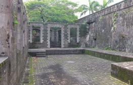
Kizhi
A grand open-air museum
What is this: An island with shores overgrown with reeds and an 18th-century churchyard, where monuments have been taken for the last fifty years wooden architecture. Not the most beautiful piece of sushi in the world Lake Onega, which has quietly become almost the most famous landmark of the Russian North.
Where to look: Twenty-two domes, covered with graying, silver-tinged shingles, are visible from the ship. The domes crown the stunning Church of the Transfiguration (1714), which has been closed for restoration for thirty years, but you can get into the nearby Church of the Intercession of the Blessed Virgin Mary and the bell tower of the Kizhi Pogost. Somewhat out of the way stands the Church of the Resurrection of Lazarus from the Murom Monastery, the oldest wooden church in the country. The cafe and post office are located near the pier, next to a souvenir shop selling puzzles with images of Kizhi and carved rowan figurines. After looking around the exhibition, it’s worth walking along the wooden boardwalks into the interior of the island, where two villages are hidden behind clover fields. Here you can take a break from the guides and buy the same scarves and figurines as in the store, only much cheaper and directly from the people who produce them.
Dangers: Mosquitoes, vipers, of which there are many on the island, and bustling international crowds can ruin your trip. To avoid the latter, it is better to find out in advance from the locals the schedule of tourist ships - hydrofoils should be called comets, and large cruise ships should be called f... dovos.
How to get there: Komets depart from the River Station in Petrozavodsk three times a day, but it is much more pleasant to hire a private boat from the pier.
Olkhon
Sacred island on Baikal
What is this: Baikal is generally quite a powerful place, but Olkhon Island is something outstanding even by local standards. The shamans and Buddhist lamas who lived here considered the island (as well as everything that grows and lives on the island) sacred, and as a result, the unprecedented beauties of Olkhon were preserved in their original form, they somehow managed not to be defaced even under Soviet rule. Plus, the Small Sea (the so-called strait separating Olkhon from the mainland) warms up more in summer than Baikal itself, and you don’t need to be a walrus to swim here in July-August. Shamans, by the way, still live here. And llamas too.
Where to look: The main postcard attraction is Cape Burkhan (aka Shamansky), the oldest shamanic point: two white marble rocks covered with red lichen. In the cave connecting the rocks, they first made sacrifices to the owner of the island, Ugute-noyon, then they built a Buddhist sanctuary, and for some time the icon of St. Nicholas the Wonderworker was kept here. All this is not without reason: if there is a moment of truth, there must be geographical point truth, Cape Burkhan - something like that. In general, you need to look in all directions at once: literally everything on Olkhon - from sunsets and sandy bays to rare flowers under your feet - seems alive and real, like nowhere else.
Dangers: The Buryats inhabiting the island are not entirely hospitable (especially when they drink). Contrary to the assurances of travel agents, mosquitoes do occur. But there are no ticks.
How to get there: Regular bus Irkutsk-Khuzhir
Andrei Bukharin, music critic:
“The most incredible place I have ever seen in my life is Lake Baikal. We spent a week on a small boat, saw bears sailing near the shore, and met the guards of the reserves, for whom a bag of sweets, a loaf of bread and a bottle of vodka are a royal gift. The water, clear for many meters, is amazing. And an incredible separation from civilization - you can sail for 24 hours and not only not meet someone, but simply not find any evidence of a person.”
Putorana Plateau
Mountain plateau with lunar landscapes
What is this: These mesas, cut by deep canyons, attract those who have had their fill of rafting, kayaking, canyoning and mountaineering and are now looking to combine all their hobbies into one sport.
Where to look: The highest mountains of the plateau are Kotuyskaya (1528 m) and Kamen (1664 m), which are very noticeable heights for the Central Siberian Plateau. In the inaccessible eastern part of the plateau, where it abruptly breaks down to the plain, on the Kanda River, there is one of the highest waterfalls in Russia - 108 meters high. It’s not easy to navigate the terrain, except perhaps using GPS to find out the names of rivers and mountains, so you just need to look around: waterfalls falling down from canyon walls, moss-covered stones, ice floes floating along the rivers even in August - and just completely lunar deserted landscapes, which the sun paints in different colors. And of course, the fish here is excellently caught and eaten in the fresh air with great appetite.
Dangers: It is better to go to the plateau with good physical fitness, basic mountain and water tourism skills, and best of all, as part of a group of specialists.
How to get there: From Norilsk, using a helicopter, you can organize a transfer to the plateau, and also agree on the place and time of the meeting with the helicopter pilots - in a week or two. Or from Norilsk you need to get to the port in the city of Talnakh, and there you need to negotiate with the owners of the boats - they usually take you across Lake Ayan.
Suzdal
City-scale museum exhibition
What is this: Former capital Russian state with a population of only 15 thousand people. A town that has preserved its appearance from the end of the 19th century: construction above three floors is prohibited here, and the only attribute of the Soviet era is the local administration building.
Where to look: The whole city is perceived as a museum exhibition. Cars on the streets are clearly unnecessary. In general, it is strange that cabs, carts, wagons and carriages have not appeared here yet. Apart from the obligatory excursion program - like the Kremlin, the Intercession Monastery (famous for the fact that the Moscow Grand Dukes sent unwanted wives here) and the Museum of Wooden Architecture - there is not much entertainment here. Here tasting room, where girls in kokoshniks pour local mead - with mint, horseradish and radishes. Here is a pottery workshop built with Dymov’s money. But all this is not so important. In Suzdal, the main pleasure you get is from the city itself, from walks, from strange, amazing discoveries. Like a secondary school on the territory of a convent. Or delicious pies for 10 rubles apiece, which for some reason are sold in the courtyard of an ordinary village hut.
Dangers: The main thing is not to live in a hotel. To achieve the maximum effect of immersion in Russian provincial reality, you need to settle in a village house. Fortunately, there are plenty of them (with central heating, hot water and generally all the amenities) here.
How to get there: From Vladimir - 20 kilometers by bus or car.
Mamaev kurgan
The most psychedelic Russian monument
What is this: Sculpture “The Motherland Calls!” and the park and monuments surrounding it, the memorial complex on Mamayev Kurgan, which was a key position in the struggle for Stalingrad during the Great Patriotic War. The gigantic project, conceived almost immediately after the war, took a long time to implement - the complex of monuments to the defenders of Stalingrad was built only in 1967.
Where to look: The main thing here is not even the famous 200 steps leading to, as it is written on the official website, the “main monument”. Actually, it is not at all necessary to overcome them. It is enough, while walking or driving past, to raise your head and see how a female Jedi is soaring in the skies and how, on a cloudy day, her sword almost pierces the frowning sky. Usually, to notice magic in routine, you have to try hard - but in Volgograd it’s quite simple. A giant woman with a sword, rising above the gray city, is probably the most undisguised miracle in the world.
Dangers: During the cold season, Volgograd is quite gloomy (although the Motherland makes an even stronger impression during this period).
How to get there: By plane (Aeroflot, Volga-Aviaexpress) or by train.
Evgeny Bakaev, presenter of radio “Silver Rain”:
“This is something that needs to be seen. I was there already as an adult, I was there as a child too, but still a person must go there in a conscious state in order to understand how many forces and people were involved in it, with what idea it was built, omitting some moral aspects, understand how significant, monumental it is built. In general, tears well up in your eyes when you see him. From the point of view of architecture, the integrity of the entire complex, it is amazing, not just in gigantism, but in thought and rigidity.”
Tuva
The birthplace of throat singing
What is this: One of the main lost worlds on the territory of Russia, the most diverse landscapes, from sandy deserts(closer to Mongolia) to alpine meadows (in the foothills of the Sayan Mountains), the geographical center of Asia and - thanks to the numerous burial mounds of Scythian times - the archaeological Mecca.
Where to look: In Kyzyl, on the Yenisei embankment, there is a symbolic stele “Center of Asia”, behind it the blue Sayan Mountains merge with the sky, nearby there is a series of shamanic yurts belonging to various associations and schools. The main ones start from Kyzyl tourist routes: the closest one is in the village of Arzhaan, near which in 2000 a Hermitage expedition opened a Scythian tomb and discovered 20 kg of gold jewelry. There are also lakes in the Todzha Valley, the largest - Azas, slightly smaller than Baikal - along the banks covered with incredibly beautiful white water lilies; horseback riding trips to petroglyphs - rock paintings of the Neolithic era - and ancient stone idols, trips to the homeland of the Goloviki Khoomeyzhiler and to the Old Believer villages of Sizim and Erzhey, where schoolchildren are required to study Old Slavic. Any undertaking here is not complete without shamanic rituals at sunset and Tuvan tea shai, brewed over a fire with kumis and salt. Every year at the end of July, a live music festival of the same name is held on the ruins of the Ustuu-Khuree monastery with the aim of restoring the Buddhist shrine. Tuva's latest megaproject is the restoration of Por-Bazhyn, an 8th-century Uyghur fortress with a Buddhist temple in the middle, located on an island in Lake Tere-Khol in southeastern Tuva.
Dangers: Get lost. The population density in Tuva is less than two people per square kilometer, mobile phones only work in the capital, so it is best to travel as part of an organized group with a guide.
How to get there: There is no railway in Tuva, so, apart from cars, the main means of transportation are horses and tiny An-2 planes. The same An-2s fly to Kyzyl from Krasnoyarsk and Novosibirsk.
Optina Pustyn
The main monastery of the country
What is this: The monastery near the city of Kozelsk is not distinguished by either its particular antiquity or the strictness of its charter; nevertheless, it is Optina that is considered the hidden heart of the country. The reason for this is the elders: monks who, through spiritual exploits, have acquired the gift of prophecy, capable of seeing through a person. Dostoevsky wrote his Zosima from the Optina elder Ambrose; Tolstoy fled here before his death; Gogol was going to become a monk here.
Where to look: The main thing that is in Optina are things that you cannot see with your eyes, here you very keenly feel what the words “a place of prayer” mean, but you feel it rather with your skin. The most beautiful thing within the walls of the monastery is the Vvedensky Cathedral of the mid-18th century, the most beautiful thing outside the walls is a grove with centuries-old ship pines and Lake Love, which in the late 80s became an all-Union gathering place for hippies: Father Sergius, one of the first inhabitants of the revived monastery (formerly Moscow system specialist Gosha Terrorist), baptized them right in the lake.
Dangers: Like any place of power, Optina acts powerfully and unpredictably. For some, their mobile phones cannot be picked up or their GPS fails; for others, they lose sleep and experience severe, inexplicable withdrawal symptoms.
How to get there: Bus Kaluga-Kozelsk, then go east along the highway to Sosensky, after the bridge over the Zhizdra River, take the first left.
Lake Pleshcheyevo
A reservoir with historical surroundings on the line of the Golden Ring of Russia
What is this: A large oval lake of glacial origin, surrounded by man-made and natural monuments, - the shores began to be inhabited two thousand years ago. Nowadays, Pleshcheyka is chosen by the capital's kiters and windsurfers.
Where to look: Due to the number of attractions around the lake, you may not even get to it the first time: the Iron Museum, the Teapot Museum, the arboretum, museums of crafts and ancient operating locomotives with a piece railway in nearby Pereslavl (see page 47); monasteries (Nikitinsky, Nikolsky, Danilovsky, Fedorovsky and Goritsky - in the refectory of the latter there is a local history museum). As well as churches, a real holy spring and visible remains of ancient settlements and shrines. Right on the shore lies the object of pagan worship - the Blue Stone: several generations of priests tried to fight the belief in its miraculous power. According to legend, the buried and recessed stone itself climbed out of the holes and from the bottom of the lake - and now, of its own free will, it sinks underground. Among the estates, the most popular is “Peter’s Boat”: here in 1692, Peter I created the famous amusing flotilla - and the Russian fleet began with it.
The lake itself is the closest place to Moscow, suitable for surfing and kiting at almost any time of the year: firstly, a strong and uniform wind always blows here, secondly, the shore is shallow, and thirdly, due to the shallowness, the water in the lake is very It heats up - and seasonal swimmers, as a rule, do not come here. People skate here even in winter - on the ice, and when the ice begins to melt, they put on warm wetsuits. In addition to periodic competitions, you can watch every now and then slender kiters splashing into the coastal reeds or hovering above the water and their colored snakes laid out along the banks.
Dangers: Due to the peculiarities of the bottom, it happens that the wind accelerates a one and a half meter wave that can capsize fishermen’s boats (that’s why there are almost no fishermen here either). The wind can easily knock over an inexperienced kiter, and those riding sometimes knock over the swimmers. However, neither surfers, nor kiters, nor swimmers seem to be afraid of all this.
How to get there: One and a half to two hours by car, by bus to Pereslavl from the bus station at the Shchelkovskaya metro station or by train to Sergiev Posad, and from there also by bus.
Plyos
Russian Switzerland
What is this: Locality on the Volga, which, despite its 600-year history and proud name - a city, remained a small village with wooden huts. Formerly a customs outpost, built by Prince Vasily I to save him from the Tatar Khan. Nowadays it is a health resort, a place of tourism and pilgrimage, nicknamed Russian Switzerland.
Where to look: Mostly in Plyos there is 19th century architecture - churches with domes and several local history museums. In the “Russian House” museum-estate you can eat porridge from the stove with a wooden spoon, work on a grain grater, light a light, iron clothes with a ruble, chop wood with a medieval ax - in general, join the original Russian life. But excursions cannot be compared with natural entertainment. You need to take with you a volume about the life and work of Levitan in order to find and see these landscapes with your own eyes. For some reason, Levitan forgot to draw the main attractions - the tree of love (two pine trees with an fused branch) and the stone of love (in the form of a phallic symbol). Favorite local pastimes are fishing and boating. In general, you need to start your trip with a sightseeing tour along the river, for example, on the Teplotekhnik boat.
Dangers: In the summer, various religious and political organizations hold their rallies in Plyos.
How to get there: From Ivanovo or Kostroma-Novaya station by taxi or bus.
Yasnaya Polyana
Estate of Leo Tolstoy
What is this: Thanks to Lenin’s words about the mirror of the Russian revolution, Yasnaya Polyana remained almost the only noble estate in Russia, where everything is as under the old owners. Thanks to the fact that the Volkonskys and Tolstoys were the owners, now here is one of the best museums in Russia. And all this is amidst stunning natural beauty.
Where to look: A house-museum, where everything is as it was in grandfather’s time. Tolstoy's grave is a turf-lined mound on the edge of a ravine. A regular park (with ponds and geometrically regular alleys) near the main house, but the main thing is the fantastically beautiful meadows and forests behind the estate, towards the Voronka River.
Dangers: An attempt to have a picnic in fantastically beautiful forests and meadows (which just begs to be) will inevitably end in a meeting with an evil forester.
How to get there: From Tula - by buses No. 114, 115, 117, 216 from the stop "Mosina Street". From Moscow - by excursion train "Yasnaya Polyana" from Kursky Station.
Balaam
Rocky northern island where monks grow watermelons
What is this: An island on Lake Ladoga, where one of the most important monasteries of the Russian Orthodox Church is located.
Where to look: Rocks, pine trees, rivers, Lake Ladoga, horses, churches, monks. Only here can you see such an idealistic landscape. The main thing is not to sit too long on the shore, but to go deep into the island as quickly as possible. There is less noise and tourists and more silence and monks. As a last resort, you can ride around the island in a peasant cart or in a carriage with a driver.
Dangers: see "How to get there"
How to get there: Despite the fact that in summer months Several ships go there every day; getting to the island is not easy. If you find yourself in Ladoga without tourist group, you will have to look for a long time for free space on the ship. All ships are pre-booked travel companies, pilgrims and Finns who love these places for cheap vodka, gasoline and prostitutes. At the same time, almost everything regular flights from Sortavala to Valaam were canceled, since after the collapse of the USSR, Rechflot motor ships were stolen.
Vasily Utkin, football commentator:
“I was on Valaam quite a long time ago, when I was still a fifteen-year-old teenager. On an excursion. At that time there was no functioning monastery there, but there was evidence of those times when, after the Second World War, disabled people, cripples, people without arms, without legs, stumps of essentially a human body lived there, who they decided to collect there so that they would not spoil the picture of a happy socialist life countries. I also remember the guide’s story about how the great writer Alexander Dumas, when he came to Valaam and saw Russian churches and temples on Valaam, said that the architect Gornostaev was the best in Russia. I remember how the domes of churches loomed out of the fog. I want to visit there now that the monastery has been restored.”
Mountain Altai
Four in one: forests, mountains, meadows and steppes
What is this: An amazing wildlife reserve, where, as in a geography textbook, deciduous forests give way to coniferous ones, and then give way to alpine meadows and high-mountain steppes. The birthplace of amazing light honey. One of the main places for water tourists.
Where to look: Main peak Gorny Altai, which means the center of this small universe is Belukha, surrounded by clouds and legends. To explore, you will have to climb 1500 m on foot to the base camp on the shore of Lake Akkem. Magnificent views of another Altai treasure - the Chulyshman valley - open from the Katu-Yaryk pass.
Dangers: Reports of robbery attacks on tourists are a thing of the past - local residents realized that they could earn much more by opening a recreation center, cafe or souvenir shop. Now the main risk is to find, on the site of a wonderful clearing, where last year there was only your tent, a freshly built shed and a parking lot.
How to get there: The nearest airport is in Barnaul. Regular buses run from Barnaul and from Biysk, where the nearest railway station is located, to Gorno-Altaisk.
Solovki
The monastery that became a symbol of the Gulag for a long time
What is this: The Solovetsky Archipelago, or Solovki, is located in the western part of the White Sea, near Arctic Circle, and consists of six large and many small islands. Main Island— Bolshoi Solovetsky is approximately 25 kilometers long and 16 kilometers wide.
Where to look: The main attraction of Solovki is the monastery itself. You can also climb Golgotha - the highest mountain of the Solovetsky archipelago, climb to the top of the stone church of Anzer Island, which offers an incredible view of the entire archipelago, and swim in the Holy Lake. Tourist season on Solovki lasts from June to October. The weather in summer is clear and sunny - from 18 to 30 degrees.
Dangers: Most excursions around the islands are on foot, and there is practically no transport.
How to get there: You can get to Solovki by plane from Arkhangelsk. He flies twice a week. There is also a waterway - from the port of the village of Rabocheostrovsk near the city of Kem, boats and barges sail to Solovki every morning.
Natalya Kulagina, writer:
“I remember the road to the North from the music in the player. "Civil Defense" and Diamanda Galas. The main law of the North is to obey strangers. They may turn out to be wanderers or signalmen sent especially for you. When I arrived at the pier, all the boats had already sailed away. It was nice to sleep on the seashore. A disgusting smell woke me up. Something was smelling right under my nose. A seal carcass bleached by the sun. Further events developed according to the plans of the mad screenwriter. I collected signs, weeded out strangers, drank vodka, joked with grown men. The North played strange games with me. At the end of the journey, I became free, fell in love, wrote books.”
Seliger
Lake District on the Valdai Hills
What is this: A large system of lakes between Moscow and St. Petersburg, surrounded by forests, on the Valdai Hills, with plenty of places to pitch a tent and a bunch of holiday homes.
Where to look: Motor ships with excursions ply along the lake - during the day you can look at the shores in search of the most successful and unoccupied beach, and in the evening there are discos and a restaurant on board. The most interesting thing on Seliger is the islands, there are 169 of them in total. On Stolbny Island there is the Nilova Hermitage, an active monastery, founded in the 16th century, it housed a camp for Polish prisoners of war in the 40s, and now restoration is in full swing. You can climb the bell tower - very touristy, but a wonderful view. Most large island— Khachin, there are several mesmerizing inland forest lakes with marvelous names like Beloe-Severnoe, Chernoe, Shchuchye, Plotvichye, Ostryuchye; There are similar inland lakes on the islands of Gorodomlya and Klichen. There is also a small island of God's Delo with the ruins of a no longer existing monastery called Novosolovetskaya Hermitage. But most of all Seliger is famous for its smoked eel - along the road it is best to look for signs with the inscription “Smoked fish”.
Dangers: On the islands there are swamps with a huge amount of strawberries - and, alas, vipers. In addition, at the height of summer there are a lot of noisy companies, children's camps and - not only that - the Nashi camp.
How to get there: From Moscow by car along the Leningradskoye or Volokolamsk highway; from Tushino by bus in 7 hours; With Leningradsky station by train. From St. Petersburg from Moskovsky station by train St. Petersburg - Velikie Luki.
Elena Yatsura, producer:
“I like not just Lake Seliger itself, but the entire route to it. Because on the road there is the ancient city of Torzhok with buildings of the 17th-18th centuries, the golden times of Russian architecture, temples. And the landmark, one might say, is the capital of Seliger - the city of Ostashkov. I was there in the spring - wonderful smells of lilac, geranium and violet in the ancient shutters. In general, he gives the impression of rigor and freshness. An additional option is the Nilov Hermitage Monastery. This is in the Ostashkov area. One of the richest monasteries in pre-revolutionary times. Excellent view both from the bell tower and onto it.”
Novgorod
The ancient capital of Russian democracy
What is this: Patriarchal regional center with an off-scale number of antiquities and attractions per square meter beyond all norms.
Where to look: Saint Sophia Cathedral- most ancient temple in the Russian North; its western gate, completely covered with tiny bronze figures, was taken by Karelians from the first Swedish capital of Sigtuna in 1187. Monument to the 1000th anniversary of Russia - bronze guide to Russian history. Historical Museum with a set of birch bark documents. Yuriev Monastery with St. George's Cathedral of the 12th century. The Vitoslavlitsy Museum of Wooden Architecture is a huge park with buildings without a single nail, brought from all over the area. The beach is right under the walls of the Kremlin, with a giant man-horse hanging over it, installed for the 40th anniversary of the Victory.
Dangers: Products of the local Alkon plant, not sold outside Novgorod, are “Marfa Posadnitsa” tincture, “Novgorodskoe Veche” vodka, “Old Russian” balm.
How to get there: By train from Moscow, St. Petersburg, Kaliningrad, Murmansk, Pskov.
Based on the votes and ratings of readers of the prestigious magazine Condé Nast Traveler, a rating of the most attractive countries for tourism was compiled. Almost 130 thousand people took part in the survey, which is simply incredibly large. And the opinions of so many travelers can actually be trusted. So it's time to find out which countries you should travel to first.
Morocco
Morocco is a treasure trove full of spice markets, surreal landscapes, incredible mosques and world-class surfing spots. The local cuisine is unlike any other in the world, as it combines elements of Arab, African, Persian and French schools.
Canada

The country offers travelers a variety of experiences, from connecting with wildlife on Vancouver Island to staying overnight at the oldest Ritz-Carlton hotel in North America in Montreal. And sledding in Quebec is something everyone should try in the winter.
Japan

Tokyo, Kyoto and Osaka are just the most interesting of the many places you should visit in Japan. This year, Kyoto, home to more than two thousand ancient temples, was voted the best city in the world.
Ireland

You can enjoy many different aspects of Ireland - from hotels set in former castles to bustling, world-famous Irish pubs. It is also recommended to rent a car and take the world's longest road trip along the Wild Atlantic Route.
Portugal

A small but respectable country neighboring Spain, it has its own distinct culture, cuisine and language. In summer, head towards the western village of Comporta to visit world-famous Ibiza. And, of course, no trip to Portugal would be complete without a glass of wine from the Douro subregion.
Mexico

Mexican cuisine has recently entered the ring with such giants as Spain and Italy. Over the past year, three restaurants located in Mexico City have been ranked among the top fifty in the world.
Netherlands

Travel to Amsterdam, Rotterdam and other impressive cities to visit incredible museums, taste incomparable coffee, and admire awe-inspiring scenery.
Sri Lanka

If you feel lost, this is the place that will help you find yourself again. Buy a ticket and board an old but sweet train that will take you into the unknown. Admire the scenery and buy pancakes and curry from the train vendors, but don't forget to get off for a closer look at the main attractions.
Vietnam

Celebrity chef Anthony Bourdain said his trip to Vietnam changed his life. He said that Vietnam was like a completely different planet that sucked him in and never let go. You can sip Vietnamese coffee and enjoy pho noodles all day long, or you can go down into the world's deepest cave.
South Africa

Cape Town ranked sixth on the list best cities this year. People are most drawn to Table Mountain and the local hotel resorts, but the rich vineyards and safaris are also worth a look.
India

The second most populous country in the world has a huge variety of places to visit - from sandy beaches Goa to the ancient Buddhist caves of Ajanta. Northern Kashmir is often called the Switzerland of India - time slows down there and the winter resorts are simply magnificent.
Türkiye

Travel to Turkey to see magnificent mosques, magical castles, and natural wonders such as Pamukkale (cotton castle), made up of a series of travertines filled with mineral-rich water.
Thailand

Thailand will tempt you with incredible culture, exotic cuisine and utopian resorts, whether you decide to simply enjoy unfamiliar and outlandish cuisine, travel from island to island, or choose another way to relax. Recently, there has been a rise in the number of holistic health resorts where you can relax and get rid of illnesses.
New Zealand

This the best place for adventure seekers. You can live in harsh conditions in a hut without electricity, immerse yourself in the healing waters of Maruya Springs, or hike through volcanic lands National Park Tongariro.
Australia

Melbourne has been named the city with the most high level life this year, so taking a trip there is also a good idea. There you can find the Mornington Peninsula, with vineyards, beaches and its own food scene.
Greece

Athens is a city that also made it onto the list of top places you should see in 2015. In the midst of the financial crisis, museums, hotels and shops are thriving, fueling the capital's cultural renaissance. And the turquoise waters and salty wind of Mykonos will always attract travelers.
USA

Travelers to the United States are drawn to glittering cities, family-friendly theme parks and natural beauty.
Spain

Spain has been the epicenter of the world's cutting-edge cuisine for quite some time. It would be a good idea to plan your trip here, including visits to the most vibrant and famous restaurants. The best time to visit Spain is in April.
France

The country that gave its people cabarets, champagne and hundreds of varieties of cheese is also one of the most... romantic places on the ground. In the spring, traveling around this country will be simply exciting.
Italy

Who can resist the call of pasta and beautiful people? For five years in a row Italy has been called the best country for tourism. And here you can have a great rest - drink wine, make friends with sociable local residents or soak in the sun on the beach.
Attractions
194300
If you find yourself in Moscow for the first time, passing through, and, ironically, you only have one day to see the city, do not try to embrace the immensity and focus your attention on the “calling cards” of the capital.
We offer you an interesting and non-tiring route for exploring the city on your own. The center of Moscow, like any capital since ancient and rich history, is replete with must-see iconic places, so you won't have to use much of the first half of the day public transport, but after lunch you still have to get acquainted with the intricacies of the famous Moscow metro and try out the transfer system.
If you are in Moscow for the first time, passing through, and, ironically, to see the city you have only one day, do not try to see it all and focus your attention on "city business cards" of Moscow. We offer you an interesting and easy route for self-seeing the city. The center of Moscow, like any other capital with ancient and rich history, is full of worth seeing places. For this reason, there is no need to use public transportation for the first half of your day, but after lunch, you will be able to get acquainted with the intricacies of famous Moscow subway with its transfer stations, and if necessary, use free wi -fi connection on Circle Line.
Sight
The starting point of our journey will be the “Revolution Square” station - a kind of advance ahead of the pleasure of seeing the city’s attractions. Perhaps not a single sightseeing tour is complete without going down here, because there are few subways in the world that you can walk through as if you were walking through an art museum. Along the entire length of the station's lobby, opened in 1938 under Joseph Stalin, 76 sculptures are installed in the arches, glorifying twenty images of representatives of the Soviet people. Moreover, the monuments immortalized not only revolutionaries, soldiers and heroes of labor - there are collective farmers, athletes, students, pioneers and even mothers and fathers holding children in their arms. It is worth paying attention to the figures of a parachutist, a girl with a rifle and a disco thrower, considered unspoken symbols of Soviet feminism. This station has its own interesting legends: superstitious students touch the nose of a border guard dog before taking exams, and touching a student’s shoe supposedly helps to quickly recover from unhappy, unrequited love.
The eastern lobby leads tourists to Bogoyavlensky Lane and Nikolskaya Street, from where we get to main symbol Russia in general, and Moscow in particular - Red Square.
Metro Station Ploschad Revolyutsii
The starting point of our trip is metro station Ploschad Revolyutsii - a kind of advance, anticipating the pleasure of seeing the city sights. Perhaps, no City Tour in the world is without visiting the station that is as significant as an art museum. Throughout the lobby length, opened in 1938 under Joseph Stalin, there are 76 sculptures put in arches, glorifying twenty images of Soviet people representatives. Monuments have immortalized not only revolutionaries, soldiers and heroes of labor - there are collective farmers, athletes, students, pioneers, and even mother and father holding children. It is worth paying attention to the figures of a paratrooper, girls with rifle and discus-thraw athletes, considered to be silent symbols of Soviet feminism. There are interesting legends: superstitious students before touching the nose of the border guard dog before final exams, and touching the student's shoe, allegedly, helps to get better from unhappy, unrequited love.
The eastern lobby leads tourists to Bogoyavlensky Lane and to Nikolskaya Street, from where you get to the main symbol of Russia in general, and Moscow in particular - the Red Square.
Read completely CollapseMetro "Revolution Square"
Sight
A constant gathering place for tourists and the main arena of political, military, social and cultural events in the city and throughout Russia. In 1941, Soviet troops left here for the front, and in 1945 the first Victory Parade took place. The modern ensemble of the square is a unique complex of buildings of different eras and styles. The legend about the Church of the Intercession of the Mother of God on the Moat, better known as St. Basil's Cathedral, says that Ivan the Terrible ordered the architects to be blinded so that they could never build a second such temple anywhere else. Near its walls rises the Execution Place - a fenced stone platform from which the royal decrees were read out and sentences were read out. At the opposite, northern end of the square stands the building of the Historical Museum, its decor reminiscent of an elegant Russian tower. In 1924, the center of the western part of Red Square became the mausoleum - the tomb of the body of the leader of the world proletariat V.I. Lenin, built on the model of the tomb of the Halicarnassian king Mausolus. Along the eastern border of the square stretches the building of the Main Department Store of the country. Back in the 15th century, this place was a center of trade; at the beginning of the 19th century, by order of the tsar, shopping arcades, the building we know now appeared already in 1893. The GUM galleries feature music from Soviet times, and chamber exhibitions and fashion shows are regularly held. We invite you to enjoy the legendary ice cream in a waffle cup here, stroll through the galleries to the songs of Eduard Khil and Maya Kristalinskaya, and visit Gastronome No. 1, where nostalgic sprat, stewed meat and juices in three-liter jars occupy not the least place among the delicacies. Here you can have a hearty breakfast in one of the coffee shops, or take coffee with you, and in the same “Gastronom” buy some dessert or pastry, for example, a pack of the famous Savoyardi cookies and, if the weather permits, have a snack on the street , admiring the architectural beauty of the square ensemble. In winter, a Christmas market and the main city skating rink open in front of the GUM building.
You can get to the Kremlin territory from Red Square on foot through the Alexander Garden.
A constant place of tourist crowds and the main arena of political, military, social and cultural events in the city, and across Russia. Here, in 1941, the Soviet troops were headed to the front line, and in 1945 the first Victory Parade was held. The modern ensemble of the square is a unique complex of buildings of different past times and styles. The legend of Saint Basil's Cathedral says that Ivan the Fearsome ordered to blind architects, so that they could never build the same church anywhere else. Near its walls stands the Lobnoye Mesto - a fenced stone platform from which royal decrees and verdicts were announced On the opposite, northern side of the square stands the building of State Historical Museum, its decor resembling elegant Russian tower-rooms. In western part of the Red Square in 1924 mausoleum appeared - the tomb of embalmed body of the leader of the world proletariat - Lenin. On the eastern border of the square, there is a building of the Main Universal Store. In the XV century, this place was the center of trade, at the beginning of the XIX century, according to the tsar's order, trade rows were built here, and modern building appeared in 1893. Music of Soviet time, chamber exhibitions and fashion shows. Visiting GUM try legendary ice cream in a waffle cone, visit "Grocery Store #1" with worldwide delicacies and products well known to people born in Soviet Union. Here you can have a hearty breakfast in one of GUM cafes, or take coffee to go, at “Grocery Store #1 " buy a dessert or pastry, for example, Savoiardi Biscuits. If the weather allows, have a snack outside, admiring the architectural beauties. In winter, in front of GUM building, there is a Christmas fair and ice skating rink.
From Red Square walk to Alexander Garden and enter Kremlin territory.
Read completely Collapse Sight
The park near the Kremlin walls, which has been transformed in recent years, has become one of the most favorite vacation spots for city residents. There is a complex of fountains decorated with sculptural compositions in the form of heroes of Russian fairy tales; in the spring, lilacs and chestnuts bloom in lush colors, and in the best traditions European capitals Here you are allowed to relax on the lawns.
There are two ways to enter the Kremlin - the more convenient and interesting entrance is through the Kutafya Tower, next to which there are ticket offices where tourists can buy admission ticket, as well as tickets to selected museums and cathedrals of the Kremlin.
Today, the Moscow Kremlin is considered the largest active fortress in Europe. You can visit it either in the format of an individual visit or with an excursion, of which there are about a hundred to suit every taste: classic sightseeing, art history, historical, religious, mystical, detective, children's... You can spend more than one hour on a detailed inspection of the Kremlin, but if time, as in our case, is short, then we can limit ourselves a short walk with duty personnel against the backdrop of the Tsar Bell and the Tsar Cannon and be sure to visit the very high place Kremlin - on Cathedral Square with its four churches and the bell tower of Ivan the Great, which existed until the beginning of the 18th century tallest building cities. Since then, hundreds of high-rise buildings and skyscrapers have been built in the capital, but such powerful energy, perhaps, cannot be found anywhere.
From the Kremlin via Okhotny Ryad You can walk to Theater Square in ten minutes.
Alexander Garden and Kremlin
The park beneath the Kremlin walls has changed in recent years and become one of the favorite places for the rest. There is a fountain complex decorated with sculptures of characters of Russian fairy tales, lilacs and chestnuts are blossomed in spring, and is allowed to lay down on laws.
You can enter Kremlin in two ways: more convenient and interesting way is to enter through Kutafiya Tower. Next to entrance, there are cash desks, where tourists can buy admission tickets, tickets to Kremlin museums and cathedrals.
Today Moscow Kremlin is considered to be the largest existing fortress in Europe. You can visit it by yourself or with a tour for any taste: city, art, historical, religious, mystic, detective or children tour. Visit to Kremlin can last more than an hour, but if time is limited, you can have a small walk through fortress and pics points in front of Tsar-Bell and Tsar-Cannon, and visit the highest Kremlin point - Cathedral Square with its four temples and Ivan the Great Bell Tower. Since then, hundreds of skyscrapers have been built in Moscow, but such a powerful energy you can fill only on Cathedral Square.
From Kremlin through Okhotny Ryad Street you can walk to Teatralnaya Square in ten minutes.
Read completely Collapse Sight
Here in 2011, the completely restored building of the legendary Bolshoi Theater opened to the public. Over its two-century history, it suffered from fires four times and was even blown up by a bomb dropped on it during the Second World War. Now the Bolshoi is welcoming visitors again. Buying tickets here is not an easy task, but to see with your own eyes the historical reconstruction of the building, familiar to everyone from the 100-ruble banknote, is quite worth it, especially since it is one of the most famous characters city, which inscribed in the history of world art the names of Anna Pavlova, Galina Ulanova, Maya Plisetskaya and other great ballet masters. On both sides of the Bolshoi there are two more theaters - Maly and RAMT, on the right you can see the building of a luxury shopping center TSUM. There is a small park with a fountain in front of the theater, where you can take good memorable shots. During the Victory Day celebrations, meetings of war veterans are held here.
Teatralnaya Square
Here in 2011 a renovated building of the legendary Bolshoi Theater opened its doors. For its two centuries of existence, the theater suffered from four fires and even was blown up by a bomb dropped on the building during the Second World War. To buy tickets for opera or ballet here is very difficult, but to see with your own eyes the historical reconstruction of the building (Bolshoi Theater image is on 100 ruble note) is worth it. On either side of Bolshoi Theater there are two more theaters - Small and RAMT, on the right side you can see is TSUM building for luxury shopping. In front of the theater, there is a small square with fountain, where you can take memorable pics. During the Victory Day celebration there are gatherings of war veterans.
Read completely CollapseTheater Square, Moscow
Restaurant
The place for our lunch was the Bok restaurant on Petrovka. The central place in the concept of the project is occupied by dishes that are prepared from the same side - veal, pork or lamb. The menu includes ribs - braised, grilled and baked, a huge bone-in steak (tomahawk), flank steak, salad and soup "BOK" made from flank pulp, as well as dishes that can be ordered for a group. The chef cuts up a side of lamb, a side of beef, a side of goat or a side of veal in front of the guests, cooks it in the open kitchen and serves it accompanied by detailed stories about the cooking method and the specifics of meat.
The menu not only has a large selection of ribs prepared in different ways, but also dishes from other parts - oxtails, tongues, osso buco, liver, brains and marrow bones, pates and about 15 types of dry-aged steaks.
Read completely Collapse Restaurant
If you want the delights of Azerbaijani cuisine, then choose the Barashka restaurant for lunch, which is also located on Petrovka. Modern European interior, serving, presentation and traditional Azerbaijani cuisine - an unusual but absolutely logical combination. The transparent entrance doors are as pitiless as the weather forecast, but inside it is always warm. The large bar counter is fully decorated with trays of sweets and seasonal fruits. Soft light, wooden walls, sofas with cushions made of woolen rugs - kilims. Quinces and pomegranates are of unearthly beauty - both in vases and in niches and in general wherever you can put a tray or bowl of fruit. There is a whole wall of jars with preserved lemons, and on the windowsill there are tubs of peppers.
Read completely Collapse Museum, Attraction, Galleries & Exhibitions
The main building of the State Tretyakov Gallery, decorated in Russian style according to the design of the famous artist Viktor Vasnetsov, is located in a quiet Lavrushinsky Lane. One of the world's largest collections of Russian painting of the late 11th - early 20th centuries is stored here, and you can see paintings by great masters, as well as sculptures, graphics, items made of precious metals and stones. Sightseeing tour The exhibition lasts three hours, but if you wish, you can look here for a more cursory acquaintance with the main masterpieces of Russian painting. In one hour, you can try to unravel the mystery of Kramskoy’s “The Stranger,” admire Borovikovsky’s Princess Lopukhina and Tropinin’s lacemaker, look into the bottomless eyes of Vrubel’s “The Swan Princess,” marvel at the scale of Ivanov’s painting “The Appearance of Christ to the People,” and admire the depiction of details in “The Doors of Tamerlane.” "Vereshchagin and freeze in sacred horror before his own "Apotheosis of War", and also easily recognize the arriving rooks of Savrasov, discover that in the painting "The Bathing of the Red Horse" Petrov-Vodkin allegedly depicted the young Vladimir Nabokov, and see what she looked like Red Square, which we visited the day before, at the end of the 17th century, on the “Morning of the Streltsy Execution” by Surikov.
From the Tretyakovskaya station, in fifteen minutes you can get to Kropotkinskaya with two transfers, where our next point is located - the Cathedral of Christ the Savior.
Tretyakov Gallery
The main building of the State Tretyakov Gallery, designed in Russian style according to the project of the famous artist Viktor Vasnetsov, is located in a quiet Lavrushinsky lane. It keeps one of the largest collections of Russian paintings of the late XI - early XX centuries in the world, and you can see the canvases of great masters, as well as sculptures, graphics, precious metal and stone jewelry. The exhibition tour lasts three hours, but if you want, you can come by for a cursory examination with main masterpieces of Russian paintings. In one hour you can try to solve the mystery of “An Unknown Woman” portrait by Kramskoy, admire the princess Lopukhina by Borovikovsky and Tropinin’s lacemakers; look into the abyss of eyes of Vrubel “The Swan Princess”, be impressed by the size of Ivanov"s painting “The Appearance of Christ Before the People”, admire the drawing details of “Tamerlan"s Doors” by Vereshchagin and freeze in a sacred horror in front of his "Apotheosis of the war"; easily recognize “The Rooks Have Come Back” by Savrasov, to find that in the painting “Bathing of a Red Horse” by Petrov-Vodkin, allegedly, painted a young Vladimir Nabokov, and see what Red Square looked like in the 17th century on Surikov's “The Morning of the Streltsy Execution”.
With transfers from “Tretyakovskaya” metro station in fifteen minutes, you can be on Kropotkinskaya station, where our next point is located - the Cathedral of Christ the Saviour.
Read completely Collapse Sight
If you prefer walking to wandering through the endless halls of museums, we offer a wonderful scenic route through the center. Before this, you can join a habit popular among Muscovites and grab a coffee to go from one of the nearby coffee shops, for example, Coffeeshop Company or Coffee House. Walking along Lavrushinsky Lane, you will come to the Luzhkov Bridge across the Vodootvodny Canal, where, according to tradition, newlyweds hang locks on the “love trees” specially installed here on their wedding day. Next, proceed to Sofiyskaya Embankment through Bolotnaya Square, which in the Middle Ages was the site of public festivities and public executions, and is now perhaps most famous for the anti-government demonstrations of 2012. Opposite you can see the legendary “House on the Embankment” - a masterpiece of the Stalinist constructivist era, built to house the Soviet scientific, political and cultural elite after the capital was transferred from St. Petersburg to Moscow. Climbing the Bolshoi A stone bridge, follow it across the Moscow River, admiring the panorama of the Kremlin and the Cathedral of Christ the Savior. In total, the entire walk will take about an hour.
Alternative - walk from Tretyakov Gallery to Cathedral of Christ the Saviour
If rather walking through museum halls, you prefer walking through the streets we offer a beautiful scenic route through the center of Moscow. Before that, you can join the popular habit among Moscow citizens and take coffee to go in one of nearby coffee shops, for example, Coffeeshop Company or Coffee House.
Passing along Lavrushinsky lane, you will get to Luzhkov Bridge through the Vodootvodny Canal, where according to tradition the newlyweds hang a lock on the day of the wedding on special “love trees”. Then proceed to Sophia embankment through Bolotnaya Square, which in the Middle Ages was a place of public festivals and executions, and now mostly famous for anti-government demonstrations in 2012. Opposite the square you can see full of legends “House on the Embankment” - a masterpiece of the Stalin constructivism, built to accommodate the Soviet scientific, political and cultural elite after capital transfer from St. Petersburg to Moscow. Go up to the Great Stone Bridge, walk through it enjoying Moscow River, Kremlin and the Cathedral of Christ the Savior views. The whole walk will take about an hour.
Read completely Collapse Landmark, Religion, Landmark
Its official name is the Cathedral of the Nativity of Christ. This is the most big temple in Russia, capable of accommodating up to 10,000 people. The current building was built in 2000 in six years to replace the previous temple, which was erected over forty-four years in honor of the victory over Napoleon’s army, and destroyed overnight on the orders of Stalin. The temple hosts services, sacred music concerts and religious exhibitions. Orthodox Christians come here to venerate the relics of saints: Apostle Andrew the First-Called, John the Baptist, John Chrysostom and others. In addition, many shrines are kept here, including a nail from the cross of the Lord and the robe of the Virgin Mary. On the roof between the bell towers there are observation platforms from which you can admire the center of Moscow from a bird's eye view. From here you can see the monument to Peter I by Zurab Tsereteli, which Muscovites dislike so much, and form your own opinion about it. You can go up to the sites only as part of excursions and pay for the entrance ticket. At the foot of the temple there is a beautiful square with flower beds, fountains and a spectacular monument to Emperor Alexander II.
Next to the Cathedral of Christ the Savior is the Kropotkinskaya metro station of the Sokolnicheskaya line. From here you can get to Vorobyovy Gory station in a straight line in ten minutes.
The Cathedral of Christ the Saviour
This is the largest temple in Russia, with capacity of up to 10,000 people. The present building was built in 2000 in six years instead of the former temple, built in honor of the victory over the army of Napoleon, and destroyed overnight by the order of Stalin. The church divines services, arranges concerts of sacred music and religious exhibits. The Orthodox come here to bow to the relics of the saints: Apostle Andrew, John the Baptist, John Chrysostom and others. In addition, many sacred objects are kept here, among which there is a Holy Nail with which Christ was crucified and Virgin’s Robe. On the roof between the bell towers there are observation points from which you can admire the center of Moscow. You can see the monument to Peter I, the work of Zurab Tsereteli. To get to observation points climb is possible only as part of a tour. At the base of cathedral is a beautiful square with flowerbeds, fountains and a spectacular monument of Emperor Alexander II.
Near the Cathedral of Christ the Saviour is a metro station “Kropotkinskaya”. From here you can take a direct line to the station “Vorobyovy Gory”.
Read completely Collapse Park, Landmark, Panoramic view
Vorobyovy Gory is the world's first metro station located on a bridge over the river and the longest station in Moscow. A half-hour walk along the embankment will take you to observation deck, located on one of the seven city hills, from where, in clear weather, perhaps the best view to the panorama of Golden Dome. You will be able to see the Kremlin stars, the domes of the Cathedral of Christ the Savior, St. Basil's Cathedral and the Novodevichy Convent, the White House, “Stalinist” high-rise buildings, skyscrapers of the Moscow City complex, Ostankino and Shukhov TV towers, the building of the Presidium of the Russian Academy of Sciences and the Luzhniki sports complex. In the more than fifty years since the opening of the site, the appearance of Moscow has changed beyond recognition, and cranes sticking out everywhere indicate that changes continue. Therefore, you should not miss the chance to see today’s capital from here, which is transforming every day.
From the Vorobyovy Gory station, in half an hour you will reach Barrikadnaya, near which the Moscow Planetarium is located.
Vorobyovy Gory, observation deck
“Sparrow Hills”- the world"s first metro station, located on a bridge over the river and the longest station in Moscow. A half-hour walk along the embankment takes you to observation deck, arranged on one of the seven city hills, from where is the best view of Golden-domed Moscow. You can see Kremlin stars, domes of the Cathedral of Christ the Saviour, St. Basil's Cathedral and the Novodevichy monastery, the White House, “Stalin skyscrapers”, Moscow City commercial district, Ostankino and Shukhov TV towers, the building of the Presidium of the Russian Academy of Sciences and Luzhniki sports complex.
From the metro station “Vorobyovy Gory” in half an hour you will reach the “Barricadnaya” station, near which is Moscow Planetarium.
Read completely Collapse Planetarium, Museum, Attraction
In order for the city to remain forever in memory as “the very best,” we suggest ending the day with an equally bright and spectacular impression - visiting the country’s first planetarium, which, in addition, is also famous for the largest dome screen in Europe, which can accommodate 9,000 stars! Watch a film about our Universe, visit the Urania Museum with models of planets solar system and fragments of real meteorites, and in cloudless weather, do not deny yourself the pleasure of going up to the large observatory on the roof to watch real planets and stars through telescopes. Such an unforgettable sight is suitable for a romantic evening, for a trip with children, or simply for expanding your own horizons.
Moscow Planetarium
To ensure that the city remains forever in memory as the "most-most", we suggest ending the day with an equally stunning and spectacular impression - to visit the first planetarium of the country, which, besides this, is also famous for the largest dome screen in Europe with 9000 stars! Watch a movie about our universe, visit Urania museum with models of the planets of the solar system and fragments of real meteorites. When the weather is clear go up to the large observatory on the roof to observe the real planets and stars in telescopes. This unforgettable sight will be perfect for a romantic evening, time with children, and for widening your horizons.
Read completely CollapseView all objects on the map