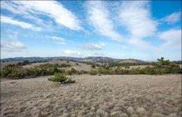
Krasnaya Polyana's hiking routes. One day in Krasnaya Polyana
Health Trail (Rose Farm) is three hiking route through the forest on the slopes of the Mountain Psekhako. Each of them is varying degrees of complexity. What is good to get here is not necessary - the trail begins directly from the resort itself. The easiest route is under the power of anyone - it can even go through the child. But the most difficult will overcome the most courageous - here about two hours of the path through the forest.
Immediately, we note that in the large Sochi lately, various health paths and terrencours are in fashion. Therefore, if you wanted to read, about Terrenkur, which is close to Sochi, then this can be done.
The entire lower slope of the Psekhako Mountain, according to which the ternshur rose is a rose, littered with trees. In essence, this is a magnificent southern forest, through which a path stylized under these almost wild places. In the warm season, the trees covers moss, turning the forest into a plush and completely green, as if fabulous. It should be borne in mind that with any route you will have to go up, and if you do not like it completely, then you can hardly long for your teeth.
The local health trail is one of best places For a summer walk.
Routes

Every 3 route here, each of which begins between the beach and the hotel. End also in one place - a little higher along the river from the entrance.
The most simply route is only 310 meters and you can go through it for 10-15 minutes. If you have a lot of time and take pictures wherever it is possible, then you can go this third kilometer about half an hour. More hardly happens. Interesting places Here is a minimum
The average ring is 1630 meters and if you go on it, the road will take about one and a half hours. There will be two spring with drinking water, observation deck, waterfall and one playground for yoga. And only here is small lakewhere you can swim. Water, the truth is very cold. In the diagram it is marked as a font.
Big ring - 1970 meters. The most difficult and long way. Will take at least two hours. Flying here will not be, but there will be a glade of power and another playground for yoga.
Want more? No one bothers to combine all the ways into one mega route and visit everything at all.
Where is and how to get
Mountain health trail is in the territory of the coolest mountain resort Rosa Khutor. It begins from the lake beach, which can, and count the point of reference.
But in order to go for a walk along the health path, initially need to somehow get to the most mountain resort. To get on a rose a farm with four ways:
- You can easily take your car. First you need to get to the Adler Airport, and then just directly go along the A148 highway. The road is long enough - 40 kilometers from the airport, and from the center of Sochi more than 70. But the canvas here is new and ride one pleasure. In general, this is the most convenient way and it is good to everyone, except that the driver will have to drive enough enough, but not drink alcohol. If you go on a trip one or two, then the gasoline is more expensive than the train and the more bus.
- You can drive on the highway swallow. If you go from Sochi, then this is definitely the fastest way and is quite comfortable. Electric trains are not crowded, if not in the city does not happen in an extraordinary, so it will be quite comfortable to go. Of the minuses - more expensive than the bus and you need to adapt to the schedule, which is not always nice
- Another way to get to the rose the farm is, of course, the bus. Here best priceHere there is no tight binding to the schedule and the start of the start. For example, you can come from Sochi (105, 105C), from hosts and curbstures and heaps of stops along the way (105) and from Adler from the shopping center " New century"(135). Naturally, you can sit at any stop of the A148 track. Separately, it should be noted that it is guaranteed to get seat place, you need to go from the initial stop (Sochi bus station or shopping center New century in Adler).
- Theoretically, the farm can be arrived within organized excursion. But there are no excursions from Sochi or Adler to the health path, so this option is not suitable for us anyway.
- If you arrived at the train, you will need to go up the flow through the entire resort winter town to the Mzmitt Square. The path will take about 15-20 minutes and there will be many shops on the way, where you can buy something. Identify the Mzmitt Square in McDonalds, which is located here. Next, go through the bridge and turn right. In a couple of minutes you will reach the next bridge. He needs to turn left, go along the track for another minute and the trail itself begins. You can focus on the Loystone Beach "Rosa Khutor" located next to the path.
- If you arrived by bus, it will stop just around Mzymta Square. What to do next is described above. Where to go to those who self arrived on the car depends on where it managed to park. In any case, focus on the square and McDonalds.
I visited your trail. Somehow weakly. Is there something more complicated?
Something is more complicated always.
There is a waterfall nearby, the road to which is completely unclear. Once this route was popular among tourists loving leisureBut now everyone goes on more comfortable routes.
You can also go to the waterfall that in the resort slides city. But not from the lifting at an altitude of 960 meters, but from the bottom. Then the path in one direction will be about 10 kilometers.
An even more complicated hike on. If you don't care, then you are enlightened and you can generally all.
Should I go? (and a little about the reviews)
Doubt whether it is your place of attention? To be honest, I do not know because you, unfortunately, do not know. Therefore, if you like beautiful natural places and active walks, if you love forests and mountains, it is worth it. Numerous reviews that can be found on the Internet are rarely monotonous - they say that the place is really cool. But if in your understanding best rest This is lying on the sofa or, as a last resort, on the beach, despite all the feedback, you can hardly like it here.
A few moments
- the entrance is free
- Take with me food and water. Here it is nowhere to buy
- This is a wonderful place. And it will be the same beautiful if you do not throw garbage here. Respect beauty, nature and their country
- The camera is a mandatory attribute in this campaign. In addition to the beautiful forest, very cool species open here at times.
- An interesting figure: everything on all routes of as many as 919 steps. This is really a lot. For girls, walking on it is a guarantee of a very beautiful priest. This is the health trail in general.
- Do not walk along the path in the rain and, especially in the snow. The road can be very slippery, and it is unsafe.
- If you like active rest and are here not in winter, then you must visit the path. This is an amazing place. A few meters from the most perfect mountain resort in Russia begin ... Beautiful and almost wild places.
Fast navigation on page:
# , # , # , # , # , #
For our parents, deubs and grandmothers Sochi have always been a popular destination of July-August beach holidays. For my peers Sochi and Krasnaya Polyana, this is the place where the winter Olympiad was held in 2014. For me, it is primarily a crazy beauty nature and mountains. So beautiful that a few years ago, my wife and I left Moscow and now live in Sochi. For five years from the moment of the move, I have already made more than 70 campaigns in the Caucasus and decided that I have a moral right to do something like a "guidebook" on this fantastic for any tourist and Outdorchik region! On this big page (stocking attention and patience), I collected all the basic information for planning and organizing an independent hike in the surroundings of Sochi and Red Polyana.
I will start with what attracted us personally in this place so much that we moved here to live?
Why Sochi and Krasnaya Polyana?
- Soft climate and super ecology. Despite the fact that in the winter months on the coast, there are often tightening rains, and in the mountains - snowfalls, the climate here is of course more comfortable for life than in the native Siberia for me, or in the Urals or even in the central Russian lane. About ecology and not to speak. Sochi do not have large industrial enterprises, and daily morning sea and evening mountain breeze cleaned the air of the city from exhaust gases.
- Long campaign season. The climate of these places allows you to go to the mountains for six months - from June to November !! And if you pay attention not only to the mountains, but also on the coast with its numerous waterfalls and gorges, then the season for hiking becomes year-round!
- Huge opportunities for multi-sports. Those who love sports and mountains can find entertainment for every taste: classic hiking and mountain hiking, Mountain-bike, routes Via Feratta, Rafting, Canyoning and even "Banges", jumping with a rope!
- Excellent infrastructure. New railway From the airport I. railway Station In Adler or Sochi, during an hour, I will dominate you to the Red Polyana, and excellent trails and even the presence of mountain shelters and tent camps allow you to walk in the mountains with comfort and even small children and at the same time enjoy the beauty of nature. The aircraft from Moscow is also inexpensive compared to flights abroad (just buy in advance!).
- Safety. You forgue me tolers and cosmopolitans, Sochi and surroundings are fundamentally different from other regions of the Caucasus. You can be sure that you will not have any skirmishes with local. The village of Krasnaya Polyana is historically in general in the ethnic Greeks and Estonians, and Sochi - Armenians, as well-known are not Muslim, and Christianity. The share of the Russian population is here, in my opinion, even more in Moscow.
Minuses? From the point of view of "sports" tourism and mountaineering, the only minus of the Mountains of Red Polyana is a small height. There are practically no serious glaciers and extended vertical walls. Also many strains the fact that most of the Mountains of the Red Polyana is located in the Caucasian territory biosphere Reservethat imposes certain difficulties with the organization of campaigns (about them more below), but in my opinion the presence of the reserve is not a minus, but plus. It would be scary to imagine that it would be with these beautiful mountains, Do not be protected by law! As for the minuses of the city of Sochi, from the point of view of space for life, I personally want more direct raishes not only to Moscow, but also abroad. And a couple - the top of the embassies european countries. Do not need anything else! But back to the campaign, after all it is an outdoor guide!
5 ideas for one-day trips all year round
Even who comes in Sochi is only a few days, I want to see all the most interesting. But how to do that? After all, only the length of the Sochi along coastline The Black Sea is more than 100 kilometers !! (by the way, one of the most long cities In the world), and if there is also a gorge of the Mzymt river, in the upper reaches of which the village of Red Polyana is located with new ones, the ski resorts "Rosa Khutor", "Mountain Carousel" and "Gazprom-Laura" ... and if we add the neighboring " Friendly "Abkhazia .. how to do everything?
To begin with, I will share the list of the top 5 simple and one-day routes that are available all year round - and in winter and summer.
(1)
Walk along the relict forest along the beautiful equipped trail. Both routes are available absolutely for all regardless of the level of preparation. Sleep enough sport shoes. Must Have to get acquainted with the nature of the "Primorsky Climatic Belt". In hot summer days You can even swim in the Canyon of the Host River !!
How to get: 15 minutes from bus stop "Satellite" in the host.
Two ring route - "Small Ring" (the walk will take about 1 hour) and "Big Ring" (from 2 to 4 hours).

(2)
Zmekovsk waterfalls are unique in that even the hottest summer months of water in the Dick River are enough for you to admire them extraordinary, not like each other five (!), Although small waterfalls. Fans of tasty to eat in nature will like a cozy restaurant from the lower waterfall.
How to get: 10 minutes walk from the bus stop or buse number 120.
Walk through all five waterfalls and back will take from one and a half to three hours.

(3)
Walking towards Orekhovskiy waterfall - my favorite version of the campaign, when you want to breathe fresh air and take a break from the city. The route is simple - out of the equipment quite ordinary sneakers and a short one - for a walk to the waterfall and back can be enough and a couple of hours! In addition, Orekhovsky waterfall is one of the highest waterfalls of Sochi.
From the center of Sochi and back - from 3 to 5 hours.
How to get there: on a taxi or half an hour on foot from the urban bus stop.

(4)
The cascade of three waterfalls in the picturesque Canyon of the Aguury River is one of the most popular pilgrimage places of summer tourists, but most of all are beautiful these waterfalls in the fall and in the spring when water is more, and tourists are less!
How to get: 20 minutes walk from the "Satellite" stop (any minibus in the direction of Sochi - Adler)
Walk to the first big waterfall And it will take about 1.5 hours, if you go further with the cliffs of the Prometheus cliffs at least 2.5 - 3 hours.

(5)
Some kind of miracle that did not fall into all sorts of tourist directories of Sochi, the waterfalls on the Swanidze stream are not very big, but amazing. The path to the upper waterfall constantly loops from one shore of the Swanidze stream on another, in some places it is dangerous approaching the cliff. If you get out early, it is possible to have time to reach and then to the waterfalls of a lot!
The beginning of the route: the end bus stop # 102.
From the final stop to the waterfalls and back - 4 hours.
One-day hiking in the mountains of Red Polyana
The season of mountain hiking in the vicinity of Krasnaya Polyana begins not earlier than the middle of JuneWhen snow comes down in the mountains, the reserve opens the routes. Best time For hiking - July-August, the period of the most stable and warm weather. After the snow cover, the routes are again closed. This is usually happening in mid-October.

(1)
Lifting to the top of a stone pillar - the most affordable mountain walk in the vicinity of Krasnaya Polyana. From the top there is a majestic circular panorama on the mountains of the West Caucasus, and if you are lucky, you can see even the Black Sea. It is absolutely anyone to climb the stone post, since it is an excellent trail from the station to the vertex (in fact - the dirt road) marked by pointers. It is impossible to get lost.
The beginning of the route: the top station of the rose farm cable car.
The walk from the top station of the register takes about 1.5 to 3 hours.

(2)
Thanks to a specially equipped trail and relatively small for the mountains of the height difference, for today it is, perhaps, the only alternative to the route to the top of the "Stone Pillars" among those available to each simple route walks in the mountains of the Red Polyana.
How to get: on cableway "Mountain Carousel" from Estosade (Red Polyana).
Timing: Hammer himself from one and a half to three hours plus another half an hour on the rise and descent on the rope.

(3) Khmelev's lakes - Achipsey waterfalls
Walk from Khmelev's lakes to Achipsinskiy waterfalls is an excellent option for a mountain walk for the whole day. To win the time and save forces to the Khmelev, the lakes can be climbed by jeeps (from 4,000 rubles per car, you can agree on the aback right on the stationary area of \u200b\u200bRose Farm).
Timeing: From the end of the road to the near Lakes and back - an hour and a half, to the lake mirror and back - 4 hours, to Achipsey waterfalls - at least 5-6 hours therea-back.

(4) Berpin cornice
Hiking on the syllable cornice is my favorite hike in the mountains on the weekend. I even wrote a small guidebook! It is possible to climb the rope at a height of 1600 meters, and in just two hours (permanent lifting of the mountain) to be in the Alpine Lugov zone. Views of the surrounding peaks, blooming Rhododendron and the Red Polyana gorge right under the legs provided!
How to get there: Station "Fir-Polyana" cable car "Laura-Gazprom" on Rosa-Khutor (Red Polyana)
From the top station of the register and back - from 6 to 9 hours in the sports pace.

(5) Mount Achishho
Achishho is one of my favorite vertices in the Red Polyana. For this grief, I also write a hotel guidebook. Panorama opens from the top Black Sea coast and view of the Great Caucasus.
To go to the top and back in one day, it takes either an excellent physical preparation (a set of height of almost 2000 vertical meters, and then the task is not for the weak body) or notes, from 5,000 rubles for the car for the Khmelev's lakes.
Multi-day hiking in the mountains
Multi-day tourist hiking With overnight stay in a tent - eternal classic. Only in such a format can truly relax from the pressure of modern civilization and chat with friends lively sitting at the evening fire, and not through messengers and social networks, because there are practically no connection on such routes :)
If you are not ready to plan your own route, are not sure that you can correctly determine the path or simply do not have our own tourist equipment, in the mountains of the Red Polyana there is a unique opportunity for our country - to spend the night in the mountains in pre-installed tents of the Krasnopolyan Mountain Club or go from Guys in unique hiking, combined with learning tourism skills! And if you want, you can also take equipment to rent and go on your own.
Hiking are indicated by increasing duration and difficulty starting with the easiest.

(1) Berpinsky Cabinis - Cold Camp
If you are just dreaming to start going to hiking and in the mountains in particular, the campore cornis campaign is the best option for you. Equipped trail, availability of places for recreation, the availability of cellular makes this route as secure as possible for such experience. And the types of circle - you download. Just get dull, at night in the mountains in the mountains!
The beginning of the route: Top Station of the Gazprom Cable Car
Duration: from 2 to 4 days.

(2)
Super popular place. Especially in the fall, when all local photographers seek here. If, except for the lake, you want to see something else (climb the neighboring vertices) - Lay the days more!
The beginning of the route: Rosa-Khutor or Engelmann Polyany village
The lake is located simultaneously on the territory of the Caucasian Biosphere Reserve and in Pogrance. So you have to take care in advance.
Duration: from 4 to 8 days.

(5) Abkhazia
Recently, it is Abkhazia - my favorite region for multi-day campaigns. In the midst of summer, when there are plenty of tourists in the vicinity of Krasnaya Polyana, there is absolute silence, there are no problems with skipping and border guards. Maximum space for creativity in the field of building multi-day routes!
Route: Lake Rice or Gegian Waterfall
Duration: from 3 to 7 days.
IMPORTANT! Since 2/3 of the mountains surrounding the Red Polyana and Sochi are located on the territory of the Caucasian State Biosphere Reserve and in close proximity to the State Border with Abkhazia, for most multi-day hikes you will need to design two passes - from the reserve (on site) and from border guards ( Documents must be submitted at least per month). In addition, you need to understand that it is possible to walk in the reserve only on permitted routes (this is important!) And not at any time of the year (at the beginning of summer and in the fall, the reserve is closed "registered". Scientists are watching animals and make them counting. All routes Listed above are included in the list of allowed routes. Read more about the pass below.

Map outdoor attractions of Sochi and Red Polyany
In order to close as much as much as possible to the magnificence of the mountain cluster, you will have to walk or ride a bike. Here are five routes in the vicinity of Krasnaya Polyana, for which it is not necessary to work at all with a huge backpack behind his back.
Polycary waterfall
What is it. Most high waterfall In Sochi (72 m) and one of the highest in Europe. In common, wearing the name "pants".
For whom. It will be suitable for those who want to visit high, while spending the minimum of physical effort.
Route. To get to the resort "Gorki City" and acquire a sightseeing ticket at the tariff "Polycar". The first approach is 960 m, then the transplant to the Handol of the Eastern Sector. Again the transplant, now we are going on open smakeers, enjoying the views. From the K-13 cable car to the waterfall leads a refined trail: for convenience there are steps and benches to stay along the way. A pleasant coolness comes from the waterfall: even if you don't swim, hang there for some time it will definitely want. If it suddenly appears not enough, and the forces will also be smelted, returning to the level of +960, you can buy a fold on the peak "Black Pyramid".
Duration. Walk from the cable car for 15-20 minutes. Taking into account the time of the waterfall and driving on the lifts, the whole walk will be about three hours.
The horizon of Efremova

What is it. Viewpoint At the top of the mountain, a monastery (758 m), which opens panoramic view On the village of Krasnaya Polyana and an array of pseashho. Named in honor of the honorary member of the geographical society, a geographer, poet and singer - Yuri Konstantinovich Efremova. In 2013, the 100th anniversary of his birth at the initiative of the Krasnodar branch of the Russian Geographical Society and residents of the Red Polyana established stele in his honor.
For whom. For lovers attend historical and memorable places.
Route. From the stop of the "heliport" in the village of Krasnaya Polyana, we go up the conservation street, turn on the Achishkhovskaya, and not reaching the "Acishmo" pazcho meters 100, go to the left of the dirty road across the River River. On this path we are moving to a quarry (about 2 km), then climb up the picturesque forest path - we are in place. The route runs through the territory of the Caucasian biosphere reserve, so you need to purchase a pass in advance. This can be done at the cashier's checkout of the envelope complex, in the Alpindustria store and in the Gazprom Mining and Travel Center.
Duration. The whole road to-back measured with tea drinking on top will take no more than three hours.
Stone pillar

What is it. The top of the Aibga Range, the highest viewing point of Sochi (2,509 m), available from the lift.
For whom. For those who wish to combine the rise on the "Rose Peak" with a simple walk to the next vertex and take a look at the edge of the eye on Abkhazia.
Route. Buy a walking ticket "Path to the vertices", climb to the top station of the resort Rosa Khutor resort and follow the marked path with pointers. Better to hold on to the right, so the trail will lead to bottom Station An open croquin crook, which will deliver directly to the top. We walk, lose your head from the local species and go down the top road back (already legs) to the Rose Peak. The mode of operation of the lift "Crocus" is better to clarify in advance.
Duration. From the bottom station "Rosa Dolina" with returning there, as well as leisurely walks and photographing on each beautiful background, the route will take at least four hours.
Velotonka to PSLUH sources Narzan
What is it. Velomarshrut of medium difficulty, running through the Star-Estonian road, through all four resorts of Red Polyana in the Kordon Psluk protected zone to Narzan's sources.
For whom. For those who prefer to go, not to go.
Route. Take a bike for rent in any hire of red glade. It is better to start with the stop "Peak Hotel" and then drive a little up through the database of rescuers. Where the road goes sharply to the left and up, turn right and go along the Old Estonian road, which will lead to the resort "Gorki City". On the way through Gazprom, we leave for Rosa Khutor, and then by the "My Russia" complex in two tunnels are moving to the border centers, where you need to present a passport. The first source remains 200 m. Water, to put it mildly, tasteless, but it seems like very useful. On the way, you can come to the river and arrange a picnic.
Duration. Five hours.
Velotroogulka on the village through the old road to the Waterfall "Deviced Tears"
What is it. Super lightweight route by the most quiet and peaceful streets of Red Polyana, turning into a fascinating trip to the wildly abandoned old road.
For whom. For real area researchers
Route. From the stop of the "heliport" climb up the street of the protected, turn left to the Volokolamsk and go down with the breeze. We drive a picturesque bridge across the river, then we move along the street of hydrostroitels, before the dead end turns sharply to the left. For a steep serpentine, we leave for the defenders of the Caucasus in the chapel area and we go a few kilometers along the wide sideline of the track towards Adler. On the index, the Waterfall "Deviced Tears" we take to the right, pass through the barrier - and now we are already on the old dilapidated road, which used to be the only binding village with the center of Sochi. The top view offers a beautiful view of the Mzmitt River Valley, a new bridge and surrounding peaks. You can complete the route near the waterfall and go back, and you can ride some time for a beautiful forest abundance and get to Kapshi. Beware of the Kohnpad and do not forget that the return path will be uphill.
Back moving on the highway. I am reached again to the heliport and if the forces remained after a protracted lift, we go up the reserve, we turn right on the street of beekeepers and rush down past the beautiful houses. Then the road runs through the forest by the painted wall and leads to the "Belarus" sanatorium. If you want to relax and cool up before Zhuchi, we pass to the territory, we pay 300 rubles to the cashier and hang out how much the soul of two outdoor pools on the sun loungers, admiring the mountains. After water procedures We leave for the same way, we drive even a little further to a steep descent down, which will be right and after a couple of stops again we turn out to be heliport.
Duration. Taking into account water procedures in Belarus's pools - all day. Overview of the cycle row only with the first part of the route will take a maximum of two hours.
Red Polyana is one of the most popular mountain tourism centers in the former republics of the USSR. It is located on the border with a large Caucasian Reserve. It is here that most tourist routes take their beginning in the surrounding mountains. Camping can be completely different. For inexperienced tourists, a trip with one, two overnight stays is offered. For more experienced - a whole week of rest in the mountains. Further in the article you can explore the list of routes and a detailed list of everything that will be needed in the campaign.
Top popular routes:
Consider the most popular tourist routes Sochi. For easier familiarization, we will break the routes in order from the shortest to the longest. At the same time, we took into account, and the time of the road from the center of Sochi to the destination and back. For example, from the city of Adler to Red Polyana can be reached in 40 minutes. And the usual Sochi bus must be treated for an hour and a half.
Thiezo-brown
This is the shortest pedestrian route In Red Polyana. Walk through the trails in the ancient forest is possible in three ways. Two of them with return to the starting point and one straight line. The first ring route is the shortest. Here the walk will take no more than an hour. The second is longer than 4 hours. The direct route path begins at the damn gate and ends at the entrance to the forest. It opens a great view of the gorge made by the Hosta River.
Tiso-Samshekhty
Routes are available to people from any preparation and do not require hiking equipment.
Stone pillar
This is the most famous and at the same time an affordable mountain campaign in Red Polyana. From the top of the mountain at 2509 meters, you can watch beautiful mountain landscapes. The rise will not make much difficulty and does not require any equipment. After all, the local cable car leads a beautiful trail with direction signs. Travel, in general, will take from two to three hours. An independent transition along the route is quite popular among tourists. But you can always order guide services. It is easier to order Trekking in Rosa Khutor.
Important!In winter, due to the danger of human lives, these campaigns in the Red Polyana are closed.
Agur waterfalls
Three beautiful waterfalls of pouring their waters in the Agur River Canyon are most beautiful in autumn and spring. The most visited waterfalls of tourists per month October. At this time, the mountain streams are gaining the greatest strength. This trekking in Krasnaya Polyana can be continued with the rise to Mount Akhun.
There you can spend the night under the stars in the tent. The journey through the beautiful river gorge takes about 2-4 hours. If you want to take the minimum program, then from the beginning of the park passes through three waterfalls and return back. Such a campaign will take a maximum of 1.5 hours. And if you want to enjoy the scenery, you can safely inspect all the waterfalls and raise to eagle rocks. Here is a small cafe with benches and leisure gazebos.

Sochi. Agur waterfalls
In the summer there is quite hot here, but it is better from the clothes to take an additional sweater and comfortable sneakers. The road from Sochi and back will take 3 hours.
Alpine meadows
Another excellent mountain route is available to everyone. Here is a well-equipped trail and a relatively small rise. There are several arbors on the route. And a beautiful view of the nearby mountains opens. Therefore, such a journey will like everyone.
The lifting itself, and the descent will take no more than three hours.
Important!It is worth remembering that even in the summer the weather in the mountains is not always favorable. Therefore, warm jackets and waterproof jackets will not be superfluous.
Vorontsov caves
This is the largest set of caves in the vicinity of Krasnaya Polyana. Two routes are available for tourists. The first simple accessible to everyone. You can admire underground beauties, and quickly return home. The second for those who like mountain tourism. It should be ordered from a guide, which will lead you into narrow lances, aqueous siphons, and various rocky maze. Of course, it can be pretty cool and temperatures may drop below +10. Therefore, warm clothing is required. Many taxi cars can deliver you to the caves from the village of Vorontsovka in 20 minutes.

Vorontsov caves
Waterfalls Svanidze
These are very small but at the same time beautiful waterfalls. The path to the waterfalls constantly loops, then the Sanidze River is close close to the cliffs. The road to and back to Sochi will take about four hours. Excursion to these places will be especially interesting in the summer.
Most popular hiking overnight
Berpini cornice
Excellent mountain tour with beautiful landscapes. The path to the top of the mountain tooth can take just a few hours on the cable car. On the beautiful alpine meadows you can stay to spend the night in the tent. Opening views of the Red Polyana gorge and endless forests are simply awesome. Also there is a specially equipped club for tourists. It has several houses. If you do not have equipment for tourism, you can rent tents, sleeping bags and everything you need. Therefore, these tourist routes in Sochi are in great demand.
Since the territory is in the protected area, then for travel you need a skip. It can be simply taken in the enclosure complex that in Rose the farm. Difficulties can be with drinking water. On the entire route it is only on the karnis itself. Therefore, take it in advance with you.
The journey can take about seven-nine hours, if you move in a fast pace. And if you stop with privals and recreation, then the hike can be stretched for several days. Autle order guide services, then the cost of the hike will cost 1200-2500 rubles. *
Lake Cardywach
Consider the following hiking routes Red Polyana, which are very popular. The beginning of the way of Engelmann Polyan. Walking up to him to get a very long time. It's better to get here on an SUV for about 2 hours. Cardiwach is especially beautiful in autumn. From the beginning of the way to the lake of 18 km along a good forest trail. There are no special difficulties for traveling. Therefore, you should take the usual comfortable clothes and sneakers. You can go through the entire route about the day. If a little late with the departure, you can spend the night on the middle of the path in tents on a small glade. If this is not enough for you. Now further from Cardiwach can go to other high mountain lakes. So the journey is cutting to stretch for several days.

Lake Cardywach
Small Laba and Pass Aisho
A great a tourist route Running mountain ridges To the Black Sea. Tourists here are relatively less than on other routes of Krasnaya Polyana. But there are no technically complex areas for passing. There are signs, special parking for traveling and well designated path.
On the passage Aihsha is the most high part Route. From here there is a beautiful view of the Caucasian peaks. Feature this tour In the fact that the length of the route ranges from 50 to 70 km. On average, walking may take from four to six days. Therefore, the trip should be well prepared:
- provisions;
- pure water;
- first aid kit;
- comfortable walking clothes and shoes;
- replacement clothing (weather);
- tent, sleeping bag, burner IT.D.
Why Red Polyana
We will understand causes, due to which many tourists choose the Hiking Red Polyana:

Of the minuses, separately the small height of the local mountains should be highlighted. There are also no big sheer cliffs. Because of which this region Looking interesting to the climbers. And the lack of serious glaciers is unsuitable for winter sports. Also, minor difficulties arise due to the fact that the Red Polyana is partially located in the protected area. Because of what hiking requires special permissions.
It is worth choosing the route like that based on the required conditions for rest, pick up equipment and go to the unexplored edge of the Caucasian Mountains.
* Prices are relevant for September 2018
From the Red Polyana, the route to Lake Cardywach begins. He goes on the right bank of Mzimti through the village of Esto-Sadok, along the rivers Achips and Laura, on the Psehako Ridge, to the Pseashho Pass (16 km north-east of the Red Polyana), among the Alpine meadows covered with a green carpet of soft, juicy herbs, past Miniature Lake Tourist to the Massif Pseashho and Mount Perevalny (2634 m). During the Great Patriotic War, at the end of 1942, the Soviet troops were heroically defended the pass. In the camp "Cold", north of him, a monument to the defenders of the pass was established later. The descent from the mountain passes over the precipice, through the tract of a bearish gate.
The Mountain Array of Pseashcho includes the Northern Pseashho (3257 m), the Southern Pseashho (3251 m), the sugar pseashho, also known as the sugar head (3187 m), Peak Kozhevnikov (3072 m), 10 glaciers, the total area of \u200b\u200bwhich is about 5 km2. The largest of them - the pseashcho reaches a length of 3.1 km and is considered one of the largest in the Caucasus. Two glaciers on the southern slopes of the array are clearly visible from the Black Sea coast. They lie at an altitude of 2910-3140 m.
Above, after turning to the car, the Cordon Psluch passes the border of the Caucasian biosphere reserve. In seven kilometers away from her, Aishho Pass (Aisha, 2401 m, opened from May to October). From here, the territory of Abkhazia is already visible and the panorama of snow-covered vertices of the Caucasus - Turkey Mountains, the Gagr Range, the Mountains of Agps, with glaciers and snowflakes, Mount Achishho and the tops of Aisha.
Mount Agepsta (3256 m) is located on the border Krasnodar Region and Abkhazia. It is located in the middle part of the ridge, the western territory of which is called the Aibga ridge, the average - Turkey Mountains, and the East - Acetuk Range. From the north, the peak looks harsh and majestic. With the southern slopes, the beginning of the Psou River, GEGA, Mzmitt's tributaries. Near the peak chukhova fascinates its exceptional purity and transparency tiny mountain lake.
The Ayagbe Mountain Ridge is located east of the village of Krasnaya Polyana. His vertices are clearly visible from there. The southern, gentle slopes of the ridge are covered with grass and flowers, rocky, northern-years and snowflakes. Peak Black Pyramid (2540 m) is extremely complicated for lifting. Alpinists are trained on it. Along the northern slopes, ski slopes are laid among the pines and fir.
The descent from the passage of Ayishho again leads to the Mzymte River, on the right bank of which, surrounded by a luxurious coniferous forest on the territory of the Caucasian biosphere reserve, Angelmanova Polyana was stretched (22 km north-east of the Red Polyana). The village at an altitude of 1450 m was named by the name of the Alemer Engelman, who was rented for the revolution to the local seats for grazing. Near the Engelman Polyana, the "River Narzanov" flows, with 120 mineral sources.
Misa, along the shores of Mzymta, past the emerald waterfall, the streams of which surrounded by thick thickets of forests acquire a bright, rich green color and sparkling, similar to Emerald, lies the path to the high mountain (1838 m) Lake Cardywach (44 km north-east of Red Polyana ). Mountain peaks They surround the lake from the West, the North and East. It seems that it is in a mountain bowl. The sky, reflecting in the water, gives her a bluish-green shade.
Lake Cardiwach (1850 m above sea level) resembles an ellipse, a length of 500 m, a width of 300 m. The area is 15 hectares, the depth is up to 23 m. This is the most large lake In the mountainous part of the Krasnodar Territory.
Water in it is clean and transparent. Its temperatures in the summer does not rise above 12 ° C. The lake is powered by river, soil and atmospheric waters. Meadows spread on his shore, with islets of birch groves and high-private fir. The surroundings of the lake are extremely picturesque. There are no fish in it. Attempts to dilute her artificially not crowned with success. Nature has created this paradise For contemplation and for peace.
There are other lakes nearby: Sineokoy, sweated, Sinegylase, acetuksky and very close, just five kilometers - upper (small) Cardywach. Its area is 2 hectares, the depth is 8 m, the water temperature is 11 ° C. The water in this lake is an amazing cobalt-blue tint. Chaotic sticks of stones, sharp peaks, rocks surround the lake. There are almost no vegetation around, but you can contemplate the landscape from the stones for a long time, not so typical for Russia and even the Caucasus.
To visit, permission is required from the management of the Caucasian biosphere reserve.