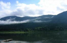
The braid connecting the Black and Azov seas. Kosa Chushka: rest between two seas
Taman is the tip of the Western Caucasus, swept by the gentle breezes of two seas - the Black and Azov. It is logical that the peninsula is a "sea gate" connecting the Kuban with the Crimea. In addition to ferry crossing, a large bridge crossing with different branches will also play the role of a crossing. One of them starts from a long sandbank called Tuzlinskaya Spit. The bridge, however, was slightly bypassed so that the construction site would not ruin the natural and even historical reserve that had formed here, while most of Tuzla would still be under its piles.
Where is Tuzla Spit located?
The island and several dams with this name are located on a conventional line connecting Pavlovskaya Bay of Kerch with a lake located near the westernmost base of the former state farm "Yuzhny". Administratively, it belongs to the Tamansky rural settlement of the Temryuk district.
On the map of the Kuban, the Tuzla spit is located as follows:
Historical facts
Like the rest of the shoals, the longest of them is the result of the activity of tides, storms and strong winds, as well as the rampage of local mud volcanoes. Until a certain time, the geographical object was an elongated peninsula, since it did not lose contact with the continent. And at the end of the last century, this corner became the subject of border claims between Russia and Ukraine.
It is worth starting a conversation about the Tuzla Spit with an excursion into antiquity. During the existence of the Bosporus Kingdom and the Byzantine Empire, this place was not without reason called Akme (in Greek - "edge"). Later, when nomads appeared here, the location received a different name, because in all Turkic languages "tuz" means "flat". The fact is that from the early medieval periods, the ledge was an absolutely flat surface, consisting of sand and silt deposits. All this attracted fishermen to him, who arranged their encampments on the shores of the spit. Here boats and nets were dried, the fishermen themselves warmed themselves before the fires. Gulls and cormorants lived in large numbers.

Tuzla gradually separated from Taman Peninsula during the tornadoes of 1920. It was not possible to restore the connection - nature has always opposed this. Since then, this isolated corner of the Russian Black Sea region has taken on a life of its own. The landscape has preserved hundreds of species of flora and fauna that have already disappeared in other areas of the planet.
Rest on the Tuzla Spit
The sandy beach is made up of fabulous sandy beaches. They can be called the main destination for excursions starting south of Cozy. Many consider this very coastal strip to be the watershed of the Black Sea and Azov. The part of it that belonged to Ukraine was called in the newspapers “the most popular beach in Kerch”.
So the 6.5-kilometer ledge in question is essentially an island - even a few islets. Some of them were recently connected with artificial dams - for the convenience of installing support structures for the bridge crossing.
Most of the photos show the Tuzla spit taken from the side of the main Taman "fishing ground". A conversation about the lake of the same name is the estuary waters overgrown with reeds and reeds, where not only river predators, but also delicious pelengas and mullet, breed at a fabulous pace. Now, however, the noise of the main construction site scares the fish. Fans of "water hunting" bypass this tract.

Today, only areas south of Tuzla are available for swimming - both sandy beaches and comfortable rocky slopes of artificial embankments. This refers to the coastal edge not far from the remains of the said state farm base. By the way, the finished sections of the bridge can be seen well from here. The Tuzla spit itself is a strategic - that is, well-protected - site along its entire length.
However, you can view this miracle of nature from the sea - simply by paying money to the boatman. If you are planning something like a picnic here, then you need to buy drinks and food in Taman. There is nothing for many kilometers around - except for vineyards and trailers for builders invited here from all over the world.
How to get there (drive through)?
The best route here is a small road starting at the end of Karl Marx Street. Minibuses and buses do not run here. The path from the last village farm to the water is 7 km. He walks through the vineyards. On the map, the path looks like this:
Tourist notes
- Address: Temryuk district, Krasnodar region, RF.
- GPS coordinates: 45.237526, 36.599445.
Analyzing the above information, it is not difficult to understand that an amazing vacation is possible here, associated primarily with fishing. In conversations about the best bathing places in Temryuk district, the Tuzla spit also appears. Photos of satisfied holidaymakers just flooded the Internet. Vacationers coming here, in addition to resort relaxation and fish bite, want to get shots against the background of the supporting structures of the first and only bridge connecting the resort Caucasus and Crimea. In conclusion, watch the video about the spit island.
Today, on the world map, you can find two geographical objects with the name "Tuzla". The first point is a cape called Tuzla. But the second location is the one that will be discussed in this article. The full name of the island is Kos Tuzla. The word "scythe" is not accidentally present in the name, because even in the last century this island was really a scythe. An example of such an object today can be a spit called Chushka. It is she who adjoins to In 1972, the Tuzlinskaya Spit in the Kerch Strait became the landing site for the Cossacks of the Black Sea army, after which a rapid population growth began here, and several dozen farmsteads were formed in a short time.
History of the Tuzla Spit
As mentioned earlier, in 1972 the Cossacks of the Black Sea army arrived on the island. At the beginning of the 20th century, farms of the Cossacks were successfully located on these lands, who lived here with pleasure. In the early 30s, it was decided to dig a canal, which was necessary for the convenience of the passage of fishing vessels. But after just a month, a very strong storm occurred in these places, as a result of which the small channel turned into a fairly wide strait. Thanks to this, the Tuzla spit turned into independent island... At the end of the 40s, the island's authorities decided to restore the structure of the former spit. Thus, a special structure was created, with the help of which it was supposed to restore land in a natural way. Special metal piles were delivered with a mesh stretched between them. This idea seemed very good, but, unfortunately, the structure did not justify itself and collapsed already in the first winter. Thus, the island was named the Middle Spit. After its formation, the island became subordinate to the Temryuk region. Krasnodar Territory... But soon the disgruntled inhabitants of the island decided to write a paper on reassignment, and the island began to obey the Kerch City Council. Thus, he was supposed to become part of the Crimean Autonomous Soviet Socialist Republic.
By coincidence, the island did not have time to re-subordinate, as the Great Patriotic War began, and naturally, there was no time for papers. And only 20 years later, the borders were fully restored. But it did not end there, the borders were revised in subsequent years.
The difficult fate of the Tuzla spit

In 2003, the authorities decide to make another attempt to restore the spit. This time, the approach was more solid. An entire dam was erected. The initiative for the construction came from the authorities of the Krasnodar Territory. Thus, between the two states, namely Ukraine and the Russian Federation, there was a conflict over the borders of the states. The bone of contention was the ownership of the island. After a meeting of the authorities of the countries, the construction of the dam was frozen.
In 2005, Ukrainian experts conducted research, during which it turned out that the waves really destroy the island, and soon it may disappear. After these studies, it was decided to strengthen the perimeter of the island with special blocks that will protect it from the effects of waves.
In 2014, for some reason, all Crimean peninsula moved to Russian Federation, therefore, the problem of the Kerch Strait has ceased to be relevant for negotiations between the authorities of the two states. Today, bridges are being built between the spit and the island, which is necessary to preserve the beautiful nature reserve called the Tuzla spit. The bridge connecting the mainland of Russia with Crimea, according to preliminary estimates, will be completed by 2018.

Description of an amazing place called Taman
The Tuzla Spit is covered with stones and limestones, has a fairly fertile soil and is covered with grassy vegetation in places. Nature has created for itself here incredible miracle... The unhewn edges of the dam turned into a smooth and wonderful One and the Tuzla Spit is famous for it. Rest in these places will not leave anyone indifferent. The coast is covered with sand from the sea side, it is very comfortable to rest here. Also on the side of the bay there are small islands where you can also relax in peace, the atmosphere here is wonderful. Limestone stones are immersed in the water, which are brown and yellow, thanks to the sea water, they have acquired more green and blue shades. In the sun, these stones play very beautifully with their color palette.
There is a strait between the spit and the island. Its course is so fast that the islets, which are located at the end, change their shape or location during the season. Such a natural phenomenon very interesting and exciting.
On the seashore, you can always find a souvenir for yourself, the thing is that shells of bizarre shapes and sizes are often washed ashore. It is difficult to find two similar ones, therefore vacationers very often take such gifts of nature home. In particular, these shells delight children. For rest with babies ideal place is Taman. The Tuzla Spit, in particular its banks, is strewn with useful minerals, so swimming in these places is very useful.
Rest on the Tuzla Spit

Despite the fact that the island can be considered artificial, it has long been a part of nature. Its soil is gradually covered with green grass, and every year it becomes more and more. The rugged edges of the dam have long been transformed into a picturesque coastline and have become a wonderful place for a quiet and quiet rest... Small islands on the side of the bay have become a kind of safe haven for wild birds. The stones immersed in the water play with a variety of colors in the sun. Many vacationers take photographs here. This miracle of nature has even become a kind of visiting card of the area. In addition to stones and the sea, this area is rich in other wonderful sights.
The best landscapes for beautiful photos

If vacationers are looking for good view for photographs, this option is ideal. The fast current has created the bizarre shapes of the rocks, and the landscape plays in a completely different way at sunset, so the pictures are especially good. The Tuzla Spit boasts excellent landscapes and an incredible atmosphere.
How to get there
Getting to this area is not difficult, but you still have to overcome a certain path. It is best to ask the locals for directions, people here are good-natured and can even show off. But before you go, you need to clarify the route with the help of maps. The best way to go is by car. If all these conditions are met, the rest will turn out to be simply wonderful.
Spit Tuzla is located near the village of Taman in the Temryuk district of the Krasnodar Territory. It is a well-known and popular holiday destination for both tourists and locals.
Spit Tuzla on the map of Krasnodar Territory
After looking at the photos of the Tuzla spit on the Internet, we decided to go to rest between the two seas. To get to the Tuzla spit by car, you need to drive through Temryuk to Taman. In Temryuk, by the way, you can buy a good one at the factory. When you reach Taman, look carefully at the signs. There will be signs to the scythe. The road to the Tuzla Spit, although unpaved, is quite flat and you can drive any car without difficulty.
On one side of the Tuzla Spit, the sea was muddy and gray, and on the other, dark blue. 
The Spit of Tuzla itself is made artificially. It protrudes in a narrow long strip right into the sea. Its length is about 4 kilometers. They say that the fish on the Tuzla Spit are visible and invisible. I myself did not catch, but there are a lot of fishermen on the spit, both from one side and the other.
There are also enough lovers of spearfishing and diving on the spit. Dolphins often come here, stingrays are found, or as they are also called sea cats, you can find shells - rapana, gobies, mullet, pelengas and flounder. I am telling you from the words of a local fisherman with whom we got into conversation.
Opposite the Tuzla Spit, Ukraine is the Kerch Strait, after all. Mobile phones immediately start working in roaming mode and an SMS comes in, where they congratulate you on your arrival in Ukraine. 
The entry into the sea on most of the spit is not very good. Basically, stones near the coast, large and quite sharp. Putting up a tent is also problematic. There is a very narrow strip of land close to the coast. And stopping right on the road is both inconvenient and unsafe.
But if you go almost to the very end of the Tuzla spit, there will be an already equipped beach. Here entry into the sea is normal and there is a place for tents. But if a strong wind is blowing, it is not very pleasant to stay on the spit. We did not risk it and left for the Taman Peninsula. We stopped in a wonderful place, a small lagoon, where there was almost no wind, and the sea and nature were amazing.
This is a photo of the Tuzla spit from the side of the sea. A long yellow stripe stretched far, far away.
Spit Tuzla long before the construction of the bridge
This article was written in 2009. At that time, no one could have imagined that a super-bridge would be built on this site. Therefore, the text of the article has been left practically unchanged, but it must be read with amendments at the time of publication.
At present (early 2009) two geographical formations are officially named "Tuzla" - Cape Tuzla and Tuzla Island, the full name of which sounds like "Kos Tuzla Island". The word "spit" in the name of the island is apparently present because even at the beginning of the last century this very island was really a spit and, just like now the Chushka spit, was an inseparable part of the Taman Peninsula. It was on the Tuzla spit that the Cossacks of the Black Sea Cossack army landed in 1792, and at the beginning of the 20th century. on the spit there were about a dozen Cossack farms. But in the 20s ...
View of the dumped Tuzla spit
A bit of background
And in the 1920s, more precisely in 1925, at the base of the spit, for the passage of fishing boats, a canal was dug, which, as they thought then, would benefit fishing and would not harm nature (although about nature, as is usually the case, most likely they did not think). Mother Nature looked at these human interventions and ... In general, was she offended, whether she decided to help, but in the same 1925 there was a strong southern storm, as a result of which the channel turned into a strait, and after a while the width of the strait reached several kilometers. So the scythe turned into a separate island.
In the late forties, an attempt was made to restore the scythe. Then piles were driven along the entire length, and a mesh of metal rings was pulled between them. It was assumed that this structure would be sufficient for the formation of land by the forces of nature. However, either the piles were rarely erected, or it was still necessary to first consult with scientists, but the idea not only did not justify itself, but in the very first winter the entire structure was destroyed by the same forces of nature.
If an island is located separately from the mainland, this does not mean at all that a separate, independent life can be conducted on it. No, well, of course, the specificity of remoteness is in itself inevitable, but administratively the territory of the island should be subordinate to someone. And everything would seem as it should be, but in the end ... Well, see for yourself.
After the formation of the island of the Srednyaya Spit (as the island was called in the forties), it, the island, was subordinate to the Temryuk region, Krasnodar Territory. Then, the islanders did not like how the local authorities fulfill their duties, namely they did not like that they were forgotten about during the elections to the local council (as if they had no other problems) and they petitioned for the re-subordination of the spit to the Kerch City Council. In January 1941, the Decree of the Presidium of the Supreme Soviet of the RSFSR was issued on the transfer of the island of Sredny Kosa to the Crimean ASSR.
The bureaucracy in Soviet times also had the opportunity to exist, and therefore, in fact, they did not have time to re-subordinate the island - the Great Patriotic War began. In the post-war years, there were also enough problems. Almost two decades have passed since that decree was issued, and now, in 1958, the Ministry of Internal Affairs of the Ukrainian SSR (by that time Crimea had already been transferred to Ukraine) and the Ministry of Internal Affairs of the RSFSR established administrative boundaries between the fraternal republics precisely according to the decree of 1941.
The administrative boundaries were revised again in the early seventies. What's the big deal? Normal government nomenclature activity. In general, this is how it is, but there is no more that state. It split up into those very socialist republics. And the fraternal Ukrainian SSR suddenly became abroad, and the island of the Middle Spit, and now the Tuzla Spit, is now a foreign territory.
Stop. Now is the time to make a statement. The author of this text does not in any way intend to conduct any political agitation or other political activity. Politics, as they say, to politicians. What am I doing? Moreover, in 2003 the Russian side took concrete steps to restore the Tuzla spit. This is the purpose for which this was done, I will not discuss, so as not to bump into politics and not get away from the story about why this description was actually started.
About the newly dumped scythe

So, the work was in full swing day and night. Trucks with soil, stones and a roundabout for a long time disturbed the sleep of those residents of the village of Taman, along whose streets the route of trucks passed. Well, that's the price of big construction projects. A year later, the bulk spit was tens of meters wide and 4 kilometers long ...
Well, it is no coincidence that the word "politics" was mentioned a little higher in the text. Well, it is impossible in the story about the new Tuzla spit to keep silent about the fact that the construction of the spit acquired a political connotation from the very beginning of the construction, and even at the interstate level. And how do you want with this geographic location... Yes, it could not be otherwise, and they did not pour the scythe further into the sea.
In general, our spit has grown not only by the hard work of the road workers, but also by the temporary hardships of the inhabitants of Taman, and also this is not a secret for anyone, by the political tension between the two states. By the way, if you look at the streamer using the satellite imagery service from GOOGLE, then the underwater relief of the streamer is very clearly visible through the clear water.
Everything. There she is. There is. So what's next? And then the fishermen were the first to go to the dusty, not yet rolled embankment, and they liked this new spit so much that the number of people wishing to fish only grew. And what - you want to throw a fishing rod into the Black Sea, but you want to Taman Bay... The beauty!
A year or two later, yes, in that warm summer, people, young and old, went to the scythe, so as not only to fish for a fish, but also to search, but for the sake of a body of pleasure and soak up the southern sun. And there was a place to soak up in the sun, because every year more and more sand, pebbles and shells were applied from the sea side, and the spit became wider. This is how a natural beach began to appear at the artificial embankment.
The Tuzla Spit and part of the coast at its base became more and more popular among visitors and local vacationers, and this circumstance could not go unnoticed - Tuzla became one of the attractions of the Taman Peninsula, and entry to the spit was no longer free.
During a strong storm in November 2007, on the roadstead opposite Cape Tuzla, one dry-cargo ship sank and broke, but one tanker loaded with fuel oil did not sink. Fuel oil emissions were in many places, including Azov coast, but most of them were on the Tuzla coast. Despite the fact that large-scale and, most importantly, effective work was carried out to collect fuel oil, many predicted the breakdown of the 2008 holiday season throughout the Taman Peninsula. However, already in May, on the spit itself, it was rare where you could find traces of a disaster, and in the middle of summer, the beaches of the spit were already full of vacationers, so the 2008 season, albeit with a delay, took place.
Scythe as a source of beauty
Any artificial earth embankment eventually becomes a part of nature. So the Tuzla spit, which was poured not only from stones and limestone, but also from fertile soil, gradually, although not everywhere, was nevertheless covered with grassy vegetation. The sea and the bay turned the rugged edges of the dam into a full-fledged Coast... From the sea side there are beautiful sandy beaches, from the bay side there are small islands and small spits that have become favorite places wild birds. Limestone stones immersed in water, in addition to their main light yellow-brown colors, also acquired a dark blue-green color. Such a play of colors leaves few people indifferent, and everyone who had a camera with him at least once captured the reflection of the sun on wet stones.
Photos of wet stones in the water or large chipped stones near the water have practically become the hallmark of the Tuzla Spit among Russian Internet users. Most people prefer to pose against the background of stones and the sea, although there are other, equally attractive and beautiful views on Tuzla.

Continuing the theme of species, I would like to draw your attention to the sandy formations that are washed up at the very end of the embankment. The strait formed here, between the spit and the island, has a strong current. Due to this, the islets change their positions and shapes even during one summer. In the evening, when the sun is approaching sunset, and the sea is only slightly rough, the photographs from these small islands are especially successful.


If your camera allows you to take high-quality pictures from a long distance and you are always happy with new shots with our smaller brothers, in the vicinity of the spit and its base there are different species of birds, and closer to the end of the dam, there is an opportunity to watch for a dolphin, and sometimes a whole flock.
On sea beach there are always those who want to collect beautiful shells, fascinating with their patterns, shapes and colors. Unlike the Azov beaches, the discarded shells on Tuzla are noticeably larger and more varied.
Spit as a place to swim
The artificial dam and the coastline in front of it added about 5 kilometers to the total length of the sandy-shell Taman beaches. Thus, Tuzla Spit is the largest paid beach on the peninsula.
Speaking of paid. The checkpoint for collecting money in the summer of 2008 was installed relatively far (more than a kilometer) from the beginning of the dam itself, blocking the only access road to the coast from Cape Tuzla to the base of the embankment spit. For what, in addition to garbage collection, a fee is charged on such a large territory - it is difficult to say, since an equipped beach with everything you need is far from the entrance and occupies a part of the coast no more than 500 meters long. However, the territory is really large and keeping it clean is a laborious task with the corresponding costs, and there is enough garbage during the period of a large flow of tourists.
So, the equipped beach is located almost at the end of the Tuzla spit. It is in the area of this coastal site that there are most vacationers. Here the sea is deeper, and beach strip wider, and service close by. And here you can feel the edge of the earth, and not just the land, but the Russian Land.


On the beach itself, which is called "Kerch Beach", there is everything you need: a dressing room, a toilet, a sun canopy, a tower for lifeguards, a first-aid post, and a mini-cafe. The coastal area is marked with taut ropes with flags, and there are boundary buoys in the sea. On the side of the road, there are stands with information reminding of precautions for swimming.
Attention! The buoys are not installed for the sake of compliance with the rules and requirements, but for your safety. As mentioned above, there is a strong current between the spit and the island, which also affects the near-beach area, therefore it is highly NOT recommended to swim far beyond the buoys, even on an inflatable mattress! Believe me, unpleasant cases have already been noted. In the gully itself (from the end of the spit), swimming is generally prohibited, which, by the way, is indicated by the signs there.
Well, precautions have been taken, now you can enjoy the delights of bathing. In principle, those who are already accustomed to spending the summer on Black sea coast, you will not surprise with the waters of the Black Sea, but nevertheless the Black Sea is a little different here than, say ... well, for example, in Anapa. On the one hand, there are waters here Sea of Azov(albeit insignificantly, through the Kerch Strait), on the other - the waters of the Dinskoy and Taman bays. It is also safe to say that, unlike the same Anapa or, say, the village of Blagoveshchenskaya, Tuzla does not have light green algae found near the Anapa coast. By the way, despite the fact that many do not like them, those who want to pose in front of the camera, wearing a wig made of those very light green algae ... However, we are a little distracted.
Judging by satellite images from GOOGLE, the distance from the sea to the road in the Kerch beach area is more than two widths of the road itself. Thus, the strip of the coast near the water, on which sunbathers are usually located, is located at a considerable distance from the edge of the roadway. This circumstance allows you not to worry that road dust will interfere with enjoying your vacation, since in most cases it, dust, settles much earlier. True, during a strong wind blowing from the side of the bay, dust of course can reach the edge of the water, but at such moments not only dust, but also sand flies. However, such strong winds in summer they are extremely rare, and the sea is usually stormy in such weather.

So, the removal of road dust from the source is another positive factor that attracts people precisely to the area where the embankment ends. Of course, if fans of fast driving restrain their ardor and do not raise dust, then in bottlenecks to have a rest, too, would be nothing so - normal, and so, it can be very dusty there. And the main thing is that along the centerline along the entire road there are signs with requests, they say, "Do not dust Friend!" But no, it's all the same to press on the gazulka and fly like on the asphalt, well, the dust of others, just as fast, they are the judge.
They usually go to the Kerchensky beach for several hours, or for a day, but on the rest of the territory of the spit and in front of it, people who prefer a longer vacation with an overnight stay in a tent are more often located. As a rule, they choose places that are least exposed to dust from the road, and also allow you to park your car as close as possible.
In the area of the base of the spit, the sea is shallow, and in some places even very shallow. Swimming in such a "shallow" is more suitable for children. For some reason, the water in these places warms up well and you can get special pleasure just lying on the bottom. However, do not forget that in water the sun has a stronger effect (lens effect), so you can get sunburn much faster than just on the beach.
In shallow water, you may face another nuisance - the remains of fishing tackle. The fact is that at the foot of Cape Tuzla there is a fishing brigade, and the water area from the cape to the spit is included in the fishing zone for fishermen. The spaced nets are clearly visible from the shore, but the metal rods that may remain after them - alas, not. Therefore, be careful, do not run into the water and do not dive, but first explore the area where you are going to swim. Shallow depths and clear water help you in your research.
And finally
Summing up what has been written here, we can say with confidence that the artificially dumped Tuzla scythe is indeed one of the most interesting places Taman Peninsula from the point of view of nature, and from the point of view of history, and, of course, from the point of view of recreation. From the point of view of politics, it is also interesting, but let them write about it on other sites, and we are closer to romance.
By the way, it is the political side of the spit that is most covered on the Internet, but the other, more pleasant and interesting for vacationers, as it is not very. There are so many reviews about how "they" had a great trip to Tuzla and how they liked it there, but to tell in more detail, it is a great rarity. It is even more offensive when some who have been there still write about the scythe, but write unacceptable things. So, for example, quite often there is a story that the Tuzla spit separates the Azov and Black Sea... It's not true! Look at the map! The Tuzla Spit separates the Black Sea and the Taman Bay, and the Black Sea and the Azov Spit are separated by the Chushka Spit, and if Tamansky and Dinskaya Bay take for a part of the Black Sea!
What will happen to the Tuzla spit, precisely to the spit that runs 11 km under water and includes both the island and the dumped part - time will certainly show. In the meantime, the word "Tuzla" among the guests of Taman Land is most often associated with an artificial embankment, its sandy beaches and transparent sea water off its shores.
This article was written in 2009. At that time no one else
and could not have imagined that a super-bridge would be built on this site.
Therefore, the text of the article was left practically unchanged, but read
it needs to be adjusted for the time of publication. (edit from 18-02-2017)
The Temryuk region is a land of carefully watered vine and melon plantations, dozens of bays and estuaries, mud volcanoes and bright green river floodplains. Our Krasnodar Territory has always been proud of this area. Kosa Chushka is one of the reasons for this. We are talking about a sandbank in the Kerch Strait, 18 km long. An excellent spa vacation... Leisure is designed for the whole family - children are waiting for quite safe entry into the water, as well as gentle sand. The proximity to the road will also please.
Where is the Chushka spit located?
The map gives the traveler an idea of the location of the scenic spit. It begins as an extension of Cape Achilleion and goes southwest at right angles. It stretches towards Tuzla - these shoals are separated by only 6 km of water space.
On the map of the Krasnodar Territory, the Chushka spit is located as follows:
Historical background
Hundreds of years ago, strong storms brought so much sand to the Kerch Strait that several huge shoals were formed here: as well, Chushka once blocked the strait altogether and served as the shortest road from Crimea to the North Caucasus. The name of the attraction was born from local residents in the 19th century. The fact is that dolphins were often thrown at it, and the Little Russians called them porpoises: a pig in their dialect sounds like "chushka".
During the years of Hitler's occupation of Crimea, the Reich Minister proposed building a ferry to the Caucasus here, but the Germans did not manage to do this before the Red Army attacked.
In 1944, the spit was nevertheless connected to the Crimea by a railway bridge - by the forces of Soviet workers. However, a large ice drift demolished this structure in the same year, and new design solutions did not find a response from the then leadership of the country. Today, the elongated and reedy recreation is a gathering place for fishermen and bathers living in the village of Ilyich, as well as car tourists... One of its sections is the territory where the Port Kavkaz ferry is located.
Rest in the west of the Krasnodar Territory
The Temryuk District is a beautiful landscape in the Krasnodar Territory. Kosa Chushka is one of the three main local "business cards", because it is located simultaneously in the Black and Azov seas. Many travelers are striving to visit the sandbank, which is attractive in terms of its outlines and vegetation. Some of them are fishermen, the other half are picnic lovers with intense swimming.

It is characteristic that Chushka is more impressive in width than Tuzla - from 500 to 1000 m. As a result, this geographical object can also be called a peninsula. Its northwestern side is relatively straight, and the southeastern side resembles a horse's mane from above - a huge number of branches branch off from the main coastal massif. The backwaters formed by them in the spring and in the first half of June turn into spawning pits for herring, flounder, crucian carp, pike, goby and ram.
The building material of the "resort" tract is large quartzite and shell rock. Car route and the railway road under construction runs along an artificial embankment - they are protected from flooding. The beaches are located where there is still more sand than vegetation. They are located in the space closest to Ilyich. The entry into the sea is shallow here, but there are equally many shells (with sharp edges) along the entire length.
Additional opportunities in Temryuk district
At the Chushka spit there are two isolated pieces of land - the islands of Krupinina and Dzendzik. They can be reached by any floating facility, which has been used more than once by local couples in love. But the islands of Lisiy and Gollenky are so small that few people know. Here you can safely hide any treasures - the main thing is to find them yourself later.
Some come to the farthest end of the sandy outcropping, thinking that this is where no one will be. However, too many people think so - the south-western patch is packed with cars with Krasnodar and other license plates.

Reviews left online by hundreds of tourists call this place “solid sandy beach"," Sand hidden in the reeds "," fishy spot "," storehouse of beautiful shells "and other epithets. This location is often used by small groups of nudists, but none of their clubs has a permanent beach here. Buy food for a picnic in Ilyich.
How to get there (get there)?
To get to the Chushka spit just take the P-251 highway. It starts from the Krasnodar Western Bypass, passes through the villages of Elizavetinskaya, Maryanskaya, Novomyshastovskaya and Ivanovskaya. Further, the highway goes to Slavyansk-on-Kuban, Anastavievskaya, Kurchanskaya, Temryuk, Peresyp and the village of Ilyich. To more accurately orient you, we suggest a route using the map:
Tourist notes
- Address: Ilyich settlement, Temryuk district, Krasnodar Territory, Russia.
- Coordinates: 45.352476, 36.696242.
In dozens of amateur and professional photos, the Chushka spit looks either like a meadow overgrown with tall greenery, or like a coarse sandy edge of water with small shells sticking out here and there. There is no water at all under the grass, so those who came here for the first time should be careful. In conclusion, as usual, we offer a short overview of the described place, pleasant viewing!