Crimea. Mount Kush-Kaya
Crimea attracts tourists from all over the world. Unique views open from the tops of the mountains. Of course, you can soak up the warm rays of the Crimean sun on the beach for some time, plunge into the cool waters of the Black Sea, but adventures still beckon their heroes. Mount Falcon is waiting for its conquerors, ready to climb its steep slopes. Travelers will be rewarded with a unique landscape - the endless sea and the Crimean picturesque expanses.
Before you go on vacation, you should study the features of mountain routes. Basic information about Mount Sokol will be interesting to know for every adventurer.
general characteristics
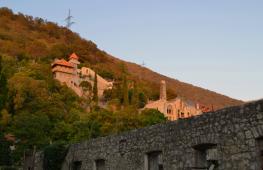
Mount Falcon in the New World is known to many tourists who have visited the peninsula. It can be seen from afar. This is an ancient one that is now dominated by land. In the wreckage, you can see the imprints of sea shells and corals.
At the foot of the majestic mountain is the only road to the New World. Stones from a huge coral reef fall extremely rarely. However, drivers are in awe of the overhanging mass, and they try to slip through this section of the road faster.
At the foot of the cliff there are small bays and several large boulders. They are also called Falcons. They seem to take refuge under the power of their protector.
Mount Sokol, whose height above sea level is 474 m, is the largest coral reef of the Crimean peninsula and the oldest in Europe.
mountain slopes
Mount Sokol (New World) stretched 1 thousand meters wide and 1.2 thousand meters long. This natural object got its name due to its northeastern appearance. Previously, it sounded like Kush-Kaya. From this side, the mountain resembles a bird that spreads its wings. The ancient Romans called her Senator for her imposing appearance.
The slopes on the south side are steep. If it rains, the water rushes down the rock in powerful streams.

At this time, four temporary waterfalls can be observed. They exceed even Wuchang-Su in height. But after the cessation of bad weather, the waterfalls immediately disappear.
To climb to the top, you should start the path from the northeast side. Here the slopes are more gentle.
Climbing to the top
Mount Sokol is waiting for its travelers. Crimea is rich in such objects. But the Falcon must be conquered if you are relaxing in these parts. There are many routes for professional climbers and ordinary tourists.
About two dozen routes have been laid from the south and southwest to the summit. They are characterized by five levels of difficulty. For unprepared people, there is a road through the forest, coming from the New World. From the side of the highway, the path will be more difficult.

The most difficult areas for climbing, accessible only to experienced climbers, are located in the center of the southern slope. They are also called "mirrors". There are no large elements of mountain relief.
The length of the routes is from 150 to 400 m. But you need to prepare for the ascent responsibly.
If the tourist does not have sufficient experience in climbing peaks, you should not choose difficult routes. Even on the safest trails, there is a chance of injury or even getting lost. Therefore, travel should be taken very seriously.

Before the hike, you need to study the chosen route. Shoes and clothing should be comfortable. Otherwise, the ascent will seem even harder. Mount Sokol (New World) is known for its impregnable temper. Therefore, in no case should you leave the trail, try to climb steep slopes without equipment. Such wrong actions can end tragically.
Also, before climbing, you should take water and food with you. Although the routes are not very long, it will not be superfluous to make sure.
New trail
Mount Falcon has many trails. One of the most popular for the average tourist is the New Trail. It starts from the highway leading to Sudak, at the place of its sharp turn. Along the way, pay attention to the signs.
There are many beautiful trees and plants along the serpentine road. On the paths you can meet lizards and birds. Along the way, there are even relic trees that grow only in these lands. Birds such as the hawk, falcon, kite and eagle live here.

After an hour (or even more) of moving up, travelers get to the source. Here you can rest and drink cool spring water. This is the middle of the road. Further paths will be deserted. You need to follow the trail so as not to get lost. You can get lost on this part of the path.
Vertex
Mount Sokol offers a unique view from its top. It is not covered with forest, so it will not be difficult to explore the surroundings from here. From the top of the mountain you can see a vast part of the southern Crimean coast.
In the west you can see the New World, its bay. On the opposite side is Sudak. Here you can see and Far below the foot of the mountain is washed by the waters of the warm Black Sea. This picture is simply mesmerizing.
If the weather is good, you can try to see the distant peaks of Kara-Dag. From the southwest there is the highest plateau of these lands - Babugan-Yailu. Here the highest mountain of Crimea Roman-Kosh rises majestically.
The adventure that Mount Sokol gives its guests will leave a lot of positive impressions about itself. Gorgeous Crimean nature, winding serpentine paths will impress any tourist. The view from the mountain deserves the effort and time spent on climbing.
In Crimea, sonorous and exotic names of natural objects are often repeated and, often, more than once. Kush-Kaya did not escape this fate either. It is noteworthy that there are at least eight mountain peaks with this name, the most famous of which are three. One turned from Kush-Kai into a Cat, acceptable to the Slavic ear. The other is in the New World and is now better known under the name Sokol. Only in the area of the Laspinskaya hollow, the name of the mountain has remained unchanged to this day.
Translated from Turkic, “kaya” means “rock”, and “kush” means “bird”. The peak is located not far from the Sevastopol-Yalta highway, above the Batiliman tract and Laspi Bay, literally covering them from the northern winds, and is part of the huge Kok-Kiya-Bel ridge.
Its name - Ptichya - mountain, apparently, was not given in vain. It is located just on the flight path of birds migrating to warmer climes in winter and back in spring. At the top of the flock, they sat down to rest and regroup, according to ornithologists, before flying over the most dangerous section of the path - open water. At the head flew older and experienced individuals-leaders. Kush-Kaya was especially "popular" among bustards and quails. Lovers of easy prey - poachers - could not miss such a chance, they exhausted the birds, leaving the descendants only memories of the former abundance.
In spring and summer, fogs often visit Kush-Kaya. This process continues until the sea becomes warm. During the day, the ever-increasing sun warms the water surface. Then, according to the known laws of physics, fog is formed, which can hang over the sea in a dense veil for a long time. If the wind turns to land, the fog “storms” the Bird Mountain, flows into the Baidar Valley, and “floods” the vineyards of Balaklava. The picture is extremely beautiful. If the wind is weak, a milky veil hangs over the coast for several days, and the top of the mountain sticks out of the clouds like an island in the ocean.
The height of Kush-Kai is not small 664 m. It is composed of conglomerates of the Upper Jurassic period and marbled reef limestones. The mountain, rising smoothly from the north, having reached its highest point, abruptly breaks down in the south, representing an almost sheer solid wall. The seeming formidable inaccessibility does not frighten climbers at all: now 18 routes of all categories of difficulty with a length of 400 to 700 m have been laid on the array.
The entire lower belt of Kush-Kai with a height of 30 to 100 m has long been a traditional place for training and competitions of climbers and climbers. Many eminent persons were also noted here, such as, for example, Stacey Ellison, the first woman from the United States, who conquered Everest in 1988. This peak can be safely called the "Mecca of Crimean mountaineering", intoxication with freedom and delight from the conquered abyss have already experienced more than one hundred, if not a thousand of those for whom "only mountains can be better than mountains."
In addition, Bird Mountain, like birds once, attracts people who are passionately in love with the sky. The paragliding flight path passes by the southern wall. The area is quite difficult for flights, moving along the top, the air masses flow into the Baidar valley, causing a significant increase in wind. Fortunately, this fact does not interfere with the record holders at all, often flying over the mountain, they fly away to Balaklava and even Fiolent.
Other slopes of Kush-Kai are completely covered with forest - the higher, the higher and denser. In the spring, you can see an incredible abundance of flowers in the forest, among which peonies stand out. The scientific name of this lush, up to 75 cm (!), plant is a three-triple or Crimean peony. According to ancient beliefs, where this large pink flower with white edges grows, there are no evil spirits. But before everyone else, in March-April, the undergrowth literally covers a carpet of snowdrops. White, milky drop flowers appear as soon as the snow begins to melt. Interestingly, snowdrop seeds have an edible appendage and are spread by workaholic ants.
The top of Kush-Kai is absolutely treeless, only green grass and a rare low and bushy juniper enliven the picture. But the views from here are fantastic. You can clearly see the Laspinskaya basin with a bay, a section of the road to Yalta with the Karaul-Kaya rock and an observation deck, the Kok-Kiya-Bel ridge on one side of the route and the Dragon Wing - Azhder-Kanat rocks - on the other, the Baydarskaya valley with the bowl of the Chernorechensky reservoir . In the distance, from the eastern side of Laspi, the bulk of Ilyas-Kaya rises. And right under your feet is the resort Batiliman with all its rest houses and boarding houses, and the sea, huge and boundless, to the very horizon ....
It can be safely assumed that a person visited the mountain since ancient times, the place is ideal for observing the area. Left and material evidence of stay. Hidden among the trees near the summit were the ruins of a small structure built of carefully hewn, diabase-like stone. It is oriented to the east, there is a wooden cross and a sign saying that this is the temple of St. Elijah of the XI-XV centuries. Nearby is a well - either a source or a reservoir, obviously built in the late 19th - early 20th centuries. However, the temple is not mentioned in any credible work on the history of Crimea, and the masonry is relatively fresh.
Nevertheless, this place is quite habitable, the old medieval road from the observation deck and the so-called Turkish glade rises to Kush-Kaya through a couple of medieval villages. On 19th century maps the road rests against the house of the marine engineering department. It is possible that it was built on the foundation of some ancient structure. However, serious research and excavations have never been carried out here, and lovers of wandering with a metal detector have not yet come across anything more interesting than donkey horseshoes.
Today, people are perhaps more frequent visitors to Kush-Kai than birds. Walking along the path, climbing the rocks, paragliding over the top, they reach their cherished goal faster and faster. And only silence, a grandiose panorama around and the horizon, lost in the distance, can stop the inexorable run of time.
(c) Dmitry Shamrey
In the middle of the way from Sudak to the New World, Mount Kush-Kaya stretches up right above the sea coast. Translated from Turkic - Bird-Rock. In ancient times, people represented the rock in the form of a proud bird, ready to fly. Now most often called the peak Sokol. Although it looks more like a harsh guardian of the sea coast.
Useful information:
Height above sea level - 478 m, length along the coast - 1208 m. By origin - this is a giant coral reef, formed 140-160 million years ago at the bottom of the Tethys ocean from colonies of sponges and corals.
Photo Mount Falcon in the New World


Historical excursion to Kush-Kaya
The area near Mount Kush-Kaya is considered an archaeological reserve. The ruins of ancient settlements of the 1st-5th centuries AD have been preserved in the juniper thickets. In the Dmitraki tract you can see a cave monastery and the remains of a temple of the Byzantine era of the 8th-12th centuries. Near the peak of Perch, the burial place of the medieval bishop Stefan of Surozh was found.

Useful information for the tourist
Mountain Viewer Video:
Popular routes to Mount Sokol
Thrill-seekers and thrill-seekers work out their rock climbing skills on the western slope. More than twenty climbing routes with difficulty of 1-4 hazard categories have been laid here.For those who are not looking for adventure, hiking trails from Sudak are offered.
If you go from the side of Sudak, then the path starts near the Devil's Finger rock, goes around it on the left and leads into the thickets of Crimean oaks. Gradually rising up, the path will lead to the southern slope of the mountain. Then along the ridge to the highest point. There is a small recreation area here.
It is even more interesting to climb the Sokol from the side of the New World. A well-trodden path starts from the house-museum of Lev Golitsyn “The House of Champagne Wines Novy Svet”. Local residents and oncoming tourists will always tell you how not to stray from the route.

In archival documents, the name of Mount Sokol has been mentioned since the acquisition by Prince Lev Golitsyn in 1878 of the Paradise estate (now it is called Novy Svet). Guests coming to the estate liked to roam the surroundings. It has become fashionable among noble citizens to take walks through coniferous and juniper groves. The benefits of walking for the purpose of general health promotion, and as a prevention of tuberculosis, were substantiated by the famous professor Sergei Petrovich Botkin. One of the routes was laid to the source of St. Anastasia, further to the top of Sokolenok, and, for the most stubborn, to Mount Sokol.
Another legend says that Golitsyn had an idea to build a castle for his daughter on the top of Sokolenok. Lev Sergeevich has already paved the way from the house to the place of future construction. The insidious plan to ruin the prince prevented the implementation. The road, which in some places has powerful support columns, still exists, it is perfectly visible, it is easy to find.
Useful information for the tourist
Having climbed to the top of the Falcon, orient yourself to the cardinal points and you will find out which peaks are in front of you. In the west, behind the village of Novy Svet, Cape Kapchik and the rocks of Karaul-Oba. In the east, at a glance, Sudak, the Genoese fortress, Cape Meganom. With good visibility, the peaks of Kara-Dag loom. In the southwest, inquisitive minds will consider the huge Crimean plateau of Babugan-yayla and the highest peak of the Crimean peninsula, mountain. To the north of you are the rocks of Perchem and the Frog.
Mountain Viewer Video:
Mount Sokol on the map of Crimea
GPS Coordinates: 44°50'10.00, 34°55'40.00 Latitude/Longitude