Open left menu Northern Mariana Islands. Mariana Islands
Mariana Islands separated by the Pacific Ocean and the Philippine Sea. This is a classic island arc of the Pacific Ring of Fire zone, formed by active subduction (the sinking of the edge of relatively thin oceanic crust under the base of thick continental-type crust) of tectonic plates. To the south and east of the chain of islands lies the deepest Mariana Trench in the world with a depth of up to 11,775 meters (according to other sources - 11,022 meters), which is precisely the visible expression of the plate collision zone. Geologically, Mariana is part of a chain of submarine volcanoes known as the Izu-Bonin-Mariana arc, consisting of almost fifty submarine volcanoes. active volcanoes and 11 old volcanic peaks, whose peaks form the islands of the group.
The northern group of islands (Farallón de Pajaros (Uracas), Asuncion, Pagan, Sarigan and others) is geologically young - most of these islands were formed over the last 5 million years and continue to grow today. The young cones of these islands are high and still active - volcanic eruptions and earthquakes up to magnitude 7 on the Richter scale are not uncommon. The steep slopes of the volcanoes run down to the virtually reefless waters of the surrounding ocean, forming typical volcanic landscapes with numerous lava fields and tongues. Vegetation and animal world are scarce, there are also few natural sources of water (with the exception of quite numerous fumaroles and mini-geysers, which annually release thousands of tons of highly mineralized water into the ocean).
The southern chain of islands (Saipan, Tinian, Agrihan, Rota, etc.) are older volcanic formations, whose age reaches 42 million years. They are also based on the tops of underwater volcanoes that fell asleep many millions of years ago. Here is the most high point country - Agrikhan volcano, or Agrigan (965 m). Over the subsequent time, the underwater slopes of the once formidable volcanoes were actively “developed” by corals, the multi-meter thicknesses of which, raised by tectonic processes above sea level, formed the above-water part of the islands of the southern group. Today, almost all the islands of the southern chain are powerful massifs of coral limestone lying on a volcanic base. Numerous coastal terraces and high cliffs mark the sea level at various stages of island formation, and the shores are mostly framed by young coral reefs that form marginal lagoons.
The natural vegetation of the islands is sparse. The main plant is the coconut palm. Copra and palm oil were the most important export goods and the main source of income for many islanders. The coconut provides food and drinks (in addition to coconut milk itself, even flowers are used, ropes are made from palm fiber, wood is used for building materials, branches are used to weave baskets and mats, and charcoal is made from nut husks and cake). No less important is the fire tree (Brachychiton acerifolius), brought from other islands of Oceania (however, in Lately its role is more decorative), as well as coleus (Coleus), caladium (Caladium) and philodendron (Araceae). But various fruit species brought by humans grow here in huge quantities.
The only endemic mammals on the islands are fruit bats, although they have almost disappeared due to the popularity of their meat in the cuisine of the local Chamorro people. Sambar deer can also be found on Rota, and skinks and geckos are found almost everywhere. But the bird community is quite diverse - the Mariana Islands are home to about 70 species of birds, including the grey-throated fantail (Rhipidura dahli), honeyeater (Meliphaga), Australian tern (Sterna nereis) and the endangered swiftlet (Collocalia). And the waters around the islands are literally teeming with marine life.
In fact, few people know anything about the island of Guam in the distant sea-ocean... Guam is the largest and southernmost island in the Marin Islands chain! We also don’t know much about the Mariana Islands... My story is about the myths and reality of this corner of the Earth!
2
Myth I . Mariana Islands - a blank spot on the world map
"White Spot" is located 3 hours flight from Tokyo or Manila, 4 hours flight from Seoul. The Mariana Islands are located in Micronesia and roughly separate the Pacific Ocean and the Philippine Sea. That is, the seventeen islands of the Mariana archipelago are washed by the ocean on one side and the sea on the other.
Myth II. The Mariana Islands are named after Mariana Trench
Exactly the opposite. The trench is named Mariana because it is located relatively close to the Mariana Islands. From Guam, the largest and southernmost island of the Mariana chain, the depression is only 300 km away.
The islands were discovered during his trip around the world Magellan. This happened in 1521. Fernand called the islands Thieves, because the local residents liked the things on the ship so much that they were not too lazy to steal them.
But already in 1568 the islands were renamed in honor of the Spanish Queen Maria Anna of Austria (wife of King Philip IV).
4

Myth III. Primitive tribes live on the Mariana Islands
The Marian tribes with a matriarchal way of life were described in their chronicles by Jesuit missionaries, who formed their first settlement in 1568. In 1565, the island of Guam became a colony of Spain. During numerous wars and upheavals, Japanese, Spanish and American threads were woven into the history of Guam.
Today, Guam is the most important air hub in Micronesia, the island of two American military bases and an extremely popular resort, visited by more than 1 million tourists annually. The services of the above-mentioned institutions are carried out by the indigenous population, among whom are lawyers, hotel managers, and doctors. By the way, the Department of Marine Biology at the University of Guam trains some of the best specialists in this field of knowledge.

Myth IV. There are many dangerous animals in the Mariana Islands
One of God's dangerous creatures is the tree snake. It is dangerous for birds because it feeds on eggs that it finds in nests. Snakes live in the jungle, are afraid of all noises and are never the first to attack. IN tourist places Where there is hubbub and exclamations of delight, there are no snakes.

Myth V. The Mariana Islands are prone to frequent typhoons
There are two seasons in the tropics - the rainy season and the windy season. The first lasts 4 months - from June to September. Typhoons are possible at this time. But the last strong typhoon passed over Guam in 2000. By the way, in the entire history of meteorological observations in Guam, not a single person died during a typhoon.
IN last years due to global warming air masses gather into a tropical storm not only at the equator, but also in the tropics themselves.
Let’s say that in September 2009, several tropical storms formed near the Mariana Islands and “twisted” into typhoons: one went to Samoa, the second to Japan. A tropical storm, by the way, is a downpour with gusty winds. It copes well with washing cars and glass, it should be noted.
The remaining 8 months of the year in Guam are windy season. Wonderful sea breeze, the wind that drives white clouds across the sky. Of course, it rains from time to time during the windy season, but they are short-lived. And most often the rain comes from just one cloud: there are clouds all around, a blue sky, the sun - and a rainbow under one small cloud!
2

Commonwealth of Northern Mariana Islands Mariana Islands), a state in Micronesia - Western Pacific Ocean, occupies most islands of the Mariana archipelago (14 of 15 islands. The 15th island of the chain is Guam, overseas territory USA).
The islands form two chains - northern and southern, stretching almost strictly from north to south for 736 km (460 miles). Most of the islands in the northern chain are volcanic cones rising above the water (up to 965 m high), some of which are still active. Southern chain - coral and volcanic islands. The largest islands are Saipan (120 sq. km), Tinian and Rota, the smallest is Farallon de Medinilla, with an area of about 0.5 sq. km. km.
The northernmost (uninhabited) island of the archipelago, Mogue, was ranked first in the National Geographic magazine's "Best Wildlife Destination" ranking.
The Mariana Islands mark the dividing line between the Pacific Ocean and the Philippine Sea. To the east of the archipelago lies the Mariana Trench, whose depth reaches 11,775 m.
The total area of the Northern Mariana Islands is 480 square meters. km.
Administrative center - Saipan island
Time: Time relative to Moscow: 6 hours ahead of Moscow summer time and at 7 o'clock - in winter.
Nature: Most of the islands in the northern chain are actually volcanic cones rising above the water (up to 965 m high), some of which are still active. Southern chain - coral and volcanic islands. The largest islands are Saipan (120 sq. km), Tinian and Rota, the smallest is Farallon de Medinilla, with an area of less than half a square kilometer. The Mariana Islands mark the dividing line between the Pacific Ocean and the Philippine Sea. To the east of the island chain lies the world's deepest Mariana Trench, up to 11,775 meters deep.
Climate: Tropical, trade wind. Typhoons are frequent and tend to pass over the islands between August and December. Precipitation is 1800-2000 mm. per year, rainy season - from July to October. Best time to visit the Northern Mariana Islands - during the dry months from December to March.
Political system: The head of state and executive power is the governor, elected by the population. The Legislative Assembly consists of two chambers: the Senate (9 members) and the House of Representatives (18 deputies), which are re-elected every two years.
Population: The population is about 45.4 thousand people (1993), mainly Micronesians-Chamorros, as well as people from the Caroline Islands and the Philippines.
Language: English (official), Chamorro and Caroline dialects are also widely spoken, Japanese and Korean are spoken in most hotels and some shops.
Religion: Roman Catholic Christianity, local religions and cults.
Economy: The basis of the economy of the Northern Mariana Islands is foreign tourism (233.3 thousand tourists in 1988, mainly from Japan) and agriculture. Heat-resistant cereals, coconut palms, sugar cane, breadfruit, coffee, bananas, tomatoes, cotton, and citrus fruits are grown on the islands; raise cattle, pigs, goats; They catch and process fish (mainly tuna). There are deposits of phosphorites, sulfur, iron and manganese ores. The islands' exports consist of agricultural products.
The main foreign trade partners are Japan and the USA.
Currency: U.S. dollar.
Main attractions: The Northern Mariana Islands are often called "America's Best Keeping Secret", implying that the nature, abundance and historical places(especially associated with the period of the "Battle of the Pacific" in World War II) and the ease of accessibility of the islands both from the territory South-East Asia, and from America. Coral reefs, sea fishing, surfing and excellent conditions for passive recreation attract more than 240 thousand tourists a year to these tiny islands.
For some guests, the island of Saipan can turn into a nightmare when vacationing on a package deal, since it is literally overcrowded with tourists from Japan, moving in “organized columns” and constantly clicking the shutters of their cameras; the recreation infrastructure here is relatively poorly developed and is aimed more at lovers of an active lifestyle, than the pampered "shop tourist", but this island is still famous for its charm - there are still plenty of turquoise waters, white sands and excellent conditions for diving, swimming, snorkeling and hiking. Saipan is the most popular place "historical tourism"from citizens Japanese Islands. In the recent past, this has allowed the island to achieve the fastest rate of tourism and population growth in Micronesia, with the construction of new golf courses and numerous resorts springing up around the island. Tourists and foreign workers now outnumber the natives, and the island has lost much of its Micronesian character. However, Saipan still has everything that attracts tourists here - beautiful beaches on the western and southern coasts, many picturesque places on the stormy and rocky east coast, rolling hinterland and majestic cliffs on the northern coast. The island itself has 23 km. in length and 8 km. in width.
Garapan, the most Big city in the Commonwealth of the Northern Mariana Islands, is the fastest developing city region. Almost destroyed during the fighting of World War II and resettled in the 1960s, Garapan has now been completely restored and is completely built up with sushi bars, karaoke clubs and other establishments that are clearly aimed at tourists from Japan. The white sands and turquoise waters of Micro city beach are considered the most beautiful on the islands. Just north of the beach, American Memorial Park stretches along the coast, protecting the habitat of forest and wading birds, and also serves as a favorite place for picnics and memorial events dedicated to the memory of American soldiers killed in the US invasion of Saipan and Tinian. Also located here is the Museum of the Second World War with an exhibition of weapons, uniforms, ammunition, photographs and other military attributes of that time. Tinian is a sleepy island with a single village just 2 km away. south of Saipan, it has "luckily" escaped the main influx of tourists and therefore serves as a good place for "escape from civilization" if the bustle of Saipan seems too intrusive. It is difficult to imagine that such a peaceful place could be involved in one of the most tragic events in history: Tinian became famous as runway for the Enola Gay, the plane that dropped atomic bombs to Hiroshima and Nagasaki. San Jose, main locality islands, is the territory of an ancient Chamorro village. Those early settlers created the finest facilities that are largely what attract visitors to the area today. The main attraction of San Jose is the Taga House, which served as a place of large gatherings and the residence of Taga the Great, the legendary king. ancient state Chamorro.
There are several on Tinian good places for swimming, including Cummer Beach in San Jose and Taga Beach south of the village, which have turquoise waters and white sand. Chulu Beach on the northwest coast of Tinian is the site of fierce fighting during World War II, where American troops landed on the island, so massive archaeological excavations continue here. Rota Island lies halfway between Saipan and Guam, and is only now beginning to “come out of the shadows” big islands, it is still a slowly developing place with poor recreational infrastructure. The main village, Songsong, still has no traffic lights or shopping centers. Located on southwest coast Rota, Songsong stretches along a narrow peninsula, which only at the tip rises to the foot of Mount Taipingo (210 m.). The village is literally “saturated” with a variety of stones, which serve to strengthen the foundations of houses and to mark “streets” and as piers and fences. The local Franciscan Church of Borgia is proud of its hundred-year-old bell. You can travel from Songsong by foot or jeep to the northeast, where the island's shores are particularly scenic, or visit the white coral sands of Twixberry Beach or climb to the top of Mount Taipingo for superb views of the village, harbor and Sasanaya Bay. The Northern Mariana Islands are an excellent place for active type recreation. Saipan has the most interesting place- Grotto (Grotto), a natural cave with underground lakes up to 15 meters deep and tunnels to open sea. You can dive to WWII crash sites in Tanapag Harbor, caves and conger eel breeding grounds at Obian Beach, and huge coral formations just offshore at the Saipan Grand Hotel. The best place for snorkeling on Saipan is Managaha Island, on Tinian - Tachona Beach, and on Rota - Corell Gardens in Sasanaya Bay. All three islands have good conditions for hiking. On Saipan, the main route is the Laderana Tangka Trail through the Marpi Commonwealth Forest. There is a wonderful route along the banks of the Cammer and Taga south of San Jose on Tinian. Other recreational options include windsurfing, which is extremely popular here, ( the best place- Micro Beach on Saipan), tennis, golf and short underwater excursions in the lagoon between Saipan and the Managaha Islands, where you can see on the bottom of the sea, in addition to its many inhabitants, traces of the wrecks of Japanese ships or American B-29 “Superfortresses”. Most villages hold annual celebrations in honor of their patron saint, which are the biggest events of the year. Rota and Tinian each hold one such "festival", while Saipan has six: in San Vicente in early April, in San Antonio in mid-June, in Mount Carmel Cathedral in Chalan Canoa in mid-July, in San Rock in mid-August, Tanapag in early October and Koblerville in late October. The Tinian Festival takes place during the last weekend of April or the first weekend of May in honor of Saint José, the island's patron saint. The largest and most popular festival in the Northern Mariana Islands, however, is the Rota Festival on the first or second weekend of October. The celebration, held by the Franciscan Church of Borgia, includes a luxurious banquet, which features only traditional food and drinks of the Chamorro people, religious processions, music and dance festivals.
Most events and festivals are still held in Saipan. Popular events include the half marathon and 10 km sea race, held at the end of January. The Kintetsu Buffaloes, a professional baseball team from Japan, hold training camps and competitions here in the spring, training and playing with local teams (and at a fairly serious level) during the first two weeks of February. The annual Micronesian Open and Saipan Lagoon Regatta are international windsurfing competitions, as well as the Hobie Cat competition, held in the Micro Beach area in mid-February. International athletes swim, bike and run nearly 80 kilometers during the Tagaman Triathlon, held in mid-May. The week-long Liberation Day Festival celebrates the liberation of the islands on July 4th, US Independence Day. The festivities include pageants, a beauty pageant, a night of varied entertainment, sports games and numerous banquets. The fishing tournament takes place in August during marlin season. Each island also hosts a different fishing competition, with Rota having Labor Day on a weekend in early September and Tinian having the Fishing Prize in early November.
Historical sketch: Since the 17th century, the Mariana Islands have been a colony of Spain. In 1898 Spain sold the islands to Germany. In 1914, Japan captured the Mariana Islands, and in 1945 the Americans came here. After World War II, the Mariana Islands were part of Micronesia, a territory under US administration. In the 1970s, Micronesia was divided into four political-administrative units. One of these units was the Mariana Islands without its southern part (the islands of Guam). In 1975, the islanders voted to become a "freely affiliated" territory of the United States. In 1976, an agreement on free association between the Northern Mariana Islands and the United States was signed. On November 3, 1986, this agreement came into force, which meant the emergence of a new state - the Commonwealth of the Northern Mariana Islands.
National domain:.MP
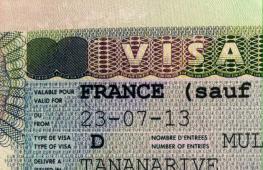
Entry rules: All visitors require visas valid for up to three months and proof of no immigration intent. To obtain a visa, you must provide two completed forms, two photographs, a passport valid for at least 6 months, as well as evidence of the absence of immigration intentions (certificate of salary, certificate of real estate, etc.). Formally, an invitation is not required to obtain a visa. The consular fee is $45, in addition you need to pay the cost of the visa ($20 - one-time). The processing time - from a couple of days ("express") to one and a half months - depends on the documents provided and the appointment of the interview. The visa you receive does not guarantee entry into the United States and the Mariana Islands. Russian citizens are registered upon passing passport control. Immigration authorities at the first point of entry into the country will stamp the date of entry, permitted period of stay in the country, date of departure and visa category on the travel voucher insert.
Customs regulations: The import and export of national and foreign currency is not limited. You can import any amounts in cash, traveler's checks and payment cards. Only amounts over $10,000 are required to be declared. When importing gold, declaration is required. Personal items are not subject to duty; perishable foods, weapons, and drugs are prohibited for import into the country.
The Mariana archipelago is located in the very west of the Pacific Ocean, in almost fabulous Micronesia. Amazing nature and beach holiday in American style with a touch of civilized exoticism - everything about the Mariana Archipelago: map, photos, weather and tours.
- Tours for May Worldwide
- Last minute tours Worldwide
The Mariana Archipelago is the offspring of American democracy. These islands have had no luck with their owners all their lives. Either Spain will take them for itself, then Germany, then Japan. As a result, President George W. Bush, “beloved” by many US residents, united the Northern Mariana Islands with Guam, and the Mariana archipelago thus became the “Stars and Stripes” territory.
The Mariana Islands are another place on earth that is vying for the title of paradise. Once you get here, you realize that the best thing in the world is doing nothing. On one side of this archipelago is the Pacific Ocean, on the other, the Philippine Sea has crept up. Here you can jump from island to island and quickly “sing away” your summer.
Time difference from Moscow
7 o'clock
- with Kaliningrad
- with Samara
- with Yekaterinburg
- with Omsk
- with Krasnoyarsk
- with Irkutsk
- with Yakutsk
- with Vladivostok
- from Severo-Kurilsk
- with Kamchatka
How to get there
There are two important points in this archipelago - Guam and the Northern Mariana Islands. There are no direct round trip flights from Russia. You can fly to Guam with a connection in Tokyo or Seoul, or take a charter through Manila. It will take you about 16 hours to do everything.
You will spend approximately the same time when flying to Saipan - via Shanghai, Tokyo or Seoul.
Search for flights to the Mariana Archipelago
Visa
From October 1, 2019, citizens of the Russian Federation will need a visa to visit the Mariana Archipelago, which must be obtained in advance. In addition, do not forget about a medical insurance policy for the entire duration of the trip.
- Is it possible to go to the Mariana Islands if the period of deportation from the USA has not expired?
- What documents are needed to travel with a child to the Mariana Islands?
Hotels
In the Northern Mariana Islands best hotels located in Saipan. Here a good choice three- and four-star hotels. Accommodation rates start from $90 per night.
In Guam, the center of luxury hotels, shops and restaurants is located in Tumon Bay. International hotel chains operate here - Hilton, Hyatt, Marriott and many others. Most often, near the bay you can find luxury hotels that take huge chunks of cleanest beaches. Cheaper rooms are located a little further inland from the coastline.
Currency of the Mariana Archipelago
The country's currency is the US dollar (USD), 1 dollar has 100 cents. Current rate: 1 USD = 75.12 RUB.
Transport
The Northern Mariana Islands have the most comfortable view transport is an airplane. An indispensable means of transportation given the remoteness of the islands. There is no railway, and public transport is poorly developed. It is best to rent a car or use tourist buses, who stop at the hotel, shops and restaurants.
On Guam from public transport take it easy. 15 people work here bus routes. Buses run every day except Sundays at intervals of 30 minutes. True, drivers will not go anywhere after 7 pm. The trip costs a dollar. Day ticket - $3.
Open-top buses also ply around the island - they are best suited for excursions so that you can examine and photograph the sights in detail.
Beaches
There are several beaches in the archipelago that attract the most tourists. One of the cleanest and most beautiful is Micro Beach. For lovers of snorkeling, Lao Lao Bay is suitable, and for fans of outdoor food, Ladair Beach is a popular spot for picnics. And Paupaw Beach offers playgrounds for exercise.
In principle, anyone can choose a beach to their liking. It is not necessary to go to an area crowded with tourists - within a few minutes you will definitely find a secluded corner where no one will disturb you. The archipelago has enough wild beaches. However, when swimming, you should take into account the strength of the rolling waves, and also watch out for the coral rubble that scratches your bare legs.
Cuisine and restaurants
The cuisine of the Mariana Archipelago is a bizarre mixture of traditions from many countries. This is not surprising given the history of the territory. Each owner left behind a trace of food.
The cuisine incorporates recipes from China, France, Italy, the USA and Japan. Cafes and restaurants serve traditional meat dishes with spicy sauces - fried lamb and beef ribs. Cooks prepare simple soups from poultry meat with corn, rice, potatoes and spinach. Coconut soup with vegetables and curry, as well as broth with tomatoes and minced meat are popular.
Naturally, no self-respecting establishment can do without fish dishes: fish fried over charcoal, boiled, smoked or baked with all kinds of vegetables, served with sauce, mussels, beans or ordinary noodles.
They also make coconut wine tuba on the archipelago - this is the naturally fermented juice of a young coconut with a very specific taste.
Shopping and shops
The Mariana archipelago is a whole heap of souvenirs that tourists buy in tons. This is what vacationers most often take home: souvenirs made from shells and coconuts, hats and bags made from the leaves of tropical plants, textiles and paintings, products made from agate, coral and pearls.
Each store has its own work schedule, but none of them will open their doors on Sunday - they are resting. The exception is large shopping centers who do not want to lose profits.
The archipelago has many duty-free shops selling products from global brands - from Chanel and Louis Vuitton to Gucci and Rolex. Prices here are an order of magnitude lower than in the USA itself.
Payment in stores is in American dollars or credit cards, although cards may not be accepted on remote islands. There are commercial banks on the larger islands if you need to cash a check. When going to a small island, it is best to take plenty of cash with you.
3 things to do in the Mariana Archipelago
- Mastering snorkeling is a type of swimming with fins and a breathing tube. With such equipment you can spend a lot of time in the ocean, exploring the underwater world. Snorkeling is a favorite pastime local residents. Adults and children do it. They will teach you too.
- Attend the Micronesian Arts and Crafts Fair, an event held annually in Guam. Representatives of exotic countries like Nauru, Kiribati and Belau flock here. The highlight of the program is the dance and song festival. The fair is visited by approximately 20 thousand people.
- Save the Guam rail is an endangered species of native bird, otherwise known as a ko-ko. In her honor, the Ko-Ko Road Half Marathon is held every year. People gather and run 20 kilometers, drawing attention to the problem of the disappearance of the bird. You will have to run along beaches and villages, so beautiful landscape ensured during the rescue operation.
Entertainment and attractions of the Mariana Archipelago
Some of the most interesting attractions in Guam and the Northern Mariana Islands.
Chamorro Street
This street is located in Guam. Local residents gather here every evening, play, sing, dance, cook delicious dishes and sell souvenirs. Chamorro is the name of the island's aborigines. Their history, among other things, can be studied from the ancient Latte stones - the columns on which dwellings were built.
Fort Apugan
Fort Alugan is located near the capital of Guam. Here in 1944 there were battles between the armies of Japan and the United States. Hundreds of soldiers are buried in a large meadow, and at the bottom of the sea lie the remains of a German cruiser and Japanese ships. Divers love to go here in search of interesting finds.
Diving
The Mariana Archipelago is a kind of transit point for divers who then go to Fiji, Yap, Truk, Palau. Guam has some good diving spots. For example, near Fort Alugan. Or the famous Kingdom of Black Corals - a large deep-sea reef with a sheer wall going 100 meters deep.
Trekking
For hikers, the best place to visit is the Northern Mariana Islands. The main islands - Saipan, Tinian and Rota - are good for walking. One of the main routes is the Laderana-Tangka trail, which leads through the Marpi Commonwealth forest.
Citizens of Russia, Ukraine and Belarus need a visa to travel to the Northern Mariana Islands in 2020. The visa-free travel regime for the Northern Mariana Islands, as well as Guam and Saipan was canceled on October 3, 2019.
Mariana Trench and Everest - most people remember these names from a school geography course. The first is the deepest point on the planet, the second is the deepest high mountain. Height and depth are measured from ocean level. In absolute terms, the most deep depression overtakes highest peak by a significant margin.
The Mariana Trench on the world map should be looked for in Pacific Ocean northeast of the Philippine archipelago (southeast of the Japanese Islands), it is a semicircular trench approximately 1,500 km long, directed with its convex part to the east. The deepest point of the trench is called the Challenger Deep and is 10,994 meters deep.
The Mariana Trench is named after the adjacent Mariana Islands, which stretch along the western part of the trench. The island of Guam, closest to the Challenger Deep, is located 340 km northeast of it. Coordinates deepest point world ocean: 11°22’23.9″N, 142°35’30.1″E.
The trench is located at the junction of two tectonic plates, and its relief is a relatively flat bottom strip no wider than 5 km between two steep slopes. In some places along its length the bottom has a stepped structure and mountain ranges. The water pressure at the lowest point is approximately 108 MPa, which is 1,072 times higher than normal atmospheric pressure.
The depression was first discovered by the English sailing-steam corvette Challenger during the world's first comprehensive oceanographic expedition in 1875. The depth was then determined twice with results of 8,367 m and 8,184 m, which made it possible to call this depression the deepest on the planet. In 1951, the British scientific vessel Challenger II conducted ocean research in these places.
Using an echo sounder, a depth of 10,899 m was recorded. This point was given the name of the ship. Over the following years, new measurements were taken, the depth was adjusted several times in both directions, the last value of 10,994 m was recorded in 2011.
The difficulty of measuring depth of such scales with an echo sounder lies in the dependence of the speed of sound waves in water on its properties (density, temperature, chemical composition, impurities). These properties vary depending on the depth. To obtain accurate values, it is necessary to take water samples from different depths, analyze them and take the data into account in subsequent measurements.
For the first time, the bathyscaphe Trieste with two researchers on board (US Navy Lieutenant Don Walsh and Swiss oceanographer Jacques Piccard) sank to the bottom of the depression (10,915 m) in 1960. Then, unmanned vehicles made autonomous dives several times, and the Japanese Kaiko probe in 1995 took the first soil samples from a depth of 10,911 m.
In 2012, the famous director James Cameron dived to the bottom alone for the first time in history, staying there for a total of 6 hours. Subsequently, a 3D film about the history of this dive called “Challenge to the Abyss” was released. It's worth mentioning that famous traveler Fedor Konyukhov also announced his intention to dive to the bottom of this depression in 2020.
Fauna of the Mariana Trench
At a depth of over 1000 m, sunlight cannot penetrate; eternal darkness reigns there. Along with colossal pressure, this makes living conditions in the abyss extremely difficult. Nevertheless, the Mariana Trench is inhabited. The bottom is covered with silt, which, as the first samples taken showed, is saturated with shell organisms; huge armored amoebae (up to 10 cm in diameter) were also found here.
In addition to the simplest barophilic bacteria, crayfish, gastropods, sea cucumbers, and fish live here. Even during the first visual observations from the Trieste bathyscaphe, small fish resembling flounder were noticed. The specific conditions make the appearance of many local fish striking: they have huge teeth, eyes rotating in different directions (or lack thereof), and sharp spines instead of fins.
Worms up to 2 m long, which have not yet been identified, are also found here. At such depths there are no algae, and the source of food for protozoa is the remains (detritus) falling to the bottom. Recent studies have shown that the bodies of local small crustaceans contain many heavy metals that are extremely toxic to ordinary living cells.
In general, the fauna of the Mariana Trench has been poorly studied; many scientists believe that species long extinct on Earth can be found there.
For example, the teeth of a giant shark, megalodon, were recently found. It is believed that these monsters, which weighed up to 100 tons, became extinct approximately 2 million years ago, and the age of the teeth found ranges from 11 to 24 thousand years.
The research was constantly accompanied by various mysterious stories: unclear huge shadows resembling dragons appear on the monitors, a loud metallic grinding sound is heard, and once, according to the team of the German deep-sea submersible "Hayfish", on the monitor of the infrared camera they saw a creature clinging to the bathyscaphe with its teeth, they had to scare it off with an electric discharge.
Large islands There are 15, and there are also several small rocks and reefs. The population is about 215,000 people. The nationality of the indigenous people is Chamorro, which is also the name of their language. It is believed that the Chamorros are descendants of ancient settlers from the Philippines. Currently, there are practically no true representatives of this people left; everyone who calls themselves Chamorro is mestizos.
The nationality of the Mariana Islands is not as easy to determine as it might seem. Most south island, Guam, has an independent status, it is an unincorporated organized territory of the United States, that is, the island is not included in the United States, but its territory is considered American, and the islanders (more than 180,000 people) have US citizenship. The capital is the city of Hagatna, located on west bank.
The Northern Mariana Islands constitute a separate administrative entity - the Commonwealth, state status completely similar to Guam (loosely associated with the USA). Main Island— Saipan, the capital is called the same.
The first Europeans to discover these lands were members of Magellan's crew, who dropped anchor here in 1521. The meeting with the aborigines ended with the disappearance of the ship's boat. An annoyed Magellan gave the archipelago the name “Islands of Thieves” (de los Ladrones, Ladrones), which existed until the beginning of the twentieth century.
The islands were immediately declared the property of Spain. A few decades later, colonialists began to come here. As often happened, the missionaries arrived first. It was they who gave the territories modern name in honor of the Spanish Queen Marianna, since then the Mariana Islands have been called that way on the map. Colonization did not go smoothly. As a result of armed clashes and long-term repression, the indigenous population decreased by 30 times 200 years after Magellan's visit.
In 1899, the Northern Mariana Islands were sold to Germany, and at the beginning of the First World War, the entire archipelago was occupied by Japan. In 1944, US troops landed on the island of Saipan, long bloody battles began with numerous casualties, approximately 40,000 local residents alone were killed.
The Americans equipped the island of Tinian military base, from which the bombers that dropped atomic bombs on Hiroshima and Nagasaki took off. After the end of the war, the archipelago was for some time under the control of the UN, and in 1947 it was transferred to the custody of the United States.
US citizens do not need a visa to visit the Mariana Islands, and having an American visa in their passport serves as a pass to these territories for citizens of other countries.
Monetary currency is the US dollar.