Federal States of Micronesia. Abstract Federated States of Micronesia
Micronesia
Federated States of Micronesia
Square: 701.4 sq. km
Administrative division: 4 states (Truk, Kosrae, Pohnpei, Yap)
Capital: Palikir (on the island of Pohnpei)
Official language: English
Currency unit: U.S. dollar
Population: 108.2 thousand (2004)
Population density per sq. km: 154 people
Proportion of urban population: no data available
Ethnic composition of the population: Micronesians of various ethnic groups; the largest group inhabits Truk Island (over 50% of the total population)
Religion: Catholics and Protestants are approximately equally represented
Basis of the economy: agriculture and tourism
Employment: in the service sector - St. 55%; in agriculture - approx. 44%; in industry (processing of agricultural products) – approx. 1.5%
GDP: 277 million USD (2002)
GDP per capita: 2.5 thousand USD
Form of government: federalism
Form of government: presidential republic
Legislature: unicameral parliament
Head of State: the president
Head of the government: the president
Party structures: none
Fundamentals of government
The Federated States of Micronesia (FSM) is located in the western part Pacific Ocean, on the Central and Eastern Caroline Islands, discovered by Spanish sailors in 1528. In 1899, Spain sold the islands to Germany, but during the First World War they went to Japan. Since 1947, it has been a UN trust territory under US administration (as part of the Pacific Islands). In 1986, the islands of Truk, Kosrae, Pohnpei, Yap, as well as the small atolls adjacent to them, received the status of a free association. Since September 17, 1991, the FSM has been an independent state.
The Constitution currently in force was drafted during the period of US trusteeship. On May 12, 1978, it was adopted by referendum, and came into force a year later - on May 10, 1979. In addition to the preamble, it contains fourteen sections and ninety-four articles. The decision to adopt amendments to the Constitution is made exclusively by popular vote.
The head of state and head of government is the president, elected by the senators (see below) for a term of four years. A vice president is elected at the same time as the president. The President and Vice President cannot be from the same state.
Federal legislative power is exercised by a unicameral parliament - National Congress. Four deputies, one from each state, are elected for a term of four years (they occupy a priority position and are called senators), ten - for a period of two years (from Truk - five deputies, from Pohnpei - three, from Kosrae and Yap - one each) .
Executive power is exercised by the government, headed by the president.
Each state has its own constitution, generally similar to the federal one, and also has its own legislative bodies and its own government. The states are led by governors who are elected by the population.
Judicial system
The federal judicial body is Supreme Court, which simultaneously exercises the functions of a court of first instance and a court of appeal. The judges of the Supreme Court are appointed by the head of state, but he must first consult with senators about his choice.
At the state level, there are local Supreme Courts, which are also authorized, in addition to conducting trials in the first instance, to accept and consider appeals. The exception is the state of Kosrae, the smallest of all (it contains no more than 7% of the total population), - there is no appellate division in the Supreme Court of this state.
Local (municipal) courts operate on inhabited atolls.
The functions of constitutional control are exercised by the Supreme Court.
Leading political parties
There are no registered political parties in the Federated States of Micronesia. In May 2007, Emmanuel Mori, a native of the island of Truk, previously, since 1999, a deputy of the National Congress, became president.
The president
Since May 2007 – Emmanuel Mori
This text is an introductory fragment. From the book The Newest Book of Facts. Volume 1 [Astronomy and astrophysics. Geography and other earth sciences. Biology and Medicine] authorWhat is Pohnpei, the largest island of the Federated States of Micronesia, famous for? This small island(an area of less than 40 square kilometers) is remarkable for the diversity of its flora. It is home to 767 varieties of plant species, 111 of which are no longer found
From the book The Newest Book of Facts. Volume 1. Astronomy and astrophysics. Geography and other earth sciences. Biology and medicine author Kondrashov Anatoly Pavlovich author Naumov Yuri Yurievich From the book Encyclopedia of Special Forces of the World author Naumov Yuri Yurievich From the book Encyclopedia of Special Forces of the World author Naumov Yuri Yurievich From the book Encyclopedia of Special Forces of the World author Naumov Yuri Yurievich From the book Encyclopedia of Special Forces of the World author Naumov Yuri Yurievich From the book Encyclopedia of Special Forces of the World author Naumov Yuri Yurievich From the book Great Soviet Encyclopedia (GE) by the author TSB From the book Great Soviet Encyclopedia (KO) by the author TSB From the book Universal Encyclopedic Reference author Isaeva E. L.States of the USA 1. Idaho2. Iowa3. Alabama4. Alaska5. Arizona6. Arkansas7. Wyoming8. Washington9. Vermont10. Virginia11. Wisconsin12. Hawaii13. Delaware14. Georgia15. Western
From the book Great Soviet Encyclopedia (DA) by the author TSB From the book Great Soviet Encyclopedia (MI) by the author TSB From the book Great Soviet Encyclopedia (SB) by the author TSBUnited States of America United States of America (USA). I. General information USA is a state in North America. Area 9.4 million km2. Population 216 million people. (1976, assessment). The capital is Washington. Administratively, the territory of the United States is divided into 50
From the book Great Soviet Encyclopedia (SHT) by the author TSB From the book Memo to USSR citizens traveling abroad author author unknownUnited Mexican States Consular Section of the Embassy: Mexico City, st. Carlos B. Cetina, 12a, corner of Chicontepec, tel. 515-69-70. Consulate General: Veracruz, st. July 5 and 6, 1045, tel.
The Federated States of Micronesia (FSM) is a state of 607 islands in the largest ocean southeast of the Philippines, stretching 2,700 km north of the equator. It occupies the central and eastern parts of the Caroline Islands (the western part belongs to Palau), as well as the Kapingamarangi Atoll.
Geography
Only 40 of the islands are of significant size, the rest are small islets and coral atolls. Only 65 islands are inhabited. In terms of island area (702 km2), the Federated States of Micronesia is one of the smallest states in the world.
The FSM is represented by four states, formed according to a single principle: each consists of one or more big islands of volcanic origin and includes numerous atolls (the only exception is the state of Kosrae, whose territory does not include atolls). Large islands (they are called “high” islands here) are located in a ring of coral reefs. They are mountainous and covered with forest thickets. Small islands are represented by atolls: ring-shaped coral islands with a shallow lagoon.
The FSM has an equatorial climate, and the temperature here is about 30°C all year round. In this part of the Pacific Ocean there is an area where typhoons originate: on average, up to 25 typhoons pass through the FSM islands per year, sometimes catastrophic, with destructive hurricane winds of 240 km/h.
Nature
Nature has generously endowed the islands of this part of Micronesia, unlike many neighboring ones: evergreen tropical forests grow on fertile volcanic soil, part of the land is occupied by savannas, large coral islands are dominated by coconut palms, pandanus, breadfruit and bananas, and mangroves stretch along the coast. Numerous rivers run down the mountain slopes, fed by abundant rainfall: on the island of Pohnpei, for example, there are about 300 rainy days a year.
Story
The ancestors of the current inhabitants of the Federated States of Micronesia settled the islands more than 4 thousand years ago. Before the arrival of Europeans, a special hierarchy with leaders and a caste society developed here. Evidence of existence ancient civilization is " dead city» Nan Madol, built on monumental coral platforms lined with basalt slabs. Residential buildings and temples stood on the platforms. This civilization fell into decline even before the arrival of Europeans, who discovered a society in which money was circulated in the form of large stone disks with a hole in the center.
The Portuguese were the first representatives of the Old World to set foot on the islands in the 16th century. Following them, the Spaniards appeared here - in the 17th century. they declared the islands their possessions, but did not receive actual control over the territories. In 1898, after losing the war with the United States, Spain sold the islands to Germany.
During the First World War in 1914, the islands were occupied by Japan, which forced the assimilation of the islanders, which affected their appearance, language and names. After the war, the territories of the future state remained under Japanese control.
During World War II, bloody battles took place on the islands between American and Japanese troops. In 1945, the Japanese were expelled from Micronesia, and the archipelago came under US control.
For a long time, the islands were governed by the US military administration, until the independent Federated States of Micronesia were proclaimed in 1986.
The Federated States of Micronesia is an archipelago consisting of low coral islands and higher volcanic ones, with mountainous central parts. The volcanic islands are surrounded by lagoons, separated from the ocean by coral barrier reefs of dozens of small islands. There are passages in the reefs through which ocean-going ships approach large islands.
The population of the island republic is almost entirely represented by the peoples of the Pacific Islands. A small proportion of the population are descendants of those born from marriages between Japanese and Micronesians during the Japanese occupation of the islands. The assimilation of the islanders by the Japanese was carried out so categorically that many older people on the islands still speak Japanese.
The traditions and customs of the FSM peoples are almost the same on all islands. Here they still build houses of local pillar construction without walls, the function of which is performed by gable roofs reaching to the ground, covered with palm leaves or mats. In addition, the Micronesians preserved the ancient technology of making wooden boats without a single metal nail. Leaders still play the same important role in the life of the community as in the old days. The ancient clan system has been preserved in the villages, and on some islands even the custom of wearing loincloths and skirts made of plant fibers has remained.
Intensive contacts with the Western world in recent decades have changed the mentality of the younger generation of FSM citizens, who are no longer guided by traditional values, but strive to join the achievements of Western civilization.
Despite the fact that the Federated States of Micronesia formally gained independence back in 1986, they retained the status of “free association with the United States.” Thus, the United States is obliged to provide national defense, and the FSM economy is largely dependent on American economic assistance. The Treaty of “Free Association” with the United States allows citizens of the country to choose their place of residence within the United States, which they actively use when leaving a country that is experiencing serious difficulties.
The country's main problems remain high unemployment, declining fish catches and a high degree of dependence on American aid. The country does not even have its own currency, which is now replaced by the US dollar.
The economy of the Federated States of Micronesia, which has no significant mineral resources other than phosphate, is based primarily on agriculture and fishing. Europeans and Asians brought citrus fruits, cassava, sweet potatoes, various tropical fruit trees, chocolate trees, and black pepper to the islands. Local residents clear small areas of forest for plantations. In addition to fishing, which has caused significant damage to the ichthyofauna of the islands, the population is also engaged in collecting mollusks and crustaceans on the reef.
IN Lately The role of tourism is increasing, and an increasing number of islanders are involved in the service sector (for example, in the production of traditional souvenirs). The development of tourism is hampered by the remoteness of the islands, but the number of people coming to see the beauty of the islands and the “dead city” of Nan Mandol, which has received the fame of the “Venice of the Pacific Ocean,” is constantly growing.

general information
Location: North Pacific.Official name
Administrative staff
: 4 states (Kosrae state - Kosrae island; Pohnpei state - Pohnpei, Ant, Pakin, Oroluk, Mokip, Pingelap islands, Nukuoro and Kapingamarangi atolls; Chuuk state - Namonuito, Namoluk, Laol, Pis, Talap atolls, Pular, Puluwat islands, Kuop, Nama, Losap, Mortlock, Chuuk Islands; Yap State - Yap, Maap, Rumung, Gagil-Tamil Islands).Origin of the islands
: volcanic, coral.: Palikir city (Pohnpei island) - 7000 people. (2009).Languages: English (official), Chuukese, Kosrae, Pohnpeian, Japanese, Ulithian, Nukuoro, Kapingamarangi.
Ethnic composition
: Chuuk, Ponape, Kosrae, Yap, Yap of the outer islands, Asians, Polynesians.Religions: Catholicism, Protestantism.
Currency unit
: U.S. dollar.The most important port: Column (Palikir, Pohnpei Island).
Major airports
: international airports Pohnpei, Chuuk (Chuuk Island), Kosrae (Kosrae Island), Yap (Yap Island).Neighboring countries and territories: in the southeast - , in the southwest - , in the north - Guam and Northern, in the east - Nauru and Marshall Islands, in the west - Palau and.
Numbers
Area: islands - 702 km 2, state territory (including water area) - more than 2.6 million km 2.Number of islands
: 607.Population: 106,104 people. (2013).
Population density: 151.1 people/km 2 .
Urban population: 23% (2010).
Highest point: Mount Dolomvar (791 m), according to other sources - Mount Nana Laud (Pohnpei Island, 798 m).
Climate and weather
Equatorial and subequatorial, trade wind-monsoon type.Two seasons: dry (January - March) and wet (April - December).
Direction of the wind
: from November to December - northeast trade winds, the rest of the year - southwest monsoons.Average annual temperature: +26-33°C.
Average annual precipitation: from 2250 mm to 3000-6000 mm (in the mountains on the island of Kusai).
Relative humidity: 75%.
Frequent destructive typhoons (from June to December).
Economy
GDP: $310 million (2011), per capita - $3000 (2011).
Minerals: phosphates.
Agriculture: crop farming (citrus fruits, cassava, sweet potato, various tropical fruit trees, chocolate tree, black pepper), livestock farming (poultry farming, pig farming).
Industry: food (fish canning).
Fishing (tuna).
Traditional crafts.
Service sector: tourism, trade.
Attractions
■ Pohnpei Island: “dead city” Nan Madol (XIII century), Japanese coastal artillery cannons from the Second World War (Sokes Ridge), Sohes Rock (180 m).■ Kosrae Island: temple of the goddess Shinlaku, ruins of buildings of the 14th century, sunken pirate ship Bully Hayes Wreck (1874), Japanese defensive tunnels in Lelu Hill ( highest point islands), underwater cave Blue Hole (“Blue Hole”), Cape Hiroshi Point, basalt dam between the islands of Kosrae and Lele.
■ Chuuk Island: sunken ships and planes from the Second World War, Mount Tonachau (229 m), Nefo Cave.
■ Yap Island: giant stone “coins”, Tabivol (178m).
■ Ulithi Atoll: remains of sunken ships from the Second World War.
Curious facts
■ The island of Yap was a major German naval port before the First World War, as well as an important hub for international transoceanic cable telegraph communications.■ In 1978, the islands of Micronesia received the status of a “territory freely associated with the United States”; in 1979, the FSM Constitution was adopted, but officially the year of independence is called 1986, when the “trusteeship” of the United States was finally ended.
■ The Federated States of Micronesia has been a member of the UN since 1991, as well as a number of regional organizations such as the Pacific Forum.
■ Most of the inhabitants of the island of Pohnpei are monochromats (monochromasia is congenital complete color blindness; a person suffering from monochromasia distinguishes colors only by their brightness). The reasons for this phenomenon in this particular region have not been precisely established.
■ Since the 18th century. the islands of Micronesia began to be visited by trade and scientific Russian ships. In 1828, the Russian navigator, geographer and admiral F.P. Litke (1797-1882) discovered the islands of Ponape (Pohnpei), Ant and Pakin and named them in honor of Admiral D.N. Senyavin - Senyavin Islands.
■ Under the terms of the Compact of “Free Association,” the United States allocated $1.3 billion to the FSM between 1986 and 2001. Then the amount of annual assistance was reduced, but constant multimillion-dollar cash flows from the United States were promised until 2023.
■ Micronesia is a general name for groups of small islands in Oceania, in the western part of the Pacific Ocean, north of the equator, about 1,500 islands in total. The name "Micronesia" literally translates from ancient Greek as "small island".
They are located in the waters of the Pacific Ocean, just north of New Guinea, and are part of the Caroline Islands archipelago. The country belongs to the geographical region of Oceania and has an independent status, but at the same time plays the role of an Associated State in alliance with the United States of America, largely dependent on their economic assistance.
Peculiarities
The Federated States of Micronesia consists of 607 islands of varying sizes, some of which are connected by causeways or bridges. However, only 65 islands of the archipelago are inhabited, and a significant part of the territory is privately owned. The main activities of the islanders are agriculture, fishing, livestock raising and the production of wooden ships. Tourist destination It is poorly developed here due to the remoteness from the outside world and limited financial opportunities. The largest islands are of volcanic origin and abound in mountainous heights, the surface of which is covered with dense forests. All land areas are surrounded coral reefs and atolls. The underwater world is extremely rich and diverse. The forests are home to many rare animals and mammals. When staying in Micronesia, you should take into account the peculiarities of the local culture and try to comply with generally accepted norms of behavior. In particular, the islanders do not like to be photographed or filmed, although due to their mentality they are very sociable and always hospitable towards foreigners.
general information
The main religions in the archipelago are Catholicism and Protestantism. The area of the territory is just over 700 square meters. km. The population is about 110,000 people. The official language is English, although in addition to it there are several other local dialects. The main currency on the islands is the American dollar. Time zone +10. Local time ahead of Moscow by 7 hours. Telephone code countries +691.
A brief excursion into history
The first Micronesian settlements began to appear here around 2,000 BC, and the local residents were divided into various social groups that had unequal status. Civilization came here in 1527, when the first Spanish ships appeared in the coastal waters of the Caroline Islands. At the turn of the 19th and 20th centuries, Germany bought these lands from the Spaniards. During the First World War, the islands were captured by the Japanese, who established sugar cane plantations here. A few decades later, after the end of World War II, the Americans occupied the archipelago, and in 1986 the Federated States of Micronesia acquired the status of a sovereign state in free association with the United States, with the latter taking on the burden of ensuring security and financing the FSM.
Climate
This Pacific region is dominated by an equatorial and subequatorial climate with minor seasonal variations. During the whole year average temperature The air on the islands ranges from +25 to +35 degrees, and it often rains. From August to December, typhoons with strong hurricane winds hit the territory of Micronesia. The greatest part of precipitation occurs in April, when tropical downpours pour down like a continuous wall. The most acceptable times of the year to visit the FSH are the periods from January to March and from the second half of May to July, when the likelihood of natural disasters is minimized.
Visa and customs regulations
When visiting the country for less than 1 month, you do not need a visa. In this case, each state is considered separately and the period of 30 days is counted again from the moment of crossing the border of any of the 4 administrative territories. All 4 states have a customs border, where generally accepted customs standards apply regarding the transportation of certain goods. There is no Russian embassy in Micronesia, and the nearest one is located in the Philippines.
How to get there
Each of the FSF states has its own international Airport, and the island of Yap has a deep-sea port that regularly receives large ocean liners. There are no direct flights with the CIS countries, so you can get to the archipelago by air either from Tokyo, Japan or from Manila, Philippines. There are also flights from the Hawaiian Islands (Honolulu Airport) and the island of Guam, also part of the United States.
Transport
Within the country, private buses and taxis are actively used as the main means of transportation. Public transport missing here. There is regular communication between the islands. ferry service. If you wish, it is worth renting a car, especially since the prices for this type of service are quite reasonable.
The most interesting
Administratively, the FSM is divided into 4 states: Chuuk, Kusai, Pohnpei and Yap. Each of them has several islands and atolls, while having its own administrative center. The most populous state is Chuuk. It is home to over 53,000 islanders. The capital of Chuuk is the island city of Veno, which has its own airport, several hotels and excellent diving conditions. The state of Pohnpei is home to the capital of the entire country, the city of Palikar, with a population of about 20,000 people. It is located on the island of Pohnpei, part of the state of the same name. This area of land is considered one of the wettest on the planet. More than 7600 mm of precipitation falls here annually. The surface of the island is replete with an abundance of coconut palms and pandanus trees, and mangroves grow along the coast. Not far from Palikara is the city of Colonia, which has a developed tourist infrastructure, including hotels, restaurants and entertainment venues. The ruins are the main attraction of Pohnpei ancient city Nan-Madol, related to the origins of megalithic culture. The third state of the country, Kusai, includes several land areas, including the island of the same name with the local capital Tofol, which is geographically considered the most eastern point Carolina Archipelago, near Hawaii. The fourth state of the country, Yap, consists of 4 large islands, 7 small and several dozen atolls. It is known for its distinctive culture and ancient traditions. In addition, the local lagoons offer excellent conditions for scuba diving, and island shores ideal for hiking and admiring the ocean views.
The main advantage of the Federated States of Micronesia is its magnificent natural landscapes and ocean expanses, so revered by numerous diving and snorkeling enthusiasts. To explore the underwater beauty of the local atolls and coral reefs, you can use any island or tiny piece of land by going there by boat or boat. On the island of Veno, Mount Tonachau attracts attention with a picturesque waterfall and ancient petroglyphs on the walls of mysterious rock caves. In addition, fragments have been preserved here military equipment and bunkers for Japanese soldiers who took refuge on the island during World War II. Since then, a lighthouse has risen on the coast, with a lighthouse equipped on it. observation deck. Original traditions and the culture of Micronesia is most clearly represented on the island of Yap, where you can see the ancient stone money of the islanders and enjoy the dancing of local beauties dressed in national costumes. On the islands of the state of Kusai, in the thickets of the tropical forest, you can see traces of ancient civilizations, including partially surviving fragments of the temple of the goddess Shinlaku and the ruins of Menka, with medicinal plants growing along them.
In the state of Chuuk, a real find for diving enthusiasts is the unique Truk Lagoon, which is a free underwater museum, where instead of the traditional shining, well-kept halls, fans of deep-sea diving are offered a real sandy battlefield, dotted with the remains of guns, planes and ships that sank during the battles of World War II war. There is a circular highway running along the entire coastline of Pohnpei Island, allowing you to easily get to its most picturesque places. Here, first of all, Mount Nana Laud is notable, its height reaches 800 meters. Several dozen rivers originate from it, cutting the island territory. Along them there are many waterfalls, the most famous of which are Keprohi, Sauvartik and Lidudunlap. These places are recommended for lovers of eco-tourism, especially since comfortable campsites are located right among wild natural landscapes, allowing travelers to have a good rest and relaxation. Like all other regions of the archipelago, Pohnpei is distinguished by a wealth of animal life, and in the local waters among the vegetation you can see anemones, soft, hard and fire corals. As you dive, you will often encounter common Pacific marine life such as sharks, manta rays, sea turtles and all kinds of tropical fish. The islanders celebrate several national holidays throughout the year. They are held very fun and solemnly, so if you are in the country on one of these days, you should definitely experience such an event in order to become imbued with the culture and traditions of this amazing people.
The Federated States of Micronesia is one of the most remote, and therefore attractive, countries in the world. It has a lot of advantages and even if it is not a popular tourist Mecca on a planetary scale, it arouses genuine interest among travel lovers and serves as an excellent reason to get acquainted with distant and mysterious shores, lost in the vast waters of the Pacific Ocean.
The Federated States of Micronesia is a country located in Oceania, near the Caroline Islands archipelago. Its territory consists of islands in the North Pacific Ocean, which are located near Hawaii and. The total area of the country is 702 sq. km. Coastline is 6112 km.
The country's territory is represented by islands (high mountainous islands are replaced by low ones), coral atolls, and volcanic outcrops. The four main island groups consist of 607 islands.
Map of the Federated States of Micronesia
The country has rich vegetation with various unique species. The slopes above the volcanic islands are characterized by heavy tropical vegetation, including tropical hardwoods. Various types of tropical plants and flowers grow in the forests of Micronesia. Coconut palms grow on coral atolls. The country's flora includes: hibiscus, orchids, banana, eucalyptus, mahogany, ironwood, papaya, plumeria. The fauna is represented by various species of birds, tropical bats, rare species of deer, lizards, which can be found in different parts of the country. Several species of turtles and stingrays live in the waters of Micronesia. In addition, other species live here, such as marlin, tuna, barracuda, and sailfish. Representatives of marine fauna live in the open sea, on reefs, lagoons and coastal areas. Natural resources: timber, deep sea minerals, phosphate.
The climate of Micronesia is tropical. It is typical for him a large number of precipitation all year round, mainly in the east of the country. In the south there is a typhoon belt that sometimes causes serious damage.
The Federated States of Micronesia is a constitutional government in free association with the United States. The head of state is the president, who is also the head of government. The Cabinet includes the vice president and the heads of eight executive departments.
Administrative division - 4 states. The capital is Palikir. The most big cities: Weno (Chuuk State), Colonia (Yap State), Colonia (Pohnpei State), Tofol (Kosrae State).
The country's population is 106,104 people. The people living in the country are mainly Chuuk (48.8%), Ponape (24.2%), Kosrae (6.2%), Yap (5.2%), Yap of the outer islands (4.5%), Asians ( 1.8%), Polynesians (1.5%). English - official language. Religion: Roman Catholics (52.7%), Protestants (41.7%), others (3.8%). Literacy - 91% men, 88% women. Urban population: 23%. Population density: 160.41 people/km². Average age: for men - 22.8 years, for women - 24 years. Average life expectancy: 70.09 years - men, 74.16 years - women.
The country's economic activities are based on subsistence agriculture and fishing. The islands have several known mineral deposits. There is potential for tourism development. But this development is slowed down by isolation, lack of adequate facilities, as well as restrictions in water connections, so most tourists prefer other options to holidays in the Federated States of Micronesia, for example, a tour to Alanya. Under the terms of the original treaty, the US provided $1.3 billion in grants and assistance from 1986-2001. The government is funded primarily by the Compact and aid provided by the United States.
Exported goods: fish, clothing, bananas, black pepper, betel nut. Export partners: Thailand, Japan, USA, Hong Kong, China. Imported goods: food, industrial goods, machinery and equipment, drinks. Import partners: Thailand, USA, Japan,
MICRONESIA
Federated States of Micronesia (FSM), a state in the northwestern part of Oceania between 0 and 14° N latitude. and 136 and 166° E. (2500 km from west to east), occupies 607 islands of the Caroline archipelago (except for the islands of Palau, or Belau, in the west). Consists of four states: Yap, Chuuk (formerly Truk), Pohnpei (formerly Ponape) and Kosrae (formerly Kusai). The total land area is 700.8 square meters. km, more than half of it is occupied by the state of Pohnpei. Only 40 of the 607 islands are significant in size. The largest of them are islands with the same names as the states. The capital is the city of Palikir on Pohnpei Island.
- Federated States of Micronesia. The capital is Palikir. Population - 109 thousand people (1996). Area - 700.8 sq. km. The highest point is Mount Nana Laud (on Pohnpei Island, height 798 m). Main languages: English (official), Japanese, Trukian, Pohnpei, Kosrae. The main religion is Christianity (Catholicism, Protestantism). Administrative division: four states. The monetary unit is the US dollar. National holidays: the same as in the USA; own - Constitution Day - May 10, Micronesia Day - July 12, United Nations Day - October 25.
Flag of the Federated States of Micronesia
On the map of Oceania
Based on their geological structure, they distinguish between low coral islands, rising 3-5 m above sea level, and higher volcanic ones (Yap, Chuuk, Pohnpei, Kosrae), with elevated mountainous central parts. Volcanic islands are surrounded by lagoons separated from the ocean by coral barrier reefs, often consisting of several dozen small islands. Many reefs have passages that allow ships to approach large islands.
The state of Yap (121.2 sq. km) includes seven small and four large islands (Yap, Map, Rumung, Gagil-Tomil) and 134 atolls, stretching from west to east over 1,100 km. Yap Island is characterized by hilly terrain with a maximum height of 178 m (Mount Tabiwol) and fertile soils. It is surrounded by a barrier reef. Most of the population of the state of the same name lives on the island of Japan. The administrative center of the state is the city of Colonia. The largest atoll of the Caroline Islands, Ulithi Island (8 sq. km) consists of 40 small islands. Fais Atoll in the Yap group is famous for its phosphorite reserves.
Chuuk State, which occupies a central position in the FSM, is located 1440 km east of Yap and consists of 15 small island groups (total land area 118 sq. km), scattered in the Pacific Ocean over a 480 km latitudinal direction in the north and 960 km - in the south. The state also includes the atolls of Namonuito (second in area in the world), consisting of 10 islands, Namoluk (triangular in shape), Laol, Pis, Talap, the islands of Pular, Puluwat, Kuop, Nama, Losap, Mortlock (100 islands in three groups - Etal, Lukunor and Satawan). The Chuuk Islands themselves are a compact group of 14 mountainous islands of volcanic origin (Moen, Tol, Dublon, Fefan, Uman, etc.) with a total area of 72 square meters. km, surrounded by a coral reef. Main city Chuuk Moen State is located on the island of the same name. Lagoon surrounding the 14 central islands of the Chuuk group with an area of 2000 square meters. km, serves as an excellent harbor for the port on the island of Dublon. Settlements are confined to the coasts of the islands.
The state of Pohnpei (land area 345.4 sq. km) occupies the most large island, surrounded by a reef consisting of 2.5 dozen islands, half of which are of volcanic origin. The state also includes the islands of Ant (2 large and 12 small), Pakin, Oroluk (with small islands), Mokil (Urak, Manton, Mokil islands with excellent timber and several hundred small ones), Pingelap (Pingelap itself, Takai and Tagulu , united by one reef), as well as two isolated atolls, Nukuoro and Kapingamarangi (also known as Greenwich).
Soils about. Pohnpei is fertile, with lush forest cover the slopes that rise straight from the shores up to Mount Nana Laud (798 m), located in the center of the island. Numerous rivers and springs originate from it. drinking water. On this island is the capital of the state, Palikir, with the residences of government and congress, a modern airport and seaport. The administrative center of the state is the city of Colonia.
The state of Kosrae (109.8 sq. km) is located on the island of the same name and the surrounding reef in the extreme east of the FSM. The island is mountainous with a highly dissected topography (the highest point is Mount Finkol, 634 m above sea level), covered with thickets of excellent timber. The soils are fertile. There are significant reserves of river drinking water. The island of Kosrae is surrounded by a reef and has four convenient bays (Okat, Lelu, Taf and Utwe). The main settlements - Tafunsak, Lelu, Malem and Utwe - are located on the coast and are connected by an unpaved road. The main city of the state is Lelu. There is local air service to Pohnpei. The airport is operational.
The FSM climate is equatorial, more humid in the east of the archipelago, where the cyclone zone passes. Conventionally, two seasons are distinguished: dry (January - March) and wet (April - December). The part of the Pacific Ocean where Micronesia is located is an area where typhoons occur (on average there are up to 25 typhoons per year). Typhoon season is from August to December.
From November to December, northeast trade winds predominate; the rest of the year, southwest monsoon winds blow, bringing heavy precipitation. Pohnpei has an average of 300 rainy days a year. The average annual precipitation is 3000-4000 mm. Seasonal fluctuations in air temperature are insignificant, average monthly temperatures are 24-30° C. The length of daylight hours is the same throughout the year.
The vegetation is represented mainly by virgin moist equatorial forests on the mountain slopes. On volcanic islands it is significantly more diverse than on coral islands. The coasts of volcanic islands are often covered with mangroves. On both types of islands, coconut palms, breadfruit trees, pandanus trees, and bananas grow. Europeans and Asians introduced citrus fruits, cassava, sweet potatoes, various tropical fruit trees, chocolate trees, and black pepper.
The land fauna is not very diverse. Bats, rats (brought on ships by the first Europeans), and lizards are represented. Many types of birds. The fauna of the ocean is extremely diverse and rich, including many species of fish, crustaceans, bivalves, dolphins, and sometimes whales and dugongs.
POPULATION
109 thousand people live on the FSM islands. About half the population lives on the islands of the state of Chuuk - 52.3 thousand people, in the state of Pohnpei - 33.7 thousand, Yap - 11.2 thousand, Kosrae - 7.3 thousand (in the latter state the average age does not exceed 20 years). The FSM's accession to the Compact of "Free Association" with the United States allows citizens of the country to freely choose their place of residence within the United States. Currently, in the USA (on the island of Guam, the Hawaiian Islands and on the mainland) approx. 15 thousand FSM citizens.
The average population density in the country in 1994 (latest census data) was 150 people per 1 sq. km (in the state of Chuuk - 420, Pohnpei - 98, Yap - 94, Kosrae - 66). As a rule, it is higher by volcanic islands(the exception is Nama Atoll, which has an area of 0.7 sq. km and is home to 1,020 people). The birth rate in the FSM in 1994 was more than 20 per 1000 inhabitants (average female fertility 4.7, in the state of Yap -3.7, Chuuk - 5.6, Pohnpei - 4.4, Kosrae - 4.2), mortality - 3, 4 per 1000. Infant mortality - 46 per 1000 births. Life expectancy is 62.5 years.
Average life expectancy is 69.13 years. Population growth in 2003 was 0.04%. The birth rate reaches 26.47 per 1000 inhabitants, the mortality rate is 5.1 per 1000. The emigration rate is 20.98 per 1000. Infant mortality is 32.39 per 1000 births.
The Compact of “Free Association” with the United States allows citizens of the country to freely choose their place of residence within the United States. Currently, in the USA (on the island of Guam, the Hawaiian Islands and on the mainland) approx. 15 thousand FSM citizens.
The ancestors of the modern inhabitants of the Caroline Islands come from Southeast Asia. Racially, they form a special group, formed as a result of the mixing of Australoid and Mongoloid elements. The atolls of Nukuoro and Kapingamarangi are inhabited by Polynesians. Ethnically, there are 9 groups.
Ethnogenesis and occupations of the population.
The ancestors of the modern inhabitants of the Caroline Islands come from Southeast Asia. According to the latest theories, Micronesia was settled in two ways - through the islands of the Malay Archipelago, and possibly the Japanese Islands, and also through Vanuatu (formerly the New Hebrides). The inhabitants of the Caroline Islands, like all Micronesians, form a special group racially, formed as a result of the mixing of Australoid and Mongoloid elements. They are characterized by fairly dark skin, wavy, straight and curly hair, and average height. The appearance of some Carolinians also contains Japanese, Chinese and European features. The atolls of Nukuoro and Kapingamarangi are inhabited by Polynesians.
The traditional occupations of the local population are fishing and farming. Small areas of forest cleared from forest are used for the cultivation of coconut palms, breadfruit, pandanus, yams, sweet potatoes, cassava, bananas, taro, and sugar cane. Currently, citrus fruits, various fruits (pineapples, papaya, mangoes, etc.), chocolate trees, and peppers (black and betel) are also grown. The population also engages in fishing and collecting mollusks and crustaceans on the reef. In recent years, employment in the tourism business (hotels, restaurants, agencies) and airports has been growing. In the cities, Carolinians work as petty employees and are engaged in handicrafts, in particular, making souvenirs.
Language and writing. The official language of the FSM is English, which is also the language of interethnic communication. The languages of the indigenous population of the archipelago belong to the Eastern Oceanic group of the Oceanian branch of the Austronesian family - Yapese, Woleai, Ulithi and Sonsorol, Carolinian, Truk, Kosrae, Nukuoro and Kapingamarangi. The last two are Polynesian languages. The writing of local languages is based on the Latin script. English is taught in all schools. Many older people speak Japanese.
Confessional composition. The overwhelming majority of the population is Christian, with approximately equal numbers of Catholics and Protestants. In some states Protestants predominate (over 98% in Kosrae), in others - Catholics (Chuuk State). Less than 1% of the population adheres to local traditional beliefs.
POLITICAL SYSTEM
The FSM is a federal state headed by a president, in a relationship of “free association” with the United States. The President and Vice-President of the country are elected by members of the FSM National Congress from among their members, but the latter cannot come from the same state as the President. The population of the states elects the governor and local legislature. The country's unicameral legislative body, the National Congress, consists of 14 deputies. Four of them (one from each state) are elected by the population every four years, the remaining 10 deputies are elected for a two-year term (in proportion to the number of residents of the states (Chuuk - 5, Pohnpei - 3, Yap and Kosrae - one deputy each). Based on the election results 1999 Leo A. Falk became the president of the country, and Redley Kilion became the vice president. The president appoints the cabinet of ministers. There are no political parties in the FSM. The military protection of the FSM is provided by the United States.
The FSM is a member of the UN (since 1991), as well as a number of regional organizations, such as the Pacific Forum.
Formalities and rules for entry into Micronesia
Visas to Micronesia
For tourist trips to Micronesia for up to 30 days, a visa is not required. It is worth noting that the 30-day period begins to count again every time the tourist moves to another island group. When crossing the border, you must present a passport valid for at least 120 days from the end of the trip.
Customs regulations in Micronesia
The import of food products that have not passed special sanitary and hygienic control is prohibited. Fruits, vegetables, wood products, plants and seeds are subject to inspection. The export of samples of state-protected plants and animals, eggs and stuffed birds, as well as items made of leather, bone, bird feathers, shells and corals is prohibited.
ECONOMY
Gross domestic product (GDP) in 1989 was the highest in the history of the FSM and was estimated at $145 million, or $1,465 per capita (ranging from $2,107 in Yap to $1,056 in Chuuk). Since then, there has been a steady decline in this indicator.
Agriculture is the most important sector of the economy, providing 60% of the food the country needs and employment of almost 50% of the working population all year round or at least during agricultural work. The country is dominated by traditional semi-subsistence farming, which mainly uses manual labor. They grow coconut palm, breadfruit, pandanus, yams, sweet potatoes, cassava, bananas, taro, citrus fruits, papaya, mango, chocolate tree, pepper (black and betel) and other crops. In addition, goats, sheep and buffalo are raised on Pohnpei. Some agricultural products are exported, mainly coconut products. Its shell is used by the population as fuel. In Yap, brooms, brushes, ropes and mats are made from coconut shell fibers. The coconut palm forms the basis of life for the islanders. In traditional life, coconut palm leaves were used for roofing, weaving mats, baskets, fans, and the nut kernel was used as a valuable food product.
Citrus fruits are grown in Kosrae, bananas, vegetables, fruits, and betel pepper are grown in Yap. The cultivation of black pepper on the island of Pohnpei is acquiring a plantation character (40 hectares of land are allocated for it). The chocolate tree is cultivated on the islands of Chuuk, Pohnpei and Yap.
In recent years, the role of fishing in the country's economy has been increasing, since ocean resources within the maritime economic zone (2.6 million sq. km) are the property of the FSM. Licensed fishing in the waters of the FSM is carried out by Japan, Taiwan, South Korea, Mexico and USA. The approximate market value of tuna caught annually is approx. $200 million
The Micronesian Maritime Department and the National Fisheries Corporation were created to regulate the protection and exploitation of marine resources within the FSM maritime economic zone, support the development of marine fisheries and the priority of domestic fisheries. The Micronesian Maritime Academy operates in Yap, training personnel for the development of fisheries.
Foreign tourism is developing in the FSM. Every year the country is visited by approx. 25 thousand tourists, mainly from Australia and Japan. The main export items are copra (more than 50% of the export value), pepper (black and betel), fish (mainly tuna), trochus shells, coconut derivatives (edible and cosmetic oil, soap, creams), and local handicrafts. Export income amounts to 13-15 million dollars per year. FSM imports up to 40% of food products, industrial goods, cars and other machinery, and petroleum products. FSM foreign trade is characterized by a significant predominance of imports over exports.
The FSM budget consists of taxes, exports of agricultural products, seafood, and licensing of tuna fishing by foreign countries in the FSM marine economic zone. The FSM's main trading partner is the USA. In addition, the Compact of "Free Association" with the United States provided a package of financial assistance that contributed to the FSM's economic progress and guaranteed the sustainability of democracy in the country. On November 3, 1996, the last five-year agreement on US financial assistance was signed. According to it, the volume of assistance in 1996-2001 was reduced to 40 million dollars per year (in 1986 - 60 million dollars, in 1991-1996 - 51 million dollars). Other donor countries (Japan, China, Australia) also have FSM assistance programs, but they are significantly less than US investments.
SOCIETY AND CULTURE
Education. According to the FSM constitution, education is financed from the central and regional budgets. Primary and secondary schools are owned by the state and religious missions. State governments provide basic education and teacher training, while central governments support and coordinate education at all levels. Young people receive vocational education at the Micronesian College in Palikir (opened in 1972, with faculties of business, pedagogy, applied arts, etc.), the Micronesian Vocational Center on the island of Kosrae, in the schools of agriculture and trade on Pohnpei, the Xavier High School on Chuuk, and also in educational institutions in the USA (on the mainland, Guam and the Hawaiian Islands).
Healthcare. Medical care to the population is provided in full by state medical institutions. True, in recent years private dental and medical practice has appeared on Pohnpei. The FSM government recruits doctors for the Public Health Program through the US National Health Service and the UN Development Program. It also implements various health, nutrition and sanitation programs of the World Health Organization (WHO), the United Nations International Children's Fund (UNICEF) and the South Pacific Commission (SPAC). There are hospitals in every state, several dispensaries and more than 100 outpatient clinics operate in the country. In difficult cases, patients are sent to hospitals on Guam and the Hawaiian Islands.
Culture. The traditional culture of the FSM population is pan-Micronesian (with the exception of the culture of the two Polynesian atolls Nukuoro and Kapingamarangi). However, it has undergone significant changes over several centuries of foreign domination. But even today on many islands there are houses of local pillar construction without walls, the function of which is performed by gable roofs reaching to the ground, covered with palm leaves or mats. Micronesians still master the art of making wooden boats without a single metal nail. Leaders play a significant role in the public life of the FSM. Perhaps the culture of the Yapese remained the most conservative (folklore, dancing, houses on stone foundations under palm leaves, loincloths for men and fluffy skirts made of plant fibers for women).
Intensive contacts with the Western world in recent decades have changed the mentality of the younger generation of FSM citizens, who are no longer guided by traditional values, but strive to join the achievements of Western civilization.
Tips and advice for traveling to Micronesia
Tips and prices
Tipping ranges from 10% to 15% on Pohnpei, but despite American influence, it is practically not used elsewhere in the country. Most goods are sold at fixed prices, although there are several markets where you can bargain.
Communications and communications in Micronesia
Internet
There is information about the availability of a provider providing Internet access. According to the latest data, the situation with obtaining access can be clarified by e-mail:[email protected]
.
cellular
The local operator FSM Telecommunications Corporation operates in the GSM 900 band. Roaming is not yet available to subscribers of Russian operators. Thuraya satellite communications operate in this area.
| Money in Micronesia |
Sights of Micronesia
The term "Micronesia" means "small islands", and this absolutely accurately reflects the essence of this country. Although the islands are firmly tied to the economic and political interests of the United States, Micronesia stubbornly follows its traditional path - a country where people sport loincloths and stone coins are still used as a means of payment. Micronesians are very proud of their past, especially since they have every right to be - their ancestors crossed the Pacific Ocean in fragile canoes long before Europeans entered these waters. The islands have some of the best diving, snorkeling and surfing conditions in the world, and are seen as a potential international destination for beach holidays and aquatic species sports The waters around the islands are filled with many forms of spectacular marine life. There are a large number of species of hard and soft corals, anemones, sponges, fish, dolphins and shellfish, including the giant clam Tridacna. Large pods of whales pass through these waters every year. Several species of sea turtle lay eggs on these shores, and islanders are allowed to use both turtle meat and eggs for food. The islands are also home to more than 200 species of seabirds.
Kosrae Island (Kosrae) is one of the least spoiled and least developed areas in Micronesia, a quiet and laid-back place that maintains an aura of pristineness. The main island has an area of 109 square meters. km. and a volcanic interior with wild tropical forests, an ancient barrier reef and a beautiful coastline that is formed by a mix of sandy beaches and mangrove swamps. The people are quite sparse and quite unassuming and given that they usually never have contact with more than a dozen visitors at a time, the islanders still show a friendly interest in tourists. Impressive ancient ruins on a nearby island Lelu date back to the 14th century, when the chieftain of Kosrae was the dominant regional ruler. Although the outskirts of the massive royal castle-city have been destroyed, the remaining ruins still give a sense of the power and grandeur of the ancient city, which can only be realized after the many hours of travel through the dense jungle that would be required to do so.
Lelu Hill, the island's highest point, has a collection of caves and tunnels used by the Japanese during World War II. The island of Kosrae itself has completely pristine coral reefs close to shore that are suitable for diving and easily accessible by boat. Underwater visibility here often exceeds 30 m, and in summer often more than 60 m. Underwater cave Blue Hole ("Blue Hole") in Lelu is inhabited by colonies of corals, stingrays and barracudas. The south is a good place to dive - Hiroshi Point, which is famous for its beautiful soft corals and the gathering place for schools of hammerhead sharks. An American reconnaissance plane lies on the bottom 20 meters from the entrance to Lelu Harbor. Two Japanese ships and several whaling ships also sank nearby.
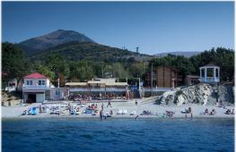
Pohnpei Island With its lush vegetation, jungle-covered mountain slopes and blooming hibiscus, it most closely matches the typical image of the southern island, although excess humidity spoils this picture somewhat. The main and most big Island in Micronesia, it has an area of 334 square meters. km. This is an almost rectangular island, framed by picturesque bays and narrow peninsulas. The island's coastline is formed mainly by tidal beaches and mangroves, but there are also many small islands with beautiful lagoon beaches between the island itself and the surrounding reefs.
The main city of the island is Colony, a relatively large settlement by island standards, still retains a colorful provincial character. small town Palikir, located just 8 km. nearby, is the capital of Micronesia. Pohnpei Airport and most of the island's hotels and restaurants are located in Kolonia.
Ancient stone city Nan Madol, lying on nearly 100 artificial islets off the southeast coast of Pohnpei, is Micronesia's finest archaeological site. Nan Madol was built from colossal basalt blocks during the period of a tyrannical dynasty Saudeler, which reached its peak in the 13th century. Nan Duvas- the largest part of the city still standing, external walls which reached 8 meters in height, and contained crypts on the inside. Although many of Nan Madol's temples, vaults, and reservoirs have been destroyed, the entire colossal, semi-legendary city still has great dramatic impact. The most famous natural monument of Pohnpei is the picturesque rock Sohes Rock(180 m), a basalt cliff that resembles a human face.
Chuuk Island (formerly Truk) very colorful, with a lively and quite “rough” coastline. Chuuk has 15 main islands, 92 outer islands and more than 80 lagoon islets. His biggest assets are sunken ships and planes from the Second World War. All over the world they know about "underwater museum" Chuuk- the entire Japanese fleet lies at the bottom of this lagoon, this is evidence of the greatest naval disaster in history. Each ship lies in the same form in which “death” found it - some are upright, some are completely intact, others are only partially preserved. Some of the transports were filled with weapons, trucks and fighter planes; team members also remained buried at sea.
The main activity in Veno, the main town on the island, - watching the sunrise over the island Faychuk in the western lagoon or the usual beach pastime. Most hotels are located in Veno, but there are also stylish local-style houses on other islands.
Yap Island- The land of giant stone money, the most traditional area in Micronesia. Yap consists of four islands - Yap, Tomil-Gagil, Map and Rumung. Unlike the other "high" islands in the country, which are volcanic in origin, Yap was formed by the uplift of a section of the Asian continental plate shelf. Hence the peculiar landscape of the island - large quantity hills and plains than mountains and valleys. Of the 134 outer islands, many are just tiny pieces of shore made of coral and sand, barely rising above the surface of the water. The island's communities are linked by old stone footpaths (some estimated to be centuries old), and village buildings are still constructed in the intricate traditional style of timber, thatch, rope and bamboo. It is a society with a strong caste system, where village elders and chiefs still have so much influence that they easily challenge the decisions of elected officials, and stone money is still used for some traditional transactions.
Please note that residents of Yap are very offended if a tourist points cameras at them ( taboo), although they are very friendly and receptive to travelers who respect their customs and culture. Most people have already adopted the Western style of clothing, but in everyday life, almost everyone, especially children, wear bright colored loincloths, and some of the women only wear woven skirts made from hibiscus leaf fibers. Almost every resident is constantly “busy” chewing betel.
Nukuoro Atoll- a real “shelter” for lovers of loneliness. One of Pohnpei's outer atolls, it contains 42 tiny islets that form an almost perfect circle around a lagoon 6 kilometers in diameter. The Polynesian people of the atoll are very welcoming, making it a great place to relax, or to spend some time just walking around the shore, searching for seashells and playing with the island's children. There is a small guesthouse right on the pier. There is no airport, and a passenger ship arrives only once a month.
Woleai Atoll, one of Yap's outer islands, is famous for its patriarchal simple lifestyle, friendly people and beautiful beaches. Its approximately 800 inhabitants live on just five of Woleai's 22 islets, some of which are clustered together and connected only by sandbars. Woleai "holds fast" to its traditional ways: canoes take precedence over motorboats and there are certain rules against wearing T-shirts, pants, baseball caps and other Western clothing. While foreign visitors are freed from any instructions and prohibitions, this helps to perceive the traditions and way of life of the islanders. Formally, there are no commercial hotels or guesthouses to stay at. long term, but it is usually easy to arrange an overnight stay for any period of time with local residents. Woleai is accessible by plane from Yap or by slow and circuitous boat from the capital. Permission is required to visit Woleai and the other outer islands of Yap: make a request to the Special Assistant for External Island Affairs in Colonia or Yap at least one month in advance of the visit.
etc.................