Nautical charts of the coast of Primorsky Krai. Favorites from Sputnik
Anna Bay is a bay in the eastern part of Peter the Great Bay, located between capes Gembachev and Gambetsky. The length of the bay is 1.7 km, width is 0.9 km. Anna Bay consists of a number of small bays and, due to its semi-enclosed water area, is well protected from high waves. Coastline The bays are varied - sections of sandy and pebble beaches are interspersed with steep cliffs. The hills surrounding the bay are covered with oak and bushes.
Astafieva Bay
Astafiev Bay is located on the territory of the Marine Reserve in the Khasansky district and is therefore sparsely populated. The water here is so clean that even from the nearest hill you can see the sandy bottom. The snow-white quartz sand of the beach shines in the sun, eclipsing the pristine beaches of tropical resorts. Astafieva Bay is protected from the wind by the high hills surrounding it.
Babkin Bay
Babkina Bay is a bay on west coast Russky Islands in Peter the Great Bay. First mapped (with some distortions) in 1959. It was explored in more detail and mapped in 1862 by the expedition of Lieutenant Colonel of the Corps of Naval Navigators V.M. Babkina. At the same time, the expedition named the bay after the name of the expedition leader V.M. Babkin, an outstanding researcher of the Sea of Japan.
Cormorant Bay
Baklan Bay is a large bay in Peter the Great Bay near the village of Slavyanka. The bay is located on the Bruce Peninsula between Cape Teal and the Clerk Peninsula. Opposite Baklan Bay are the Antipenko and Sibiryakova islands. The Poima River flows into approximately the middle part of the bay. In the central part of the bay there are sandy beaches with shallow depths. To the north, the coast is covered with forest and becomes more rocky and steep. South of the river The floodplain plants of the Primorsky Territory are represented by forbs and shrubs.
Boysman's Bay
Boysman's Bay is located on west bank Peter the Great Bay between capes Klerk and Krasny. The coast of Boysman Bay is one large beach, pebbly in some places and sandy in others. The sandy beaches are especially good in the northern half of the bay - from the mouth of the Ryazanovka River to Cape Klerka. Not far from it, in the northern part of the bay, is small island Clerk.
Valentine Bay
Valentin Bay is a unique corner of nature located in the Lazovsky district of Primorsky Krai. The bay was discovered on July 30, 1860 by an expedition led by V.M. Babkin, who was exploring the waters Far East on the schooner "Vostok". It is thanks to the date of the opening of the bay that it was named “Valentin”, in honor of the holy great martyr St. Valentine.
Wrangel Bay
Wrangel Bay is a bay in the eastern part of Nakhodka Bay, located between capes Petrovsky and Kamensky. The length of the bay is 3.5 km, the maximum width is 1.5 km. The bay was discovered in 1860 by the expedition of Vasily Babkin, who explored the coast of the Sea of Japan on the steam schooner Vostok. Named in honor of Bernhard Wrangel, a Russian navigator and hydrographer.
Gorshkov Bay
Gorshkov Bay, located south of Cape Lev, between capes Vysoky (in the south) and Sosnovy (in the north), is the last in a series of bays of the Far Eastern State Marine Reserve (Astafieva, Srednyaya, Gorshkova, Spaseniya, Nerpichya) in the vicinity of the Gamow Peninsula and Vityaz Bay.
Golden Horn Bay
Golden Horn Bay is a bay in Peter the Great Bay, on both banks of which the port city of Vladivostok is located. The bay is located on the northern shore of the Eastern Bosphorus Strait between capes Tigrovy and Goldobina. The bay is bordered from the northwest by the Shkota Peninsula.
Kalevala Bay
A very picturesque bay with a beautiful sandy beach. Even in the nicest weather summer days Kalevala Bay is almost deserted: it is difficult to get to and it is located in the protected area of the Far Eastern Marine Reserve.
Shallow Bay
Shallow Water Bay belongs to the Khasansky district of Primorsky Krai and is located south of the Peschany Peninsula - between Cape Ogranovich and the right slope of Mount Stolovaya. The bay is really shallow; with a silted and overgrown bottom; with low-lying banks overgrown with reeds and bushes. On the shore of the bay is the village of Beregovoe. A small river flows into the apex of the bay.
Muravyinaya Bay
Muravyinaya Bay is a bay in the Ussuri Bay of the Sea of Japan, located between Capes Turtlepakha and Obryvisty. Until 1974 it was called Maitoun. The shores of the bay, excluding the southwestern shore, are low, bordered sandy beaches. The Shkotovka and Artemovka rivers flow into the top of the bay.
Narva Bay
Narva Bay is located in the eastern part of the Amur Bay and is bounded in the north by Cape Turek on the Lomonosov Peninsula and Cape Brynner in the south, behind which is the small Heka Bay and then the vast Yankovsky Peninsula. A significant part of the coast of Narva Bay is composed of yellow sand. The Narva River flows into the bay.
Nerpichya Bay
Nerpichya Bay belongs to the Khasansky district and is one of five bays (Astafieva, Srednyaya, Gorshkova, Spaseniya, Nerpichya) that are part of the Far Eastern Marine Reserve in the vicinity of Vityaz Bay and the Gamow Peninsula.
Novgorodskaya Bay
Novgorodskaya Bay is located inside the bay of Posyet Bay and you can get to it by sea by passing Capes Astafiev and Shelekha. The entrance to the bay is located opposite the tip of the Nazimov Spit, between the bays of Reid Pallada and Expedition.
Pavlovsky Bay
Pavlovsky Bay is a bay in the eastern part of Strelok Bay in the Peter the Great Gulf. It received its name in 1892 in honor of the commander of the gunboat “Ermine”, Captain P.S. Pavlovsky. In Soviet times, Pavlovsky Bay was the main base for diesel and then nuclear submarines of the Pacific Fleet.
Patroclus Bay
Patroclus Bay is located on south coast of the Muravyov-Amursky Peninsula, going into northern part Bosphorus Strait - Eastern. Patroclus Bay is the easternmost of the bays on the southern coast of the Muravyov-Amursky Peninsula (Golden Horn, Diomede, Ulysses, Patroclus). The shores of the bay are high, rocky, steep, heavily overgrown with forest.
Raid Pallada Bay
Reid Pallada Bay, washing the Krabbe Peninsula, is home to many commercial fish: herring, saffron cod, flounder, greenling, smelt, etc. In the summer, along with the warm southern currents, mackerel, tuna, mackerel, and ivory come here. The migration routes of salmon are also located here: pink salmon, chum salmon, and masu salmon. The world of invertebrates is also extremely rich - sea cucumbers live here, sea urchins, scallops, squid, octopus, crabs, anadars, spizulas and shrimp. Clean sea water and prey fishing in Primorye - all this is Reid Pallada Bay.
Rifovaya Bay
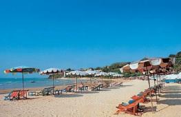
Rifovaya Bay is located between capes De Livron and Reefovy, near the village of Yuzhno-Morskaya and 40 km from Nakhodka. The bay has low shores bordered by extensive sandy beaches. The beaches of the bay extend for 2-3 km and are favorite place holiday at sea.
Salvation Bay
Salvation Bay is a small bay in the northeast of the Gamow Peninsula, adjacent to Astafieva Bay. The bay is limited by capes and has a pebble bottom. Opposite the bay there are small islands and a cordon of a marine reserve. The famous densely flowered pines grow on the rocky and steep shores of the capes bordering the bay.
Spokoinaya Bay
Spokoinaya Bay is a small bay in the Sea of Japan, located 30 km from Nakhodka towards the village. Oriental. The very name of the bay suggests that there are no winds and a warm sea with clear emerald water. In addition, Spokoinaya Bay attracts lovers of seaside holidays with its magnificent clean beaches of shallow white sand.
Srednyaya Bay
Srednyaya Bay is one of most beautiful places Southern Primorye, where the nature of the Primorsky region is presented in its full beauty. The bay is part of the Far Eastern Marine Reserve and one of its cordons is located here. On the shores of Srednyaya Bay there are mysterious and mysterious oak “Druid” forests, and the hard bottom of white sand blends perfectly with the blue water.
Sukhodol Bay
Sukhodol Bay (old name Kangauz) is a bay in the Ussuri Bay of the Sea of Japan. The bay is limited from the north by Cape Azaryev and from the south by Cape Krasny. In the east, the Sukhodol (old name Kangauz) and Petrovka rivers flow into the bay. The banks here are low and covered with grass. Northern and southern shores, on the contrary, are rocky and steep. The depths in the bay are shallow, with a silted bottom near the shore.
Primorsky Krai is a region located in the south of the Far East of the Russian Federation. A map of Primorsky Krai shows that the region borders Khabarovsk Territory, Sea of Japan, DPRK and PRC. The area of the region is 164,673 square meters. km.
Today Primorsky Krai is divided into 22 municipal district and 12 districts. The region includes 116 villages and 29 urban settlements. Largest cities region - Vladivostok ( administrative center), Ussuriysk, Nakhodka, Arsenyev and Artyom.
The region has a well-developed mining industry. Brown coal, non-ferrous metals, oil, gas, gold, boron, etc. are mined in the Primorsky Territory. Large sectors of the economy are the forestry and fishing industries.
Historical reference
The territory of modern Primorsky Krai belonged to the Bohai state. The fall of the Jurchens occurred in the 13th century due to attacks by the Mongol-Tatars. Later, the lands went to the Jin Empire, and after the Treaty of Beijing they began to belong to the Russian Empire.
In the 19th century, the Russians began to explore the Far East. The Primorsky region was created, which in 1920 was transformed into the Far Eastern Republic, and then into the Far Eastern Territory. In 1938, Primorsky Krai was created.

Must Visit
On detailed map In the Primorsky Territory you can see various natural attractions from a satellite: the Brother and Sister hills, the Far Eastern Marine Reserve, the Sikhote-Alin and Ussuri reserves, the Borisov Plateau and Vasilkovsky nature reserves, National parks"The Udege Legend" and "Call of the Tiger".
Among the natural attractions, it is worth noting the numerous bays, waterfalls, mountains, caves, capes and islands of the Primorsky Territory.
Satellite map of Primorsky Krai
Map of Primorsky Krai from satellite. You can view the satellite map of Primorsky Krai in the following modes: map of Primorsky Krai with names of objects, satellite map Primorsky Krai, geographical map of Primorsky Krai.Primorsky Krai is located in the southernmost Far Eastern part of Russia on the coast of the Sea of Japan. The regional center is the city of Vladivostok.
The climate of the region is moderate monsoon. On weather in the Primorsky Territory, cyclones coming from Pacific Ocean. In winter they bring cold air, creating windy but sunny weather; and in the summer there are strong destructive typhoons. Therefore, in general, the weather in the Primorsky Territory is windy and humid.
On the territory of the Primorsky Territory you can still see the ruins of fortifications and sites, which are reminiscent of that distant time in the Middle Ages, when the Primorsky Territory was part of the Bohai state. The largest settlements are Nikolaevskoye and Shaiginskoye. Many historical and architectural monuments can be seen near the city of Arsenyev. That's over 40 archaeological sites, which include caves, settlements, ancient settlements. www.site
One of the main attractions Primorsky Krai– Vladivostok fortress. This fortress is the only surviving sea fortress in Russia. Today, the defensive structures of the fortress are museum complexes and one of the most popular places visits by tourists.
Thanks to the diverse nature and landscapes, relaxing tourism is harmoniously combined with sports and extreme tourism. Lovers active species Sports people will have a great time doing diving, parachuting, surfing, caving, etc.
Those who prefer a relaxing holiday in nature should give preference to eco-tourism. Numerous travel agencies offer not only holidays in sanatoriums and boarding houses, but also various tourist routes, running through the most picturesque areas of the Primorsky Territory. Also popular in
Primorsky Krai is located in the south of the Far East. This region is located on the border with China and North Korea. Use a satellite map of Primorsky Krai to view its location, settlements, roads and other objects. Move around the area by zooming in and find out where the main train stations and airports are in the region.
The northern part of Primorye borders on the Khabarovsk Territory. These 2 regions are connected by road, rail and by air. And in the south and east, as can be seen on the map of the Primorsky Territory with diagrams, its territory is washed by the Sea of Japan. The coastal zone is dotted big amount small bays, including:
- Ussuri;
- East;
- Shooter;
- Posyet;
- Amursky.
The coastal area is mountainous. The cities and towns that the map of Primorsky Krai with districts displays are located in the lowlands. Primorye includes several large islands:
- Popov;
- Russian;
- Askold;
- Reinecke;
- Putyatina.
Of the water bodies, the largest ones can be especially highlighted - Lake Khanka and the Ussuri River. On the banks of these reservoirs there are many tourist centers, fishing and hunting are carried out.
Districts on the map of Primorsky Krai
Primorye is divided into 22 districts, 4 of which are included in the Far North zone:
- Terneysky;
- Dalnegorsky;
- Olginsky;
- Kavalerovsky.
These areas on the map of Primorsky Krai are characterized by the least developed infrastructure, a small number of settlements and difficult living conditions. There are almost no economic facilities or industrial enterprises here, and trade is poorly developed.
There are numerous hunting grounds in the region. In Chuguevskaya and Terneysky there is hunting for wapiti and elk, and in Lazovsky and Pozharsky there are wild boars and bears. On a detailed map of Primorsky Krai you can find suitable places for active rest, hunting and ecotourism. Also in the region is Lake Elma with a large reserve mineral springs and healing mud.
The largest districts in Primorye:
- Spassky;
- Krasnoarmeysky;
- Terneysky.
The railway runs along the western border of the region. From here the Trans-Siberian railway runs to Moscow. In the northern regions transport connection poorly developed. A detailed road map of the Primorsky Territory shows that the main highways pass through the southern and western regions.
Located near Vladivostok international Airport"Knevichi". There are also several in the region largest ports, whose main activities are related to fishing and container cargo transportation.
Map of Primorsky Krai with cities and villages
There are 29 cities and 116 villages in Primorye. Most significant city region - Vladivostok. It is a large industrial, port and economic center of the region. The population of the regional capital is more than 600 thousand people. If you use a map of the Primorsky Territory with settlements, then on it you can find all the objects of Vladivostok, look at its streets, find train stations and the airport.
The second most important city is Ussuriysk. The largest cities of the region are connected highway A-184. North of Ussuriysk on the border with China is the main attraction of Primorye - Lake Khanka. This is the purest fresh lake, which contains a huge number of fish. There are several small settlements located here, which can be seen on a map of the Primorsky Territory with villages:
- Mayskoe;
- Novonikolaevka;
- Trinity;
- Astrakhan.
In these villages there are main recreation and fishing centers. Fishing here is carried out all year round.
Another “calling card” of the region is the 6-lane road bridge across the bay, which connects the districts of Vladivostok, and its length is almost 1.5 km. You can find the bridge on a map of Primorsky Krai with cities and villages. In the evening, tourists and city residents love to stroll along it. Numerous lights and bright illumination make it a very romantic place.
Economy and industry of Primorsky Krai
Thanks to natural resources, location on the border of neighboring developed countries, as well as a large number plants and factories Primorye is a large industrial region. The regional economy is represented by such industries as:
- metallurgy;
- mechanical engineering;
- mining;
- energy;
- tourism;
- international trade.
Millions of tons of cargo are shipped annually from the ports of the region, which can be found on Yandex maps of the Primorsky Territory. Fishing makes a significant contribution to the economy of Primorye. Enterprises in the region also produce spare parts for cars, food, electricity and heat. Gold, diamonds and other rare minerals are mined in the region.
Tourism is of great importance for the region. Primorye has the largest reserves and hunting grounds. Tourists are offered river rafting, visiting natural and archaeological monuments, and hunting wild animals and waterfowl. Big cities Those arriving in the region are greeted with modern, comfortable hotels. Also in small populated areas There are recreation centers for those who love active tourism.
Map of Primorsky Krai from satellite. Explore the satellite map of Primorsky Krai online in real time. A detailed map of Primorsky Krai was created based on satellite images high resolution. As close as possible, the satellite map of Primorsky Krai allows you to study the streets in detail, separate houses and sights of the Primorsky Territory. The map of Primorsky Krai from a satellite can easily be switched to regular map mode (diagram).
Primorsky Krai is located in the southernmost Far Eastern part of Russia on the coast of the Sea of Japan. The regional center is the city of Vladivostok.
The climate of the region is moderate monsoon. Weather conditions in the Primorsky Territory are greatly influenced by cyclones coming from the Pacific Ocean. In winter they bring cold air, creating windy but sunny weather; and in the summer there are strong destructive typhoons. Therefore, in general, the weather in the Primorsky Territory is windy and humid.
On the territory of the Primorsky Territory you can still see the ruins of fortifications and sites, which are reminiscent of that distant time in the Middle Ages, when the Primorsky Territory was part of the Bohai state. The largest settlements are Nikolaevskoye and Shaiginskoye. Many historical and architectural monuments can be seen near the city of Arsenyev. These are more than 40 archaeological sites, which include caves, settlements, and ancient settlements.
One of the main attractions Primorsky Krai– Vladivostok fortress. This fortress is the only surviving sea fortress in Russia. Today, the fortifications of the fortress are museum complexes and one of the most popular tourist destinations.
Thanks to the diverse nature and landscapes, relaxing tourism is harmoniously combined with sports and extreme tourism. Fans of active sports will have a great time doing diving, parachuting, surfing, caving, etc.
Those who prefer a relaxing holiday in nature should give preference to eco-tourism. Numerous travel agencies offer not only holidays in sanatoriums and boarding houses, but also various tourist routes that run through the most picturesque areas of the Primorsky Territory. Also popular in Primorsky Krai sport hunting and fishing.