The Lost World of Ayan. Hiking route, mileage, numbers
23 days, 480 km, Duluk, northern lakes, packraft rafting, Red Book white-tailed eagle and Putorana bighorn sheep.
Below is a long post with lots of pictures.
General idea of the hike and material
This was the fifth visit to the Putorana Plateau, a walk-water format. The first walking visit took place in the summer of 2013 with a group (http://www.marshruty.ru/travel/putorana2013/). The second solo walking visit was in the summer of 2015 - http://a-podkorytov.livejournal.com/2790.html (22 days, 269 km). The third solo walking and water visit was in the summer of 2016 - http://a-podkorytov.livejournal.com/4194.html (30 days, 580 km). The fourth single ski visit was in April 2017 - http://a-podkorytov.livejournal.com/5286.html (14 days, 175 km). In the summer of 2017, there were some difficulties in route planning due to the reconstruction of the airport in Norilsk. As a result, on the plateau we managed to slightly look at Lake Duluk, the northwestern lakes (Negu-Iken, Nyoralah, Bogatyr), highest point western part of the plateau (Bogatyr town) and raft like a big one along the Mikchangda river.
Below is more of a photo report than a story. Most of the technical issues, security and communications issues on the route were resolved in the same way as before (described in detail in previous materials, I do not repeat myself). Only those details are mentioned that were not there before and which may be useful.
The upper reaches of the river Mikchangda and the city of Orlinaya. Putorana Plateau. July 2017.
Hiking route, mileage, numbers
The final detailed thread turned out like this: Norilsk - Northern part lake Ayan - r. Big Khonna-Makit - the northern part of Lake Ayan - 100 in the upper reaches of the Duluk River - the right bank of the Duluk River - Lake Duluk - the vicinity of Lake Duluk - the left bank of the Duluk River - the northern part of Lake Ayan - the Ayan River (rafting from the source to the left large tributary east of Lake Negu-Iken) - Lake Negu-Iken - River Dulugu-Iken - Lake Nyoralah - Lake Bogatyr - v. Bogatyr (1591m) - River Yuzh.Nerakachi - upper reaches of the river. Mikchangda - a pass in the upper reaches of the Bucharama river - the Mikchangda river (rafting from Orlinaya to Lama lake) - Lama lake - Norilsk.
The first half of the route (R.Duluk and surroundings of Lake Duluk) was devoted to work for the benefit of the protected system. The second half of the route is an independent exit to Lama Lake through the northern lakes and the Mikchangdu River. The mileage of the active part was 480 km (on the track of the navigator, without coefficients), of which the walking part was 306 km, the water part was 174 km (53 km of the Ayan river, 121 km of the Mikchangda river). I spent 23 days on the route (12.07-03.08). The map-scheme shows the route traveled, the numbers of overnight stays correspond to the days of the route.
Map-scheme of the route. Putorana Plateau. July-August 2017.
The black color shows the hiking section of the route in the interests of the Putoransky Reserve, the blue color shows the rafting section on the packraft, the red color shows the hiking section of the route.
The food layout was moderate, 400 grams per day. For the first time in a summer campaign I used lard. Working. For food, there were helpers at the cordon of the reserve, as well as several graylings on the Ayan and Mikchangda rivers. The grayling of this year on the Ayan River and the Mikchangda River seemed to be larger on average than on the Delochi River and the Kutaramakan River in 2016, but with strong-willed qualities he is still in full order.
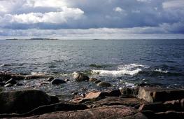
Lake Ayan and the spill of the Ayan River. Putorana Plateau. July 2017.
Lake Dog, the mouth of the river Horonen. Putorana Plateau. July 2017.
Thread of the route: river and lake Duluk
The first evening I ran radially to see the waterfalls on the Bolshoy Khonna-Makit river. The river Chopko 2nd fermented 200-300 meters above Bolshoy Khonna-Makita.
Upper waterfall on the river Bol. Khonna-Makit. Putorana Plateau. July 2017.
Lower waterfall on the river Bol. Khonna-Makit. Putorana Plateau. July 2017.
Then there was an ascent to the plateau and a descent to the beginning of the canyon of the Duluk river. I briefly looked at a 100-meter waterfall on a tributary in the upper reaches of the Duluk River. Mid-July - so-so time on the plateau. On a sunny day, from 7 am, the heat can already begin.
Vdp.100m on a tributary in the upper reaches of the Duluk river. Putorana Plateau. July 2017.
I walked around Lake Duluk. Okay. Quite far from tourist hiking and even rafting routes. Buzzard was a little disturbed.
Buzzard. Putorana Plateau. July 2017.
Duluk Lake and Duluk River. Putorana Plateau. July 2017.
With Putorana snow sheep - everything is according to the April agreement. This time he was friends with a seasoned male. An older retired ram with a broken horn was caught sleeping at midnight and escorted for several hours until a direct morning acquaintance.
Putoransky snow sheep. Putorana Plateau. July 2017.
Protecting the sensitive sleep of the ram, he sat for 4.5-5 hours. As usual, the ram kimarit, shakes his head, periodically drives away the midges. Around 05 am, it's time to go get acquainted. Everything was already conducive to approaching and hugging in a friendly way, but during the sitting he got cold, everything was numb, he slightly stumbled on the slope, which made him lose confidence. They limited themselves to simply waving to each other and wishing them a good day.
Putoransky bighorn sheep on the background of Lake Duluk. Putorana Plateau. July 2017.
Putoransky snow sheep. Putorana Plateau. July 2017.
Putoransky snow sheep. Putorana Plateau. July 2017.
Putoransky snow sheep. Putorana Plateau. July 2017.
Putoransky snow sheep. Putorana Plateau. July 2017.
In addition to the aksakal, there was a female on Duluk, apparently with a lamb nearby, because disappeared quickly and without a trace.
The inspectors of the Putoransky Reserve are so cool that they recognize a sheep from a photograph and correctly indicate the place of its shooting.
Lake Duluk. Putorana Plateau. July 2017.
Waterfall on a tributary of the Duluk River. Putorana Plateau. July 2017.
Rafting on the river. Ayan
For a change, after the drought of 2013 and 2016, in the summer season of 2017, we managed to see high water on the plateau associated with late floods and rains. The section of the river from the source to the confluence of the Kaltama River, according to the descriptions, is the simplest and middle water should not be difficult. As it turned out later from communication with colleagues in the workshop, water was not everywhere. In the eastern part of the plateau, water was not poured into the rivers (R. Khigdekit).
Almost immediately after sailing along Ayan, it began to rain, in the rain, without stopping, he swam briskly for 3 hours, walked about 20 km. Came across dumb shivers with stones, some managed to get past the edge.
Ayan river. Putorana Plateau. July 2017.
Ayan river. Putorana Plateau. July 2017.
Around 22-00 on the left bank I was surprised to see a camp and two trimarans. The team from Norilsk, local men, were also surprised by the meeting and the raised water. We talked sincerely, exchanged impressions and plans.
Rafting team on trimarans from Norilsk. Meeting on the bank of the Ayan river. Photo from the copter of Mikhail Karpov. Putorana Plateau. July 2017.
They received us very hospitably, fed us well, gave us baked fish. We were invited to a camping bath. It is difficult to refuse, but the schedule did not allow. Mikhail Karpov escorted us to the nearest shiver with a quadrocopter. Somehow sailed away from their parking lot (MPEG4 Video 1920x1080):
The author of the video materials is Mikhail Karpov (Norilsk). Andrey Podkorytov, the boat passenger and the author of the undercut. Ayan river. Putorana Plateau. July 2017.
Ayan river. Putorana Plateau. July 2017. Photo by Mikhail Karpov.
I wanted to go through the left large tributary in order to spend the night closer to the mouth of the Kaltama river. Approximately 3 km before the left tributary, difficult shivers with large shafts began. Since it rained almost all day, there was quite a lot of water. In my experience, it was not reliable on packraft. Further there should have been more water, the river collected tributaries. It was possible to wait for the water to fall or to get out of the Ayan canyon on the plateau impromptu. I decided to shorten the rafting section by 15 km and climb onto a plateau in an unplanned place. Before the tributary, he swam a little, spent a few shivers along the shore. Around 03:00 went ashore. For the whole day I passed 49 km by rafting, wet, cool, tired. Usually, the main argument against irritation, fatigue, cold and hunger was a full pot (Jetboil 0.8l) of Ivan-tea with the addition of super-herbs. The next day there was no rain and the water fell, but the decision to leave the water had already been made. After Ayan, a revision of the products was carried out, during which, unable to resist, under the pretext of a hard rafting day and the 50 km traveled, he looted a little in his stocks.
Ayan river. Putorana Plateau. July 2017.
From the river rise to the plateau next to the tributary almost head-on along the packed deer paths. At one fine moment, when setting up the 13th camp, the tent was blown away by the wind. Catch up with her so-so, but necessary. Repulsed half-sitting, propping up the wall, a dangerous heavy wind.
Thread of the route: lakes Negu-Iken, Nyeralakh, Bogatyr
We had an evening dinner by Lake Negu-Iken. Then he walked along the coast. beautiful curves coastline, fog, deer antlers left over from the natives to graze. Lake Negu-Iken is not easy and very correct.
Lake Negu-Iken. Putorana Plateau. July 2017.
fall. Lake Negu-Iken. Putorana Plateau. July 2017.
A bear with two cubs was walking on the slopes near Lake Nyeralakh. In the valley of the lake, bones of deer eaten by wolves are found everywhere.
Lake Nyeralakh. Putorana Plateau. July 2017.
A night radial trip was organized to the top of Bogatyr. At 23-15 we had lunch in the saddle (overnight 16 on the map). After sunrise I went to the highest point. He returned to the backpack at 07-35, fought back at 8-10. During the day I was in no hurry, rest for the night radial. Night Radials are a proven evil, but the only way to be in good location at the right time, if necessary. Lake Bogatyr is not easy and wrong.
Lake Bogatyr. Putorana Plateau. July 2017.
Lake Bogatyr, view from the top of Bogatyr. Putorana Plateau. July 2017.
Lake Bogatyr and the top of the Bogatyr massif. Putorana Plateau. July 2017.
Promotional frame for a friendly firm. The top of Bogatyr. Putorana Plateau. July 2017.
We managed to cross the Yuzh.Nerakachi River on stones, in other places it was deep. Near the lakes in the upper reaches of the Mikchangda river, deer bones lie all over, every 100-200 meters, on every elevation. Apparently favorite place wolf hunting.
River Yuzh.Nerakachi. Putorana Plateau. July 2017.
The upper reaches of the Mikchangda river, the city of Orlinaya. Putorana Plateau. July 2017.
Instead of a typical descent to the Mikchangda river by the shortest route (through the pass from the Bucharama river), I saw a more gentle descent four kilometers to the northwest. Good.
Rafting down the river Mikchangda
At 17-40 I went to the equipped parking lot near Mikchangda. Slowly had lunch, shifted, sailed at 22-00. There are many rifts in the upper reaches, packraft in some places had to be carried out with your feet.
The upper reaches of the Mikchangda river. Putorana Plateau. July 2017.
After forest lake on the right bank of the Mikchangda, in front of the mouth of the Mikchangda-Ondodomi river, stretches begin almost without a current, periodically replaced by rifts or floods of the river into several fast channels. Often jets are carried to fallen trees. Many stretches almost to the very mouth of the Talikit river. In areas of stretches in a strong headwind, at times we had to hold on tightly to the bushes on the shore so as not to swim in the opposite direction.
The Mikchangda River, the area of the tributary of the Mikchangda-Ondodomi River. Putorana Plateau. July 2017.
Mikchanda river. Putorana Plateau. August 2017.
After 1-2 km after the mouth of the Talikit river, long rifts begin, gradually turning into shivers. The river is changing, there are a lot of stones in the channel, it is inconvenient. Shivers are 100-200-300 m long, the bottom is coarse, packraft catches. The current is everywhere, it swims quickly, there are no stretches. Shivers are often taken out to trees in the water. Picked up a few pieces. There are many channels on the spills, sometimes you need to packraft with your feet (the most full-flowing channel is not obvious). After the right tributary of the Yuzh.Abagalakh river, the character of the Mikchangda river changes again, again long stretches, between them full-flowing rifts with small pebbles. The shivers are rarer and calmer;
Mikchanda river. Putorana Plateau. August 2017.
Mikchanda river. Putorana Plateau. August 2017.
When approaching the right tributary of the Yuzh.Iken river, there are more and more reaches, there is no current at all. I didn't even notice the flow. The river is getting fatter and faster. The long shivers begin. First, light, then more and more full-flowing, longer and more serious. Since the water was above average and the river absorbed tributaries, I considered the option of leaving the river from the confluence of the Yuzh. I got carried away, Iken did not notice the tributary of the South, it turned out to swim further. On the section of the river after the confluence of the South Iken River and up to the Mikchangda delta, there are several of the most full-flowing and serious shivers. Something was escorted by the shore, something was floating by the edge. In the delta, Mikchangda begins to flood, there is no current, it is shallow, it is necessary to choose channels so as not to run aground, the fairway is not obvious. In some places, the depth is 10-15 centimeters. Directly to Lamu it is better to sail along the coast, in other places it is shallow.
An unpleasant moment for packcraft are hanging / fallen trees, because. they threaten not just with a coup, but with an accident with damage to the boat. This bottleneck, because packraft is still a compromise between weight and reliability. From the source to the Kaltama River, the Ayan River is wide, with pebbly banks, without twisted turns. I don't remember any problems with trees on Ayan at all. It's different on Mikchangd. In places of flooding, the river has a bunch of narrow winding channels with a good current and a large number of fallen trees, often the jet takes them right on them. There are also a lot of trees in the water in the stretch areas, often they are completely hidden under water, you need to look carefully.
The Red Book inhabitants of the plateau were noted not only by rams, but also by birds in the face of the white-tailed eagle.
White-tailed eagle. Putorana Plateau. August 2017.
White-tailed eagle, chick. Putorana Plateau. August 2017.
Arctic terns attack not only people, they even chase white-tailed eagles in the tail and mane, on the side of which there is a numerical advantage.
Arctic tern and white-tailed eagles. Putorana Plateau. August 2017.
Somehow I finished on the Lama:
Lake Lama. Putorana Plateau. August 2017. Photo by Ilya Kalinsky.
A group of tourists, familiar in absentia by correspondence, met with the words “Small world”. The guys cooked a delicious fish soup, it turned out a wonderful evening. The next morning unhurried packing and drop off to Norilsk. Ilya Kalinsky helped with the launch by boat from the mouth of the Mikchangda River to Lake Lama to Norilsk. I recommend - fast, convenient, reasonable prices.
The shore of Lama Lake, the night before the release. Putorana Plateau. August 2017.
Notes for the violent
There is no ropeless descent to Duluk Lake along the couloir opposite the prominent peninsula in the northern part of the lake.
At high water, even the calmest section of the Ayan River according to the descriptions (from the source to the confluence of the left tributary of the Kaltama River) can offer shivers that are not obvious for packcraft in the expedition format. My main shivers were at the confluence of the Bol. Khonna-Makit river, at the confluence of the Khonna-Makit and Munil rivers, and also 3 km before the left large tributary.
The section of Mikchangda below the confluence of the South Iken and up to the delta with water above the average is rather severe. The river is wide, full-flowing, there are many long shivers (up to 200 meters) with a large number of floodings and protruding stones in the channel, standing shafts from 0.5 to 1 meter. A few shivers - well, not at all for a loaded packraft. Without insurance, viewing and willingness to swim, it’s probably not worth going directly on a loaded packraft. Something can be passed by the edge, something can be held by the shore. Although competent watermen said that skillfully everything described is passed on packraft without problems. The key word is skillful.
Raster maps of the General Staff in a satellite navigator are most convenient for typical routes, when everything is approximately clear and there are descriptions. To be able to plan and change the route on the go, impromptu, or for new routes that have not been traveled, it is much more convenient to use GHZ raster maps (scales up to 500m, even 250m for fans). The distributing site hangs periodically, it is useful to pump out the necessary cards in advance.
This year, in addition to the typical ones, the most serious non-trivial hikes were made on the Putorana Plateau: strongly hiking (630 km, https://www.marshruty.ru/travel/platoputorana/, https://www.youtube.com/watch?v=WQvs3JpjqT4&feature= youtu.be), strongly water walking-water (675 km, http://photopoxod.ru/putorana2017) and strong water (800 km, https://vk.com/volkovmix?w=wall52949044_1058%2Fall).
Duluk River. Putorana Plateau. July 2017.
Total
It didn’t work out to be a very cheerful thread, but we managed to see something.
Duluc Lake area. Putorana Plateau. July 2017.
A few (many) more photos https://a-podkorytov.livejournal.com/6500.html
One of the most interesting components of the local landscape. There are more than 22 thousand lakes here, and they occupy about 10% of the plateau area. Nowhere in the world in a limited area is there such a number of long (50–150 km) and deep (50–420 m) lakes as on the Putorana Plateau.
The largest Putorana lakes arose in large basalt cracks, which are very similar to fjords. northern Norway, but not on the coast, but in the middle of the land. The total volume of water in the Putorana lakes is the second largest surface reservoir fresh water in Russia after Baikal. The largest lakes(Lama, Omuk-Kyuel, Yt-Kyuel, Keta, Khantai, Kutaramakan) cut into the plateau from the west.
The second place in terms of depth is occupied by lakes preserved in the old channels of large rivers that left their valleys during the restructuring of the hydroelectric network. A huge number of small and medium-sized lakes by local standards are occupied by oxbow, thermokarst baths and depressions in basalt.
Local lakes have almost the same composition of the main crystalline rocks, which makes it easier to identify the climatic and chemical-biological components of the landscape. All lakes on the plateau are flowing, that is, with a relatively fast water exchange. This is one of the reasons for the low mineralization of water - from 13 to 42 mg / l - which is very close to ordinary rainwater, both in purity and in taste. For comparison, Baikal water has a mineralization of 93 to 150 mg/l. When I was on the Putorana Plateau in July-August 2015, even the hardened participants of our trip often froze because of the very “soft” water. The fact is that soap in such water is washed off the body longer, so it took a lot of effort. And the water was also cold, especially in the summit lakes - about 5°C!
It would seem that in constant cold water, as in Baikal, oxygen saturates the entire water column (oxygen content does not fall below 8 mg/l even in winter), but due to scarce aquatic vegetation and slow soil-forming process, the content of biogenic elements in lake waters is extremely low, which hinders the development of life in lakes.
The aesthetic significance of the territory of the plateau for sophisticated travelers is given by numerous waterfalls, which differ both in shape and in the power of the stream. Their scale and quantity are impressive (the Putorana Plateau has the highest concentration of waterfalls in Russia and, possibly, in the world). Here, on the Kanda River, there is one of the highest waterfalls in Russia - 108 meters high.
Perhaps, in no other region of Russia is there such a contradictory built hydrographic network as in the Putorana Mountains. It combines typical mountain streams with numerous rapids and waterfalls and deep basins occupied by flowing lakes and thick deposits. In some parts of the plateau, the rivers are typically flat with a bottom covered with silt - where the water did not have time to cut through the rapidly rising surface. The channels of many rivers are dotted with canyons.
Combinations of signs of both a mountainous and a flat river are clearly visible in the example of the intricately curving Kureika. Its history is closely connected with the ancient river that existed on the Putorana before the rise of the territory and crossed almost the entire middle, currently the highest, part of the plateau. The source of the river was north of Lake Ayan, and its course passed southeast through the modern middle part of the Kureika valley into the Lower Tunguska basin. Tectonic movements, which redistributed the flow of the ancient river about 10 thousand years ago, caused the emergence of two beautiful fissure lakes: Ayan (55 km long, maximum depth 256 m) and Anama (54 km long, maximum depth 120 m). Residual lakes remained in the former channel of Kureika: Monomakli, Omutachi, Yadun. Along the southwestern part of the plateau, another ancient and later also rebuilt river valley, the Vivi-Agatskaya, was revealed.
Due to active tectonic movements, all fissure lakes of the plateau deepened. Almost perpendicular to their former directions, new deep cracks, therefore, the lakes on Putorana have angular outlines - with the exception of large lakes in the western part, which have bends only in their eastern extremities, which are located directly in the mountains. At the bottom of Lake Agata, larches were found standing on the vine - witnesses of the modern deepening of the lake.
Photo © Dmitry Zamorin from westsib.ru.
See also about the geography and geology of the Putorana Plateau:
Stepped plateau Putorana, "Elements", 09/27/2016.
Fedor Shabalin
The administrative center of the Ayano-Maysky district and the rural settlement "Selo Ayan". This term has other meanings, Ayan is a polysemantic term: Ayan Male name Ayan is a river in Russia, a tributary of the Kheta River. Ayan Bay in the Sea of Okhotsk. Ayan is a settlement in Russia, Bauntovsky Evenki district of Buryatia.
Ayan is a lake beyond the Arctic Circle, in the Krasnoyarsk Territory, in the center of the Putorana Plateau, in the northwestern part of the Central Siberian Plateau, in the basin of the river. Khatanga.
The catchment area, according to the State Water Register, is 1869 km2. In the north, the river flows out of the lake. Ayan, the left component of the river. Khety, a tributary of the river. Khatanga.
The lake of glacial-tectonic origin is located in a narrow tectonic basin.
The water's edge is located at an altitude of about 470 m above sea level. The area of the water mirror, according to the data of the State Water Register, is 89.6 km2, the length of the lake is about 60 km, the maximum width is 3.2 km, the depth is up to 250 m. area of the water table.
The lake stretches in a long narrow strip among the mountains from the north - northwest to the south - southeast, forming two long bays in the southern part - the so-called "trousers", as they are called locals. The banks are predominantly steep, steep, in some places they rise above the water surface to a height of more than 1 km. In the northern part of the lake, at the source of the river. Ayan formed a wide valley. Trapp relief is developed in the region - a complex of high flat-topped massifs separated by deep and wide stepped canyons. The catchment area is located on the border of the northern sparse taiga and forest tundra.
The lake is flowing, with clean clear water low mineralization, with a favorable oxygen regime; the content of biogenic elements is low. It is characterized as oligotrophic. The lake is little explored.
The lake is fed by snow and rain. The spring rise in levels begins even during freeze-up, the maximum values occur at the end of July - beginning of August. Usually the lake is covered with ice for about ten months, it is freed from ice very late - sometimes even in August ice floes float on its surface.
The valley of the lake and the river Ayan is one of the highways of the spring course reindeer to the north.
In the interfluve of the Ayan and Holokhit rivers, including Lake. Ayan, Putoransky was formed in 1988 nature reserve of federal importance with an area of 1887 thousand hectares, the main objects of research and protection of which are the Putoran subspecies of the bighorn sheep, the Arctic goose, the white-tailed eagle and the gyrfalcon, which are listed in the Red Book of Russia. In 2010, the Putorana Plateau was included in the list of objects of the World Cultural and natural heritage UNESCO.
permanent settlements not on the lake. In the Kapchug Bay, at the southern end of the lake, there is a cordon of the Putoransky Reserve.
The seasonal part of the work at the Northern Ayan cordon has been completed. For about three months, our colleague Ivan Kobilyakov participated in the expedition, and now, having returned, he shared with us his impressions and some results of his work. The main work of the cordon continues, and in the meantime, we will learn about it from a direct participant.
Working at the cordon of the Federal State Budgetary Institution "Reserves of Taimyr" from afar looks very romantic. Beautiful landscapes, rare animals and birds, harmony with nature ... This is how it really is. But at the same time, in order to achieve the set goals and objectives, one cannot relax even for a minute.
Together with the inspector of our organization, Vasily Sarana, we flew to the Northern Ayan cordon (the central part of the Putorana Plateau) on April 24th. I returned back on July 12, having spent a total of 80 days on Ayan. Vasily remained at the cordon at least until autumn. Now his partner will be an employee of the environmental education department Timofey Volkov.

Thanks to the measured rhythm and regularity of our studies, quite a lot was accomplished during the spring-summer stage of the expedition. First of all, we were engaged in research on the spring migration of wild reindeer. From the first day, our small detachment conducted regular routes in the vicinity of the cordon, set up camera traps, recorded traces that appeared in the snow. Further processing of the information will make it possible to give a more accurate estimate of the number of deer, but it is already clear now: compared to previous years, there are much fewer of them in the Ayan Valley.

Deer - the basis of the life of the nature of the Putorana Plateau. Predatory animals that live in the valley of Lake Ayan were waiting for the migration of deer no less than ours. What is a source of statistics for scientists, for wolves, bears and wolverines is a long-awaited food after severe winter frosts and polar nights. We were lucky to capture a very interesting shot with a camera trap. A bear recently woken up from hibernation, shaking its shaggy sides, is trying to catch up with the herd. Deer rush about. The bear makes a dash to catch up with at least one. But - failure! Deer easily hide from the chase. The bear walks back and forth puzzled, as if thinking about when there will be another opportunity to sneak up on prey so close and will he be lucky next time? “Oh, chew the roots again!” - the omnivorous bear is probably thinking, at the exit from the field of view of the camera trap ...

Wolves and wolverines, due to a decrease in the number of deer, have an even harder time - they are poorly adapted for roots. The wolverine caught in the frame looks completely thin. But its Latin name Gulo gulo means "glutton" in translation.
Only birds really pleased us with their abundance. We watched with pleasure how our permanent neighbors, white-tailed eagles, fished at the source of the Ayan River in the second half of May, and then, after loud mating games, flew down the valley and sat on the nest. In the 20th of May, geese and began to appear. Bean goose flew over the cordon first. Right behind them - mergansers, pintails, wigeons and other representatives of noisy waterfowl. They landed on the open water in large flocks and staged demonstration maneuvers right in front of the cordon. Sandpipers and snow buntings completed the picture of spring. Along the river bank they tirelessly collected mayflies right from the ice, paying no attention to us.

Although there were several timid thaws at the beginning of May, the spring of 2017 turned out to be stormy and impetuous. Vasily Sarana, who spent the last five springs on Ayan, says that he has never seen such a high flood as this year in these parts. The maximum water level occurred on May 16-17. These days, the river overflowed its banks and flooded not only the floodplain, but also the lowering of the first terrace above the floodplain. After several sunny days, heavy rains began, which quickly melted the rest of the snow.

Summer season really began when larch needles opened up and the first flowers began to appear. The forest was filled with the singing of birds and somehow immediately emptied. The reindeer migration has come to an end. Predators have also become less likely to fall into camera traps.
My part of the expedition to Ayan Lake is over. Ahead - processing the collected materials and writing a report. Vasily Sarana still remains at the cordon. Now his partner is an employee of the environmental education department Timofey Volkov. We wish good luck to the workers of the cordon "Northern Ayan" and the inviolability of the beauties of its surroundings!
Lake Ayan is located in the Taimyr Dolgano-Nenetsky District, in the very center of the Putorana plateau, composed of ancient basalts. The length of the reservoir is 58 kilometers, its northern and central parts have a north-north-west - south-south-east direction. Then the reservoir changes direction several times, following the contours of the fault, its southern part is oriented strictly from north to south. The width of the lake is not constant, in the northern part it is narrower (about one kilometer), in the southern part the width of the reservoir reaches two and a half kilometers. Here the lake is divided into two deep bays. The length of each bay is about 10 kilometers, the average width is about 800 meters. One of the bays stretches from north to south, the other - from east to west. The bays are located almost perpendicular to each other. A river of the same name flows out of the lake - Ayan.
The water in the lake is clean, very weakly mineralized, from a boat the reservoir is visible at a depth of almost twenty meters. The shores are gently sloping in places, steep in places, sheer cliffs go straight to the water.
Lake Ayan surround high mountains with steep slopes and flat, leveled peaks. The tops of the mountains are either completely devoid of vegetation, or covered with rare shrubs, lichens grow on the stones, and northern mosses grow in the depressions between the rocks. There is no vegetation on the steepest mountain slopes (60-90 degrees), where the steepness is less than 60 degrees, bushes, dwarf birch, low larch grow, which descends to streams, rivers and to the lake.
The mountains, combined with the smooth surface of the lake and turbulent rivers, create unique, inimitable landscapes, but the attendance of this region is limited by the fact that most of the Putorana Plateau is the territory of the State Putorana Reserve. For hunting and fishing in these places, you need to obtain permission from the management of the reserve and apply in advance.
A dozen and a half species of fish live in the water of Lake Ayan, the most common are whitefish species (valek, pizhyan), several types of char, peled, perch, grayling, vendace, burbot, pike. Visiting tourists are caught by spinning, artificial flies and insects are considered the best bait. Rowing boats are allowed on the lake, while motor boats are only allowed for reserve personnel. On the shore of the lake, in the Kapchug Bay, there is a cordon in which huntsmen are constantly working (who can deliver the fishermen to the right place).
A tourist from Norilsk, Vladimir Kuzmin, has published a report on a trip to the Putoran Plateau. He went along with the beginning of the trip, they parted on Lake Ayan (this was planned from the very beginning): Vladimir went back to Lake Lama, Andrey continued his route, intending to cross the Putorana Plateau alone. September 1, 10 km from the mouth of Kotui to Lake Dyupkun. Dobrynin did not reach the Odnolko base for about 40 km.
Putorana Chronicles 2013. Four Mountains or Happy One-Way Ticket
Passed route: Lake Lama (casting), base of ufologists - Bucharama river - Geological river - pass 950m - river. Big Khonna Makit - r. Ayan - lake Ayan (passed together with Andrey Dobrynin) - pass 1200m - peak 1547 m (rad. sunrise) - lake Negu - r. Negu Iken - pass 1250 m - r. Chopko 1st - pass 1450m - r. Gulemi Iken - peak 1621 m (rad. rise) - Mount One and a half thousandth (1446 m, rad. rise) - r. Gulemi Iken - pass 1200m - r. Khikikal - Mount Elden (1222 m, radial) - descent along the left tributary of the river. Bunisyak - Bunisyak Canyon - Lake Lama, base of Oleg Krashevsky
Sports experience:
Vladimir Kuzmin, adjustment engineer (1988) - 3rd ski, 2p foot (in Putorany).
Andrey Dobrynin, hydrobiologist (1977) - missing (Note: quite rich expeditionary experience).
I had a dream - to get into the central part of the mysterious Putorana Plateau. Once I was lucky enough to visit there in 2007. It was a walking "two" from the Norilsk tourist club "Taimyr", then our goal was the top of the ridge of the mountains Bogatyr 1591 m, lakes Bogatyr and Neralakh. We took the summit, but bad weather and constant rains greatly corrected the way back. We did not see the Taloi and Bunisyak canyons. Since then, thoughts have been constantly hovering in my head to visit there again. And certainly in the summer, for which I took a vacation in advance. Lines of various options were gradually looming on the map, but there was no certain clarity where to go.
Another question is who to go with. All my friends, for various reasons, could not keep me company for the summer. To go alone, in addition to being unsafe, is simply boring.

Hiking route, red - there (together), blue - back (alone)
In March, I was on a business trip to work in Moscow, on the occasion, a fairly well-known shopping center"Extreme", buy different equipment. I unobtrusively talked with one seller, it turned out to be R. Yangalychev, who casually mentioned their campaign in 2011 in the eastern Putorany. Then they went from the village of Chirinda to Lake Harpicha. This information interested me, first of all, with its unusualness. Indeed, in these places hiking walking is not accepted. I sat with such thoughts in a Moscow cafe. Got into the "free" Internet, wrote to Andrei Dobrynin. Dyukha (Andrey introduced himself as Dyukha - for friends and acquaintances) replied that he was going on his route, and for lack of partners he was going alone. Let me remind you that Dobrynin decided to autonomously cross the Putorana Plateau from Lake Lama to the village of Chirinda. I thought it would be a great option to join and combine our plans for the summer, at least at the beginning. And as an interest, and as a mutual aid. I later regretted this decision, but more on that later.
I had a vacation from July 15 to August 5 (I agreed that I would be at work on the 15th). Thus, he could not join Dobrynin for the entire route. Yes, and there was no desire - the entire route of Dyukha (as he compiled it) is huge monotonous runs along the valleys of rivers and lakes, and he did not even consider other options. A hike with canyons, passes and snow-capped peaks is much more interesting - for which everyone goes to Putorany.
Speaking of peaks. It is not so easy to get to the eastern mountains like the city of Kamen, Kotuyskaya, Holokit and 1701 on foot in the summer - far. If you start and finish at Lama Lake, the more realistic option is the peaks of the western part of the Plateau, and they are there in abundance. In general, we agreed that we would go together to Lake Ayan, along the traditional path of water workers: Lake Lama - r. Bucharama - r. Geological - pass 950 m - river. Big Hona Makit - r. Ayan - lake Ayan. This is about 100 km. It was I who took care of obtaining permission to visit the reserve and getting to Lama. Upon permission, it turned out that this year there was an administrative merger of the reserves, the entire management was changed, and the old one was taken out of state. In short, due to confusion, we were not given permission. Then I found out that permission was not given to any of the tourists. Andrey could send to the reserve official letter from the Institute of Hydrobiology, where he worked, but did not have time, since the decision to refuse was received only in June. It's a shame that now you can get to Putorany only as an illegal immigrant. On the way to Lama, everything turned out to be easier, our friend Ruslan Bychkov decided to help us, he asked for 10 tr. for two. This is a fairly modest amount - it covers only fuel consumption (a powerful water cannon boat). Ruslan does not specifically engage in casting, it's just that his plans (to relax and go fishing on the Lama) coincided with ours. The start was scheduled for July 15, according to average data, the second half of July is a fairly convenient time to start. In the meantime ... the weather was alarming. Since April, unusual sunny weather has been established with a complete absence of precipitation. In the spring, the snow (of which there was very little anyway) literally burned out in the sun. Dry May, hot June, in general, navigation began already in the second half of June (this is half a month earlier than usual) with a record low water level for Norilsk rivers.
Before this trip, in order to improve physical fitness from April to July, he participated in 5 multi-day sports trips, including a ski trip of the 1st class. in April, participation in mountaineering in May (1B, 2A ascents in the Lamsky mountains) and others. Every weekend - hiking "walks" in the local mountains. Tangible benefits were brought by high-speed "races" with a backpack of 20 kg for a while.
Andrey arrived in Norilsk on July 13, settled in a rented apartment. On the weekends, we stock up on groceries together, on Sunday evening Andrey comes to me, discussing the details of the route over tea. The real version of the “transputoran” transition, as I see it, is movement at a fast sports pace based on intermediate points where you can relax and theoretically pick up food. These are the hut-cordon on Ayan, the hut on Lake Harpicha, the base of Oleg Odnolko on Dyupkun. Andrey noted that he doesn’t really count on intermediate points, since his plan is to make a completely autonomous transition. And he added that for his loved ones, we walk his entire route together. Nobody warned me about these things. It smelled of pure adventurism, it was the first call, which I did not attach importance to then.
The starting weight of my backpack was 32 kg. Layout at the rate of 600g/day, 5 liters of gasoline (gasoline primus stove), double tent, etc. I am not particularly careful about the selection of equipment, so if you wish, you could save on weight. Dobrynin has about 42 kg (of which 1.5 kg of cigarettes), moreover, he treated the selection very thoroughly, down to the smallest detail. All equipment is branded/custom. Against its background, I looked somewhat ridiculous with my “killed” old equipment.
I expected that with the expected good pace of walking from Lama to Lake Ayan, we would get there without any problems in 5-6 days. As it turned out later, it took eight days.
We start at 10:00 from the pier of the Norilsk River. The water level is very low for the month of July - like in late autumn. We famously skip a difficult section at the entrance to the Talaya River, the captain's skill is evident. On the rifts of Taloy we arrange wonderful fishing. About 15 graylings for 5 people. Soguday, of course, rest. Long fishing for char on Lama Lake, only one was caught, from which Duha took samples for the Irish laboratory. We spend the night at the base of "ufologists" (they are also "gervinists") on the river. Bucharam.
Long sleep, at 11 o'clock start. We walk quickly, quickly reach the mouth of the Bucharama. To my great surprise, I find that there is almost no water in the river. You can walk calmly along the dry stone riverbed. I remember how we made our way here along the coast through thickets of willows in 2007. We go by 50-minute transitions, 15 minutes - rest. By 14 o'clock we reach the mouth of the Geological. The same story - there is no water in the rivers. We have lunch. On the riverbed we meet a lone tourist from Nizhny Novgorod who introduced himself as Nicholas. He heads towards the river. Ayan is going to Volochanka with a backpack of 20 kg (yes, the guys don’t go modestly, I don’t know how his event ended). Nikolay overtakes us. Further, the pace of walking falls, Andrey walks heavily. We make a discount on the first day, the weight of the backpack and the heat (very humid and stuffy). We get up early for the night. Cooking dinner on a primus stove in one pot for two. I took a lot of gasoline, it’s easier for me to carry gasoline than to cook on wood. We spend the night in my Nova Tour Smart 2 tent. It is a double tent, Dyukha and I fit comfortably there (Andrey had a single superlight tent). Gone 14 km.
In the morning it starts to rain, which ends quickly. I can't find my tea. It turned out - I left it on the boat. We drink Andrew's tea. We go straight along the river. Walking is generally comfortable. At a halt, Andrei turns inside out. I'm wondering why vomiting and what to do. He said that from overload, and nonsense, he has the first days. By 13 o'clock we reach the confluence of two Geological tributaries, we have lunch. Then we smoothly climb onto the (orographically) right terrace. The pace drops, Andrei lags behind, he says, he expected that it would be easier to walk. We reduce the transition time to 40 minutes.
There is practically no snow left in the gorges. In the evening we climb to the beginning of the ascent to the plateau. The height is about 500m. We agree to climb the plateau the next day in the morning. We set up camp. To pass the time, I lightly take a bag with 5 kg of Andrey's things and climb 400 m up to the plateau alone. I take pictures of local landscapes, I go to the cascade of Geological waterfalls. There are many skulls of mountain Putorana rams. I leave things on a plateau at the source of the Geological. We hope that the living creatures will not spoil it overnight.

We leave at 5 am. It's cold, so we go up quickly. At 9 o'clock we go to mountain lake at the source of the Geological. My backpack is torn again. In total, by the end of the campaign, not a single whole place remained on it. Plastic clips for belts burst, zippers burst, etc. Dobrynin comes with a custom-made KVN - the backpack is durable and comfortable. The height of the pass is 950 meters. We get to the beginning of the swampy valley B. Hona Makita. We eat and sleep. I sleep right under open sky. The midge hid from the scorching sun, you can rest without any problems. Alone, lightly walking 3 km in the direction of the lake. Swivel. In one of the rocks in 2007 we made a warehouse there - gasoline and some products remained there. The warehouse was ruined, probably visited by a bear.
Reduced the duration of transitions to 30 minutes, 15 minutes rest. At 22:00 we reach the river. Andrei caught one grayling (about 500 g) on a spinning rod.

In the morning we prepare a delicious fish soup. We walk along the side of the river, along a dried-up swamp, small stones. It is very easy to walk, but the heat is pressing, you can’t even believe that this is possible in the Far North. The sky is absolutely clear, complete calm, as in the Rostov steppes. Duhi has stomach problems again. Repacks the backpack several times. We're wasting over an hour. I think to myself that at such a pace I will not have time to make a run to Lake Negu-Iken (later I did not go there). I asked Andrei about the pace of walking, he answered that he planned to walk the first third of the hike 10 km a day, then 15 and at the end of his route 20 km a day. I say that this is unrealistic, usually everything happens the other way around, you need to raise the pace to at least 15 km per day. 6 transitions for 30 minutes before lunch, 5 transitions - after. Dukha agrees and says that we are going twice as fast as they were going in 2011. We drink tea with lemon against the backdrop of Sculpture Mountain, the impressions are fabulous. In the sun, my hands burned to blisters, I lubricate with vegetable oil, since I did not take any creams for sun protection. By 22 o'clock I go out to the river. I set up camp, waiting for Andrey for a long time. Gone order 16 km.

The heat is over thirty in the morning. There is no wind at all, the heat is terrible. I can't remember such heat in past years. This is the Far North. We leave at 10 o'clock. Drenched in sweat, by lunchtime we come to the Padey River, there is little water in the river, we easily cross it in light shoes. We get up at noon. We eat soup with wild sorrel. To avoid the heat of the day, we switch to the night schedule (at first I really didn’t want to go at night). We leave at 21 o'clock, it gets a little cooler.

We walk along the Hona-Makita channel, the first trees begin to appear around the turn of the channel. The border of the forest rose 2 kilometers higher along the channel than indicated on the map. The height is about 750 meters. Larch cones of an unusual red-violet color. In general, the vegetation is different from the Lamsky forest. We take pictures, this is already a protected area. By 2 in the morning we go out to Gulami-Iken, we easily cross the river, the water is no more than half a meter. We have lunch in a tent. We start at 5 am, along the shore there are many old fox traps (“graze”). By 10 am we set up camp on the bank of the river. Gone about 17 km. Fishing is not successful: the only grayling fell off. I sleep all day outdoors in the shade of the tent.

The terrain changes dramatically. The river passes into numerous pinches with steep banks. We cross Chopko 1st. Oddly enough, there is quite a lot of water in it. We spend some time looking for a ford. It becomes more difficult to go, the forest "shelves" are short and steep.
I propose to go along the river, along an open dry channel. Andrei informs me that he has flat feet and he'd better go through the woods. What a news. We go through the forest, then we still go to the stone channel. We walk slowly over the stones, constantly waiting for Dyukha. Somewhere in the distance you can see the end of the Khona Makita canyon - this is the Ayan River. This fact is encouraging. We traverse several steep forest hills. We set up camp in a convenient place on the shore. Further, the river bank turns into a 30-meter steep rock, about a kilometer long. Passes only on top. In the evening we are going to go to the Big Honna Makita waterfall, 3 kilometers to it.

The waterfall is impressive, a huge volume of water is thrown into a stone bowl, and then falls into a steep canyon. We find the traditional parking place for watermen. Comfortable spot under tents, as well as a signpost tree with signs of tourists who have been here. It turned out that a few days before us, two water tourists from Moscow passed here. Kryukov Sergey and Kryukov Sasha (father and son). We were heading to the solid route Lama-Ayan-Kotui-Hakoma-Kochechum-Tura. There is no water in the river for rafting, we walked for 7 days. I liked the end of the note: “Probably we will pass, but they will kick me out of work.” Whether they did or not, I don't know. We leave a note.
From Chopko 2nd there is a full deer trail, we walk along it easily. Soon we turn off, go through the forest. The intersection is dense, I would never have thought that at an altitude of about 500 meters there is such a dense forest. By 4 am we go to the river Ayan. The mood rises. We have lunch. Along the shore we see traces of a recently passed person, he walked alone (perhaps this is the same Nikolai). On the other side we see a hut - the northern cordon of the reserve. According to my estimates, the Ayan River could easily be forded in many places. Summer is very dry. At the bottom of the river there are many transparent stones of various shapes. By 7 am we go to the lake Ayan. Here it is, the heart of the plateau. A lot of not frightened partridges, people are not afraid. We set up camp in the "corner" of the lake. I draw your attention to an even circle made of stones, 4 meters in diameter - probably this is a place under the chum. We set up camp, arrange a half day. This is the last point of the joint route. So far everything is going according to plan. We rest all evening, eat pasta with stew, the mood is excellent. Once again I'm sewing up my backpack.
We discuss Dyukha's route, I say that the secret of his success is to go at a good sports pace, in no case to delay. Andrew agrees.
Andrei expects to go along the shore of Lake Ayan, and closer to the mouth of Gulemi, to cross on his 1-kilogram boat to the other side, to the cordon of the reserve. I later learned that he succeeded. In the area of the Kapchuk River, he met a group of water tourists, they shared their products. Then it turned out that they saw him alive last.

The heart of the Putorana Plateau is Lake Ayan
Wake up at 4 am. We agree that Andrei will call me by satellite phone (Iridium) upon my return to Norilsk. I say to call when you want, we will discuss the route and just like that. In parting, I wish him good luck and, most importantly, do not break his neck. Andrei did not answer, only smiled strangely. We split up at 5 am.
Full text of the report: driverotor.ru/putorana2013.html
As practice has shown, sunscreen and a light windbreaker are not superfluous in summer Putoranas. It is important to work out the issue with shoes, it is inconvenient to walk in rubber boots for a long time, you can easily pull the tendons.
Especially for the trip, I took an expensive suit of Siver Veles. As it turned out, the jacket is completely unsuitable for hiking in Putorany (perhaps not for any hikes at all). She does not breathe at all, it is stuffy in her, and in cold weather it is cold. Gets wet in water. This miracle is clearly not worth the money (Veles is like a god of cattle). As a result, the whole trip was spent in a T-shirt and a sweater.
Preliminary physical training is important, long training sessions are required before the trip. Moreover, physical training can be even more important than the selection of equipment (this is my opinion). Good preparation allows you to quickly solve the tasks set on the route, and most importantly, enjoy it.
One can go on such a trip, but it is too unsafe. On my next trip to the Central Plateau, I will not go alone. And definitely with a gun.
Further chronicle of events
Andrey Dobrynin is calling. He says that he is on the Kotui River, 30 km from the pass. He said that he had been resting for a couple of days, so he was not going as fast as he expected. I ask how it goes, he says it's easy, you can walk 15 km a day. He thinks that in 3-4 days (on the 8th-9th) he will be at Lake Kharpicha. I tell you that I got there only yesterday and I have to be careful, because there are bears. The connection was interrupted. Neither on the following Monday (Dyuha had Monday as communication day), nor then did he call me. The peculiarity of his tariff (or the possibility of a handset) is that I cannot call him, only he tells me.
I remembered about Andrei, and for some reason began to worry a little. According to my estimates, he should have been at Odnolko on Dyupkun or heading further, to Chirinda. I called to ask his contact, Nikolai Komarov (I had not contacted him before). Is not answering the phone. But he calls me back in the evening. He says that the last communication session was on Monday, and everything seemed to be normal, but Andrey had not yet reached Dyupkun, according to him, he should have reached just about. I'm surprised it's moving so slowly.
In the evening, Komarov calls and asks if Dobrynin called me, I answer no. He says something bad happened and added, we will look. A couple of hours later, he calls me again with the phrase: “Dobrynin is dead, the body is in Tours.”
No one expected such a gloomy outcome. Yes, probably, Dobrynin himself did not expect it. I still hoped that he would get to Odnolko and stay at his base until the winter. Then they will fly away together for the winter in Tura.
And the events were as follows. August 31, having decided to curtail his route, on Saturday morning he began to call the insurance company with a request for evacuation. The insurance company probably ignored his request, then he started calling the Turin Ministry of Emergencies. Sunreys took off from Tura on September 1 at 6 am.
The place where Dobrynin was located was on the Kotui River up 12 km from Lake Dyupkun. In total, Andrey had walked about 400 km by that time.
They took him dead. Andrey did not wait for help. The cause of death is probably gastric bleeding. Andrey did not reach the Odnolko base, housing and food on Dyupkun for 40 kilometers. So a chain of erroneous decisions and an old sore were brought to the grave.
Perhaps the reader will have such a question, and could the tragedy have been avoided? Is it even possible to do this route? I think yes. In the late eighties, a group of tourists led by Valery Kiselyov (later a master of sports) went through a ski trip of the 6th category. on the route Talnakh - Chirinda, then with difficulty and not without adventure they crossed the Plateau on skis and won the championship of the Union.
I admit that in life there is always a place for chance and no one is immune from death on the route, from various accidents. But there are ground rules sports tourism that must be observed.
I think that among the moments contributing the tragedies were:
1. Andrew continued on his way alone. It is safer, more comfortable and more correct to make such a route by a prepared group (not alone). I asked Andrew about this. He answered that he did not have the time and desire to prepare a team for himself. He didn't want to join me.
2. It is necessary to make such a route in a sporty style (not in an expeditionary style !!) with a strictly scheduled daily schedule. In case of a serious delay from the schedule, turn off the route. Let me remind you that the average rate for tourist athletes is 18 kilometers a day - a discipline in sports trips necessary.
3. Andrey was not in good enough shape for the idea he had conceived. Long-term training is necessary, first of all, physical form. Walking on stones, climbing on a hard crossroads, climbing passes with a load. Putorany - after all, this is not a forest near Moscow, this is the harsh Taimyr, this is the North. The weather can be very unstable, you must always be on the alert and always have a "emergency reserve". Fuel, food, clothing, physical strength, mental strength, enthusiasm. There should always be backup options… For people who live in the tundra, in the North, this is a matter of course…
And from my humble experience, I can say that with proper preparation, you can go without obvious risk and, most importantly, enjoy it.
4. Andrei had some illnesses that he did not report (with the stomach and with the feet). Perhaps he did not attach due importance to them, but it is very dangerous to remain silent and go on a route with them. And for the route, and, as we see, for life.
5. Andrei was a very persistent, strong-willed person. But in some cases it is impossible to pull to the end, sometimes it is more correct to spit and leave the route. And then return there again, taking into account previous experience.
I did not succeed in convincing Dyukha to reconsider my views on the route.
As for the campaign itself in the summer, I still agree with Dobrynin and believe that it is more than real. You just need to work out the route. Do not go to the bad river valley of Kotui between Harpicha and Dyupkun. Nothing good for a walker there. Probably, it would be possible to immediately shift from Kharpich to Luxina, perhaps this would save time and effort ...