Territorial waters of the Caspian Sea map. Temperature and salinity
The Caspian Sea is simultaneously considered both an endorheic lake and a full-fledged sea. The reasons for this confusion are brackish waters and a hydrological regime similar to the sea.
The Caspian Sea is located on the border of Asia and Europe. Its area is about 370 thousand km 2, its maximum depth is just over one kilometer. The Caspian Sea is conventionally divided into three almost equal parts: Southern (39% of the area), Middle (36%) and Northern (25%).
The sea washes simultaneously the Russian, Kazakh, Azerbaijani, Turkmen and Iranian shores.
Shore of the Caspian Sea(Caspian Sea) has a length of approximately 7 thousand kilometers, if you count it together with the islands. In the north, the low seashore is covered with swamps and thickets, and has multiple water channels. Eastern and West Coast The Caspian Sea has a winding shape, in some places the shores are covered with limestone.
There are many islands in the Caspian Sea: Dash-Zira, Kur Dashi, Dzhambaisky, Boyuk-Zira, Gum, Chigil, Here-Zira, Zenbil, Ogurchinsky, Tyuleniy, Ashur-Ada, etc. Peninsulas: Mangyshlak, Tyub-Karagan, Absheron and Miankale. Their total area is approximately 400 km 2.
Flows into the Caspian Sea more than a hundred different rivers, the most significant are the Ural, Terek, Volga, Atrek, Emba, Samur. Almost all of them provide 85–95% of the annual water flow to the sea.
The largest bays of the Caspian Sea: Kaydak, Agrakhansky, Kazakh, Dead Kultuk, Turkmenbashi, Mangyshlaksky, Gyzlar, Girkan, Kaydak.
Climate of the Caspian Sea
The Caspian Sea is located in three climatic zones: subtropical climate in the south, continental in the north and temperate in the middle. in winter average temperature varies from -10 to +10 degrees, in summer the air warms up to about +25 degrees. During the year, precipitation ranges from 110 mm in the east to 1500 mm in the west.
The average wind speed is 3–7 m/s, but in autumn and winter it often increases to 35 m/s. The most windy areas are the coastal areas of Makhachkala, Derbent and Absheron Peninsula.
Water temperature in the Caspian Sea ranges from zero to +10 degrees in winter, and from 23 to 28 degrees in summer months. In some coastal shallow waters the water can warm up to 35-40 degrees.
Only the northern part of the sea is subject to freezing, but in especially cold winters the coastal zones of the middle part are added to it. Ice cover appears in November and disappears only in March.
Problems of the Caspian region
Water pollution is one of the main environmental problems Caspian Sea. Oil production, various harmful substances from flowing rivers, waste from nearby cities - all this negatively affects the state sea water. Additional troubles are created by poachers, whose actions reduce the number of fish of certain species found in the Caspian Sea.
Rising sea levels are also causing serious financial harm to all Caspian countries.
According to conservative estimates, restoring destroyed buildings and taking comprehensive measures to protect the coast from flooding costs tens of millions of dollars.
Cities and resorts on the Caspian Sea
The most big city and the port washed by the waters of the Caspian Sea is Baku. Among the others settlements Azerbaijan, located in close proximity to the sea, are Sumgait and Lankaran. On eastern shores The city of Turkmenbashi is located, and about ten kilometers from it by the sea is the large Turkmen resort of Avaza.
From the Russian side to seashore The following cities are located: Makhachkala, Izberbash, Derbent, Lagan and Kaspiysk. Astrakhan is often called a port city, although it is located approximately 65 kilometers from the northern shores of the Caspian Sea.
Astrakhan
There are no beach holidays in this region: along sea coast there are only continuous reed thickets. However, tourists go to Astrakhan not for idle lying on the beach, but for fishing and various types of active rest: diving, catamaran riding, jet skiing, etc. In July and August, excursion ships ply along the Caspian Sea.
Dagestan
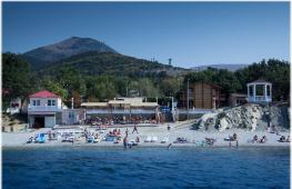
For a classic seaside holiday, it’s better to go to Makhachkala, Kaspiysk or Izberbash - that’s where not only good sandy beaches, but also decent recreation centers. The range of entertainment on the seashore on the Dagestan side is quite wide: swimming, healing mud springs, windsurfing, kiting, rock climbing and paragliding.
The only disadvantage of this direction is the underdeveloped infrastructure.
In addition, among some Russian tourists There is an opinion that Dagestan is far from the most peaceful territory that is part of the North Caucasus Federal District.
Kazakhstan
A much calmer environment can be found in the Kazakh resorts of Kuryk, Atyrau and Aktau. The last one is the most popular tourist city Kazakhstan: there are many good entertainment venues and well-maintained beaches. In summer, the temperature here is very high, reaching up to +40 degrees during the daytime, and dropping only to +30 at night.
Disadvantages of Kazakhstan tourist country- the same poor infrastructure and rudimentary transport connection between regions.
Azerbaijan
The most the best places Baku, Nabran, Lankaran and other Azerbaijani resorts are considered for holidays on the Caspian coast. Fortunately, everything is fine with the infrastructure in this country: for example, several modern comfortable hotels with swimming pools and beaches have been built in the Absheron Peninsula area.
However, in order to enjoy a holiday on the Caspian Sea in Azerbaijan, you need to spend a lot of money. In addition, you can only get to Baku quickly enough by plane - trains rarely run, and the journey from Russia itself takes two to three days.
Tourists should not forget that Dagestan and Azerbaijan are Islamic countries, so all “non-believers” need to adapt their usual behavior to local customs.
If you follow simple rules of stay, nothing will spoil your vacation on the Caspian Sea.
In dry and hot climates, a large amount of sea water evaporates, water molecules pass into the air. Thus, every year such a huge amount of water particles is carried away from the surface of the Caspian Sea that all together they would fill a bowl with a volume of several hundred cubic kilometers. This amount of water could fill ten such reservoirs as Kuibyshevskoye.
But can water from the surface of the sea get into the bottom layers of the Caspian Sea, to a depth of 900-980 meters?
This is possible provided that the density of the surface layers of water is greater than the density of the bottom layers.
It is known that the density of sea water depends on salinity and temperature. The more salts the water contains, the denser it is, and therefore heavier. High temperature water is less dense than cold water. Only at low temperatures (about 0-4° Celsius) is the opposite relationship given, when water, heating up, becomes more dense.
High salinity of the surface layers of the sea is created in the hot season, when the water evaporates strongly, but the salt remains in the sea. At this time, the salinity of surface waters turns out to be no less, and even slightly greater than the salinity of deep and near-bottom layers.
The temperature of surface waters in the warm season is the same everywhere, about 25-28°, that is, five times higher than at a depth of 150-200 meters. With the onset of the cold season, the temperature of the surface layers decreases and during a certain period it turns out to be 5-6° above zero.
The temperature of the bottom and deep (deeper than 150-200 m) layers of the Caspian Sea is the same (5-6°), practically unchanged throughout the year.
Under these conditions, it is possible for denser surface cold and highly saline water to sink into the bottom layers.
Only in the southern regions of the Caspian Sea the surface water temperature, as a rule, does not drop to 5-6° even in winter. And, although the descent of surface water into depth cannot directly occur in these areas, water that has descended from the surface to more depth is brought here by deep currents. northern parts seas.
A similar phenomenon is observed in the eastern part of the border zone between the Middle and Southern Caspian Seas, where cooled surface waters descend along the southern slope of the border underwater threshold and then follow a deep current into the southern regions of the sea.
This widespread mixing of surface and deep waters is confirmed by the fact that oxygen was found at all depths of the Caspian Sea.
Oxygen can only reach depths with the surface layers of water, where it comes directly from the atmosphere or as a result of photosynthesis.
If there were no continuous supply of oxygen to the bottom layers, it would quickly be absorbed by animal organisms there or spent on the oxidation of soil organic matter. Instead of oxygen, the bottom layers would be saturated with hydrogen sulfide, which is what is observed in the Black Sea. The vertical circulation in it is so weak that oxygen in sufficient quantities does not reach the depth, where hydrogen sulfide is formed.
Although oxygen has been found at all depths of the Caspian Sea, it is not in the same quantity in different seasons of the year.
The water column is richest in oxygen in winter. The harsher the winter, that is, the lower the surface temperature, the more intense the aeration process occurs, which reaches the deepest parts of the sea. Conversely, several warm winters in a row can cause the appearance of hydrogen sulfide in the bottom layers and even the complete disappearance of oxygen. But such phenomena are temporary and disappear during the first more or less severe winter.
The upper water column to a depth of 100-150 meters is especially rich in dissolved oxygen. Here the oxygen content ranges from 5 to 10 cubic meters. cm in liter. At depths of 150-450 m, there is much less oxygen - from 5 to 2 cubic meters. cm in liter.
Below 450 m there is very little oxygen and life is represented very sparsely - several species of worms and mollusks, small crustaceans.
Mixing of water masses is also caused by surge phenomena and waves.
Waves, currents, winter vertical circulation, surges, and surges operate constantly and are important factors in water mixing. It is not surprising, therefore, that no matter where we take a water sample in the Caspian Sea, its chemical composition will be constant everywhere. If there were no mixing of waters, all living organisms at great depths would die out. Life would only be possible in the photosynthetic zone.
Where the waters mix well and this process occurs quickly, for example in shallow areas of the seas and oceans, life is richer.
The constancy of the salt composition of the water of the Caspian Sea is a general property of the waters of the World Ocean. But this does not mean that the chemical composition of the Caspian Sea is the same as in the ocean or in any sea connected to the ocean. Consider a table showing the salt content in the waters of the ocean, the Caspian Sea and the Volga.
|
Carbonates (CaCO 3) |
Sulfates CaSO 4, MgSO 4 |
Chlorides NaCl, KCl, MgCl 2 |
Average water salinity ‰ |
|
|
Ocean |
0,21 |
10,34 |
89,45 |
|
|
Caspian Sea |
1,24 |
30,54 |
67,90 |
12,9 |
|
Volga river |
57,2 |
33,4 |
The table shows that ocean water has very little in common with river water in terms of salt composition. In terms of salt composition, the Caspian Sea occupies an intermediate position between the river and the ocean, which is explained by the great influence of river runoff on the chemical composition of Caspian water. The ratio of salts dissolved in water Aral Sea, is closer to the salt composition river water. This is understandable, since the ratio of the volume of river flow to the volume of water in the Aral Sea is much greater than for the Caspian Sea. A large number of sulphate salts in the Caspian Sea gives its water a bitter-salty taste, distinguishing it from the waters of the oceans and seas connected to them
The salinity of the Caspian Sea continuously increases towards the south. In the pre-estuary space of the Volga, a kilogram of water contains hundredths of a gram of salts. In the eastern regions of the Southern and Middle Caspian Sea, salinity reaches 13-14‰
The concentration of salts in Caspian water is low. So, in this water you can dissolve almost twenty times more salts than are present in it.
B.A. Shlyamin. Caspian Sea. 1954
| <<Назад |
Many place names can be misleading to people who are not keen on geography. Could it be that an object designated as a sea on all maps is actually a lake? Let's figure it out.
The history of the appearance of the Caspian Sea?
14,000,000 years ago, the Sarmatian Sea existed on the planet. It included the modern Black, Caspian and Azov seas. About 6,000,000 years ago, due to the rise of the Caucasus Mountains and the decrease in water levels in the Mediterranean Sea, it divided, forming four different seas.
The Caspian is inhabited by many representatives of the fauna of Azov, which once again confirms that these reservoirs were once one whole. This is one of the reasons why the Caspian Sea is considered a lake.
The name of the sea comes from the ancient tribes of the Caspian Sea. They inhabited its shores in the first millennia BC and were engaged in horse breeding. But over the many hundreds of years of its existence, this sea has had many names. It was called Derbentsky, Saraisky, Girkansky, Sigai, Kukkuz. Even in our time, for residents of Iran and Azerbaijan, this lake is called Khazar.
Geographical location
Two parts of the world - Europe and Asia - are washed by the waters of the Caspian Sea. The coastline covers the following countries:
- Turkmenistan
- Russia
- Azerbaijan
- Kazakhstan
The length from north to south is about one thousand two hundred kilometers, the width from west to east is about three hundred kilometers. The average depth is about two hundred meters, the greatest depth is about a thousand kilometers. The total area of the reservoir is more than 370,000 square kilometers and is divided into three climatic and geographical zones:
- Northern
- Average
- Southern Caspian
The water area includes six large peninsulas and about fifty islands. Their total area is four hundred square kilometers. The largest islands are Dzhambaisky, Ogurchinsky, Chechen, Tyuleniy, Konevsky, Zyudev and the Absheron Islands. About one hundred and thirty rivers flow into the Caspian Sea, including the Volga, Ural, Atrek, Sefirud, Terek, Kura and many others.
Sea or lake?
The official name used in documentation and cartography is the Caspian Sea. But is this true?
In order to have the right to be called a sea, any body of water must be connected to the world's oceans. In the case of the Caspian Sea, this is not reality. The Caspian Sea is separated by almost 500 km of land from the nearest sea, the Black Sea. This is a completely enclosed body of water. The main differences between the seas:
- The seas can be fed by waterways - rivers.
- The external seas are directly connected to the ocean, that is, they have access to it.
- Inland seas are connected to other seas or oceans by straits.
The Caspian received the right to be called a sea primarily because of its impressive size, which is more typical of seas rather than lakes. In area it surpasses even Azov. Also no small role was played by the fact that not a single lake washes the shores of five states at once.
It is worth noting that the structure of the Caspian Sea bottom is of the oceanic type. This happened due to the fact that it was once part of the ancient World Ocean.
Compared to other seas, the percentage of salt saturation in it is very weak and does not exceed 0.05%. The Caspian Sea is fed only by rivers flowing into it, like all lakes on the globe.
Like many seas, the Caspian is famous for its powerful storms. The height of the waves can reach eleven meters. Storms can occur at any time of the year, but they are most dangerous in autumn and winter.
In fact, the Caspian Sea is the largest lake in the world. Its waters are not subject to international maritime laws. The territory of waters is divided between countries on the basis of laws adopted for lakes, and not for seas.
The Caspian Sea has rich mineral resources such as oil and gas. Its waters are inhabited by more than one hundred and twenty species of fish. Among them are the most valuable sturgeons, such as stellate sturgeon, sturgeon, sterlet, beluga, and thorn. 90% of the world's sturgeon catch comes from the Caspian Sea.
Interesting features:
- Scientists around the world have not yet come to a clear conclusion as to why the Caspian Sea is considered a lake. Some experts even suggest considering it a “lake-sea” or an “inland” sea, like the Dead Sea in Israel;
- The deepest point of the Caspian Sea is more than one kilometer;
- Historically, it is known that the total water level in the reservoir has changed more than once. The exact reasons for this are still not understood;
- It is the only body of water separating Asia and Europe;
- The largest water artery feeding the lake is the Volga River. It is this that carries the bulk of the water;
- Thousands of years ago the Caspian Sea was part of the Black Sea;
- In terms of the number of fish species, the Caspian Sea is inferior to some rivers;
- The Caspian Sea is the main supplier of the most expensive delicacy - black caviar;
- The water in the lake is completely renewed every two hundred and fifty years;
- The territory of Japan is smaller than the area of the Caspian Sea.
Ecological situation
Intervention into the ecology of the Caspian Sea regularly occurs due to the extraction of oil and natural resources. There are also interventions in the fauna of the reservoir, cases of poaching and illegal fishing of valuable fish species are frequent.
The water level in the Caspian Sea is falling every year. This is due to global warming, due to the influence of which the water temperature on the surface of the reservoir increased by one degree and the sea began to actively evaporate.
It is estimated that water levels have fallen by seven centimeters since 1996. By 2015, the level of the fall was about one and a half meters, and the water continues to fall.
If this continues, in a century the shallowest part of the lake may simply disappear. This will be the part that washes the borders of Russia and Kazakhstan. If global warming intensifies, the process may accelerate and this will happen much earlier.
It is known that long before the onset of global warming, the water level in the Caspian Sea underwent changes. The water kept rising and then falling. Scientists still cannot say exactly why this happened.
The Caspian Sea is the largest lake on our planet, which is located in a depression of the earth’s surface (the so-called Aral-Caspian Lowland) on the territory of Russia, Turkmenistan, Kazakhstan, Azerbaijan and Iran. Although they consider it as a lake, because it is not connected with the World Ocean, but by the nature of the formation processes and history of origin, by its size, the Caspian Sea is a sea.
The area of the Caspian Sea is about 371 thousand km 2. The sea, stretching from north to south, has a length of about 1200 km and an average width of 320 km. The length of the coastline is about 7 thousand km. The Caspian Sea is located 28.5 m below the level of the World Ocean and its greatest depth is 1025 m. There are about 50 islands in the Caspian Sea, mostly small in area. The large islands include such islands as Tyuleniy, Kulaly, Zhiloy, Chechen, Artem, Ogurchinsky. There are also many bays in the sea, for example: Kizlyarsky, Komsomolets, Kazakhsky, Agrakhansky, etc.
The Caspian Sea is fed by more than 130 rivers. The largest amount of water (about 88% of the total flow) is brought by the rivers Ural, Volga, Terek, Emba, which flow into the northern part of the sea. About 7% of the flow comes from the large rivers Kura, Samur, Sulak and small ones that flow into the sea on the west coast. The rivers Heraz, Gorgan, and Sefidrud flow into the southern Iranian coast, bringing only 5% of the flow. Not a single river flows into the eastern part of the sea. The water in the Caspian Sea is salty, its salinity ranges from 0.3‰ to 13‰.
Shores of the Caspian Sea
The shores have different landscapes. The shores of the northern part of the sea are low and flat, surrounded by low-lying semi-desert and somewhat elevated desert. In the south, the shores are partly low-lying, they are bordered by a small coastal lowland, behind which the Elburz ridge runs along the coast, which in some places comes close to the shore. In the west, the Greater Caucasus ranges approach the coast. In the east there is an abrasion coast, carved out of limestone, and semi-desert and desert plateaus approach it. The coastline changes greatly due to periodic fluctuations in water levels.
The climate of the Caspian Sea is different:
Continental in the north;
Moderate in the middle
Subtropical in the south.
At the same time, there are severe frosts and snowstorms on the northern shore, while fruit trees and magnolias bloom on the southern shore. In winter, strong storm winds rage at sea.
On the coast of the Caspian Sea there are large cities and ports: Baku, Lankaran, Turkmenbashi, Lagan, Makhachkala, Kaspiysk, Izberbash, Astrakhan, etc.
The fauna of the Caspian Sea is represented by 1809 species of animals. More than 70 species of fish are found in the sea, including: herring, gobies, stellate sturgeon, sturgeon, beluga, white fish, sterlet, pike perch, carp, bream, roach, etc. Of the marine mammals, only the smallest in the world, the Caspian seal, is found in the lake. not found in other seas. The Caspian Sea lies on the main migratory route of birds between Asia, Europe and the Middle East. Every year, about 12 million birds fly over the Caspian Sea during migration, and another 5 million usually winter here.
Vegetable world
The flora of the Caspian Sea and its coast includes 728 species. Basically, the sea is inhabited by algae: diatoms, blue-greens, red, characeae, brown and others, of the flowering ones - rupee and zoster.
The Caspian Sea is rich in natural resources; many oil and gas fields are being developed in it; in addition, limestone, salt, sand, stone and clay are also mined here. The Caspian Sea is connected by the Volga-Don Canal with the Sea of Azov, and shipping is well developed. A lot of different fish are caught in the reservoir, including more than 90% of the world's sturgeon catch.
The Caspian Sea is also a recreation area; on its shores there are holiday homes, tourist centers and sanatoriums.
Related materials:
Caspian Sea The Caspian Sea (Greek: Káspion pélagos, Latin: Caspium Mare), the world's largest enclosed body of water on the territory of the USSR (RSFSR, Kazakh SSR, Turkmen SSR, Azerbaijan SSR) and Iran. It is often considered to be the greatest lake on Earth, which is inaccurate, since in terms of its size, the nature of its processes, and the history of its development, the lake is a sea. It got its name from the ancient tribes of the Caspian Sea (See Caspian Sea), who lived in the eastern part of the Caucasus. Other historical names -
Girkanskoe, Khvalynskoe (Khvalisskoe), Khazarskoe - also by the names of the ancient peoples who lived on its shores. Physico-geographical sketch. General information. K. m. is extended from N. to S. by almost 1200 km, average width 320 km, the length of the coastline is about 7 thousand. km(of which more than 6 thousand. km within the USSR). Area about 371 thousand. km 2 ; level at 28.5 m below sea level (1969). Maximum depth 1025 m. In 1929, before a significant decrease in the level of the K. m., its area was 422 thousand. km 2. The largest bays: in the north - Kizlyarsky, Komsomolets, in the east - Mangyshlaksky, Kenderli, Kazakhsky, Kara-Bogaz-Gol, Krasnovodsky, in the west - Agrakhansky, Baku Bay; in the south there are shallow lagoons. There are up to 50 islands, mostly small (total area about 350 km 2),
the most significant are Kulaly, Tyuleniy, Chechen, Artem, Zhiloy, Ogurchinsky. The most significant rivers flow into the northern part of the sea - the Volga, Emba, Ural, Terek, the total annual flow of which is about 88% of the total river flow into the Caspian Sea. The large rivers Sulak, Samur, Kura and a number of smaller ones (about 7% of the flow) flow into the western coast. The remaining 5% of the flow comes from the rivers of the Iranian coast (Gorgan, Heraz, Sefidrud). On the eastern coast, including the coast of Kara-Bogaz-Gol, there is not a single permanent watercourse. Shores. The shores of the northern part of the Caspian Sea are low-lying and very sloping, characterized by the widespread development of drying areas formed as a result of surge phenomena; deltaic shores are also developed here (deltas of the Volga, Ural, and Terek). In general, the coasts of the northern part are growing rapidly, which is facilitated by a drop in sea level, rapid growth of deltas and an abundant supply of terrigenous material. The western shores of the Caucasus are also mostly accumulative (numerous bay-bars and spits), while some areas on the coasts of Dagestan and the Absheron Peninsula are abrasive. On the eastern coast of the sea, abrasion coasts predominate, carved out of limestones that make up the adjacent semi-desert and desert plateaus. There are also accumulative forms: the Karabogaz bay-bar, separating the largest bay of the Caspian Sea from the sea - Kara-Bogaz-Gol, the Krasnovodskaya and Kenderli spits. To the south of the Krasnovodsk Peninsula, accumulative shores predominate. Relief. Based on the nature of the relief and hydrological features, the Caspian Sea is usually divided into the Northern Caspian, Middle Caspian, and Southern Caspian. Northern Caspian Sea (area about 80 thousand sq. km 2) -
the shallowest part of the sea with depths of 4-8 m.
The bottom topography is a slightly undulating accumulative plain with a series of banks and accumulative islands, the so-called Mangyshlak threshold, separating the Northern Caspian from the Middle. Within the Middle Caspian Sea (area about 138 thousand sq. km 2) stand out: Derbent depression (maximum depth 788 m),
shelf and continental slope, complicated by underwater landslides and canyons; On the northern, rather gentle slope, relics of ancient river valleys were discovered. In the south, the depression of the Middle Caspian is separated from the depression of the Southern Caspian by the Absheron threshold, on which a number of banks and islands are located. Depression of the Southern Caspian Sea (maximum depth 1025 m), accounting for about 1/3 of the sea's area, has a narrow shelf off the western and southern (Iranian) coasts, and a much wider shelf off the eastern coast. The bottom of the depression is a flat abyssal plain. In the northern part of the depression there are several underwater ridges with northwestern and southeastern trends. Geological structure and minerals. The northern part of the Caspian Sea is the outskirts of the Caspian syneclise of the East European Platform; The Mangyshlak threshold is structurally connected with the Hercynian buried shaft of Karpinsky on the western shore of the sea and with the Mangyshlak mountains on the eastern shore. The bottom of the Middle Caspian has a heterogeneous structure. Its eastern part is a submerged section of the Epihercynian Turanian Platform; The Derbent depression, as well as the western sections of the shelf and continental slope, is the marginal trough of the Greater Caucasus geosyncline. The Absheron threshold corresponds to one of the branches of the newest structures that formed on the subsidence of the folded formations of the Greater Caucasus and connecting them with the folded structures of the Kopetdag. The Southern Caspian Sea is characterized by a suboceanic structure of the earth's crust; there is no granite layer here. Under a sedimentary layer with a thickness of up to 25 km(which obviously indicates the great antiquity of the Southern Caspian basin) there is a basalt layer up to 15 km.
Until the Upper Miocene, the Caspian Sea as a sea basin in its geological history was closely connected with the Black Sea. After the Upper Miocene folding, this connection was interrupted, and the K. m. turned into a closed reservoir. Communication with the ocean resumed in the Upper Pliocene, during the Akchagyl Age. During the Anthropocene, due to the alternation of glacial and post-glacial eras on the East European Plain, the Caspian Sea repeatedly experienced transgressions (Baku, Khazar, Khvalyn) and regressions, traces of which were preserved in the form of terraces on the sea coast and in the stratigraphy of ancient Caspian deposits. On the shelf, terrigenous-shelly sands, shell, and oolitic sands are common; deep-sea areas of the bottom are covered with siltstone and silty sediments with a high content of calcium carbonate. In some areas of the bottom, bedrock of Neogene age is exposed. At the bottom of the Kazan Sea there are rich deposits of oil and gas. The Absheron threshold, Dagestan and Turkmen areas of the sea are oil and gas bearing areas. The areas of the seabed adjacent to Mangyshlak, as well as the Mangyshlak threshold, are promising for oil and gas. The Kara-Bogaz-Gol Bay is the largest deposit of chemical raw materials (in particular, mirabilite). Climate. The main pressure centers that determine the atmospheric circulation in the sea region are the spur of the Asian maximum in winter and the spurs of the Azores maximum and South Asian minimum in the summer. Characteristic features of the climate are: significant continentality, the predominance of anticyclonic weather conditions, dry winds, severe frosty winters (especially in the northern part), sharp temperature changes throughout the year, poor precipitation (excluding the southwestern part of the reservoir). Cyclonic activity develops on atmospheric fronts, which is also an important element of climate and weather in the Caspian Sea. In the northern and middle parts of the Caucasus, from October to April, winds of eastern directions prevail, and from May to September - winds of northwestern directions; in the southern part of the sea the monsoon wind pattern is most pronounced. The strongest winds are found in the region of the Absheron Peninsula (Baku north, blowing mainly in autumn), the eastern coast of the middle part and the northwestern region of the northern part; There are frequent storms here, with wind speeds reaching more than 24 m/sec.
The average long-term air temperature in the warm months (July - August) over the entire sea is 24-26 °C, the absolute maximum (up to 44 °C) is observed on the east coast. In the winter months, the temperature varies from -10 °C in the north to 12 °C in the south. An average of 200 falls over the sea mm precipitation per year, on the west coast - up to 400 mm,
in the arid east - 90-100 mm,
in the subtropical southwestern part of the coast - up to 1700 mm. Evaporation from most of the sea surface is very high - up to 1000 mm in year; in the eastern part of the South Caspian Sea and in the area of the Absheron Peninsula - up to 1400 mm in year. Hydrological regime. In the Kazan Sea, cyclonic circulation of water predominates, determined mainly by river runoff and prevailing winds. Masses of water move from north to south along the western coast of the sea to the Absheron Peninsula, where the current is divided: one branch continues along the western coast, the other crosses the K. m. in the area of the Absheron threshold and, at the eastern coast, it connects with the waters moving to the north. along the eastern shore from the South Caspian. In the Southern Caspian, cyclonic circulation is also observed, but less clearly expressed, and between Baku and the mouth of the river. Chickens complicated by local anticyclonic circulation. In the Northern Caspian Sea, unstable wind currents of various directions predominate. Their speed is usually 10-15 cm/sec, with strong winds coinciding with the direction of the currents, the speed can reach 30-40 and even 100 cm/sec. The frequent recurrence of moderate and strong winds causes a large number of days with significant waves. Maximum observed wave height up to 11 m- in the area of the Absheron threshold. The water temperature in summer on the surface averages 24-26°C, in the south - up to 29°C, in Krasnovodsk Bay - up to 32°C. On the eastern coasts in July and August the temperature sometimes drops to 10-12 °C. This phenomenon is associated with the driving influence of winds and the rise of deep waters. In winter, significant temperature contrasts are observed: in the north - negative temperatures (up to -0.5 °C), in the Middle Caspian 3-7 °C, in the Southern Caspian 8-10 °C. The northern part of the sea usually freezes at 2-3 months., ice thickness reaches 2 m. In the Middle Caspian, individual shallow bays freeze over in severe winters. There are frequent cases of intense breaking of ice by the wind and its drift from the Northern Caspian Sea to the south along the western coast. In some years, floating ice reaches the area of the Absheron Peninsula and is capable of causing significant damage to hydraulic structures in the sea. The average water salinity is 12.7-12.8 ‰, the maximum (not counting the Kara-Bogaz-Gol Bay) off the eastern shores is up to 13.2 ‰, the minimum is in the north-west. - 1-2 ‰. Fluctuations in salinity over the sea area, vertically, and in time are insignificant, and only in the north are they more noticeable due to fluctuations in the Volga runoff. The composition of salts differs from the usual ocean salt in the higher content of sulfates, calcium carbonates, magnesium and, accordingly, a lower content of chlorides, which is due to the influence of river runoff. Vertical mixing of water in winter covers the entire water column in the Northern Caspian and the 200-300 layer m in deep-sea areas, in summer and autumn it is limited to the top layer of 15-30 m. During these seasons, at the lower boundary of the upper well-heated and mixed layer (15-30 m) an intense layer of temperature jump (several degrees per meter) is formed, preventing the spread of heat into the deep layers of the sea. Level fluctuations. Short-term non-periodic fluctuations in the level of oxygen are caused by surge phenomena, which in the north can cause a short-term increase in the level by 2.5-2 m or downgrade to 2 m. Seiches are observed with a period of 10 min to 12 h with amplitude up to 0.7 m. There are slight seasonal fluctuations in level (about 30 cm). The water level is subject to significant long-term and secular fluctuations, determined mainly by changes in its water balance. Based on geological, archaeological, historical, and geomorphological data, it has been established that the high level of K. m. (up to 22 m) was noted 4-6 thousand years ago, at the beginning of the century. e. and at the beginning of the 19th century. (New Caspian transgression). It is also known that in the 7th-11th centuries. n. e. was low (perhaps 2-4 m below modern). The last major decline in level occurred since 1929 (when the level was around 26 m) until 1956-57. Currently the level fluctuates within a few cm around the 28.5 mark m. The reasons for the latest drop in level, in addition to climatic changes, which caused a decrease in river flow in the Caucasus and an increase in evaporation from its surface, were also hydraulic engineering construction on the Volga (the creation of large artificial reservoirs) and the consumption of river water for irrigation of dry lands and for production needs. The water flow of the K. m. in the Kara-Bogaz-Gol Bay also negatively affects the water balance, the level of which is 4 m below the level of the Caspian Sea. In general, the components of the water balance for 1970: arrival - precipitation 66.8 km 3, river flow 266.4 km 3, underground inflow 5 km 3, flow rate - evaporation 357.3 km 3, drainage to Kara-Bogaz-Gol 4 km 3, water intake from the sea 1 km 3. The excess of the outflow portion over the inflow of water determines the average annual decrease in level (for the period 1966-67) by 7 cm. To prevent further decline in sea level (by 2000, a decrease of 2 m) a number of activities are being developed. There is a project for transferring the flow of the northern rivers - Vychegda and Pechora - in the Volga basin, which will give the Volga and K. m. about 32 km 3 waters per year; A project was developed (1972) to regulate the flow of Caspian waters into the Kara-Bogaz-Gol Bay. The flora and fauna of the K. m. are rather poor in species composition, but significant in biomass. The Kazan region is home to more than 500 species of plants and 854 species of fish and animals, diverse in origin. The predominant plants in the region are blue-green algae and diatoms (rhizosoleniums, etc.). Among the recent invaders there are many red and brown algae. Of the flowering plants, the most common are Zostera and Ruppia. The largest biomass is produced by charophytic algae (up to 30 kg by 1 m 3 bottoms). In origin, the fauna is mainly of Neogene age, which experienced great changes due to frequent and significant fluctuations in salinity. This group includes fish - sturgeons, herrings, sprat, gobies, pugheads, mollusks - dracenas and cordates, and other invertebrates - gammarids, polychaetes, sponges, and one type of jellyfish. In addition, 15 species of invaders from the Arctic and Mediterranean basins live here. A noticeable group is represented by organisms of freshwater origin (fish - pike perch). In general, a high degree of endemism is characteristic. Some organisms moved into the Kazan sea quite recently, either as a result of introduction on the bottoms of sea vessels (mainly various fouling organisms, for example, mytilaster, rhizosolenia algae, balanus, and crabs), or through deliberate acclimatization by humans (for example, from fish - mullet, from invertebrates - Nereis, Syndesmia). History of the study. Documentary evidence of the acquaintance of Russians with the Caucasus and their voyages along it dates back to the 9th-10th centuries. (Arabic, Armenian, Iranian ancient manuscripts). Regular studies of the Caspian Sea were started by Peter I, on whose initiative an expedition was organized in 1714-15 under the leadership of A. Bekovich-Cherkassky, who examined, in particular, the eastern shore of the Caspian Sea. In the 20s 18th century Hydrographic research of the sea was started by I. F. Soimonov in the 2nd half of the 18th century. they were continued by I.V. Tokmachev and M.I. Voinovich at the beginning of the 19th century. - Kolodkin, who was the first to perform instrumental compass surveying of the coast. In the middle of the 19th century. A detailed instrumental hydrographic survey of the coastline was carried out under the leadership of N. A. Ivashintsev. The maps created as a result of these surveys served as the basis for subsequent publications of sea charts for the Caspian Sea until the 30s. 20th century In the study of natural conditions of K. m. in the 19th century. scientists made a great contribution - P. S. Pallas, S. G. Gmelin, G. S. Karelin, K. M. Baer, G. V. Abikh, O. A. Grim, N. I. Andrusov, I. B Spindler. In 1897, the Astrakhan Research Station (now the Caspian Institute of Fisheries) was founded. In 1866, 1904, 1912-13, 1914-15, expeditionary research on the hydrology and hydrobiology of the Caspian was carried out under the leadership of N. M. Knipovich. This work was continued after 1917 by the Caspian Expedition created under the USSR Academy of Sciences, also headed by Knipovich. In the first decades after the October Revolution, the research of the Owls played an outstanding role in the study of the geological structure and oil content of the Absheron Peninsula and the geological history of the Caucasus. geologists I.M. Gubkin, D.V. and V.D. Golubyatnikovs, P.A. Pravoslavlev, V.P. Baturin, S.A. Kovalevsky. B. A. Appolov, V. V. Valedinsky, K. P. Voskresensky, and L. S. Berg made significant contributions to the study of water balance and fluctuations in the water level at this time. After the Great Patriotic War of 1941–45, systematic, comprehensive research was launched in the sea, aimed at studying the hydrometeorological regime, biological conditions, and geological structure of the sea [MSU, the Institute of Geography of the Academy of Sciences of the Azerbaijan SSR, the State Oceanographic Institute and the observatories of the hydrometeorological service. Institutes of Geology and Mineral Development (IGIRGI) and Physics of the Earth of the USSR Academy of Sciences, Laboratory of Aeromethods and the All-Russian Research Institute of Geophysics of the USSR Ministry of Geology, Caspian Institute of Sturgeon Fisheries and other scientific institutions of the Republican Academy of Sciences and ministries]. Economic-geographical sketch. The region has long been famous as a fishing area for valuable varieties of fish, especially sturgeon (82% of the world catch), herring, and freshwater fish (bream, pike perch, roach, carp). As a result of a drop in sea level (which resulted in the disappearance of valuable spawning grounds), regulation of the flow of the Volga, Kura and Araks rivers, which worsened the breeding conditions of anadromous and semi-anadromous fish, etc. the quantity and catch of primarily valuable varieties of fish (herring, sturgeon) decreased sharply. In 1936, the gross fish catch was about 500 thousand. T, in 1956 - 461 thousand. T(respectively, the catch of sturgeon is 21.5 and 15.0, roach - 197 and 18, pike perch - 55 and 8.4 thousand. T). The relatively small reduction in gross catch is explained by a sharp increase in the production of low-value fish, mainly sprat. Due to the decrease in the number of sturgeon, work is underway to breed and restore valuable fish species. In 1924, oil production began for the first time in Ilyich Bay (Baku region), but production increased especially after the Great Patriotic War of 1941-45. Oil is extracted at sea from overpasses (Oil Rocks) and artificial islands. The main regions are Priapsheronsky, Sangachalsky on the western coast, Chelekensky on the eastern coast. Offshore oil fields provide more than 50% of all oil produced in the Azerbaijan SSR. The extraction of sodium sulfate, mirabilite and epsomite in the Kara-Bogaz-Gol region is of great economic importance. The ever-increasing need for fresh water has caused the appearance of installations for desalination of sea water in the Caucasus region; the largest of them (for the production of fresh water for industrial and domestic needs in adjacent desert and semi-desert areas) are being built (1972) in. Shevchenko and Krasnovodsk. K. m. is of great transport importance both for internal transportation and for external relations. The main cargoes transported across the Caspian Sea are oil, timber, grain, cotton, rice, and sulphate. The largest ports - Astrakhan, Baku, Makhachkala, Krasnovodsk, Shevchenko - are also connected by regular flights of passenger ships. Sea railways run between Baku and Krasnovodsk. ferries. A ferry crossing between Makhachkala and Shevchenko is being designed (1972). In Iran, the main ports are Pahlavi and Bandar Shah. Lit.: Fluctuations in the level of the Caspian Sea, M., 1956; Fedorov P.V., Stratigraphy of Quaternary sediments and the history of the development of the Caspian Sea, M., 1957; Geological structure of the underwater slope of the Caspian Sea, M., 1962; Materials of the All-Union Conference on the Problem of the Caspian Sea, Baku, 1963; Zenkevich L. A., Biology of the seas of the USSR, M., 1963; Leontyev O.K., Khalilov A.I., Natural conditions for the formation of the shores of the Caspian Sea, Baku, 1965; Pakhomova A. S., Zatuchnaya B. M., Hydrochemistry of the Caspian Sea, Leningrad, 1966; Geology of oil and gas fields of Azerbaijan, M., 1966; Caspian Sea, M., 1969; Comprehensive studies of the Caspian Sea. Sat. Art., V. 1, M., 1970; Gul K.K., Lappalainen T.N., Polushkin V.A., Caspian Sea, M., 1970; Gul K.K., Zhilo P.V., Zhirnov V.M., Bibliographical annotated reference book on the Caspian Sea. Baku, 1970. K. K. Gul, O. K. Leontyev.
Great Soviet Encyclopedia. - M.: Soviet Encyclopedia. 1969-1978 .
Synonyms:See what the “Caspian Sea” is in other dictionaries:
It is drainless and washes the shores of Russia (Dagestan, Kalmykia, Astrakhan region) and Azerbaijan, Iran, Kazakhstan, Turkmenistan. The earliest mention of the Caspian Sea is found in Assyrian. cuneiform inscriptions (VIII-VII centuries BC), where it... ... Geographical encyclopedia
CASPIAN SEA, the world's largest endorheic lake. Area 376 thousand km2. Lies 27.9 m below sea level (1986). From 1929 to 1977 there was a decline in the level, and from 1978 a rise began. In the Northern Caspian the depth is 5-8 m, in the Middle Caspian up to 788 m... Modern encyclopedia