The river of beer is a Montenegrin beauty with a stormy temperament. Montenegro
This is not a joke, there really is such a river in Montenegro)
An amazingly beautiful place. Therefore, today’s post will be about the journey from Bar to the Piva River))
It's interesting that these two places are on opposite ends of the country.
A few words about the trip.
Continuing the year of hospitality according to the president’s behest, this time we hosted my dad.
We rented it for two days and drove it to distant lands for new experiences. The faithful dog also traveled with us.

The route of the first day was as follows: Bar - Zabljak Crnojevica (on Lake Skadar) - Pluzine - Durmitor - Black Lake- Djurdjevic Bridge - Kolasin - Bar.
And on the second day we took a ride along the Boka Kotorska, all the way to Herceg Novi. Here you can conveniently see on the map what is where.
To be at least a little consistent, today I will show and tell you about the first part of the route.
The main goal was to go north and see national park Durmitor. But it turned out that the path itself was just as interesting and beautiful.
The very first stop was Zabljak Crnojevica - ancient fortress on Lake Skadar.

If you look closely, you can see a monastery on the mountain (above, to the right of the cloud).


I really liked the surroundings of Niksic, so now I want to go there and look at everything in detail.


And lambs!

Around every turn a new landscape opens up. And after the next one such beauty awaited us!

This is the Piva River) In the middle of a high canyon, with rich turquoise water.


I learned about the city of Pluzine quite by accident. More precisely, not even about him, but about the fact that the most beautiful road to Durmitor goes through it.

As it turned out, the city is completely new, built in the 80s, when a hydroelectric power station was created in these parts, and with it the Piva Lake.
It is located almost on the border with Bosnia. A soulful little town in the middle of a canyon. There are modern high-rise buildings (most of them)

and cute rural houses with pigs)

Piva Lake is beautiful from any angle.

And especially from above)


It’s hard to believe from the photo that this is a mountain landscape. But in fact, Basya and I were running at an altitude of about 2000 meters.

And they ran)

So through mountains, tunnels and serpentines we got to Durmitor. But that's a completely different story)

Photo review of a trip to the north of Montenegro to the Durmitor National Park, to Lake Piva, the canyons of the Moraca and Tara rivers, and the Djurdjevic Bridge.
In the north and northeast of the country there are the main natural ones, so if you want to see other landscapes (not the same as on the coast), you can safely go towards Durmitor.
What to see in the north of Montenegro
The map shows the places and observation platforms described in the article
Piva lake and monastery
Pivsko jezero- an extremely picturesque artificial reservoir, the largest reservoir fresh water on the territory of Europe. You can rent a boat and sail on Lake Piva.
Piva Monastery 16th century stands on the banks of the Piva River on the way to Lake Piva. The monastery looks very simple; the church does not have a dome.
The monastery is unique in that it was built during the rule of the Turks. This explains the simple appearance of the building, which can be mistaken for an ordinary house. This was done on purpose so as not to attract the attention of the occupiers. But inside, all the walls and ceilings of the monastery are painted with frescoes.
Piva Lake
National Durmitor Park
Entrance - 3€
per person
Parking — 2€
per car
After admiring Lake Piva and the monastery, we go to the national. Durmitor Park along the serpentine road to see the most high peaks Montenegro.
In the national you can walk around the park Black Lake(circle 4 km, you can walk in an hour and a half). In summer people swim in this lake, but the water there is icy.
 Black Lake in the national Durmitor park
There are other marked pedestrian routes in Durmitor Park with a total length of more than 100 km.
You can climb to the top of the mountain Bobotov cook(from here in clear weather almost the whole of Montenegro is visible), go to caves, waterfalls and other lakes. A map of routes to attractions is available within the park.
 This map hangs in the park, you can take a photo and walk along it. Times and distances are indicated
 You can eat in a cafe, buy food in a store and stay overnight in the town of Zabljak at the entrance to the national park. Durmitor park.
Zabljak stands at its height 1450 meters above sea level, in national Durmitor park maximum height — 2523 meters. The mountains are cool even in summer, often cloudy, and it can rain.
Even in summer, be sure to take it with you warm clothes(bike, jacket) and closed shoes if you plan to walk around Durmitor.
Hotels near Durmitor Park
Tara River Canyon and Djurdjevic Bridge
After Durmitor we go again 20 km to the Djurdzhevich Bridge and go down to the Tara River.
The Djurdzhevich Bridge is a concrete arched road bridge across the Tara River, 365 meters long, 172 meters high from the ground. Considered the highest automobile arch bridge in Europe.
The bridge has several cafes (on one and the other side of the bridge) and souvenir shops. Parking near the bridge is free.
It is better to take photos from the observation deck, which is located on the side of Durmitor Park. If you cross the bridge, the view will be worse.
 The Djurdzhevich Bridge is full of people from excursion buses
 Canyon of the Tara River from the Djurdzhevich Bridge
  You can go down to the river along a path (about an hour there and back from the bridge)
 The Tara River flows under the bridge. You can fly over it on a zip line ( 10€ from below, quickly and scary or 20€ from above, slowly and not so scary) or on a hang glider.
Rafting is also popular (long route 4 hours - 80-90€ or short route 1.5 hours - 45-60€ ) along the Tara River.
Rafting tours are sold in the city of Zabljak, and to fly on a bungee, just come to the Djurdzhevich Bridge and buy a flight on the spot.
 Bungee flight over Tara
 Moraca River
After the Tara River canyon, you can drive towards the city of Kolasin and further south along the highway to Podgorica to see the national park along the way. Biogradska Gora park, Moraca river, monastery, Moraca river canyon and suspension bridge. All these places are marked on the map.
We didn’t have a goal to see everything at once, so we didn’t go to the Moraca River Canyon, but visited instead.
Travel route on the map

Distance from Zabljak one way - 190 km
If you go only to the national Zabljak park from Budva through Podgorica without stops, the road will go in one direction 4 hours.
How long does it take for the whole trip? Minimum 1 daylight hours to travel from the coastal resorts to the north. It took us a trip from Budva to the north and back 12 hours By beautiful roads. If you are planning walks around the national park. park, it is better to go overnight.
If you want to drive the entire circle around the sights marked on the map, then the road without stops will take more 9 o'clock(Total 519 km, most of the way along mountain serpentines).
Add to this the time spent stopping at observation platforms, walks in the mountains, lunch, bungee jumping - that’s a few more hours.
 Landscapes of provincial Montenegro
  Slansko Lake on the way to Durmitor
 How to get to Durmitor Park
1. By car
The best option. We traveled inexpensively and traveled north by car so that we could stop wherever we wanted and have time to see the most interesting things.
A trip from Budva to the north by car cost us 83€ (25€ car rental + 50€ gasoline + 8€ entry tickets to Durmitor park and parking) + lunch at a pizzeria in Zabljak for 8€ .
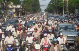
 You can drive your car on any path
  Traffic jam on the way to Durmitor Park
 Canyon location
If you ask the residents of Montenegro which canyon can be called the most interesting and beautiful, most of them will name the Tara Canyon, but some may remember Mrtvica and Moraca. Only people who are true connoisseurs of the natural beauty of Montenegro will be able to say that the canyon of the Piva River in Zabljak is one of the most beautiful. The Piva River Canyon is located on the territory of the Piva Plateau, which belongs to the municipality of Pluzhie. This amazing canyon is crossed in some places by high bridges, adding a special charm to the canyon.
Features of the canyon
The Piva River first flows through the territory of Montenegro, after which it enters Bosnia and Herzegovina, where it merges with the Tara, forming the Drina River. The sources of the Piva River are located on the slopes majestic mountain Sinyan, located next to the Piva Monastery. Thus, nature lovers can see not only natural beauty, but also ancient attractions. To do this, it is enough to include in excursion program in Zabljak, visit to the canyon of the Piva River. This trip, without a doubt, can really be enjoyed.
A tributary of the Piva River is Komarnica, which begins in the Sinyavina Mountains. Due to the fact that the length of the tributary is approximately 86 kilometers, exceeding the length of the Piva Canyon, the Piva is often called “the river with five names.” It may include the names of rivers of a water flow with a length of 120 kilometers: Tushina, Piva, Bukovica, Komarnica, Bijela.
The Piva River Canyon is one of the most beautiful and in order to see it, you need to go to the Piva Plateau, consisting of the Pivska Planina, Bioče, Maglic and Volujak mountains. This entire region allows you to understand the beauty of Zabljak’s nature and, of course, appreciate it. In addition, the length of the Piva River canyon is approximately 34 kilometers. In some places the depth reaches 1200 meters. The total catchment area of Piva is approximately 1270 square kilometers. The energy power of the Piva River is successfully used to operate a hydroelectric power station.
In 1975, the gorge of the Piva River canyon in Zabljak was blocked by the Mratina dam, located next to Scepan Polja. As a result, a reservoir was formed, known as Lake Piva. This reservoir is the second largest in all of Montenegro. Of course, the nature of these places can only cause delight, so during a trip to Zabljak, it is important to visit these amazing regions.
The Piva River is one of the most interesting rivers in Zabljak and Montenegro. She's perfect for lovers active rest. Many people are sure that the Piva Canyon is one of the most wonderful in Montenegro: the water is a pleasant emerald green color, rocks where chamois graze and golden eagles live, rich vegetation. All this fills Montenegro with the beauty of the virgin nature of Zabljak, which can evoke true admiration.
Every tourist who comes to Zabljak can visit these places, enjoy the natural beauty and have an interesting time, for example, by going hunting and fishing, rafting, mountaineering, going to hiking or on a bike ride. Regardless of the type of pastime, the nature of Zabljak reveals its beauty.
The Piva River Canyon is also famous for its unique medicinal herbs, which can help in many cases.
All beautiful rivers that I have ever seen in my life are far from Piva. It is located on the border of Montenegro and Bosnia, making this sparsely populated region even more attractive and wild thanks to its emerald color and crystal clarity. Beautiful, romantic, sometimes calm, and at certain times stormy, as if she was trying to escape from someone. I come here every summer, I have already collected several dozen photographs of this river in different years. It's time to show them and compare the changes.

I first saw this wooden bridge in June 2010, then my mother and I came north for two days to relax. We came to Scepan Polje for rafting, a Montenegrin friend said - take a walk along the river through the village/field and come to the bridge, it’s very beautiful there. He didn't cheat.

The next summer in 2011, I took my sister and her husband along a familiar path; I had only moved to live in Montenegro a few days ago, and they were traveling with me around the country for the first time. As you can see, the bridge has already partially collapsed.

Fast forward another two years - July 2013. I have already brought my cousin Lera here. As you can see, they managed to patch up the bridge over the river :)

Now let's look at the changes from the outside. Note that in this photo the Piva River is calm.

Photo from the door. my sister looks different. The bridge is in working order again and the river is raging and has a different color.

Why is this happening? The first reason is the dam. If you drive towards the town of Pluzine, you will cross the dam, and when it is turned on, the river turns from calm at this point to noisy. Why a different color? I think the lack of sun is to blame here; in the photo on the right it is already evening, the sky is gray. And on the left - earlier morning and the sun was shining. Although both photos were taken from the same bridge, the view is radically different.


The Piva River, like the Tara or Moraca, flows in a beautiful canyon. Newly 1975 ago, a hydroelectric power station was built on the river, Piva lost part of the canyon, we will never see it the same.


We cross the dam and find ourselves in a tunnel. There are 52 of them in this area...

The river looks different on both sides. Most of The river flows in a canyon, and in general its length is 34 km.


The river originates on the slope of Mount Sinyats. It flows in Montenegro, and on the border with Bosnia and Herzegovina it merges with the Tara River and forms the Drina River. This place can just be seen in the village. Scepan Polje, here on the edge of the hill there is a restaurant and houses for tourists. This place is located in the very corner on the map , on the border of 2 countries and at the confluence of 3 rivers.

The territory belongs to a Montenegrin who was the first in the country to offer rafting; now he has huge estates and many professional workers. He is the only one in the country who has the right to take exams of helmsmen, and sometimes former students and employees split off from him and go on a free-floating career. If you are going to those parts on your own for the sake of descending the Tara, I advise you to apply for to the Tara-Tour agency. They are safe, inexpensive, and have the opportunity to stay overnight, eat, and see the surrounding beauty. I once talked about rafting on Tara.
In the photo you can already see the last meters of the Piva River; it quickly turns into the Drina around the bend.

The entire length of Piva is not navigable.

The drainage basin covers 1270 sq. kilometers.


I love admiring the emerald rivers in Montenegro both up close and from the airplane window. The beauty is simply indescribable.

In this area, you can safely drink water from the rivers without fear of developing a sore stomach.


And I’ll show you a little beer of a different color, that evening it was a soft blue shade.

The current was very fast. My sister and I sat on the bridge and for a very long time we just looked at her, listened to the birds, looked at the waves.

So, from Asia Minor we return again to the Balkans, to the beautiful country of Montenegro. This and the next two posts will be about a place in the north of the country where the Piva River flows, which is especially funny, flowing into the Tara River.
Now in the upper reaches of the Piva River it is a reservoir called Piva Lake. For me - extraordinary beauty, but local residents they say that before the construction of the dam it was much more beautiful. Construction of the Piva dam, 220 meters high, began in 1967 and was completed in 1975. The town of Plužine was resettled, the old one was flooded, as well as many small villages. But more on that in the next posts. In the meantime, we admire the man-made beauties that have destroyed natural beauties.
Bridge over Piva. Simple as two pennies. No frills or decorations.

Piva Lake.


Some kind of flooded ridge can be seen under the water. Perhaps something artificial, e.g. old bridge, I do not know for sure.

Influx.


A huge reservoir of pure mountain water.

We drove up to the dam itself. Crossroads of tunnels. By the way, there are a huge number of tunnels in this area, I don’t remember exactly how many, but almost a hundred.

Pay attention to the rock formation. Looks like a dirty spring glacier. Here is a photo inside the tunnel.