Uchar Waterfall (Big Chulchinsky Waterfall). Uchar Waterfall (Unapproachable) - the youngest masterpiece of nature of the Altai Mountains Uchar Waterfall Katu Yaryk excursions
Uchar or Chulchinsky cascade- most big waterfall in Gorny Altai. Height is about 160 meters. An indescribable spectacle that is worth the effort it takes to see it.
There are two possible routes to get to the waterfall. One way by land, along the Chuysky tract to Aktash, then through the Red Gate and the Katu-Yaryk pass we descend into the valley of the Chulyshman River. Then along the river we reach the Stone Mushrooms camp site, where we stop for the night. Of course, this is a difficult and rather tedious option. The other one, which we use most often, is the path through Lake Teletskoye. This hike takes two to three days and is truly fascinating and an unforgettable journey and leaves a vivid trace of impressions on those who found the strength to overcome all the difficulties of the path and reach the waterfall.
The excursion to the Uchar waterfall begins early in the morning, almost at dawn. We get into a minibus and go to Lake Teletskoye, watching our unsteady morning dreams along the way. Having reached Teletskoye, at the pier near Artybash we transfer to a boat to cross the entire lake from one end to the other to the mouth of the mountain river Chulyshman.
Here a GAZ-66 awaits us, in which we will have to climb up the river, overcoming water obstacles in the form of streams and small rivers and a broken mountain road to the camp located opposite the gorge, which leads to the waterfall.
After settling into camp, having lunch and a little rest, we make our first foray to the famous stone mushrooms, located on the right bank of the Chulyshman River. Why do we use motor boats? local residents and cross the river, fighting the fast current and rapids.
We land on the shore and go mushroom hunting. This amazing natural phenomenon was formed with the help of rain, wind and sun. The huge stones standing on thin legs of soft rock are impressive.
We return to the shore and cross to the camp, where an evening fire awaits us, dinner and a fairly early break, since the Uchar is waiting for us at dawn. In the morning, we have breakfast, distribute a small load among the participants of the hike in the form of dry rations and bottles of water, and again we cross.
We moor, unpack our things, adjust our equipment and, shivering from the morning freshness, we begin our journey to the waterfall. The path along the gorge is quite winding with various obstacles in the form of river crossings, thorny thickets of bushes, rock slides, slippery clay slopes and quite serious rock pressure.

Fortunately, rock hooks have already been driven into the rock pressure, which is an almost vertical wall, the instructor attaches safety railings and the group carefully climbs to the other side.
The gorge along which the path runs is very beautiful, in various places there are small waterfalls and spillways, the Chulcha River roars below, except for the path, there are practically no traces of people. About 3 kilometers away, you begin to hear the growing roar of water falling from a great height, and at some point, coming around the bend of the gorge, you see a huge waterfall in front of you, but we still have to go and go to get to it. But gradually the waterfall gets closer and closer and you approach under its increasing roar. And when you finally reach your goal and stand amazed by the grandeur and scale of the picture that appears before you, you realize that it was not in vain that you came all this difficult and long way.
Here, as elsewhere in the mountains, the weather is unpredictable, it was just sunny and now the clouds are rolling in, it gets sharply cold and it starts to drizzle. In such weather, the waterfall, thundering through the drizzling rain, with its top open before our eyes, produces a completely unreal impression. It seems that a huge stream is falling straight from the sky, shrouded in splashes and wisps of fog.
We return to the camp along the already familiar path, leaving behind impressions and a camera memory full of photographs. Upon returning to the camp, we take a short rest, have a snack and get into the car to return to the pier, where a boat awaits us to cross the lake. You can write a separate song about the passage on a boat through Teletskoye - the water and mountains turn golden in the rays of the setting sun and only the white foam line behind the stern remains on the water surface, scattering with rainbow splashes.
There are so many impressions that no one wants to talk about anything, but just sit silently and absorb the surrounding beauty. The boat approaches Artybash already at dusk, here we transfer to a minibus and late at night, having completed a long journey, we finally find ourselves at our bases.
The Big Chulchinsky waterfall (after the name of the river), also known as Uchar (South Altai toponym), is the largest waterfall in the Altai Republic. The height of its cascades is 160 meters. The ledge on the river is steep, but not vertical, therefore, according to the formal classification, Uchar is also called a waterfall.
The facility is located approximately 7 km from the confluence of the Chulcha River with the longer Chulyshman River. This is a protected area of the Altai Nature Reserve; to stay there you need to pay a small recreational fee - 100 rubles.
Story
The first printed mention of the waterfall occurred in 1905 by local historian Viktor Ivanovich Vereshchagin.
The large waterfall on Chelcha, not far from its mouth, is said to present an insurmountable obstacle.
However, the researcher did not see him. The first mention of eyewitnesses occurred in 1981, when a group of tourists accidentally stumbled upon the waterfall. A year later, a research excursion was organized to study it. Several hypotheses were put forward about its origin, but none reflected the truth. But the researchers gave it a name that is still used today - Uchar, which means “impregnable.”
Panorama: Uchar waterfall in spring - Google Maps
The 160-meter-high waterfall was formed as a result of the displacement of rocks and acquired a step-like appearance. Judging by the trees around, which are 40-50 years old, we can conclude that the displacement occurred approximately 100-130 years ago.
If you try to predict the future fate of Uchar, it is likely that it will soon turn into a steep rapid due to the erosion of the dam by the river. But it is also possible that it will become 30-50 meters higher as a result of repeating the process of rock displacement. Accurately determine on this moment it is forbidden.
Excursion
Excursions to the objects of the reserve, including the Uchar waterfall, are conducted by different travel companies, but in any case, the last 8.5 km will have to be walked. You can go to the object on your own, but the safer option would be to organized excursion, as you will be accompanied by an experienced guide.
The ecological trail involves many obstacles and will take about 3-4 hours; it got its name “impregnable” for a reason. But the healthy mountain air will definitely benefit travelers, and the surrounding landscapes will be remembered for a long time.
It is worth understanding that the route is not suitable for people with disabilities and low physical fitness; you will have to make your way with the help of cables and metal brackets built into the rock. It is recommended to wear comfortable shoes and clothing that does not restrict movement.
Description of the walking route
The hike begins from the boat crossing across the Chulshman River. The one-way cost is 500 rubles. per person. Further, on the right bank of the river, it begins walking route. The first 2 km are not particularly difficult. They will lead to a checkpoint where visitors are recorded and a recreational fee is collected.
The next kilometer of the path will pass along a steep rocky slope, between rare plants. At a distance of 1.43 km from the checkpoint, travelers will find a cliff with an observation deck. Here you can take great photos over the Artyshtu River, falling in small cascading waterfalls. It is necessary to observe safety precautions, the cliff is not fenced.
200 m from observation deck There will be a crossing of the river on logs. Further, there will be a strip of birches and bushes, you will have to go uphill. The climb lasts about 50 meters, after which there are 300 meters of meadow. It is recommended to inspect for ticks every 30 minutes along the way.
Similar changes will continue for another one and a half kilometers, only the vegetation will change - steppes covered with grass, small forests or lonely trees. At a distance of 3.6 km from the checkpoint, a section will begin that will have to be overcome via iron climbing structures - Via Ferrata. At the same point, tourists will have their first view of the waterfall.
Beyond the dangerous area, crossings, ravines and streams, steppes and ascents will begin again. Last kilometer to the waterfall will pass through coniferous forests, and then through the islands in the middle of the Chulchi River. It will not be possible to get close to Uchar; steep cliffs will interfere, moving along which is life-threatening.
How to get to Uchar waterfall
The distance to the Uchar waterfall from Gorno-Altaisk is almost 500 km.
Navigation coordinates: 51°07’05.8"N, 88°05’08.1"E
The main route, about 360 km, runs along the federal highway R-256 (Chuysky tract). From the village of Aktash you need to turn left, follow through Ulagan, Balyktuyul to the Uchar camp site. Further, you can continue the journey on foot along the right bank of the Chulchi, however, the route is considered complex and impassable, and safety ropes are required during excursions. It is not advisable to choose this path on rainy days - it becomes slippery and it becomes even more difficult to move.
How to get to the Uchar waterfall by car: route Gorno-Altaisk - Balyktuyul village on Google Maps
The second route option involves moving through the village of Artybash. It is 160 km from Gorno-Altaisk. The group will cover the next part of the journey by boat or car, depending on your choice. This method also involves visiting the Stone Mushrooms and other attractions of the reserve along the way.
Video about the Big Chulchinsky waterfall
This is the most interesting natural object located at a considerable distance from main roads tourist destinations. In order to get to it, you need to make some effort, since the path to Gorny Altai is very long. Uchar waterfall is located on the small river Chulcha, a tributary of Chulyshman. The famous waterfall is located about ten kilometers from the junction of these rivers. And these places deserve to be visited at least once in a lifetime.
Uchar waterfall in Altai
Officially on geographical maps and in some local history documents this place is designated as the “Big Chulchinsky Waterfall”. Typically, a waterfall is understood as a sheer drop of water flow from a certain height. And in the strict sense of the word, the Uchar waterfall is not quite a waterfall. There is no sheer cliff at this place. Here there is only a stream of water jumping over the stones for quite a long distance. According to one geological version, the waterfall formed here quite recently, in the last century, after a collapsed mountain slope blocked Chulcha. Often in geographical sources the Uchar waterfall is defined as “cascading”. And this definition can be considered the most accurate. The total height difference between the upper and lower levels of the river is approximately 160 meters. And the river overcomes this height in several leaps along large stone ledges.

Despite all the ambiguity in the definition of this geographical feature, no one will dare deprive him of the title of waterfall. There is a simple criterion here - the Uchar waterfall cannot be passed either by kayaks or inflatable rafts. Extreme athletes, receiving a dose of adrenaline in the process of overcoming rapids on mountain rivers, go around this place along the shore. However, it should be noted that the Chulcha River is not particularly suitable for rafting. For athletes, only certain parts of it are interesting. The best way to get to the waterfall itself is on foot. A walk with a backpack in the Altai Mountains will be unforgettable. And in the end, the reward for your efforts will be the Uchar waterfall.
How to get to the waterfall in the best way?
The hike usually starts on the shore of Lake Teletskoye and takes approximately 3 hours in one direction. The first step is to cross Chulyshman to the right bank. Next you need to move up the path. It is easy to read, there is nowhere to turn from it and therefore there is practically no chance of getting lost.

The walk will not be the easiest; you may need some basic mountaineering skills. In several places the trail is quite narrow and passes over a cliff. There are safety ropes here. Particular care should be taken in rainy weather when the path becomes slippery. Along the way you will have to cross several small streams, which can unexpectedly turn into serious obstacles if precipitation occurs. Making your way to the waterfall, you will have to climb about 300 meters from the starting point. But the noise of the Uchar waterfall will be heard from a great distance, which significantly improves orientation. The return journey takes less time because you have to move from top to bottom.
Stay at home/in the garden/at work May holidays There was no possibility, no desire! ;)Having 7 days off and assessing the unfavorable weather forecast, it was decided to go to that place in Altai where it is always warm, wild and not crowded, i.e. to the valley of the Chulyshman River (translated from Turkic means “high-water river”). Two days there, three days there and two days back. The time balance is so-so, but oh well. The road through Altai is a separate experience in itself.
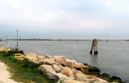
The Chulyshman Valley is a real canyon with a width of up to several kilometers in places and a depth of more than 500 meters, and a length of 135 km with a hook. This canyon extends from the very upper reaches of the river - Lake Dzhulukul to its confluence with the southern end of Lake Teletskoye. The river is one of the largest in the Altai Mountains and about 70% of the water in Teletskoye is Chulyshman water. The length of the river is about 240 km. It begins on the Chulyshman Highlands, on which there are more than 300 lakes + considerable areas of swamps. From a height of approximately 2200 meters, the Chulyshman, merging with small tributaries, flows from the marshy area into the mountain gorge. Here the river takes on a strong mountain character: high flow speed and many complex and dangerous rapids, waterfalls and riffles. The upper reaches of Chulyshman are generally uninhabited, and have never been inhabited by people. Some modern, some ancient. In the middle reaches of the river, the first sign of human presence clings to life - the village of Yazula. He also has the only road bridge across Chulyshman. From this same place, routes for experienced water tourists begin.
The river from this section becomes very powerful and with big amount really challenging rapids. In the Yazuly area, a 15-kilometer section of the canyon is a continuous, extremely dangerous Yazulinsky threshold. The rocks are pressed so closely to Chulyshman that there are places that are impassable even on foot.
About 20 km further downstream and now it is probably already known to everyone who was interested in Altai - the Katu-Yaryk pass. In this part, along Chulyshman there is a quite tolerable road connecting the villages of Koo and Balykcha through the pass with Ulagan. Every year more and more people appear on the banks of Chulyshman tourist centers, and indeed this is the most populated part along the river.
When mentioning the Chulyshman Valley, many mean precisely this, the most civilized part of the canyon. It is inhabited by the Orthodox Telengit tribe, dating back to the 19th century. The people, quite recently, were still very, very conflict-ridden, and generally warlike, like the Altai highlanders. But even now it’s quite possible to get into trouble out of the blue or even catch a charge of buckshot in a car chandelier turned on at night (locals really don’t like to catch such illumination in their eyes on a narrow winding mountain road with a cliff along the edge into the abyss of a river).
There are many waterfalls along the banks, relatively large and very small. It was here, on the Chulcha River - the right tributary of Chulyshman, that the large cascading waterfall Uchar (translated from Turkic means “Unapproachable”, another name is “Flying”) - 160 meters is located. It was he who was the final goal of our trip this May. The waterfall also has a very toponymic name - “Big Chulchinsky Waterfall”.
Google sees Uchar like this. The Chulcha River flows from right to left. Literally a few kilometers to the right and there are already Khakassia and Tuva. To the left at 12 km there will be Chulyshman and the base where we stopped.
The waterfall was formed only about two hundred years ago as a result of a strong collapse caused by another Altai earthquake, and was discovered only in the seventies of the 20th century, well tourist site is probably a little over ten years old. Here is the exchange over two centuries: Maashei disappeared, but Uchar arose.
So, how did we get there? And we got there without any problems, except for one. A week or two before the trip, I called one of the bases called “Stone Mushrooms,” which is located exactly opposite these same mushrooms. Everyone rank by rank, ordered an ail, agreed on a price. Three days before the trip, the base called us and we confirmed the date and time of arrival. However, on the day of arrival, at ten o’clock in the evening, when we drove up to this base, we were stunned by the news - “oh, you know, some people arrived here, well, we settled them... But don’t be upset, right now we’ll We’ll quickly scatter them among the summer houses, and tomorrow we’ll move everyone together in the village.” It’s great, 5 people, three of whom are children, are scattered in houses... That is. all these dances with reservations, in fact, are not for the convenience of vacationers, but to guarantee the earnings of the “basers”, who, in any case favorable from their point of view, will forget about your reservation, and you can drive 1000 km and approach the base to hear - “oh, sorry, but there are no places...”, and the dark night sets in around us and the pristine nature roars (we even once heard the song of wolves in that area early in the morning). This is such an anti-advertising of the "Stone Mushrooms" base that you can easily forgive yourself for booking for a family of 5 people.
Not wanting to “spread out into summer houses” or pull out the “emergency tent” from the trunk, we drove into the night to look for a place at other bases. The one next to us is polite. but they clearly said that there are no free or unreserved seats and, in general, everything is strictly according to reservations, so excuse me. How nice it is to hear and see such fundamental care for clients, in our case!)) Even through the base, we still found an unoccupied village and settled in at the Ust-Chulcha base.
The first day turned out to be cloudy, but as always on Chulyshman, very warm. This is the unique climate in the valley.
We spent this day in blissful idleness and respite from the road. We wandered around the base a little, took a picture of the watchdog and the sunset, for good measure.
Snow clouds are wandering along the horizon, dark night shadows are already crawling along the nearest slopes, but nevertheless the sun periodically breaks through this haze and leaves such red stripes on the mountains.
On the morning of the second day we geared up to the Uchar waterfall. And the day of our hike was already filled with bright spring sun and real heat. Joy to everyone, except for our husky, boiling in the sun.
Crossing is only by boat. The ride takes 2 minutes, and the price tag is 500 rubles. for /here-there/.
The Chulcha River on the road to Uchar. It sounds implausible, but kayakers and even, they say, catamarans raft along the Chulcha. only for them you have to do a lot of carrying around - not so much floating as dragging.
Our youngest traveler is 6 years old and is already a seasoned tourist, for he began his tourist feat at the age of 4 by climbing the large Ak-Tru glacier. Therefore, we were worried about only one place on the route - crossing the railings. We learned from oncoming travelers that 2 of the four railing fastenings were torn off and therefore they themselves sagged. But this is not a problem for the boy. Problem with the dog. How to drag it?
13 minutes video of our hike to Uchar.
Returning from Uchar along the Chulchi gorge. Ahead is the Chulyshman Valley.
It’s spring, cranes have arrived from warm countries. Two couples hung around the area constantly. They fly and curl. Not a Siberian Crane, of course, but still beautiful.
He left his family and attacked one. The dog tried to run after me, was scolded and returned to the pack. While I was climbing back and forth, I stood motionless and watched.
Uchar Waterfall, also known as the Big Chulchinsky Waterfall, also known as the Impregnable Waterfall, or the Flying Waterfall.
Uchar made no more impression on me than the same Korbu. Yes, the cascade is really huge, but somehow there is no feeling of excess, chthonic natural force. Looks like the result of blasting)
Not far away, on the right bank of the Chulyshman, in the Ak-Kurum tract, in the Karasu gorge, probably unique rock formations “grew” - stone mushrooms. The mushrooms were formed from blocks of hard rock on top of the formation, which now represent a kind of umbrella for the soft rock stalk. Over the years, the softer rocks under the stones are eroded by precipitation, thereby forming a mushroom stalk. In the gorge there are two “myceliums”: “adult” and “young” mushrooms. The first reach a height of about five meters, the second 1 - 2 meters. Both continue to grow, and periodically fall during earthquakes. If you touch the leg of the mushroom, you can feel the roughness of the surface and small pebbles protrude along its entire perimeter (“cement” made from clays and crushed stone, in fact). Mushroom caps are made of durable rocks, have an impressive size, and are smoother to the touch.
Photo from three years ago, when we went to Mushrooms.
Local luminaries in geology claim that in half a century there will be no trace of mushrooms left, because... they will be destroyed by erosion. To tell the truth, we saw such mushrooms, only smaller ones, in the valley of the Chulchi River, which runs parallel to the tract with the advertised Mushrooms.
Local luminaries, only not of geology, but of mystical beliefs, claim that as soon as the last hat flops, the End of the World will certainly begin here... The UN must quickly reverse its close attention and strengthen the caps, otherwise the whole world will fall apart because of Altai mushrooms...
A view from the Katu-Yaryk pass to the Chulyshman valley.
Just a two-hour drive from our warm camp on Chulyshman and we go from summer to winter. Ulagansky (or maybe nameless) pass at an altitude of 2080 meters. The lakes around are under ice, snow has fallen, and May 9 is on the calendar.
At the pass itself. The dog decided to run through the snow and fell headlong. Got out by jumping on his hind legs)
Already returning home, on the way back at the confluence of Chuya and
The Katuns decided to explore the old road that runs along the left bank of the Katun at the confluence of these two rivers.
First, we took pictures against the backdrop of the road that was carved into the rock, and only then we drove along it. Just a few years ago, driving through this section was inevitable on the way to Belukha. There is another, simpler, but much longer path, on the other side, entering from the Kazakh border.
We should tell you about our short trip to the Uchar waterfall. This is a very unique and inaccessible attraction of the Altai Mountains, located on the Chulcha River. Well, or almost inaccessible, since we’ve already been there. The three of us rode to the mouth of the Chulcha on a Ural motorcycle in the first days of August 1917. The boatman of the camp site ferried us across the Chulyshman River and waved his hand: “Go there.”
Our journey began from Altai. Through Aya we went to the Chuisky tract, an excellent federal road running through Mountain Altai to Mongolia. During the holiday season, the highway is full of frantic motor tourists flying into the distance, although the road is narrow in places and winds steeply between mountain spurs. Our motorcycle with three tourists, a backpack of canned food and a can of gasoline can barely drag itself. However, if you drive faster, it gets cold.

In the morning we were followed for a long time by a large dark cloud. By evening, on the contrary, they themselves inevitably caught up with a powerful thunderstorm, which turned out to be faster and went away. In Aktash after the rain it was damp and cold, and all the camp sites were occupied. While we stocked up on gasoline long way to the mountains, where there are no gas stations, while we were looking for an inexpensive place to stay for the night, night fell. I had to climb in the dark through the Red Gate past Dead Lake to the Ulagansky pass. There, at his camp site, the well-known Mikhalych greeted us very good-naturedly. Hot tea, a hot sauna, a roof over your head and a cool museum turned out to be very helpful.

The delightful nature along the Chuysky tract will not leave you indifferent. Even an ordinary trip along it turns out to be so exciting that it draws you further and further into the depths. Throughout its entire length, the landscapes are constantly changing: first there were mountains overgrown with forest, then they became almost bare, chaotically composed of boulders, suddenly they grew into high cliffs with huge boulders scattered around. Well, if you know where to turn off the highway, you can find such stunning sights that you will regret not deciding to go earlier.

On the second day, at the approach to the Katu-Yaryk pass, a huge cloud suddenly emerged from behind the mountains. Maybe we climbed so high that we walked right into it. Squally wind, heavy rain, hail - everything was mixed up. The cafe-village in which they managed to hide could barely withstand the blows of fate. After waiting out the bad weather, we went down to Chulyshman and slowly drove along a narrow road into the gorge to the Ust-Chulcha camp site. As soon as we settled down in the village, a powerful thunderstorm struck again: the wind rocked the buildings, wanting to tear them out of their places, the hail seemed to hit the roofs like hammers, water flooded everything around, and thunder shook all living things. Then the thunderstorm passed, leaving great doubts about the possibility of tomorrow's hike, and night fell.

However, the next morning the weather turned out to be excellent. There were no traces left of yesterday's disaster, as if nothing had happened. On this sunny day we reached the waterfall, saw and heard it, looked at it for a long time and admired it. We returned to the camp site only in the evening, tired but happy. On the path to the waterfall we met many tourists from all over our country, of different ages, some alone, some in groups. Some tourists came not for the first time. Despite its inaccessibility, the Uchar waterfall is becoming quite popular.

The hiking trail to the Uchar waterfall leads along the slope of a rather deep gorge above the steep bank of the fast-moving Chulchi River. This is a tributary of Chulyshman, the main river flowing into Lake Teletskoye. Actually, the Chulcha River flows through the territory of the closed Altai Nature Reserve, but an inexpensive paid passage is open to the Uchar waterfall. The length of the trail is short, about eight kilometers in one direction. But for some tourists, the narrow path simply exhausts them. It goes up and down; sometimes it leads along a ridge, sometimes it makes its way through the bushes; only occasionally diving into the thickets of trees growing along the streams flowing small waterfalls along the steep slopes of the gorge. The water in them on a hot summer day seems very tasty and invigorating, giving strength to climb further along the iron brackets driven into the rocks.


Uchar waterfall has quite greater height– 160 meters, but it is hidden behind many of its cascades. They say that not so long ago, about two hundred years ago, a mountain collapse occurred, the debris of which blocked the bed of the Chulchi River, but it overcame the dam of huge boulders like a waterfall and rushed about its business. And the place where the mountain broke off is still visible.

Many people want to see this incredible miracle nature, like Uchar, and we also wanted to visit there. However, the reality is many times greater than the expectations of the unusual. The huge boulders of the Chulchinsky waterfall, the endless streams of water flowing down them, and the accompanying fog and roar, evoke incredible human delight. Although in August it is low in water, the waterfall simply mesmerizes its guests!

We stopped for the night at the Ust-Chulcha camp site, which is located on the left bank of the Chulyshman River, opposite the mouth of the Chulcha. The valley of the Chulyshman River is a fairly large and deep gorge, which can be reached by ferry, crossing Lake Teletskoye along its entire length, or along a gravel road through the Katu-Yaryk pass. At the site of the pass, the depth of the gorge is about eight hundred meters and Katu-Yaryk is simply a descent to the Chulyshman River. To the Katu-Yaryk pass the road goes through the villages of Ulagan and Balyktuyul from the village of Aktash. On the hundred kilometers of mountain road along the Ulagansky plateau, only in places there is asphalt, otherwise it is just a dusty gravel washboard. It’s good that you can get to Aktash along the Chuysky tract.

The morning of the fourth day was cloudy. We had to get ready to go home, so we stuffed our things into the motorcycle and set off on the way back. Local road on the Ulagansky plateau, most of it is broken gravel and cannot be driven quickly along it. I had to drag along in the Urals all day in first or second gear. At the Ulagan Pass, at the entrance to Lake Kidel, it started to rain again, but we managed to hide in a cafe-aul near the lake. Altai food there turned out to be very tasty! The day before we reached the camp site in Bely Bom and spent the night there. By the evening of the fifth day, the travelers reached home.
On the way back we managed to look at the old road to Inegen. It is carved right into the rock above the Katun River. This is part of the Inya - Tungur trail, which is held in high esteem among extreme motorcycle enduro enthusiasts.

I’ll tell you again how to get to the waterfall by car. Along the Chuisky tract you reach the village of Aktash. Along the Ulagansky tract you get to the Katu-Yaryk pass. You go down and go to any tourist center opposite Chulchi, there are several of them. In the morning you swim to the other side and go to the waterfall. And here it is: the unusually magical miracle of Chulchi. Eye-catching!

Do you want to see this miracle? Please look! The unique Uchar waterfall is simply worth visiting, and more than once! In addition, the Stone Mushrooms are very close by, South coast Lake Teletskoye and many other attractions of the Altai Mountains.