Sutoloka River - Ufa from A to Z. Along the bed of the Sutoloka River, Sutoloka from the source to the mouth So, the main question is where are the sources
Sutoloka, a river flowing through the southern part of Ufa, dividing the city into two parts by the deep Sutolotsky ravine. Several decades ago, the river had a length of just over 8 km, a winding bed 1.5–5 m wide and less than 1 m deep. city ravines.
Despite the fact that the river had little water, it had a wide ancient valley, reaching a width of three kilometers in the lower reaches. Seventeen streets went down to the right bank of the Sutoloka, and seven streets went down to the left. Along the banks of Sutoloka there were five suburban villages - Glumilino, Dubovka and three Novikovka.
Until the early 1970s. in the Sutoloki valley there was Pivzavodskoye Lake with a mirror area of 100x80 m. Later it turned into a swamp and dried up. Half a kilometer from Botanical Garden in the riverbed there was a ledge one and a half meters high with a waterfall. Below the waterfall, the riverbed turned into a valley resembling a ravine. The depth of the incision downstream increased, reaching 13 m at the bridge. The channel had a steep slope, on average 12 m per 1 km, in the lower reaches - 28 m per 1 km, so the rise of water in the river. Belaya during the spring flood spreads from the mouth of Sutoloka to no more than 300–500 m.
Sutoloka divides the southern part of the city into two parts by a deep, wide ravine, and therefore understanding what Ufa is is impossible without recognizing what Sutoloka is. This was well understood before. A description of Ufa at the end of the 18th century, made by a military topographer, has been preserved:
“This city lies between eight great and deep gullies (ravines). - S.S.), of which in one, which runs across the city, the river flows. Bustling, and surrounded by high mountains.”
“The bustle divides the city into two uneven parts: the old – smaller part and the new – larger part,” pointed out M. Somov (“Description of Ufa”, 1864). - Old Ufa, which lies on the left side of Sutolka, has still retained the entire physiognomy of ancient Ufa: it has narrow, irregular streets, small wooden houses, with the inhabitants mostly from the poor class of townspeople and peasants.
The new part, located on the right hand of Sutolka, differs from the first in its more regular location and significant width of streets, the abundance of stone and better wooden houses and the concentration of all almost public and government buildings and most of the churches. Both parts are connected by a stone bridge of simple construction running across Sutolka.”
Geographers call the landscape of the south-eastern part of the city between the Ufa River and the Sutoloki Valley, occupying the interfluve ridge with the Lysa (Dudkinskaya) and Usolskaya mountains, as well as the Sergievsky Hill, the Ufa-Sutoloki landscape. The areas of the plateau located between them are gradually being leveled as a result of urban development, but this is hampered by ravines stretching towards the valleys of the Belaya, Ufa and Sutoloka rivers.
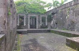
Mouth of the Sutoloki River. Archive photo
The southwestern part of the Belsko-Ufa interfluve west of the Sutoloki valley is covered by the so-called Belsko-Sutoloki landscape. Its western and southern outskirts are dissected by deep ravines, the hills drop steeply to the Belaya River. The rest of the plateau is lowered and smoothed, most of it was built up before the revolution. Here are the city's key streets and squares - Lenin, Pushkin, Kommunisticheskaya, Sovetskaya Square, the southern part of Oktyabrya Avenue.
Several decades ago, the Sutoloka had a length of just over 8 km, a winding bed from 1.5 to 5 m wide and a depth of about 1 m. themselves with runoff from urban ravines.
The stories of some Ufa residents about how, before the revolution, “ships sailed under sail” along the Sutoloka are fables, absolute fantasy! “In ordinary times, it does not deserve the name of a river,” wrote M. Somov, “it is nothing more than an insignificant stream. It is also remarkable that in the month of May 1824, huge mammoth tusks were found on its banks, near the place where the Cossack Gorbunov’s mill used to be; but where they went is unknown.”

Bridges over the Sutoloka River. Photo from the 1910s.

The townspeople living next door said ironically, “This is the Sutoloka River, don’t joke with it, you can’t jump from one bank to the other without a running start.” There was a belief that in the spring, on the twelfth day after “The Turmoil begins to play,” Belaya begins to move; but it is unknown whether anyone checked this sign.
The depth of the incision downstream increased sharply, reaching 13 m at the bridge. The channel had a steep slope, on average 12 m per 1 km, in the lower reaches - 28 m per 1 km, so the rise of water in the Belaya River during the spring flood spread from the mouth The commotion is no more than 300–500 m.

Sutoloka River. Photo from the 1910s.
Let's think about the name of the river. It has developed historically and has several interpretations. The original version, recorded in documents of the 16th century. – Sukoloka – has Finno-Ugric origin “su” water, “koloka” or “kolka” – pound, knead, literally “pound water” has analogues in Turkic languages. According to M. Somov, the river received its name “from its fast flow in the spring; the word Turmoil was made up of two Nogai-Tatar words: su - water and tilak - mad.”
According to another version, the name is associated with the willow growing along the banks of the river: “su” - water, “talyk” - willow. Russian people changed the name into a more understandable one - “Sutoloka” (sometimes “Sutolka”). The city river gave its name to the literary almanac “Sutoloka”, which was published in the 1990s; the subtext is “the hustle and bustle of life.”
It is better to take a walk-exploration of Sutoloka during the spring melting of snow or at the very beginning of June, when its bed at least vaguely resembles a river or a large stream. Another recommendation - hurry up to take this walk, because the Bustle, like a river, disappears before your eyes - everything most of its bed at various sections goes into concrete pipes, it is possible that soon almost the entire city river will turn into an underground drain.
So, the main question is where are the origins?
The author of the book knows them from childhood memories of excursions around the city in the mid-1970s, which were led by two geographers, two teachers of the geography department of Bashkir State University, Ivan Prokofievich and Elizaveta Ilyinichna Kadilnikov. These were walks to the Hanging Stone and Lake Sipailovskoye, to rocky outcrops in the area of the Sports Palace and to the area of the Forestry Technical College, where a picturesque forest park and radio towers were located.
At that time, there was no need to guess the origins of the Sutoloki River - it began in a shallow, swampy ravine near the territory of the Forestry College (an area just above the modern automobile interchange on Lesotechnikum Street).

After the construction of a transport highway along the bottom of the Sutolotsky ravine, the landscape changed significantly. Now the Sutoloka River originates from a spruce forest under the hill on which the Nur Theater stands, and it flows out of a concrete pipe. Photo by Sergei Sinenko
Few people know the old name of the area in the upper reaches of Sutoloka - Turovo Field. In the refusal letters of the late 16th – early 17th centuries. it was also called the “battle steppe” (“battlefield”).
The name is associated with the founding of the city of Ufa and the direction for its defense in 1584–1586. to the Bashkir region from the Volga region cities of service people under the leadership of F. Turov and Z. Volokhov. Near the sources of the Sutoloka River on the Turov Field, a military clash took place between Russian troops and the advanced units of the army of the Siberian princes Ablai and Tevkel, who were then finally defeated in the Ablai forest beyond the Ufa River.
The bed of Sutoloka disappeared along with the upper part of the ravine under the asphalt pavement of Lesotekhnikum street, and the ravine, divided into gardens and vegetable gardens with miniature garden booths, until recently stretched to the southwest, where it was crossed first by a bridge, and then by a high embankment, through which On the side of Oktyabrya Avenue there was Poltavskaya Street, renamed in 1972 to 50 Years of the USSR Street. This embankment disappeared along with the construction of a large road bridge across the ravine.

Fragment of a map from 1939, which shows the sources of the Sutoloki River, the Silkwater Station, the Botanical Garden and Pivzavodskoye Lake
In 2003–2004 collective gardens were demolished, the ravine was deepened, and a new one stretched along its bottom highway, and a road bridge was also erected on the line of the Lesotekhnikum street. So the current sources of Sutoloka and, in general, what this river has become now, after the construction of the highway, will have to be carefully studied.
Salavat Yulaev Avenue, a large transport highway connecting the “southern gate” of Ufa with the residential area of Sipailovo and the industrial area of Inors, currently runs along the main part of the Sutolotsky ravine. The length of the new highway from the road bridge over Belaya to the road junction at the intersection with Mendeleev Street is 7 km. The width of the carriageway of the avenue is 26.5 m (six lanes of the roadway with a six-meter dividing strip), plus four-meter acceleration sectors in front of the bridges.
On the section of the route from Lesotekhnikum Street to the junction on 50 Let USSR Street, where the Sutolotsky Ravine begins, there is not even a trace of the Sutoloka River - here it has completely disappeared into the underground sewer drains.
Of the buildings in the district, the building of the Ufa State Tatar Theater “Hyp” (50 Let USSR Street, 36) stands out. Not far from the Nur Theater, on the eastern side of Salavat Yulaev Avenue, the Sutoloka River currently originates - it is almost one and a half kilometers below its original source. The water in the river has a distinct soapy smell; it smells like sewage. The highway here runs along a dam, which Sutoloka is constantly washing away; these screes come close to the highway.
Further on, the river flows along the border of the forested park area, sometimes very close to the highway, sometimes retreating from it by 10-50 m. On the western side of Salavat Yulaev Avenue there is a large garage cooperative in a ravine on Visherskaya Street. Previously, a tributary flowed into Sutoloka from this ravine.
Visherskaya Street itself, which today runs from Komsomolskaya Street towards Salavat Yulaev Avenue, and is limited on the southern side by a ravine, arose in the 1920s. and initially stretched from the Sutoloka River to the west all the way to the airfield in the area of the current R. Sorge Street, crossing modern October Avenue and further along the line of Brothers Kadomtsev Street (this street was also called Visherskaya).
Currently, the street has been reduced in length by three to four times, is built up with private houses, and its lower part is completely absorbed by a garage cooperative.
Let's move on. Behind the ravine from the Visherskaya side begins a picturesque forest park, where for many years there was the clinic No. 1 of the Council of Ministers of the BASSR, and today - the children's psychoneurology center and the Republican Clinical Hospital No. 2. Here is Visherskaya Malaya Street. On the southern side, the hospital territory is separated from the residential area by a long swampy ravine - previously another right tributary flowed through it into Sutoloka.
Immediately beyond the ravine, along it, from the buildings of the Ufa Motor Transport College to the highway, three streets with similar names stretch - Malaya, Srednyaya and Bolshaya Shelkovodnaya - the former territory of the village of Novikovka. Shelkovodnaya Station Street is also located here. On the map of 1939, the Ufa silkworm station is indicated in this place, where silkworms were bred - it was this station that gave the name to several streets.
Below the Sutolotsky ravine there is a third automobile interchange, which, according to the designers, through the tunnel being built here will connect the street of the City of Halle with Zaufimye through a new bridge. In 2002, in connection with the construction of a tunnel, part of the Sutoloka riverbed in the area of the foresters' park was removed into a reinforced concrete pipe.
The tunnel towards Ufimka has been under construction for more than fifteen years, but this important object for the city has become a “long-term construction” for objective reasons - due to difficult karst soils. There is constant movement in the ground next to the tunnel under construction. The question of the feasibility of the construction was discussed more than once, there were proposals to abandon it, but when they calculated the expenses already incurred, they came to the conclusion that it would be more expensive to mothball the construction than to complete it.
From here you can clearly see the wide ancient river valley, reaching a width of three kilometers in the lower reaches. From above, the significance that the small river has for the city becomes clearer - although Sutoloka has always had little water, it shaped the local landscape.
Until recently, the Sutoloki Valley was characterized by an abundance of ravines, hollows, streams, swamps, meadows and wild thickets. There were large karst sinkholes here, and there were large sinkholes - most of them are filled in today, but traces of them are easy to find.
The slopes were dominated by one-story houses with bathhouses, vegetable gardens and orchards. Seventeen streets used to go down to the right bank of Sutoloka, and seven streets went down to the left bank. The bustle divided the southern part of the city into the central western part and the outlying eastern part, which, with the exception of the Usolskaya and Sergievskaya mountains, until the last third of the 20th century. It was a forested area where sanatoriums, rest houses, pioneer camps and village-type settlements with vegetable gardens and orchards were located.
There were five suburban villages along the banks: Glumilino and Dubovka on the right bank of Sutoloka in its northern part and three villages of Novikovka in the middle reaches of the river in the territory of present-day Ufa in the area of Sagita Agisha Street.
Novikovka today is the name given to a large microdistrict that arose on the eastern side of the Sutolotsky ravine in the 1970s–1980s. On pre-revolutionary maps, all this is “the land of the landowner Novikov” - ancient family estate Novikov nobles, who left a noticeable mark on Ufa history. The most famous is Valentin Apollonovich Novikov (1837–1880), local historian, author of a large study on the history of the Ufa nobility, works on statistics and economics of the region.
During his lifetime, V. A. Novikov became popular as the organizer of a shelter for pupils of the Mariinsk Women's Gymnasium, as a peace mediator for the Ufa district, one of the first to introduce the Regulations on February 19, 1861 on the abolition of serfdom. The two-story country house of V. A. Novikov stood on the site of the current BashEXPO exhibition center.
At the beginning of the 20th century, in addition to the village of Bolshaya Novikovka, famous for its apple orchards, there were two more villages nearby - Novikovka Malaya 1st and Novikovka Malaya 2nd. All the villages were located on the slope of the Sutolotsky ravine: Bolshaya Novikovka - on the left bank of the Sutoloka River, the other two - on the right.
According to local historian Z. Gudkova, in 1920 the villages became part of the city and were renamed. The three villages of Novikovka were to be named after Mikhail Kalinin, Krestyanskaya Malaya 1st and Krestyanskaya Malaya 2nd. But the names did not take root, and the villages themselves gradually dissolved into urban development.
In 1938, it was decided to liquidate the villages and rename them streets. This is how the Polar, Bolshaya Shelkovodnaya and Northern arose. The names of these Ufa streets are well known to Ufa residents.

Quite a rural landscape. On Brestskaya street.Photo by Sergei Sinenko

Until the early 1970s. in the Sutoloka valley below Bolshaya Novikovka there was Pivzavodskoye Lake with a surface area of 100x80 m. Later it turned into a swamp and dried up. Half a kilometer from the Botanical Garden in the river bed there was a one and a half meter high ledge with a waterfall. Beyond the waterfall, the riverbed turned into a valley resembling a ravine.
Twenty years ago, in addition to residential areas, in this area there were many rest houses and pioneer camps (Vodnik, Zvezdochka, TRZ, etc.), collective gardens and vegetable gardens. Along the eastern edge of the ridge, along a steep slope, rich broad-leaved forests are still preserved, among which the Green Grove sanatorium is located.
As a result of the construction of a highway along the bottom of the Sutolovochny Ravine, the landscape completely changed, acquiring ordered urban features, while losing the charm of the old patriarchal part of the city.

Some neighborhoods along the banks of Sutoloka still have a rustic appearance - bathhouses, chicken coops, sheds, and vegetable gardens. On Sun Yat Sen Street. Photo by Sergei Sinenko
Downstream, the Sutoloki Valley continues to expand. The river either dives into concrete pipes, then reappears on the surface - this happens several times. At the line of Aiskaya Sutoloka Street and Salavat Yulaev Avenue they are finally separated. From Krasnoyarskaya Street, Prospekt goes in a straight line to the road bridge, and the river flows along a deep ravine along Brestskaya Street to the dam through which it passes tram line and Sun Yat-Sen Street (this is how the name of the street is written in Ufa when talking about the Chinese revolutionary Sun Yat-sen).
Let's go up the dam. Around are the ancient streets of Ufa Posad. The original name of Sun Yat-Sen Street was Kopeikin Street, or Captain Kopeikin Street. Moskovskaya Street, Bolshaya Street and Malaya Street, in Old Ufa, run along the western slope of the ravine. Bolshaya Moskovskaya Street begins in the Sutoloki ravine, then goes east along the right branch of the ravine. Malaya Moskovskaya Street runs further south, closer to Mendeleev Street.
These are the streets that are marked on all old maps of the city. Their emergence is associated with the appearance in Ufa in 1698 in the northeast of the Ufa Kremlin along Siberian road Moscow Sloboda.
The settlement received its name in connection with its settlement by disgraced Streltsy, exiled to Ufa for participating in the famous Streltsy revolt against Peter I, who ordered the Moscow regiments to be disbanded, the Streltsy, along with their families, to be sent to distant cities and there registered as “posad people” - artisans and traders .
Ufa became one of the places of exile for the archers. The disgraced archers were assigned to live north of Sergievskaya Gora in the area of what is now Bolshaya and Malaya Moskovskaya streets. Two Moscow lanes were also formed here. In Soviet times, the first Moskovsky lane was renamed Kashirina Street (it is unclear in honor of which of the Kashirin brothers), then Ukrainian, and finally Yamalskaya. Second Moskovsky Lane was first renamed Blyukhera Street, then became Sutolochnaya Street (its traces can no longer be found today).
Posadskaya Street stretches along the eastern edge of the Sutolovochny ravine. It arose with the appearance of the settlement next to the Kremlin and has not changed its name since its inception. Posad, as part of the city along the bank of Sutoloka, appeared here at the end of the 16th century; posad people began to settle in the 17th century.
Significant growth of the settlement occurred in the 18th century: in the 1750s. The number of residents of the settlement reached 180 people, among them the merchant elite stood out - local representatives of the capital's merchants, the so-called guests and trading people of the living room of the hundred. Later, the owners of the Ural factories Tverdyshev, Myasnikov, Osokin, and the famous factory owners Demidovs built their own estates or bought houses on Posadskaya Street.
The future of the oldest Ufa street is uncertain, although there were projects to turn it into a memorial zone or construction on the landscaped bank of Sutoloka Boulevard “Posadsky”.
The most significant building on the street is the Church of the Intercession of the Mother of God (belongs to Mingazheva Street, 4).
The bustle on the last stretch winds a little, but its bed goes in the same direction as Posadskaya Street. Being a right tributary of the Belaya River, it flows into it at Pervomaiskaya Square. Here, along the river, in its lower part, is Sutolovnaya Street. We are moving towards the embankment along a vast wasteland, currently undeveloped. The changes are amazing!
Until recently, the river bed passed here, and closer to the mouth for centuries, changing shape and design, stood the Sutolotsky Bridge. The first bridge over Sutoloka, and in general the first city bridge, was built here shortly after the construction of the Ufa Fortress for moving to Sergievskaya Mountain. It was made of wood and was repaired many times without changing its location.
At the end of the 1930s. A wider reinforced concrete bridge with a brick parapet, adapted for the movement of vehicles of any carrying capacity, was built on this site. In 1957, a new bridge was built in the same place, which served until recently. In 2006, the river was enclosed in a new channel - a reinforced concrete rectangular collector 300 m long, which stretched from the mouth of the river to the old pumping station, which housed baths and saunas (Posadskaya St., 12). The former riverbed in this section was covered with soil up to the level of the bridge, and at the intersection of five streets - Pugachev, Sochinskaya, Mendeleev, Posadskaya and Oktyabrskaya Revolyutsii - a flat area appeared.
A large transport interchange has been created on it, forming in its upper plane a transport ring with a diameter of about 40 m, as in the Central Market Square. In the future, it is planned to make this interchange two-level. For pedestrians, there is a transition in three directions: to the embankment, to the bus stop and to the granite staircase of the Friendship Monument. The embankment itself did not go unnoticed. Due to the filled-in riverbed, the pier was lengthened.

Losing its food sources, today the river has actually turned into a shallow stream. The water in it, of course, has become cleaner, but, disappearing into concrete drains, the river disappears, loses its essence, turns into one of the sewer drains, repeating the fate of another small river that once flowed through the city center, Nogaika. Photo by Sergei Sinenko
2017-12-18T22:42:13+05:00 Blog of Sergei Sinenko Ufa from A to Z city, history, local history, river, Old UfaThe Sutoloka River in its lower reaches. Photo by Sergei SinenkoSutoloka river - Ufa from A to Z Sutoloka, a river flowing through the southern part of Ufa, dividing the city into two parts by the deep Sutolotsky ravine. A few decades ago, the river had a length of just over 8 km, a winding channel 1.5–5 m wide and a depth of less than 1 m. View...Ufa from A to Z City Encyclopedia Ufa from A to Z Urban Encyclopedia[email protected] Author In the Middle of RussiaPlaka is such a basic area of Athens, a kind of center of local authenticity and at the same time an attractive place for tourists. Plaka is located at the foot of the Acropolis, accordingly being, by definition, the oldest district of the city. An interesting point is that many buildings were built on foundations dating back to ancient times. And in a nutshell, Plaka can perhaps be compared to Moscow’s Arbat.
1. The first thing that catches your eye is the abundance of church utensils sold here and there. Considering the special piety of the Greeks, this is logical, but at first it is surprising. 
2.
3. It was nice to meet my native brand. 
4. There are also places of pilgrimage for fur tourists nearby. In fairness, I note that the local Russian-speaking “guides” immediately tried to take into account the absent-minded me and “fantastically favorable conditions"steam fur products. 
5.
6.
7.
8. Just look a little deeper and you can see real life. 
9. And, turning back, you again see a sea of souvenirs. 
10. I really didn’t expect to see that. IN Lately you see them less and less often, and not only in Russia, but also in other countries. 
11.
12. Smiling at the morning newspaper. 
13.
14.
15.
16. Dogs lie literally under your feet. It's a miracle you manage not to step on it. 
17.
18.
19.
20. Either a Chinese Greek, or a Greek Chinese. 
21.
22. “So, first straight to the end, then right.” In fact, it’s easy to get lost in the intricacies of Plaka’s streets. 
23.
24. 
25.
26. Hadrian's Arch is visible nearby. 
27. Monument to Lysicrates. In general, there are a lot of ancient islands here, as it seemed to me. 
28.
29.
30. Well, one last lantern. 
Sutoloka River from source to mouth
Sergey Sinenko
Sutoloka divides the southern part of the city into two parts by a deep, wide ravine, and therefore understanding what Ufa is is impossible without recognizing what Sutoloka is. This was well understood before. A description of Ufa at the end of the 18th century, made by a military topographer, has been preserved: “This city lies between eight great and deep gullies (ravines). - S.S.), of which in one, which runs across the city, the river flows. Bustling, and surrounded by high mountains.”

Mouth of the Sutoloki River. Archive photo
“The bustle divides the city into two uneven parts: the old – smaller part and the new – larger part,” pointed out M. Somov (“Description of Ufa”, 1864). -, lying on the left side of Sutolka, has still retained the whole physiognomy of ancient Ufa: it has narrow, irregular streets, small wooden houses, with the inhabitants mostly from the poor class of townspeople and peasants.
The new part, located on the right hand of Sutolka, differs from the first in its more regular location and significant width of streets, the abundance of stone and better wooden houses and the concentration of all almost public and government buildings and most of the churches. Both parts are connected by a stone bridge of simple construction running across Sutolka.”
Geographers call the landscape of the south-eastern part of the city between the Ufa River and the Sutoloki Valley, occupying the interfluve ridge with mountains, as well as the Ufa-Sutoloki landscape. The areas of the plateau located between them are gradually being leveled as a result of urban development, but this is hampered by ravines stretching towards the valleys of the Belaya, Ufa and Sutoloka rivers.

Bridges over the Sutoloka River. Photo from the 1910s.

The southwestern part of the Belsko-Ufa interfluve west of the Sutoloki valley is covered by the so-called Belsko-Sutoloki landscape. Its western and southern outskirts are dissected by deep ravines, the hills drop steeply to the Belaya River. The rest of the plateau is lowered and smoothed, most of it was built up before the revolution. Here are the city's key streets and squares - Lenin, Pushkin, Kommunisticheskaya, Sovetskaya Square, the southern part of Oktyabrya Avenue.
Several decades ago, the Sutoloka had a length of just over 8 km, a winding bed from 1.5 to 5 m wide and a depth of about 1 m. themselves with runoff from urban ravines.
The stories of some Ufa residents about how, before the revolution, “ships sailed under sail” along the Sutoloka are fables, absolute fantasy! “In ordinary times, it does not deserve the name of a river,” wrote M. Somov, “it is nothing more than an insignificant stream. It is also remarkable that in the month of May 1824, huge mammoth tusks were found on its banks, near the place where the Cossack Gorbunov’s mill used to be; but where they went is unknown.”
The townspeople living next door said ironically, “This is the Sutoloka River, don’t joke with it, you can’t jump from one bank to the other without a running start.” There was a belief that in the spring, on the twelfth day after “The Turmoil begins to play,” Belaya begins to move; but it is unknown whether anyone checked this sign.
The depth of the incision downstream increased sharply, reaching 13 m at the bridge. The channel had a steep slope, on average 12 m per 1 km, in the lower reaches - 28 m per 1 km, so the rise of water in the Belaya River during the spring flood spread from the mouth The commotion is no more than 300–500 m.

Sutoloka River. Photo from the 1910s.
Let's think about the name of the river. It has developed historically and has several interpretations. The original version, recorded in documents of the 16th century. – Sukoloka – has Finno-Ugric origin “su” water, “koloka” or “kolka” – pound, knead, literally “pound water” has analogues in Turkic languages. According to M. Somov, the river received its name “from its fast flow in the spring; the word Turmoil was made up of two Nogai-Tatar words: su - water and tilak - mad.” According to another version, the name is associated with the willow growing along the banks of the river: “su” - water, “talyk” - willow. Russian people changed the name into a more understandable one - “Sutoloka” (sometimes “Sutolka”). The city river gave its name to the literary almanac “Sutoloka”, which was published in the 1990s; the subtext is “the hustle and bustle of life.”
This exploration walk is best done during the spring melting of snow or at the very beginning of June, when the bed of the Sutoloka at least vaguely resembles a river or a large stream. Another recommendation is to hurry up and take this walk, because Sutoloka, like a river, is disappearing before your eyes - more and more of its bed at various sections goes into concrete pipes, it is possible that soon almost the entire city river will turn into an underground drain.

Frosty morning. In the upper part of the Sutolotsky ravine.Ufa. Photo by Sergei Sinenko
So, our walk is along and further along the ravines of Old Ufa. The main question is where are the origins? The author of the book knows them from childhood memories of excursions around the city in the mid-1970s, which were led by two geographers, two teachers of the geography department of Bashkir State University, Ivan Prokofievich and Elizaveta Ilyinichna Kadilnikov. These were walks to and, to rocky outcrops in the area of the Sports Palace and to the area of the Forestry Technical College, where a picturesque forest park and radio towers were located. At that time, there was no need to guess the origins of the Sutoloki River - it began in a shallow, swampy ravine near the territory of the Forestry College (an area just above the modern automobile interchange on Lesotechnikum Street).

After the construction of a transport highway along the bottom of the Sutolotsky ravine, the landscape changed significantly. Now the Sutoloka River originates from a spruce forest under the hill on which the Nur Theater stands, and it flows out of a concrete pipe.Ufa.Photo by Sergei Sinenko

Few people know the old name of the area in the upper reaches of Sutoloka - Turovo Field. In the refusal letters of the late 16th – early 17th centuries. it was also called the “battle steppe” (“battlefield”). The name is associated with the founding of the city of Ufa and the direction for its defense in 1584–1586. to the Bashkir region from the Volga region cities of service people under the leadership of F. Turov and Z. Volokhov. Near the sources of the Sutoloka River on the Turov Field, a military clash took place between Russian troops and the advanced units of the army of the Siberian princes Ablai and Tevkel, who were then finally defeated in the Ablai forest beyond the Ufa River.
The bed of Sutoloka disappeared along with the upper part of the ravine under the asphalt pavement of Lesotekhnikum street, and the ravine, divided into gardens and vegetable gardens with miniature garden booths, until recently stretched to the southwest, where it was crossed first by a bridge, and then by a high embankment, through which On the side of Oktyabrya Avenue there was Poltavskaya Street, renamed in 1972 to 50 Years of the USSR Street. This embankment disappeared along with the construction of a large road bridge across the ravine.

Fragment of a map from 1939, which shows the sources of the Sutoloki River, the Silkwater Station, the Botanical Garden and Pivzavodskoye Lake
In 2003–2004 collective gardens were demolished, the ravine was deepened, a new highway was built along its bottom, and a road bridge was also built along the street line. So the current sources of Sutoloka and, in general, what this river has become now, after the construction of the highway, will have to be carefully studied.
Due to the large distances, it is better to do our walk “combined” - partly by car, partly on foot.
Built, among other things, to eliminate traffic jams on Oktyabrya Avenue, Salavat Yulaev Avenue serves mainly for quick movement from one end of the city to the other - more than 25 thousand cars pass through it every day. There are almost no residential buildings here, but commercial facilities are being built, and several large car service enterprises operate. Today it is the main transport artery connecting Ufa with the Orenburg and Chelyabinsk highways.
With its construction along Vorovskogo Street and further along the bottom of the Sutolotsky ravine to the Salavat Yulaev Avenue - Svobody Street - Birsky Tract highway, it began to serve as a “unloading” highway. The path from the northern to the southern part of the city has become significantly shorter.
On the section of the route from Lesotekhnikum Street to the junction on 50 Let USSR Street, where the Sutolotsky Ravine begins, there is not even a trace of the Sutoloka River - here it has completely disappeared into the underground sewer drains.
Of the buildings in the district, the building (50 Let USSR Street, 36) stands out. Its construction has its own history, we will tell you more about it. The theater dates back to the national theater troupe of the early 20th century. For a long time, the troupe did not have its own premises; it performed at the venues of the puppet theater, the Russian Drama Theater, and city palaces of culture. The building of the future theater on the eastern side of the Sutolotsky ravine began to be designed back in 1971 as a standard cinema for the new residential district of Novostroika, which was being built in those years. We managed to erect the foundation and part of the building, but the work was carried out according to the well-known principle of “brick bar, mortar yuk; mortar bar, brick yuk.”
For many years, this brick box on one of the main highways of the city became a symbol of long-term construction. The fault for this was not only the construction practice of those years, but also the rapid changes in the life and way of life of the townspeople. The same thing happened as with the Luch cinema, which we talked about in the previous walk - after the VCR became a common TV set-top box, many townspeople forgot the way to cinemas for many years. It should be noted: the period from the late 1980s to the mid-1990s. – a time of empty cinemas both in Ufa and throughout the country. The need for the construction of another cinema, in addition to the already empty ones, operating two or three sessions a day, disappeared by itself. Then the city council decided to redesign the brick box into concert hall. Work began in this direction, but the needs of life again adjusted the architectural design.
Since 1992, permanent theater seasons of the Tatar theater “Nur” opened in Ufa, created on the basis of the semi-professional studio of the same name at the beginning of the century; it needed its own building. Now the architectural concept has been changed radically - the building began to be overgrown with columns, additional extensions with all the theatrical attributes, the large hall was expanded to 512 seats, in addition to it they began to build a small hall with 254 seats.
The roof of the building became complex pitched, the brick walls were dressed in natural stone. A staircase made of natural stone leads to the theater, and the area, paved with colored tiles, is decorated with fountains.

The most significant building in this area is the Tatar theater “Hyp” on 50 Let USSR Street.Ufa.Photo by Sergei Sinenko
Not far from the Nur Theater, on the eastern side of Salavat Yulaev Avenue, the Sutoloka River currently originates - it is almost one and a half kilometers below its original source. The water in the river has a distinct soapy smell; it smells like sewage. The highway here runs along a dam, which Sutoloka is constantly washing away; these screes come close to the highway.
Further on, the river flows along the border of the forested park area, sometimes very close to the highway, sometimes retreating from it by 10-50 m. On the western side of Salavat Yulaev Avenue there is a large garage cooperative in a ravine on Visherskaya Street. Previously, a tributary flowed into Sutoloka from this ravine.
Sama, which today runs from Komsomolskaya Street towards Salavat Yulaev Avenue, and is limited on the southern side by a ravine, arose in the 1920s. and initially stretched from the Sutoloka River to the west all the way to the airfield in the area of the current R. Sorge Street, crossing modern October Avenue and further along the line of Brothers Kadomtsev Street (this street was also called Visherskaya).
Currently, the street has been reduced in length by three to four times, is built up with private houses, and its lower part is completely absorbed by a garage cooperative.
Let's move on. Behind the ravine from the Visherskaya side begins a picturesque forest park, where for many years there was the clinic No. 1 of the Council of Ministers of the BASSR, and today - the children's psychoneurology center and the Republican Clinical Hospital No. 2. Here is Visherskaya Malaya Street. On the southern side, the hospital territory is separated from the residential area by a long swampy ravine - previously another right tributary flowed through it into Sutoloka.
Immediately beyond the ravine, along it, from the buildings of the Ufa Motor Transport College to the highway, three streets with similar names stretch - Malaya, Medium and Bolshaya - the former territory of the village. Shelkovodnaya Station Street is also located here. On the map of 1939, the Ufa silkworm station is indicated in this place, where silkworms were bred - it was this station that gave the name to several streets.

Sutolotsky ravine at the intersection with Aiskaya and Bakalinskaya streets. Ufa. Photo by Sergei Sinenko
Below the Sutolotsky ravine there is a third automobile interchange, which, according to the designers, through the tunnel being built here will connect the street with Zaufimye via a new bridge. In 2002, in connection with the construction of a tunnel, part of the Sutoloka riverbed in the area of the foresters' park was removed into a reinforced concrete pipe. The tunnel towards Ufimka has been under construction for more than fifteen years, but this important object for the city has become a “long-term construction” for objective reasons - due to difficult karst soils. There is constant movement in the ground next to the tunnel under construction. The question of the feasibility of the construction was discussed more than once, there were proposals to abandon it, but when they calculated the expenses already incurred, they came to the conclusion that it would be more expensive to mothball the construction than to complete it.
From here you can clearly see the wide ancient river valley, reaching a width of three kilometers in the lower reaches. From above, the significance that the small river has for the city becomes clearer - although Sutoloka has always had little water, it shaped the local landscape.
Until recently, the Sutoloki Valley was characterized by an abundance of ravines, hollows, streams, swamps, meadows and wild thickets. There were large karst sinkholes here, and there were large sinkholes - most of them are filled in today, but traces of them are easy to find.
The slopes were dominated by one-story houses with bathhouses, vegetable gardens and orchards. Seventeen streets used to go down to the right bank of Sutoloka, and seven streets went down to the left bank. The bustle divided the southern part of the city into the central western part and the outlying eastern part, which, with the exception of the Usolskaya and Sergievskaya mountains, until the last third of the 20th century. It was a forested area where sanatoriums, rest houses, pioneer camps and village-type settlements with vegetable gardens and orchards were located.
Along the main part of the Sutolotsky ravine passes Salavat Yulaev Avenue, a large transport highway connecting the “southern gate” of Ufa with the residential area of Sipailovo and the industrial area of Inors. The length of the new highway from the road bridge over Belaya to the road junction at the intersection with Mendeleev Street is 7 km. The width of the carriageway of the avenue is 26.5 m (six lanes of the roadway with a six-meter dividing strip), plus four-meter acceleration sectors in front of the bridges. There are eight transport interchanges on this section.Ufa. Photo by Sergei Sinenko
There were five suburban villages along the banks: Glumilino and Dubovka on the right bank of Sutoloka in its northern part and three villages of Novikovka in the middle reaches of the river in the territory of present-day Ufa in the area of Sagita Agisha Street.
Novikovka today is the name given to a large microdistrict that arose on the eastern side of the Sutolotsky ravine in the 1970s–1980s. On pre-revolutionary maps, all this is the “land of the landowner Novikov” - the ancient family estate of the Novikov nobles, who left a noticeable mark on Ufa history. The most famous is Valentin Apollonovich Novikov (1837–1880), local historian, author of a large study on the history of the Ufa nobility, works on statistics and economics of the region.
During his lifetime, V. A. Novikov became popular as the organizer of a shelter for pupils of the Mariinsk Women's Gymnasium, as a peace mediator for the Ufa district, one of the first to introduce the Regulations on February 19, 1861 on the abolition of serfdom. The two-story country house of V. A. Novikov stood on the site of the current BashEXPO exhibition center.
At the beginning of the 20th century, in addition to the village of Bolshaya Novikovka, famous for its apple orchards, there were two more villages nearby - Novikovka Malaya 1st and Novikovka Malaya 2nd. All the villages were located on the slope of the Sutolotsky ravine: Bolshaya Novikovka - on the left bank of the Sutoloka River, the other two - on the right.
According to local historian Z. Gudkova, in 1920 the villages became part of the city and were renamed. The three villages of Novikovka were to be named after Mikhail Kalinin, Krestyanskaya Malaya 1st and Krestyanskaya Malaya 2nd. But the names did not take root, and the villages themselves gradually dissolved into urban development. In 1938, it was decided to liquidate the villages and rename them streets. This is how the Polar, Bolshaya Shelkovodnaya and Northern arose. The names of these Ufa streets are well known to Ufa residents.

Quite a rural landscape. On Brestskaya street.Ufa.Photo by Sergei Sinenko

Until the early 1970s. in the Sutoloka valley below Bolshaya Novikovka there was Pivzavodskoye Lake with a surface area of 100x80 m. Later it turned into a swamp and dried up. Half a kilometer from the Botanical Garden in the river bed there was a one and a half meter high ledge with a waterfall. Beyond the waterfall, the riverbed turned into a valley resembling a ravine.
Twenty years ago, in addition to residential areas, in this area there were many rest houses and pioneer camps (Vodnik, Zvezdochka, TRZ, etc.), collective gardens and vegetable gardens. Along the eastern edge of the ridge, along a steep slope, rich broad-leaved forests are still preserved, among which the Green Grove sanatorium is located.
As a result of the construction of a highway along the bottom of the Sutolovochny Ravine, the landscape completely changed, acquiring ordered urban features, while losing the charm of the old patriarchal part of the city.

Some neighborhoods along the banks of Sutoloka still have a rustic appearance - bathhouses, chicken coops, sheds, and vegetable gardens. On Sun Yat Sen Street.Ufa.Photo by Sergei Sinenko
Downstream, the Sutoloki Valley continues to expand. The river either dives into concrete pipes, then reappears on the surface - this happens several times. At the line, Sutoloka Street and Salavat Yulaev Avenue are finally separated. From Krasnoyarskaya Street, Prospekt goes in a straight line to the road bridge, and the river flows through a deep ravine along Brestskaya Street to the dam, through which the tram line and Sun Yat-Sen Street pass (this is how the name of the street is written in Ufa when talking about the Chinese revolutionary Sun Yatsen).
Let's go up the dam. Around are the ancient streets of Ufa Posad. The original name of Sun Yat-Sen Street was Kopeikin Street, or Captain Kopeikin Street. Moskovskaya Street, Bolshaya Street and Malaya Street, in Old Ufa, run along the western slope of the ravine. Bolshaya Moskovskaya Street begins in the Sutoloki ravine, then goes east along the right branch of the ravine. Malaya Moskovskaya Street runs further south, closer to Mendeleev Street.
These are the streets that are marked on all old maps of the city. Their emergence is associated with the appearance in Ufa in 1698 in the northeast of the Ufa Kremlin along the Siberian road of the Moscow Settlement. The settlement received its name in connection with its settlement by disgraced Streltsy, exiled to Ufa for participating in the famous Streltsy revolt against Peter I, who ordered the Moscow regiments to be disbanded, the Streltsy, along with their families, to be sent to distant cities and there registered as “posad people” - artisans and traders .
Ufa became one of the places of exile for the archers. The disgraced archers were assigned to live north of Sergievskaya Mountain in the area of the present. Two Moscow lanes were also formed here. In Soviet times, the first Moskovsky lane was renamed Kashirina Street (it is unclear in honor of which of the Kashirin brothers), then Ukrainian, and finally Yamalskaya. Second Moskovsky Lane was first renamed Blyukhera Street, then became Sutolochnaya Street (its traces can no longer be found today).

A hanging bridge across the ravine between Bolshaya Moskovskaya and Sun Yat-Sen streets. Ufa. Photo by Sergei Sinenko
It stretches along the eastern edge of the Sutolovochny ravine. It arose with the appearance of the settlement next to the Kremlin and has not changed its name since its inception. Posad, as part of the city along the bank of Sutoloka, appeared here at the end of the 16th century; posad people began to settle in the 17th century. Significant growth of the settlement occurred in the 18th century: in the 1750s. The number of residents of the settlement reached 180 people, among them the merchant elite stood out - local representatives of the capital's merchants, the so-called guests and trading people of the living room of the hundred. Later, the owners of the Ural factories Tverdyshev, Myasnikov, Osokin, and the famous factory owners Demidovs built their own estates or bought houses on Posadskaya Street. The future of this oldest Ufa street is uncertain, although there were projects to turn it into a memorial zone or construction on the landscaped bank of Sutoloka Boulevard “Posadsky”.
The most significant building on the street is (belongs to Mingazheva St., 4). This place is considered very “prayed”; it has been here since the beginning of the 17th century. two stood next to each other wooden churches- in the name of St. Nicholas and in honor of the Intercession of the Most Holy Theotokos. The first burned out from a forgotten lit candle, the second was demolished due to disrepair. The construction of the new stone Church of the Intercession was started by the Ufa merchant Danila Zhulbin. The chapel he built in the name of St. Nicholas was consecrated in 1817. Construction was delayed by the fire that raged in Ufa in 1821 - the fire destroyed the scaffolding and lumber warehouse surrounding the church.
In 1823, construction was finally completed. The bell tower was built at the expense of Prince Urakov. In the temple there were, among others, icons of the ancient letter “Protection of the Most Holy Theotokos”, “Exaltation of the Cross of the Lord”, “Pochaev Mother of God”. The iconostasis was executed with great artistic skill, for which in 1879 master Flegont Korolev was awarded a medal of the Imperial Academy of Arts. At the beginning of the 20th century. The church parish numbered more than a thousand people. The clergy were arrested in 1937.
In 1941, by decision of the Kirov District Council, the property of the church was confiscated in favor of the Bashkir Museum of Local Lore, and the building itself was transferred first to a military unit, then for a pharmacy warehouse. Worship resumed in 1957.

The stone Church of the Intercession was built in the style of Russian classicism in 1823, consecrated in 1832. Today it is the oldest surviving Ufa church

The bustle on the last stretch winds a little, but its bed goes in the same direction as Posadskaya Street. Being a right tributary of the Belaya River, it flows into it at Pervomaiskaya Square. Here, along the river, in its lower part, is Sutolovnaya Street. We are moving towards the embankment along a vast wasteland, currently undeveloped. The changes are amazing!
Until recently, the river bed passed here, and closer to the mouth for centuries, changing shape and design, stood the Sutolotsky Bridge. The first bridge over Sutoloka, and in general the first city bridge, was built here shortly after the construction of the Ufa Fortress for moving to Sergievskaya Mountain. It was made of wood and was repaired many times without changing its location.

At the end of the 1930s. A wider reinforced concrete bridge with a brick parapet, adapted for the movement of vehicles of any carrying capacity, was built on this site. In 1957, a new bridge was built in the same place, which served until recently. In 2006, the river was enclosed in a new channel - a reinforced concrete rectangular collector 300 m long, which stretched from the mouth of the river to the old pumping station, which housed baths and saunas (Posadskaya St., 12). The former riverbed in this section was covered with soil up to the level of the bridge, and at the intersection of five streets - Pugachev, Sochinskaya, Mendeleev, Posadskaya and Oktyabrskaya Revolyutsii - a flat area appeared.
A large transport interchange has been created on it, forming in its upper plane a transport ring with a diameter of about 40 m, as in the Central Market Square. In the future, it is planned to make this interchange two-level. For pedestrians, there is a transition in three directions: to the embankment, to the bus stop and to the granite staircase of the Friendship Monument. The embankment itself did not go unnoticed. Due to the filled-in riverbed, the pier was lengthened.
Losing its food sources, today the river has actually turned into a shallow stream. The water in it, of course, has become cleaner, but, disappearing into concrete drains, the river disappears, loses its essence, turns into one of the sewer drains, repeating the fate of another small river that once flowed through the city center, Nogaika.
(Walk 3).
2012-05-30T23:16:15+06:00 Sergey Sinenko Bashkiria Blog of Sergei SinenkoHistory and local historyLeisurely walks around Ufahistory, local history, river, Old Ufa, UfaALONG THE BED OF SUTOLOKA The Sutoloka River from its source to the mouth Sergei Sinenko The Sutoloka River... Several times we have already mentioned, as one of the coordinates, the Sutolotsky ravine, the Sutoloka River, and we talk about the Usolskaya part of Ufa as “the bustle”. Surprisingly, it’s still an insignificant river, actually a stream, but it is formed by it and its side tributaries...Sergei Sinenko Sergei Sinenko [email protected] Author In the Middle of RussiaSo, what is Hustle?
For the city of Ufa, this designation means (forgive the tautology) any shitty river that flows in the field of view and stinks outside it.
However, once the river, or rather, the small river of Ufa, was almost navigable, but in Soviet times it was taken into a sewer...
So - the funniest part of one of the Soviet sewers is that it was passed through by the Ural "TIS" (SMU-680) and in the form of drainage they are used... Structures reminiscent of ventilation shafts of shallow branches of the Moscow metro.
Don't believe me? Well, to hell with you, go and see - and don’t have a brain for me, young and healthy, I have enough problems without you.
So here it is. Judging by the section along which the Ufa residents took us under the auspices of Chingiz and his comrades, there are at least two closed sections - one collector with "metro" VShs, plus complete shits, in which complete hell is going on. As a result, after the “metro-stitched” collector there is a nice open section. After which comes a standard collector (for the life of me, I don’t remember the exact name of the type of blocks) a la Negla, only without a banquette. And then comes the shit - the runoff from some shitty object, and regardless of the weather, by the way, this shit flows constantly along the way, plus then the pipes narrow down to the rake, and the water in them is waist-deep, if you bend over, and even then most of it is not water, but silt) Well, in short, what I’m explaining to you is let the young animals who haven’t climbed into Beggar’s be enlightened. They are shit, they are shit - whoever knows will understand.
So, the photos:
The first of the collectors, the same “Lousy”.

The same VS, the exit to it.

Negativity looks into the shit pipes;D Looks closely, damn it;D

Now keep the photo of the ADT
Pioneers-that is-not-discoverers-in comparison-with-Genghis-and-Negative-but-just-idiots-all-together.
From left to right:
Genghis Khan (a racially correct Jew-Zionist-Sturmfürrer-yes) Frag (a friend of this Genghis from the courtyard in Ufa and his closest associate in the industrial zones) Jigoku Shoujo aka the Girl from Hell (yes, yes, I bake pies with poop for Genghis , Fraga and Negative) and eventually Negative (a clinical psychologist and just a complete psycho, oh. Another old comrade of Genghis Khan from school.
Preved (here it was less politically correct earlier - whoever had time to eat it), ichthyanders, enjoy da view!
Happiness not worn out
In the hustle and bustle of the years,
Sometimes I'm affectionate
I dreamed about a silhouette.
In pinkish-smoky
Lost in the dawn
Its meaning is vague
And a little bitter.
Did I love those eyes?
Did you listen to those songs?
Or took a sip of poison
Is your life a mess?
Misty Dream Horses
Did they carry it there?
The bells are deceptive
How far are they pouring?
Where there are golden lights
The lanterns are sad
I call out from the shadows
The horror is only witchcraft.
Happiness not worn out
In the hustle and bustle of the years,
Sometimes I'm affectionate
I dreamed about a silhouette.
Already on the road... Meeting soon!
Or rather at the airport...
Two hours and evening will fly by,
Will make my dream come true!
And the white-winged, dear Boeing
It will carry you across the Atlantic!
There, outside the window, let the wind howl,
And I'm ready to take off!
The whole sky is covered with clouds...
It was snowing and raining this morning
Busily washes away the slush,
To prove - Spring is not a lie!
There is hustle and bustle everywhere,
People are in a hurry to fly away,
And I'm attracted to love,
I rush forward to you with my dreams!
Before my eyes you, my love,
You stand and wait - so...
On the mountainside of thought... -
SWEAT DROPS:
“__________ ...Mother Earth!.. You are my cradle.
AND - HOME. While I live..."
Harsh, clean Air here... in Taiga...
The water... Remained in the ravine,... below... All in the stream...
On a mountain slope.. - a drop of WATER!..
ALAS. How often, in the hustle and bustle of the day...
Only thirst reminds US: “____ ...drink!”
And the pass?.. It’s somewhere higher again, further...
Branches and trunks of incredible LIFE...
Stones, grass and rubble!.. Without a path when...
Only fresh Winds!.. Remind...
Lord, why do you remind me
What I can't forget:
This name, scarlet around the edge,
With a fresh drop on the snow.
From the lips of strangers like a frightened bird,
Bullfinch from unforgettable thickets
Suddenly a golden day bursts forth
And he waves his cloak with a protective branch.
In the bustle of the day, in the tram crush
Flashes like an animal at night
Fresh branch in a flower shop
Through the Levkoev cooperative system.
In the violet darkness of the countryside
Suddenly a glow will light up over the mountain
And will draw a bright thin line across the sky
Coming out of nowhere...
I dive into the warm pool of passengers,
I inhale the smells of social perfumes.
A step to the side is considered an attempt,
An attempt to escape from alien worlds.
The glass became covered with haze. I couldn’t resist -
Your initials, that's the problem!
The thought disappeared, but in the nervous turmoil
She will rise again, perhaps forever.
And angry streams flowed
My friends for five crazy minutes.
A break in the line, thunder rumbles in the distance.
It's all in vain - they won't save us...
Lightning light, banal and disturbing,
Tasteless tea, sip after sip.
I...
Cities are like people...
...each of them has His Own Face, Soul and Heart, which Completely Determine His future Destiny...
City..., This is the House in which people Live with Their Cares and Hardships, Unsettled Problems or Rainbow Dreams...
Like every Living Creature, the City is endowed with a Living Soul, which rushes about in Search of Hope and Spiritual Comfort for itself and Its Inhabitants...
...but, in the faces of the townspeople, he finds only Vanity and Indifference...
...to Eternity..., to Your City..., to Your Dreams...
The name Svetlana has long been
Gives me no peace
Just where can I find you?
Coming in a dream.
You just have to close your eyelashes
Again you are in front of me
A light curl flows from the shoulders,
The light is falling golden.
And the glare plays around,
It's like you're all made of light
Isn't it for this reason?
You were given the name Sveta.
I am crazy in love with you
And your eyes and hands,
And a smile, without which
My life is pure torment.
The night will fly by unnoticed
The sun will throw a ray through my window
And wakes me up, I wake up,
And you...