A netizen found something similar to an ancient city in Antarctica. What are the coordinates of the pyramids found in Antarctica? What scientists say
The first news about man-made pyramids in Antarctica appeared on the Internet in mid-June 2013. The main evidence was a slide show of several photographs and small explanatory texts.
It was reported that the incredible discovery was made by eight researchers from universities in the US and Europe, their identities have not been revealed. This secrecy was explained by the fact that they allegedly planned to send a scientific expedition to the pyramids to study the mysterious objects in detail. Judging by the latest news, which completely repeats information from two years ago, the campaign never took place.
The video shows the logo of a group of scientists from the UK, Alien Disclosure Group (ADG), which reveals secret materials about UFOs and extraterrestrial technologies. The author of the sensation is one of the community members, Stephen Hannard. He has been caught many times with fake UFO evidence.
It turned out that the pyramids are two views of one mountain of the highest ridge in Antarctica called Vinson. The massif is located in Antarctica. Hannard took the photos from 2010 from a blog of climbers who climbed near the unusual peak.
- http://www.mountainguides.com/
Anyone can view the mountain from above using Google Maps.

And also the entire mountain range (in the red circle is the same mountain).

The third photo with the pyramid near the shore is most likely a photomontage. The mountain is located on an ice shelf, and it flows from the shore into the sea: any building simply could not survive on the edge of such an ice sheet.
What scientists say
If this was not created by a person, the question arises as to why such bizarre shapes are formed. Geologist Yuri Kozlov and geomorphologist Konstantin Lovyagin gave comments to the RT television channel.
“Usually all the weird rock shapes are formed because they are made up of different minerals of different densities. Accordingly, during the weathering process, when natural factors (rain, snow, wind) destroy the rock, minerals with a lower density are first removed, while the hard ones remain and take on different interesting shapes, in which a person then tries to find something familiar,” explained RT Kozlov.
According to Lovyagin, “perhaps this is the most common result of the denudation process, that is, the remains have a natural shape close to pyramidal. This is far from a unique phenomenon that can be found in different parts of the Earth. It is determined by the mineralogical composition of the rock. Different rocks take on different shapes during the weathering process. It could be a basalt or granite intrusion that retains these chiseled shapes because weathering slows down at low temperatures.”
Another mystery for lovers of the unknown.
A pyramid suspiciously reminiscent of ancient Egyptian ones has been discovered in Antarctica.
Who built it there?
Let me remind you that according to modern scientific data, the continental ice sheet formed no later than 5 million years ago, but, more likely, 30-35 million years ago.
From the point of view of Darwin’s theory of evolution, there were no “builders” then even close.
If the pyramid is of natural origin, then it would be necessary to prove it.
A scientific expedition to Antarctica is a complex and expensive undertaking.
But I will talk to someone about this.
For those who really like to write the word “fake” in comments, you can look at the pyramid, as they say, “live” on air.
Coordinates on Google Earth:...
0 0
Everyone is accustomed to the picture shown to us, where Antarctica is continuous endless snow-covered expanses. And only near the coast, where during the warm period the coastal strip thaws, the beaches and partly the mountain ranges are exposed. And everything else lies, as we were told in geography lessons, under 2-3 km of ice. And there are places, according to official data, up to 5 km. But it turns out, if you look in Google Earth, in the depths of the continent on the surface above the ice there are mountainous and rocky massifs, partially not covered with snow or ice.
The quality of satellite imagery of most mountain ranges is low. But there is one place with more or less high-quality photography:
The map even contains photos from the panoramio service. Coordinates: 80° 21" 35.12" S 81° 22" 12.86" W
It’s amazing that from under the thickness of the ice and snow these not at all low mountains rise. Maybe the thickness of the ice on the continent is not kilometers at all. If you remember...
0 0
A pyramid in Antarctica was accidentally found by geologists. The mountain of Antarctic origin bears a striking resemblance to the architectural monument of ancient Egypt. Antarctic rock with a unique pyramidal shape is of interest to geologists and archaeologists. Looking at it, the question arises: was the structure created during the times of an ancient civilization or is the structure of cosmic origin and the result of the activity of alien beings?
Has a new pyramid really been found?
The sharp edges, however, indicate a completely normal phenomenon. The mountain's pyramid-shaped sides are the result of multimillion-year erosion processes, Livescience experts explained:
It's just a rock that looks like a pyramid, said a professor of Earth system science at the University of California. - It is impossible to say that this is a pyramid, since the peaks are partly similar to those inherent in such structures, but they lead to only two faces.
Pyramid in Antarctica
The pyramid-shaped mountain is not...
0 0
Looks like Howard Lovecraft was right.
I don’t know... I bought it for my son (then 2 years old). The Chinese probably bought know-how from the Romans.
There were also dodecahedrons, but more complicated.
This message was edited by tehno101 - 12/5/2016 - 15:01
And somewhere it fucked up the widest strait on planet Earth - the Drake Passage.
In some cases it is possible to reveal!
Here are a couple of cases:
1. I washed my autumn clothes and put them away for the winter. I remember exactly that I threw two socks on. In the spring I put on a jacket - a sock in the jacket pocket!
2. Found it in the duvet cover several times. It’s big and you might not even notice the sock!
Google (Yandex) to help:...
0 0
For many years now people have been talking about certain pyramids located in Antarctica. The shape of these pyramids allegedly resembles those of Egypt and, according to some researchers, represent evidence of the existence of proto-civilizations. An RT correspondent looked into what ice growths actually could be.
The first news about man-made pyramids in Antarctica appeared on the Internet in mid-June 2013. The main evidence was a slide show of several photographs and small explanatory texts.
It was reported that the incredible discovery was made by eight researchers from universities in the US and Europe, their identities have not been revealed. This secrecy was explained by the fact that they allegedly planned to send a scientific expedition to the pyramids to study the mysterious objects in detail. Judging by the latest news, which completely repeats information from two years ago, the campaign never took place.
In the video - the logo of a group of scientists from the UK Alien...
0 0
Over the past week, the Internet community has been discussing an unprecedented discovery: pyramids were discovered in Antarctica that are exactly similar to the great ones of Egypt. And there are also three of them, just like on the Giza plateau. Only they are not located so close to each other: two of them are located 16 km from the coast, and the third is on the coast itself. And they look very similar to man-made ones.
But who made such a shocking discovery that could lead to us having to rethink and rewrite the entire history of the Earth? In a message with a link to Scienceray.com. indicates a certain team of eight researchers from the USA and Europe. But neither the names of the universities where the scientists work nor their names are given. Only fuzzy photos and a short video leaked online.
It's just an oddly shaped mountain in the Vinson Massif, Antarctica's highest mountain range, taken from two different vantage points.
0 0
Until now, I have not found traces of an ancient civilization only in Antarctica. There were articles on the Internet about the pyramids - at the level of half-hearsay, without photos, without coordinates. And finally I found an article that is not scary to quote:
http://sibved.livejournal.com/152355.html PYRAMIDS IN ANTARCTICA?
“If, according to official data, the ice here is almost half a million years old, then why during this time such a harsh climate and glaciers did not erase these pointed rocks into sand? Or are these young mountains?”
The text part of the message is small and uninformative, but there are photos of the pyramids and their coordinates. There are similar pyramids in Greenland: natural rocks modified to the shape of pyramids,
so there is little doubt.
I also looked for other pyramids, but they were destroyed, like many in Egypt, in Saqqara, etc.
Doesn't look much like a pyramid? Then take a look at the pyramid of Pepi II:
And it is still very well preserved.
The pyramid of Amenemhat II is shattered.
"KP" tried...
0 0
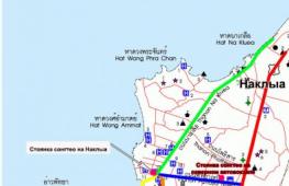
Use direct input of coordinates, in this case, the Google Maps router is mistaken, apparently due to the lack of roads and settlements in Antarctica.
Oddly enough, neither aliens, nor giant people, nor the fictional Illuminati, nor, especially, the parents of the pharaoh dynasty, were involved in the creation of these, as well as other “pyramid formations” of Antarctica.
The Vinson Massif, where “virtual archaeologists” spotted another “pyramid,” is part of the Ellsworth mountain system, rising 5140 m above the Earth’s surface, while almost 4 kilometers of this mountain system are firmly located in the thickness of the Antarctic glacier. The thing is that all the mountain systems of Western Antarctica were formed during the period of Alpine folding and are a geological continuation of the South American Andes. Of course, those same 500 meters of “pyramid mountain” that we see are only the upper part of a mountain range, the “anomalous” sharpness of the top part of which is explained by very little geological...
0 0
Photos from open sources
For many years, scientists and amateurs have been talking about the interesting pyramids that are located in Antarctica. They are very similar in shape to Egyptian ones, and, according to some researchers, are evidence of the existence of proto-civilizations. However, scientists decided to figure out what these unique pyramids actually are?
News about these growths in Antarctica was first published on the Internet in the summer of 2013. Then the scientists presented several photographs on video and gave several comments on them (see the video below). They said that the discovery was made by specialists from universities in the USA and Europe, but their names are never known.
But the video shows the logo of a group of scientists from the UK, Alien Disclosure Group (ADG), the author of the sensation was Stephen Hannard, but he was caught many times with false evidence of the existence of UFOs. It was found that the pyramids are two angles of one mountain...
0 0
10
THIS SCARED THE SCIENTISTS TO DEATH! PYRAMIDS OF DEATH!! SHOCK! DOCUMENTARY. SECRET. FROM 05/02/2017
THIS SCARED THE SCIENTISTS TO DEATH! PYRAMIDS OF DEATH!! SHOCK! DOCUMENTARY. SECRET. FROM 05/02/2017 *ENJOY WATCHING* SUBSCRIBE TO NEW VIDEOS https://www.youtube.com/channel/UCtXWXNUQZD0kMgS7dkdWWmQ?sub_confirmation=1 ©©©©©©©©©©©©©©©©©©©© ©©©©©©©©©©©©©©©©©©©©©©©©©©©©©© Film, documentary, online, UFO, in good quality, new 2016, TV series 2016, melodrama 2016, inexplicable, but true, discovery documentaries, national geographic documentaries, watch documentaries, documentary films 2016, films 2016, bbc documentaries, 2016, secrets, mystery, riddles, miracle people, telekinesis, documentary, film, 2016 , secrets of the world, secrets of the world with Anna Chapman, secrets of the world with Anna Chapman all episodes, Anna Chapman secrets of the world 2015 all series, secrets of the world with Anna Chapman watch online, UFO, yfo, UFO, aliens, contact, flying...0 0
An ancient structure in Antarctica.
From the editor: the author, who specializes in searching for anything (mostly missing aircraft), based on data from satellite photographs, this time made a new sensational discovery, and demands to take it seriously.
According to the author, this mountain range most likely was born as a result of strong volcanic activity in that region of Antarctica. Moreover, quite recently this massif was hidden by centuries-old ice, but the greenhouse effect and global warming made it possible to see what had been hidden for tens of thousands of years in a row.
If you look at the photo of this piece of land from 1999, you can see that at that time there was nothing in the photographs except ice and snow; all these “artifacts” appeared only after 2010. At the same time, they were recorded absolutely by accident, as a result of the usual cartographic work of satellites.
As the user found out, this area of Antarctica, called Queen Maud Land, belongs to Norway. Until 1967, several scientific stations were located there. Much work was carried out during the Third Reich. It was there, according to subsequent research by science fiction writers, that the legendary base of Germany, called New Swabia, was laid. However, no traces of the existence of such a base were ever found.
Meanwhile, many believed in the existence of the mythical New Swabia. The Wikipedia reference reads as follows: New Swabia (German: Neu-Schwabenland or Neuschwabenland) is the territory of Antarctica (the “German Antarctic sector” between 4°50" and 16°30" E), which was invaded by Nazi Germany from January 19 1939 to May 8, 1945 made territorial claims. Formally, Germany has not renounced these territorial claims to this day.
In 1947, the US Navy conducted the Highjump Antarctic Expedition under the command of Admiral Richard Byrd. However, due to losses, the expedition was curtailed. The official halt is due to difficult climatic conditions, however, there are other versions.
Currently, in territories south of 60° S. w. The Antarctic Treaty is in force, prohibiting the militarization of the region. The German Neumayer III station has been operating on the territory of Queen Maud Land since 2009. She gained fame due to an incomprehensible glow recorded by her webcams, which, according to ufologists, is another proof of the existence of UFOs. This base is located near the Schirmacher Oasis.
Schirmacher Oasis is an area in the central part of the Princess Astrid Coast. It is an ice-free area of the oasis of approximately 35 km², separated from the Lazarev Sea by the Nivlisen ice shelf, about 80 km wide. Coordinates 70° 45′ 0″ S, 11° 40′ 0″ E, - from the artifact found by a citizen journalist, 627 kilometers in the direction of the South-West.
Well, Queen Maud Land (Norwegian Dronning Maud Land) is a vast area on the Atlantic coast of Antarctica, the sector between 20° west and 44° 38" east longitude, which Norway claims, is its dependent territory. Area - about 2,500 000 km². It is predominantly a zone of ice shelves up to 200 km wide, adjacent to the continental ice sheet in the south. From the Princess Martha Coast to these rocks, the last station was located there from 1950 to 1967. In those years, the rocks discovered in the photographs were located. under a thick layer of ice, which is why no one has ever described them before.
Among the rocks, I discovered in the photo the outlines of huge pyramids, which do not look very much like natural formations. Moreover, according to auto research, the shape of the objects he discovered is identical to the pyramids in Mexico, left over from the disappeared Inca civilization.

Second, as a netizen notes, the construction is even larger. It resembles a huge building, with a large platform and geometrically correct steps. Coordinates 73°42"46.11"S, 4°16"33.97"W
According to the author, nowhere else in Antarctica are there such picturesque and anomalous rocks. Basalt rocks, volcanic tuft, granite, perhaps there are fossilized remains of trees. The researcher associates the absence of visible ice and snow with the fact that hot steam from volcanic activity is coming out of the ground somewhere. And erosion of the rock would allow a layer of soil to form. Thus, this piece of land could theoretically be quite suitable for living.

By the way, on the map of Admiral Piri Reis (Turkey, 16th century), it is the Queen Martha coast that is drawn free of ice and snow. It is worth emphasizing that at the time the map was created, Antarctica had not yet been discovered at all.

Moreover, no one in the world has seen the outline of the southernmost continent of the Earth. However, there is no ice on the Piri Reis map. But according to official data, ice bound Antarctica millions of years ago. But where did the medieval admiral get his information?
“Thus, perhaps everything I hypothesize is real,” concludes the author of the study (in fairness, it is worth noting that it is rather superficial - note “Reedus”). - Any of you can find this place on your own. Even if only in photographs, but study it in detail. Perhaps you will find something that even I did not notice. I think the time spent is worth it. If the pyramid and the building (or whatever it is?) really exist, then their value is simply enormous. And if they are not there, then another funny artifact will appear on the Google Earth map. Coordinates of the find: Pyramid: 73°42"35.72"S, 4°17"5.01"W and possibly the oldest building on Earth: 73°42"46.11"S, 4°16"33.97"W. And, by the way, icebergs do not form at a distance of 370 kilometers from the coast. Especially in rocky areas. So, there is nothing natural in this artifact. This place should really be explored. But official science does not need such a “headache”. Maybe there is a philanthropist who would like to find this abandoned city? If you’re lucky, any expenses will be worth it.”