An island that moves. Scary Sable Island (15 photos)
Sable Island is recognized not only as dangerous, but even cursed. It is constantly hidden behind dense fogs, its relief is absolutely flat, and due to the sandy rocks of the shores it can change color, adapting to the waters of the ocean.
It is no coincidence that Sable Island was named the ship devourer. This small piece of land can swallow a ship that runs aground here in just 2-3 months with the help of its quicksand. The ominous picture is complemented by occasionally rising from the same sands lost ships. From time to time they really just rise to the surface.
But that's not all of Sable's secrets. This island is nomadic. Due to the strong current, it constantly changes its shape, hiding in one place and appearing in another. It is located near the Canadian port of Halifax.
The location and size of the island, plotted on maps, very quickly become outdated; if on French, English, Italian maps of the 16th century, the length of the island varies from 150 to 200 miles (278-370 km), then according to the latest data, Sable is a long sandbank with a length of 24, width - less than 1 mile (44 x 1.5 km), stretching from east to west and moving east from average speed 230 m/year. The island is moving towards greater depth, and in the 19th century it was assumed that soon Sable, which had previously shrunk almost tenfold over 3 centuries, would completely disappear under water, however, for unknown reasons this did not happen, and over the last century it has even increased in size for 2 miles.
A storm on Sable is usually preceded by an unusually dazzling sunrise. It would seem that a wonderful morning should end the same way beautiful sunset. But God knows where a veil of leaden clouds appeared from, covers the sun, the sky turns black, and now the wind whistles subtly in the dunes. It grows stronger, howls, tears sand from the tops of the dunes and drives it across the island into the ocean... Because of this cutting sand, there is not a single tree on the island, not even a bush. Only in the valley between two ridges of dunes do stunted grass and wild peas grow.
An island with an almost flat surface ( maximum height 34 m) is extremely difficult to see from the sea, especially during the usual autumn and winter storms with 15-meter waves for this area. Sailors also claim that the sand of the island, like a chamelion, is always colored to match the color of the surrounding ocean or covered with fog, so that captains, even in clear weather, often did not see the danger until the moment of collision. Sable's quicksand has another insidious property - it absorbs any stranded or beached ship within 2-3 months; it is reliably known that ships with a displacement of 5,000 tons and a length of up to 120 m disappeared without a trace in the sands. How many hundreds of ships found their destruction on the shores of this small piece of land - their number is still not known, but among the sailors Sable received the persistent nickname “Ship Eater”. The last victim, the large American steamship Manhassent, was swallowed up by the island in 1947, after which 2 lighthouses and a radio beacon were hastily installed on the island, thanks to whose work maritime disasters in this area, declared dangerous for navigation, completely ceased.
The island is permanently inhabited by 15-25 people who service the lighthouses and hydrometeorological station and live in houses specially designed to withstand quicksand and hurricane winds. Living on a terrible cemetery island over the bones of many thousands of dead sailors turned out to be a severe test for the human psyche. Lighthouse keepers often talk about seeing ghosts overnight, ships being sucked into the sand, and people wandering the sandbanks. In the 50s, the caretaker had to be evacuated from the island, who was haunted every night by ghosts from the lost schooner Sylvia Mosher, begging him for help.
Geologists find this especially incredible because tectonic plates can only move at a speed of a few millimeters per year. How exactly Sable achieves such enormous speed is still a mystery.
Hundreds of merchant ships still fly past the island every day, flying the flags of countries all over the planet. Captains, plotting a course on maps, try to miss the island at a considerable distance. And although these days Sable no longer poses such a danger as before, sailors do not like to approach him. But what if?
Two lighthouses at each end of the island send warning rays into the night. Their light is visible 16 nautical miles in clear weather. Clear warning signals from the radio beacon can be heard on the air around the clock. It was thanks to him that shipwrecks off the coast of the island actually stopped. The last victim, the large American steamer Manhattan, was swallowed by the island in 1947.
Sable now belongs to Canada. It is still inhabited: its population is usually 15 - 20 people. These are specialists and workers of the Canadian Department of Transport who service the island's hydrometeorological center, radio station and lighthouses. Their responsibility also includes rescuing people in the event of a shipwreck and providing assistance to them. For this they went special training, and they have at their disposal the most modern life-saving equipment. Canadian specialists live on the island with their families. The manager of the island and the head of the radio beacon occupy two two-story cottages, the rest are housed in the so-called “caravans” - trailer houses. These dwellings were designed in such a way that they could withstand the destructive effects of cutting sand.
A power plant powered by a diesel generator was built on Sable. Several years ago, a large warehouse, a forge, a carpentry workshop, a hostel for shipwrecked people (in case it happened) and a hangar were built here, where metal whaleboats stand on rails, ready to be launched at any moment. These ships are not afraid of any waves, they are unsinkable and so stable that they practically cannot capsize. But if this happens, then a ship flooded with water is designed in such a way that it again stands on an even keel.
Of the old buildings on Sable, only the building of the old rescue station has survived, a kind of landmark of the island. The station was built from ship masts, topmasts and yards thrown up on the island by the ocean. “Name boards” with the names of the ships are nailed to the walls of this building. These boards also washed up on the island. These are, as it were, the remaining passports of former victims of the “ship devourer”.
A herd of three hundred wild ponies still lives on Sable. On those that are tamed, keepers travel around the coast of the island every day. They look to see if a yacht or fishing boat has washed up on the shallows, or if a bottle or plastic envelope with a note is lying on the sand - to study sea currents. Explorers of the island often encounter interesting finds in the sand. Each family living on Sable has thus created a good collection of sea relics. Old gold coins are still found in the sand.
Modern Sable Robinsons have learned to plant vegetable gardens and even orchards on the island. The main problem is to protect plants from cutting sand. They have dogs, cats and chickens. If the weather permits, which, by the way, happens very rarely, the island’s residents swim and go out into the ocean on whaleboats for fishing.
Every Saturday, the inhabitants of Sable Island gather one at a time in the house of one of the families, tune into a radiotelephone station to the mainland and talk with their relatives living in Canada and the United States.
Although Transport Canada, which oversees Sable, has tried to create maximum amenities for its residents, their work is not easy and dangerous. The meteorological conditions here are so harsh that people often experience nervous tension. Long-lasting hurricane-force storms often prevent island residents from leaving the shelter of their buildings for weeks. But this is not what they consider the most difficult part of their stay on the island. The question rests on another, rather psychological, rather than physical, tension. Indeed, living on a remote island, always shrouded in fog and tormented by storms, is not easy. But it’s even more difficult to constantly realize that you live not on an ordinary island, but on a cemetery island.
Every now and then caught in the sand human skulls and the bones make the inhabitants of the island remember that under their feet lie the remains of tens of thousands of shipwreck victims. Who enjoys this?
Nowadays, the great “ship devourer” is practically neutralized. From 1947 to this day, there has not been a single case of death of a large vessel in its quicksand. But the sailors still vigilantly peer into the fog as they pass by the dangerous island. The threatening warning of the radio beacon does not stop for a minute: “You are passing near Sable Island - a cemetery North Atlantic".
THE INCORPORABLE, WANDERING SABLE ISLAND.
It just so happens that Sable Island is considered one of the most dangerous and mysterious islands peace. It is located in the Atlantic Ocean and belongs to Canada. It lies southeast of Halifax (Nova Scotia). The area of the island is small, but for the sake of uniqueness, let’s say that its length is 42 km, and its width... no more than 1.5 km. From the air, Sable resembles some kind of huge worm. Although size is a relative thing for an island...
The fact is that Sable is a living island! Alive in the sense that it moves! No typo, the island really moves. If you look at the old nautical charts XVI-XVII centuries, you can see that the size of Sable is much larger than today - 270-380 km.

For almost five centuries, the name of the island struck terror into the hearts of sailors, and finally it gained such gloomy fame that it began to be called “the island of shipwrecks,” “the devourer of ships,” “the deadly saber,” “the island of ghosts,” “the cemetery of a thousand lost ships."

Refers to inhabited islands. There are 5 people living on Sable who work at the meteorological station and monitor the lighthouse. Note that previously the staff was larger and numbered 15-25 people. Since over time the danger from Sable ceased, the contingent was reduced.

Many call this place not just mysterious, but damned. Believe me, there are reasons for this. No one can say with certainty how many ships were lost here. Some put the figure at 350, others about 500. The important thing is that for many Sable was the last thing they saw in their lives. “Graveyard of the Atlantic” - the sailors call it. Inexplicably, the sand on the shores of the “living island” has the property of “adjusting” to the color of the sea waves. This optical effect is the main reason for the death of ships. The ships (especially in bad weather) crashed into the coastline at all speeds, and until the collision, the crew thought that there was only a vast ocean ahead...

Some lucky ones managed to survive and lived on the island for some time. But the stranded ships had the same fate - they were swallowed up by quicksand. In two months even from large ships there was no trace left! (hence the phrase “ship eater”).

Most modern geographers and historians agree that Sable was discovered by the French traveler Léry, who in 1508 sailed from Europe to the “Land of the Bretons” - a peninsula that the British later called Acadia and even later Nova Scotia. It is possible that supporters of this particular version are right, claiming that the navigator Léry gave the new island the French name “SABLE”. After all, in French it means “sand,” and the island actually consists only of sand.

Sable is located 110 miles southeast of Halifax, near the continental shelf - just in the area where the warm Gulf Stream meets the cold Labrador Current. It was this circumstance that led to the formation of a giant sandy crescent mound here, which once extended to Cape Cod. Geologists believe that Sable is nothing more than the peak of this crescent protruding from under the water.

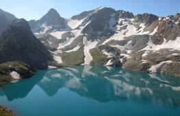
In its current state, the island stretches from east to west for 24 miles. The predominant terrain is dunes and sand hills. In some places there are areas of herbaceous vegetation. The highest “mountain” here is Riggin Hill, 34 meters high. Four miles from the western tip of the island is the semi-salty Lake Wallace, no more than four meters deep. Although it does not communicate with the ocean, waves still enter it by rolling over the dunes.

The western end of the island, under the continuous action of currents and waves of the Atlantic, is gradually eroded and disappearing, while the eastern end is washed out and lengthened, and thus the island continuously moves east, gradually moving away from the shores of Nova Scotia. It is estimated that over the past two hundred years, Sable has “walked” almost ten nautical miles across the ocean. The current speed of its movement is also known - about 230 meters per year.

The main danger that awaits ships near Sable is the quicksand of the shallows, a kind of “ocean quagmire.” Sailors and fishermen seriously say that they tend to take on the color of ocean water. The swells of the treacherous island literally swallow the ships that are captured by them. It is reliably known that steamships with a displacement of five thousand tons and a length of 100-120 meters that found themselves on the Sable shallows completely disappeared from view within two to three months.

The moving and changeable Sable has been constant in only one thing since the days of the ancient Vikings: in its irreconcilable hostility towards passing ships.
Historical documents - for example, numerous volumes of the Chronicle of Shipwrecks, maritime chronicles and other sources - allow us to judge that in ancient times Sable served as a giant ship graveyard of the North Atlantic. Here, under many meters of sand, rest the sharp-chested canoes of the brave Vikings, the clumsy carracks and galleons of the Spaniards and Portuguese, the gulets of the fishermen of Brittany, the strong pine ships of the Nantucket whalers, the English smacks, the cutters from Goole, the heavy three-masted ships of the West India Company, the elegant American clippers... And this armada of sailing ships, which has sunk into oblivion, is crushed by the heavy hulls of sunken steamships that sailed under the flags of all countries of the world. Some stumbled upon it while getting lost in the fog and shroud of rain, others were carried to the shallows by the current, and most of ships found their last refuge here during storms.

Sometimes the sandbanks and dunes of the island, having moved under the influence of ocean waves, reveal to the human eye the remains of ships that disappeared a long time ago. Thus, a quarter of a century ago, the durable teak hull of an American clipper, which had gone missing in the last century, “resurrected” from shifting fishing lines. And three months later, dunes 30 meters high again grew above the hull... From time to time, broken masts and yards are exposed sailing ships, steamship pipes, boilers, pieces of rusted ocean liners and even submarines.

Sable is one of the most conscientious and generous suppliers of unique exhibits to the defunct museum of romantic relics of the past. The current inhabitants of the island find rusty anchors, muskets, sabers, grappling hooks and huge quantities of ancient coins in the dunes... In 1963, a lighthouse keeper discovered in the sand a human skeleton, a bronze boot buckle, a musket barrel, several bullets and a dozen gold doubloons minted in 1760 . Later, a thick stack of banknotes - British pounds sterling from the middle of the last century - worth ten thousand was found in the dunes.

Some estimates show that the value of the valuables buried in the sands of Sable is at modern exchange rates almost two million pounds sterling. This is only if we take into account the ships about which information has been preserved that at the time of death they were carrying valuable cargo on board.

The first “devouring” of a ship by Sable was recorded back in 1583. Then an English ship called “Delight”, part of Humphy Gilbert’s expedition, rammed the sands of the island due to poor visibility. The last disaster is considered to be a shipwreck in 1947: the steamship Manhasset could not avoid a collision with the island. The entire crew was saved. However, we managed to find information according to which in 1999 the yacht Merrimac “met” with the sands of the “living island” (the navigation instruments malfunctioned). The three-person crew was not injured. The fate of the yacht is unknown.

Sometimes “gentlemen of fortune” buried their treasures here. They burned false fires on the dunes to lure merchant ships into a trap.
How many crimes were committed here and how many criminals Sable hid will forever remain a mystery. Until now, many superstitious residents of Newfoundland and Nova Scotia consider Sable a place cursed by God and the abode of evil spirits and ghosts. That’s what they call it: “THE GHOST ISLAND” - “Ghost Island”.

In 1598, Sable suddenly turned into... hard labor. Here 48 criminals were disembarked from the French ship Marquis De La Roche. The Marquis actually intended to found a colony in Nova Scotia, but after a long storm his ship developed a leak. Having never reached his goal, De La Roche turned back to the shores of Europe. Seeing the island, the Marquis came up with nothing else but to land the “extra cargo” on Sable, and so that the convicts would not starve right away, he left them fifty sheep. The exiles were remembered only seven years later, and the King of France signed a pardon for them. In the summer of 1605, a ship sent to Sable brought eleven overgrown people, who had lost their human appearance, dressed in sheep's skins, to Cherbourg. The rest, unable to bear the severe hardships, died. Surprisingly, five of those who returned to their homeland asked the king to allow them to return to Sable. Henry IV not only agreed, but also ordered to supply them with everything they needed. This is how a small French colony was formed. And when in 1635 a ship returning from Connecticut to England was wrecked on Sable, its crew was rescued and taken to the American mainland by these French Robinsons.

The British intended to bet on dangerous island lighthouse and create a rescue station. Its servants were charged with the duty of providing assistance shipwrecked and save property from sea robbers. And in England itself at that time, notices were posted that, on pain of death, prohibited anyone other than rescuers from settling on the island without government permission.

What in 1802 bore the loud name “rescue station” was a tightly built barn about one and a half hundred meters from the shore. In it, an ordinary whaling whaleboat rested on wooden runners. Nearby is a stable. No, the horses were not brought here on purpose. Horses have lived here since ancient times, although no one really knows where they came from on Sable. According to one version, these are the descendants of cavalry horses that sailed to the island from a certain French ship that once perished on the shallows. According to another version, they were brought to the island by Thomas Hancock, the uncle of the famous John Hancock, a famous American patriot during the War of Independence. Sable's horses are more like large ponies. They are very hardy, live in herds, feed on sedge, wild peas and some flowers that grow only on Sable.

Every day, four rescuers rode around the island on horseback along the surf, walking in pairs towards each other. They searched for sails in the fog and looked to see if the ocean had thrown up the wreckage of the ship. A ship was spotted dying near the island... The watchmen galloped towards the barn and sounded the alarm. The oarsmen on duty harness four ponies into a team, which drag the whaleboat to the water. Having skillfully overcome the first three waves of the surf, the rowers rush to where the ship is in distress. Meanwhile, the rest of the rescuers, including the lighthouse keeper, are already racing to the scene by land. Then a rope is thrown from the sinking ship to the island: this is the only way to snatch people in trouble from Sable’s mouth.

In modern sailing directions, an important note remains: “If the ship becomes stranded near Sable Island, the crew should remain on board until the lifeboat station provides assistance. Practice shows that all attempts to escape on the ship’s boats invariably ended in human casualties.”

Perhaps Sable's most dramatic shipwreck was the sinking of the American passenger steamer State of Virginia on July 15, 1879. This ship, with a registered capacity of 2,500 tons and a length of 110 meters, was sailing from New York to Glasgow, carrying 129 passengers and crew. During a thick fog, the ship found itself on a sandbank on the south side of the island. 120 passengers and crew were rescued by the island service. The happy parents added a fourth to the names of the smallest rescued girl - Nellie Sable Bagley Hord.

In the middle of the 19th century, a new station building was built on the island, and the wooden whaleboat was replaced with an iron one. In 1893, an even more substantial building for rescuers was erected, but a strong storm destroyed it to the ground in one night.

The situation with the lighthouses on Sable was much worse. At first, the wooden structure of the only lighthouse tower rose in the middle part of the island. In 1873, when, despite numerous repairs, the tower completely fell into disrepair, the lighthouse was replaced by two new ones - metal, openwork design. The eastern lighthouse served safely for about a hundred years, but the western one had to be changed several times: the insatiable Sable “swallowed”... six of its lighthouses!

Ships still pass by the island every day - hundreds of merchant ships flying the flags of countries all over the planet. Captains, plotting a course on maps, try to miss the island at a considerable distance. And although these days Sable no longer poses such a danger as before, sailors do not like to approach him. What if?.. God knows, these shallows changing shape every day...
Two lighthouses send warning rays into the night. Their light is visible 16 nautical miles in clear weather. Clear warning radio signals are heard on the air around the clock. It was thanks to them that shipwrecks off the coast of the island actually stopped. The last victim, a large American steamship called the Manhassent, was swallowed up by the island in 1947.

Sable now belongs to Canada. It is still inhabited: usually 15-25 people live here. These are specialists and workers of the Canadian Department of Transport who service the island's hydrometeorological center, radio station and lighthouses. Their duties also include rescuing people in the event of a shipwreck and providing assistance to them. For this purpose, they have undergone special training and have the most modern rescue equipment at their disposal. Canadian specialists live on the island with families.

There are only two real houses here - for the island manager and the head of the radio beacon. The rest are housed in “caravans” - trailer houses. These dwellings were specially designed to withstand the destructive effects of cutting sand. There is also a small power station.

Three hundred wild ponies still live on Sable. On those that are tamed, keepers travel around the coast of the island every day. They look to see if a yacht or fishing boat has washed up on the shallows, or if a bottle or plastic container with a note is lying on the sand, which is used to study sea currents.
December 18, 2013Sable Island, owned by Canada, is one of the most mysterious, enigmatic and strange places on the map of the Earth. It is located near Halifax, a Canadian port, in the north Atlantic Ocean. It is at this point that the warm Gulf Stream meets the cold Labrador Current.
Translation of the name of the island from different languages will sound like “sand”, “black, mourning color”. And the people of Canada call it nothing more than “octopus tentacles.” Strange…
The size and shape of Sable Island are also special. It resembles a crescent moon that is just over 40 km long. Its greatest width is approximately 1.5 km.

Mysteries of the nomadic Sable Island
Cursed island, ship killer, ship devourer, treacherous place - these are the epithets this small island. What's the matter? It turns out that this narrow strip of land is constantly moving at an incredible speed - almost 200 meters per year! The island itself is often covered in thick fog. Low and flat, hidden in the darkness, it seems to be waiting for prey, hiding behind the waters of the cold ocean. During a strong storm and high waves, it is completely impossible to notice the ghost island.
On Sable Island, sand can change its color to match the color of the ocean waters. This is another incredible feature of the strange island. The contours of the island are constantly changing, because a strong current erodes the sand on one side and washes it on the other. This is the reason for the high speed of the island's movement in an easterly direction. Geologists are at a loss. Such a movement is nonsense... After all, Sable is located on a powerful tectonic plate that drifts only millimeters per year! It turns out that this island is moving faster than the ocean floor! It is still unclear why this happens.
"Graveyard of the Atlantic" is the second name for the ominous Sable Island. There have been more than 300 shipwrecks near the island. If a ship washed up on this piece of land, a terrible fate awaited it. The quicksand of the nomadic island swallowed the ship within a couple of months. The landscape of the island is quite gloomy. Sometimes Sable, as if wanting to terrify the world, returns the remains of ships to the surface. From somewhere they reappear on the surface of the island.

Is there life on the ominous Sable Island?
Only grass and rare low plants grow on the island. All the trees planted here died. Here live wild horses, similar to ponies, of which there are about three hundred, and a large colony of rare seals - tevyak. Wild animals have adapted to the fact that there is only quicksand and the ocean around. At the beginning of 1960, the state took the inhabitants of the island under its protection. And now this amazing creation of nature is national treasure and a protected area. Therefore, you can visit the nomadic Sable Island only after receiving special permission.
Life on the treacherous island, of course, is not easy and dangerous. There are only no more than 30 people here permanently. These are employees of the meteorological station. They are trying to prevent new shipwrecks in these ominous waters. Canadian authorities have taken measures to improve shipping safety. Several lighthouses were built. After ensuring more or less normal visibility near the banks of the Sable terrible disasters stopped at the island.
Sable Island, this strange and mysterious creation of nature, steadily continues its movement. For what purpose, where and under the influence of what factors, in addition to the currents known to scientists, this island, more like an incomprehensible mysterious creature, is moving, no one can yet answer. Researchers continue to study this phenomenon, but there is still a long way to go to unravel the secrets of the nomadic island...
Nomadic Sable Island photo


It seems that the time when humanity sacredly trusted myths has gone forever. To explain something incomprehensible, we have science, thanks to which the place of the gods on the celestial chariots was taken by aliens, and the tambourines of shamans, who predicted the weather, were replaced by meteorological satellites. But, despite all the achievements of progress, human nature is still attracted by the incomprehensible and mystical.
On the verge of fiction
2012 - the film “Life of Pi” was released, based on the novel of the same name by Yann Martel. This adventure drama (which, by the way, won four Oscars) depicts a mysterious carnivorous island located somewhere in the middle of Pacific Ocean. According to the plot of the book, during the day this island was heavenly place, and at night it turns into a trap for all living things. After sunset, the algae that made up the island begin to secrete acid, and the lake located here becomes an acidic vat, digesting all living things. The only salvation was in the treetops, where they could wait out the night while the surface of the island bled gastric juice.
Fortunately, the movie predator island is a fiction, but, as you know, there is some truth in every fairy tale. For example, a thousand miles from Hawaii in the Pacific Ocean is located, which at first glance is a tropical paradise with lush vegetation, picturesque lagoons, reefs, white sand and everything else that attracts tourists. However, this island is uninhabited, and among those who have visited it, there is an opinion that Palmyra has a living and, without a doubt, black aura. External prosperity here is very deceptive: the weather changes instantly, calm lagoons are teeming with sharks, algae release toxic substances, and the surface of the island is full of poisonous insects. Even the fish that live in the creeks and lakes of the island are inedible, and a feeling of strange melancholy and hopelessness hangs in the air.
During World War II, the Americans used Palmyra as a springboard for an attack on Japan, but according to the soldiers who stayed there for several months, island life seemed like hell to them. The landing force was plagued by a series of mysterious suicides. The psychologically exhausted unit turned into a gang of deserters that wandered around the island and did God knows what. The reason for the unexpected soldiers' madness remained a mystery.
Ship Devourer
In the North Atlantic, one hundred and ten miles southeast of the Canadian port of Halifax, Sable Island is located, which is deservedly considered the most dangerous island ever marked on navigational charts. The peculiarity of Sable is that it is a sandbank, which, as a result of the meeting of the warm Gulf Stream and the cold Labrador Current, moves at a speed of 200-230 meters per year! Over the past two hundred years, Sable has “sailed” forty kilometers from Canada, although, of course, this “swim” should not be taken literally. The fact is that the western part of the island is constantly being washed away by waves, and the eastern, on the contrary, is overgrown with sand, like living tissue. In fact, these are quicksand in the ocean, and any ship washed ashore disappears without a trace after 2-3 months. The exact number of ships that hit the damned piece of land is unknown, but it definitely exceeded a hundred.
The island's main killer weapon is that it has an almost flat surface, and it is almost impossible to see it from the sea, especially during the storm season with fifteen-meter waves. According to legend, the sand that covers the island is like a chameleon, and even in clear weather is colored the color of the surrounding ocean. The ability to mimicry is characteristic only of living organisms, which led many sailors to think that the island, with its quicksand and sharp reefs, was “hunting” passing ships.
The Sable was first applied to official maps in the 16th century. At that time the length of the island was almost 200 miles. In the 19th century, scientists assumed that Sable, which had shrunk by almost 10 times over the previous 300 years, would soon completely disappear from the surface of the earth, but this did not happen. Moreover, over the past 100 years it has increased by two miles.
Almost every island on the planet is the surface part of a mountain, which, in turn, is located on tectonic plates. Islands cover our planet like pieces of a jigsaw puzzle, moving at speeds of several millimeters per year. Sable's travel speed is 100,000 times greater, suggesting that the island has no physical connection to any of Earth's tectonic plates. Numerous questions, to which there are still no intelligible answers, have pushed some scientists to the sensational and, at first glance, completely crazy idea that Sable is something like a living organism, which is based on silicon, and not carbon, like all living beings on our planet. If you agree with this theory, then you can try to explain where the sand comes from on the eastern part of the island, while the western part is constantly eroded by a strong ocean current. It is possible that sand (aka silicon) is a waste product of an insatiable ship devourer, which is what Sable appears to be.
It is curious that shortly before the start of World War II, the island was given to researchers new riddle. In the spring of 1939, storms of unprecedented force raged in this area, removing hundreds of tons of coastal sand, as a result of which a hole with the skeletons of eight ships formed on the island. It was in this pit, a hundred miles from Canada, that the remains of a Roman galley from ancient times were found! While the members of the scientific expedition sent to the island were arguing about the find, another storm broke out, and the tomb, which had been opened for a short time, was again covered with tons of damp sand.
The Curse of Bulawan Island
Bulawan - a small piece of land in the Banda Sea, which belongs to Indonesia, has long gained fame as a bad and dangerous place. The island became widely known after the plane of American pilot Willy Van der Haage crashed in its vicinity in 1989. The pilot was able to eject, but for the next 3 years he had the opportunity to be in Robinson's shoes, making many amazing discoveries.
During his forced confinement, Van der Haage crawled the length and breadth of the tropical island; his attention was especially drawn to the deep wells, clearly of artificial origin, which led to dry underground caves. Having descended into one of these caves, the American discovered a truly priceless treasure of gold coins, which, as is known from legends and horror stories, rarely brings happiness and longevity.
The treasure, found by an unwitting researcher, was in four clay jugs, sealed with natural asphalt. Inside the vessels were faceless, perfectly round coins, more like polished lenses. After the gold was delivered to America, an expert commission of numismatists and specialists in ancient culture could not determine the nationality of the coins, which gave reason to assume that these coins were a means of payment on the territory of some high-tech lost civilization, maybe even Atlantis.
The stay on the island ended as unexpectedly as it began: an Australian destroyer passing by saw a distress signal, thanks to which the missing pilot was finally rescued. Upon his return, the American gave a couple of dozen interviews in which he said that Bulavan is a powerful anomalous zone, and the cause of the plane crash, after which he became a prisoner of the island, was powerful geomagnetic deviations.
From newspaper articles, the public learned about the gold coins found, and detachments of black treasure hunters poured into Bulavan. The wells, adits, and caves of the island were repeatedly ransacked by lovers of quick money, and it should be noted that many did not return empty-handed. Only now treasure hunters came across not gold coins, but amazing silver bars in the shape of horse heads. These zoomorphic silver, according to scientists, were used in sacred rituals of a civilization unknown to us. But the most amazing thing is that there are no traces of artificial processing on the ingots, and we can say that this is nothing more than a masterpiece of the anomalous zone of Bulavan Island.
As for Willy Van der Haage, after undergoing retraining, he returned to his favorite job - flying, and, probably, this story would have had a happy ending if the pilot’s disfigured body had not been discovered in his own home in March 1993. The motive for the murder has not been fully clarified, but the police hastened to attribute everything to a banal robbery.
It is worth noting that since 1999, almost all the diggers who removed precious loot from the island were hanged, poisoned or shot! It’s simply ridiculous to talk about banal robberies here.
Drifting Nightmare
The islands of Palmyra, Sable, Bulavan are just a small list of mysterious, cursed islands fraught with danger for careless travelers. But varied anomalous zones, which are shrouded in a fog of secrets and mysteries, are nothing compared to the main island on this list, which is more than real, and whose appetite for devouring living flesh is much worse than the figment of Yann Martel’s imagination.
As sad as it sounds, the first place in the list of damned killer islands is occupied by a man-made creation - Garbage Island, which drifts between America and Eurasia. Currently, a huge landfill in the North Pacific Ocean is twice the size of the United States and is rightfully called the “Eastern Garbage Patch.”
The basis of the giant floating landfill is plastic waste, which is thrown into the ocean in huge quantities. The weight of this dump is already estimated at 100 mils. tons, and this figure continues to grow at a tremendous pace. At the same time, 70% of waste sinks to the bottom, so Garbage Island is just the tip of the iceberg.
Only two countries in the Pacific region are Australia and New Zealand– carry out effective control over plastic recycling, while advanced Asian states have designed and began serial production of equipment that processes all ship debris (plastic bottles, bags and other waste) into powder. Next, the shredded plastic, visually invisible to environmental services, is dumped into the ocean, saving enormous amounts of money.
The trouble is that over the past couple of decades we have become accustomed to such concepts as “humanitarian” and “ ecological catastrophy" It seems to us that if something like this happens not in the next block, then the consequences are unlikely to affect our own skin. However, Garbage Island is a disaster not of a local, but of a planetary scale. The worst thing is that this is no longer just a polluted aquatic environment, but a real cemetery of marine life. Every year, about a million birds and a hundred thousand mammals die from plastic waste dumped in the Pacific Ocean.
This happens according to the following scheme: under the influence of sunlight, plastic begins to disintegrate into small fractions without losing its polymer structure, then fish, jellyfish and other inhabitants of the ocean, confusing the waste with plankton, begin to eat it. Birds and mammals swallow larger things: lighters, bottle caps, syringes and toothbrushes. Of course, the “plastic diet” leads to death, but some of the commercial fish poisoned by chemicals still ends up on the average person’s plate.
How many of you would like to taste the meat of cattle raised on a farm near Chernobyl? Fish with a belly stuffed with plastic is little better, but the average consumer rarely thinks about what he puts in his mouth. Even when the obvious is explained to us, we pretend not to hear, or hope at chance, believing that misfortunes will affect anyone, but not us.
Similar garbage islands, albeit smaller ones, exist in all oceans. We can only admit that these drifting killers are already stretching their bony fingers far into the interior of the continents. And this is just the beginning...
South-east of the Canadian port of Halifax, in the waters of the North Atlantic, is located legendary island A sword that is notorious among many generations of sailors. It is believed that this island got its name from the French word saber, which means “sandy”. According to another version, Sable can be translated from English as “terrible”, “gloomy”. The sailors, in turn, nicknamed this piece of land "".
Sable Island barely protrudes above the surface of the ocean, its most high point(Rigging Hills) does not exceed 34 meters above sea level. This area is characterized by storms and thick fogs, the waves can rise so high that they cover the entire island.
Scientists have noticed one strange feature - Sable is a “drifting” island; in a year it manages to move about 230 meters to the east. The island owes its ability to move to two powerful currents - the cold Labrador Current and the warm Gulf Stream. These two currents constantly influence the sandy structure of the island, “building up” it east coast and at the same time undermining the Western one.
Why is Sable Island dangerous?
Usually, if a ship is smashed to pieces on the shore, and the crew is lucky enough to get to land, then we can talk about luck and salvation. However, this rule does not apply in the case of Sable Island. Sea vessels, thrown onto its shore by powerful ocean waves, became prisoners of Sable, ending up in ships capable of swallowing not only a light sailing ship, but also a solid ship with a displacement of up to 5,000 tons.
Scientists and geographers have found that in addition to Sable Island, there are several other places on our planet that could be called quicksand reserves. Firstly, it is located on east coast USA Cape Gateras, where shifting sands sometimes expose the rusty sides of steamships and the rotten hulks of sailing ships. Secondly, the Goodwin Shoals, located six miles southeast of England, are considered a “ship graveyard”. The Goodwin Shoals are all the more dangerous because the color of the sand here matches the color of the sea water.
But if the Goodwin Shoals are capable of swallowing a ship in literally a matter of minutes, then the quicksand of Sable Island can suck in its victim for quite a long time - for one to two months. It is also believed that some areas of the island are sinking faster than others.
The nature of quicksand
Physicists have developed a theory that explains the action of quicksand by peculiar electrical effects. According to their theory, grains of sand can be imagined as microscopic single-charge magnetic balls that have the ability to form free space around themselves.
Sand grains repel each other, thus acquiring the property of fluidity. Any object that impacts the surface of quicksand is surrounded by particles charged with positive ions. It sinks easily into the ground, experiencing virtually no friction. However, those who like to travel have nothing to fear - this is considered extremely rare.
video from the "dark" Sable Island